File:Voutement de la Senne FR.svg
Jump to navigation
Jump to search

Size of this PNG preview of this SVG file: 485 × 599 pixels. Other resolutions: 194 × 240 pixels | 388 × 480 pixels | 621 × 768 pixels | 828 × 1,024 pixels | 1,657 × 2,048 pixels | 1,416 × 1,750 pixels.
Original file (SVG file, nominally 1,416 × 1,750 pixels, file size: 106 KB)
Captions
Captions
Add a one-line explanation of what this file represents
Summary[edit]
| Description |
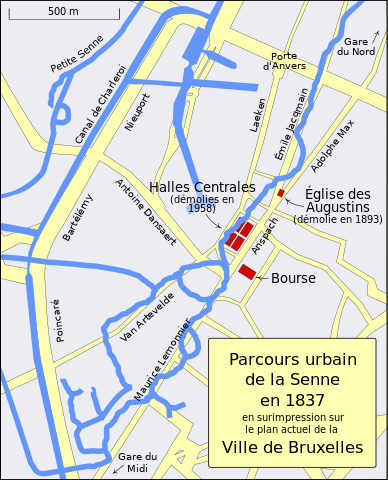
English: A map showing the course of the Senne River in 1837 superimposed upon the present-day streets of Brussels, including some landmarks
Français : Parcours urbain de la Senne en 1837 en surimpression sur la plan actuel de la Ville de Bruxelles. |
| Date | Today |
| Source | Travail propre |
| Author | MapMaster |
References[edit]
Built largely from present day street maps and these two historical maps:
- Brussels (Bruxelles) by Society for the Diffusion of Useful Knowledge (Great Britain); an 1837 map of Brussels
- Brussels by Letts, Son & Co. an 1883 map of Brussels
Other versions[edit]
Licensing[edit]
I, the copyright holder of this work, hereby publish it under the following license:
This file is licensed under the Creative Commons Attribution-Share Alike 3.0 Unported license.
- You are free:
- to share – to copy, distribute and transmit the work
- to remix – to adapt the work
- Under the following conditions:
- attribution – You must give appropriate credit, provide a link to the license, and indicate if changes were made. You may do so in any reasonable manner, but not in any way that suggests the licensor endorses you or your use.
- share alike – If you remix, transform, or build upon the material, you must distribute your contributions under the same or compatible license as the original.
File history
Click on a date/time to view the file as it appeared at that time.
| Date/Time | Thumbnail | Dimensions | User | Comment | |
|---|---|---|---|---|---|
| current | 23:27, 31 January 2008 | | 1,416 × 1,750 (106 KB) | MapMaster (talk | contribs) | Corrected some names, after review by Francophones |
| 04:06, 24 January 2008 |  | 1,416 × 1,750 (105 KB) | MapMaster (talk | contribs) | == Summary == {{Information |Description=A map showing the course of the Senne River in 1837 superimposed upon the present-day streets of Brussels, including some landmarks |Source=self-made |Date=Today |Author= MapMaster |Permission= | |
You cannot overwrite this file.
File usage on Commons
The following page uses this file:
File usage on other wikis
The following other wikis use this file:
- Usage on ce.wikipedia.org
- Usage on cv.wikipedia.org
- Usage on fr.wikipedia.org
- Usage on ru.wikipedia.org