File:Wfm islay landsat.jpg
Aller à la navigation
Aller à la recherche
Taille de cet aperçu : 800 × 593 pixels. Autres résolutions : 320 × 237 pixels | 640 × 474 pixels | 1 024 × 758 pixels | 1 280 × 948 pixels.
Fichier d’origine (1 280 × 948 pixels, taille du fichier : 285 kio, type MIME : image/jpeg)
Légendes
Légendes
Ajoutez en une ligne la description de ce que représente ce fichier
Description[modifier]
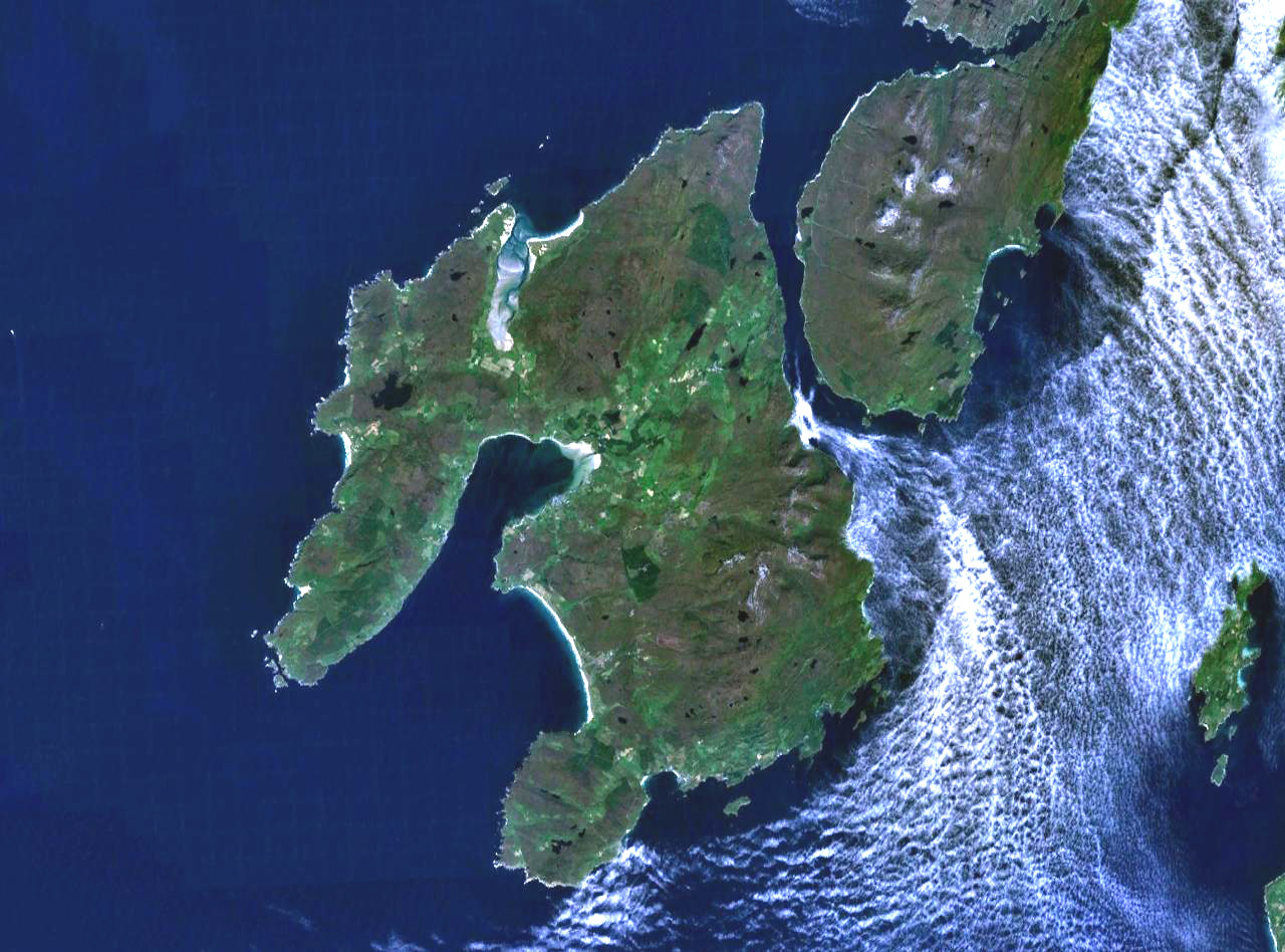
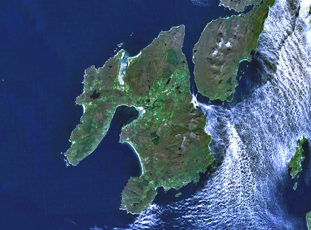
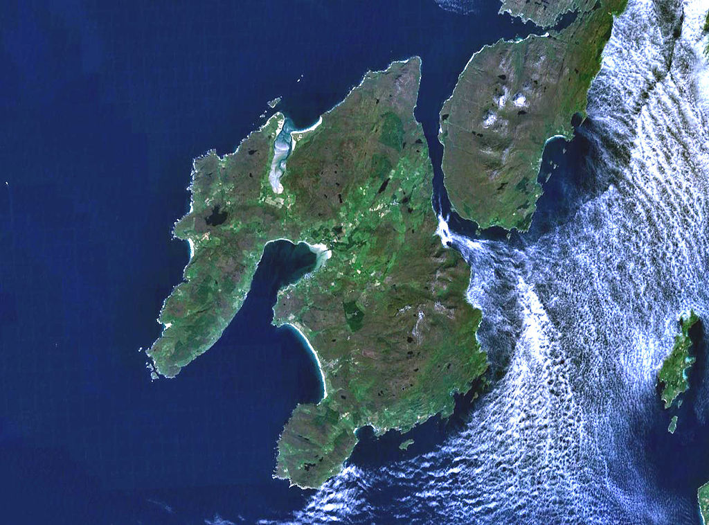
The island of Islay off the west coast of Scotland. The south part of the neighbouring island if Jura is visible to the northeast, and on the far east (right) of frame is the small island of Gigha.
Landsat 7 image, collected using NASA World Wind.

Conditions d’utilisation[modifier]
| Cette image est dans le domaine public car elle est constituée d'une capture d'écran du logiciel World Wind de la NASA qui utilise des données du domaine public, comme Blue Marble, MODIS, Landsat, SRTM, USGS ou GLOBE.
|
 |
Historique du fichier
Cliquer sur une date et heure pour voir le fichier tel qu'il était à ce moment-là.
| Date et heure | Vignette | Dimensions | Utilisateur | Commentaire | |
|---|---|---|---|---|---|
| actuel | 4 août 2005 à 19:28 | | 1 280 × 948 (285 kio) | Finlay McWalter (d | contributions) | The island of Islay off the west coast of Scotland. Landsat 7 image, collected using NASA World Wind. {{PD-USGov-NASA}} category:islands |
Vous ne pouvez pas remplacer ce fichier.
Utilisations locales du fichier
Les 16 pages suivantes utilisent ce fichier :
- Wikimedia logo mosaic
- Wikimedia logo mosaic/A-Z gallery/W-...
- Wikimedia logo mosaic/Colours gallery/Blue
- User:Ash Crow/test
- User:Bugboy52.4
- User:Cyc~commonswiki
- User:Lar/Mosaic2
- User:OhanaUnited/Wikispecies logo mosaic
- User:Prolineserver/mosaic
- User:Przykuta/Gender mosaic
- User:Twice25/Mosaic
- User talk:Symode09/Large
- Commons:STOP!!!! DO NOT DELETE THIS IMAGE TILL YOU REPLACE IT IN THE WIKIMEDIA LOGO MOSAIC
- Category:Islay
- Category:Maps of Islay
- Category:Villages on Islay
Utilisations du fichier sur d’autres wikis
Les autres wikis suivants utilisent ce fichier :
- Utilisation sur arz.wikipedia.org
- Utilisation sur br.wikipedia.org
- Utilisation sur ca.wikipedia.org
- Utilisation sur cy.wikipedia.org
- Utilisation sur da.wikipedia.org
- Utilisation sur de.wikipedia.org
- Utilisation sur de.wikivoyage.org
- Utilisation sur en.wikipedia.org
- Islay single malts
- Lagavulin distillery
- Port Ellen
- Port Ellen distillery
- Bowmore distillery
- Lagavulin
- Laphroaig distillery
- User:Chino
- Islay Airport
- Ardbeg distillery
- Bowmore
- Bruichladdich distillery
- Kilchoman distillery
- Port Charlotte, Islay
- Caol Ila distillery
- Port Askaig
- Portnahaven
- The Oa
- Rinns of Islay
- Bridgend, Islay
- Bunnahabhain
- User:Mike McGregor (Can)
- User:Pradiptaray
- Kilarrow Parish Church
- Eilean Mhic Coinnich
- Easter Ellister
- Ballygrant
- User:Tomyumgoong
- User:MJBurrage
- User:Svartalf
- User:UBX/User prefers Islay Malts
- User:Mike McGregor (Can)/code page
- User:A435(m)
- User:Jgp
- User:CzechOut
- User:Lindisfarne~enwiki
- User:AndreaPersephone
- User:NJW494
- User:AlexTiefling
- User:J.P.Lon
Voir davantage sur l’utilisation globale de ce fichier.