File:Yugoslaviamapfr.png
Jump to navigation
Jump to search
No higher resolution available.
Yugoslaviamapfr.png (330 × 355 pixels, file size: 181 KB, MIME type: image/png)
Captions
Captions
Add a one-line explanation of what this file represents
| Description |
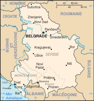
carte Serbie-et-Monténégro / map of The Federal Republic of Yugoslavia (Serbia and Montenegro) This is a map of The Federal Republic of Yugoslavia (Serbia and Montenegro) [FRY (S&M)] from as the 2000 CIA World Factbook as mirrored by the PCL. |
| Source | fr:Image:Yugoslaviamap.png |
| Author | fr:User:Marc Liger |
This image is in the public domain because it contains materials that originally came from the United States Central Intelligence Agency's World Factbook.
|
 |
| |
This work has been released into the public domain by its author, Marc Liger, at the English Wikipedia project. This applies worldwide. In case this is not legally possible: |
File history
Click on a date/time to view the file as it appeared at that time.
| Date/Time | Thumbnail | Dimensions | User | Comment | |
|---|---|---|---|---|---|
| current | 08:10, 1 August 2007 | | 330 × 355 (181 KB) | ~Pyb (talk | contribs) | {{Information |Description=carte Serbie-et-Monténégro / map of The Federal Republic of Yugoslavia (Serbia and Montenegro) |Source= fr:wp:Image:Yugoslaviamap.png |Date= |Author= fr:wp:User:Marc Liger |Permission= |other_versions= }} {{PD-use |
You cannot overwrite this file.
File usage on Commons
There are no pages that use this file.
File usage on other wikis
The following other wikis use this file:
- Usage on fr.wikipedia.org