File:Zoufftgen rail crash map-fr.svg
Jump to navigation
Jump to search

Size of this PNG preview of this SVG file: 800 × 580 pixels. Other resolutions: 320 × 232 pixels | 640 × 464 pixels | 1,024 × 743 pixels | 1,280 × 928 pixels | 2,560 × 1,856 pixels | 1,255 × 910 pixels.
Original file (SVG file, nominally 1,255 × 910 pixels, file size: 364 KB)
Captions
Captions
Add a one-line explanation of what this file represents
Summary[edit]
| Description |
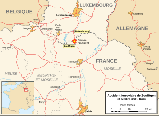
English: Map in French of the border region between France and Luxembourg showing the location of the rail crash occurred the 11th of October 2006 near the town of Zoufftgen, Moselle, France.
Français : Carte en français de la région de la frontière franco-luxembourgeoise montrant la localisation de l'accident ferroviaire survenu le 11 octobre 2006 près du village de Zoufftgen, Moselle, France. |
||
| Date | |||
| Source |
Own work Background reference map : Microsoft Encarta atlas (1999 edition) |
||
| Author | Eric Gaba (Sting - fr:Sting) | ||
| Permission (Reusing this file) |
|
Licensing[edit]
I, the copyright holder of this work, hereby publish it under the following license:
This file is licensed under the Creative Commons Attribution-Share Alike 2.5 Generic license.
- You are free:
- to share – to copy, distribute and transmit the work
- to remix – to adapt the work
- Under the following conditions:
- attribution – You must give appropriate credit, provide a link to the license, and indicate if changes were made. You may do so in any reasonable manner, but not in any way that suggests the licensor endorses you or your use.
- share alike – If you remix, transform, or build upon the material, you must distribute your contributions under the same or compatible license as the original.
File history
Click on a date/time to view the file as it appeared at that time.
| Date/Time | Thumbnail | Dimensions | User | Comment | |
|---|---|---|---|---|---|
| current | 16:34, 16 October 2006 | | 1,255 × 910 (364 KB) | Sting (talk | contribs) | Colour of departements names |
| 16:17, 16 October 2006 |  | 1,255 × 910 (364 KB) | Sting (talk | contribs) | Departements border lines modification | |
| 22:48, 15 October 2006 |  | 1,255 × 910 (364 KB) | Sting (talk | contribs) | Hidden / deleted roads (Inkscape bug) | |
| 22:40, 15 October 2006 |  | 1,255 × 910 (411 KB) | Sting (talk | contribs) | Suppression roads : more comprehensible | |
| 21:26, 15 October 2006 |  | 1,255 × 910 (411 KB) | Sting (talk | contribs) | Same modification | |
| 20:52, 15 October 2006 |  | 1,255 × 910 (411 KB) | Sting (talk | contribs) | Railroads lines larger | |
| 19:44, 15 October 2006 |  | 1,255 × 910 (411 KB) | Sting (talk | contribs) | {{Information |Description=Map in French of the border region between France and Luxembourg showing the location of the rail crash occurred the 11th of October 2006 near the town of Zoufftgen, Moselle, Fra |
You cannot overwrite this file.
File usage on Commons
The following page uses this file:
File usage on other wikis
The following other wikis use this file:
- Usage on en.wikipedia.org
- Usage on fr.wikipedia.org
- Usage on fr.wikinews.org
- Usage on lb.wikipedia.org
- Usage on pl.wikipedia.org