Oahu
Hoppa till navigering
Hoppa till sök
English: Oahu is the third largest of the Hawaiian Islands and most populous island in the State of Hawaii.
haw: Oʻahu
island of Hawaii, United States  Satelitní snímek ostrova Oahu  | |||||
| Ladda upp media | |||||
| Instans av | |||||
|---|---|---|---|---|---|
| Del av | |||||
| Plats | Honolulu County, Hawaii, USA | ||||
| Ligger i eller vid vattenområde | |||||
| Bredd |
| ||||
| Längd |
| ||||
| Högsta punkt | |||||
| Folkmängd |
| ||||
| Area |
| ||||
| Höjd över havet |
| ||||
 | |||||
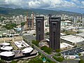
Honolulu[redigera]
-
 Bishop Museum
 -
 Downtown Honolulu as seen from Iolani Palace
 -
 Aerial view of Honolulu (with Aloha Tower)
 -
 Aerial view of Honolulu
 -
 Aerial view of Honolulu (with Waterfront Towers Condos)
 -
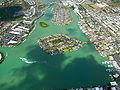
 Aerial view of Honolulu (with Magic Island, Ala Moana Beach Park, Ala Wai Yacht Harbor)
 -
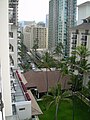
 Aerial view of Honolulu (with Halekulani, Sheraton hotels)
 -
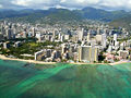
 Aerial view of Honolulu (with blue waters of Waikiki Beach)
 -
 Aerial view of Honolulu (with Waikiki Beach and Kapiolani Park)
 -
 Aerial view of Honolulu (from Diamond Head point)
 -
 Aerial view of Honolulu (with Honolulu Airport, H-1, and Navy-Marine Golf Course)
 -
 Departing from Honolulu International Airport, viewing at the port of Honolulu
 -
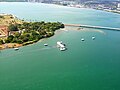
 Pearl Harbor, Hawaii (Aug. 29, 2003)
 -
 Aloha Tower lights the night sky of Honolulu Harbor.


Oahu[redigera]
-

-
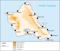 Oahu map
 -
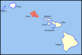 Oahu location map
 -
 Diamond Head Kapiolani Park
 -
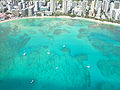
 Aerial view of Hanauma Bay
 -
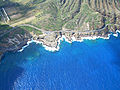 Aerial view of Lanai lookout
 -
 Ground view of Lanai lookout (north)
 -
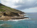 Ground view of Lanai lookout (south)
 -
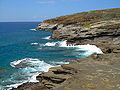
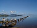
 Ground view of north shore
 -
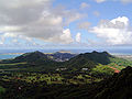
 Aerial view of Ko'olau mountains
 -
 Aerial view of Ko'olau mountains (with Koko Head Crater)
 -
 Aerial view of Ko'olau mountains (with H-3 tunnels)
 -
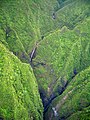 Aerial view of Sacred Falls
 -
 Aerial view of Sacred Falls
 -
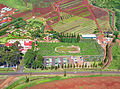 Aerial view of Dole Pineapple Maze, largest maze in the world (far)
 -
 Aerial view of Dole Pineapple Maze (near, but blurry)
 -
 Aerial view of battleship docked in Pearl Harbor
 -
 Aerial view of USS Arizona Memorial
 -
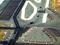 Aerial view of F-177 Stealth Fighter on runway at Honolulu airport
 -
 Aerial view of Puuikena Drive (winding mountain road)
 -
 Aerial view of Anapalau Street (island neighborhood/subdivision)
 -
 Kaneohe Bay
 -
 Kaneohe Bay
 -
 Kaneohe Bay
 -
 A view from the Pali Gap towards the Windward Coast on the island of Oahu
 -
 Makua Valley, West Oahu
 -
 Nuʻuanu Pali

.png)


Hotels[redigera]
-
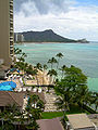
 Balcony view of Halekulani pool and beach area (Diamond Head in background)
 -
 Halekulani balcony view of Lewers Street
 -
 Halekulani balcony view of Diamond Head and surfers on Waikiki Beach
 -
 Halekulani balcony view (vertical) of Halekulani pool and beach area (Diamond Head in background)
 -
 Oahu Ihilani resort


Misc.[redigera]
-
 Tourist helicopter
 -
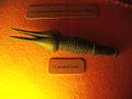 Bishop Museum display of cannibal fork
 -
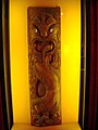 Bishop Museum display of Polynesian totem art
 -
 Bishop Museum
 -
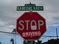 "Stop Driving" sign at Kaneohe Bay Drive, Oahu, Hawaii
 -
 Kapok planted in the Foster Botanical Garden, Honolulu, Hawaii.
 -
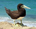 A Brown Booby in Oahu.
 -
-
 Rabbit Island


Sports[redigera]
-
 North Shore surfing
 -
 North Shore surfing
 -
 North Shore surfing
 -
 North Shore surfing
 -
 North Shore surfing
 -
 North Shore surfing


