Category:Beeston, Cheshire
Jump to navigation
Jump to search
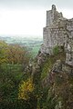
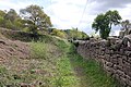
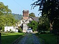
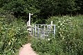
English: Beeston is a village and civil parish in the unitary authority of Cheshire West and Chester and the ceremonial county of Cheshire in the north of England. It is south of Tarporley, and close to the Shropshire Union Canal. Beeston Castle nearby is a spectacular clifftop ruin in the care of English Heritage. Peckforton Castle is not far away. The village also has a cattle market.
Norsk bokmål: Beeston er en landsby og et verdslig sogn i Cheshire i England. Stedet ligger sør for Tarporley, nær Shropshire Union-kanalen.
village and civil parish in Cheshire West, Cheshire, UK  | |||||
| Upload media | |||||
| Instance of | |||||
|---|---|---|---|---|---|
| Location | Cheshire West and Chester, Cheshire, North West England, England | ||||
| Said to be the same as | Beeston (Wikimedia duplicated page, civil parish) | ||||
 | |||||
Subcategories
This category has the following 2 subcategories, out of 2 total.
B
S
- Smithy Cottage, Beeston (9 F)
Media in category "Beeston, Cheshire"
The following 200 files are in this category, out of 208 total.
(previous page) (next page)-
 46100 "Royal Scot" Beeston, Cheshire.jpg 4,061 × 2,122; 1.24 MB
-
 A Pair of Porkers at Beeston - geograph.org.uk - 2858274.jpg 4,000 × 3,000; 3.47 MB
-
 A49 approaching Wild Boar Hotel - geograph.org.uk - 2900221.jpg 640 × 470; 87 KB
-
 A49 at Beeston - geograph.org.uk - 1827016.jpg 640 × 480; 54 KB
-
 A49 at Betty's Lane - geograph.org.uk - 2777076.jpg 640 × 480; 64 KB
-

-
 A49 entering Beeston - geograph.org.uk - 4439801.jpg 640 × 320; 51 KB
-
 A49 enters Beeston - geograph.org.uk - 2777085.jpg 640 × 480; 61 KB
-
 A49 in Beeston - geograph.org.uk - 2777096.jpg 640 × 480; 70 KB
-
 A49, Beeston Gate Farm - geograph.org.uk - 6083212.jpg 1,024 × 683; 242 KB
-
 Ad for Beeston Towers School 1939.jpg 800 × 491; 137 KB
-
 Bate's Mill Lane - geograph.org.uk - 5228205.jpg 640 × 480; 94 KB
-
 Bate's Mill Lane - geograph.org.uk - 5599906.jpg 1,280 × 851; 421 KB
-
 Bath Garden Cottage, Beeston, Cheshire.jpg 1,800 × 1,350; 594 KB
-
 Beech Tree Cottage, Beeston, Cheshire.jpg 1,800 × 1,350; 2.54 MB
-
 Beeston - geograph.org.uk - 2058157.jpg 800 × 600; 360 KB
-
 Beeston - geograph.org.uk - 2058175.jpg 800 × 600; 196 KB
-
 Beeston Castle - geograph.org.uk - 5228198.jpg 640 × 480; 57 KB
-
 Beeston Castle - geograph.org.uk - 5639936.jpg 5,184 × 3,456; 3.35 MB
-
 Beeston Castle - geograph.org.uk - 5745088.jpg 4,032 × 3,024; 2.94 MB
-
 Beeston Castle - geograph.org.uk - 5850451.jpg 640 × 480; 95 KB
-
 Beeston Castle - geograph.org.uk - 5929269.jpg 3,184 × 2,123; 1.98 MB
-
 Beeston Castle - geograph.org.uk - 6348191.jpg 5,184 × 3,888; 3.96 MB
-
 Beeston Castle and Tarporley Signal Box - geograph.org.uk - 6342065.jpg 5,184 × 3,888; 3.45 MB
-
 Beeston Castle Cattle Market - geograph.org.uk - 1350600.jpg 640 × 479; 92 KB
-
 Beeston Castle Cattle Market - geograph.org.uk - 1350601.jpg 640 × 479; 100 KB
-
 Beeston Castle Gatehouse - geograph.org.uk - 5745093.jpg 3,024 × 4,032; 3.31 MB
-
 Beeston Castle Gateway from the Inner Ward - geograph.org.uk - 5406988.jpg 3,176 × 2,128; 1.59 MB
-
 Beeston Castle Lodge House - geograph.org.uk - 5030006.jpg 5,184 × 3,456; 6.99 MB
-
 Beeston Castle Lodge House - geograph.org.uk - 5030011.jpg 5,184 × 3,456; 6.93 MB
-
 Beeston Castle Ticket Office - geograph.org.uk - 5603215.jpg 1,280 × 851; 524 KB
-
 Beeston Castle walls - geograph.org.uk - 5454619.jpg 640 × 319; 57 KB
-
 Beeston Castle, Cheshire - geograph.org.uk - 5406548.jpg 3,176 × 2,136; 1.64 MB
-
 Beeston Castle. Path through Outer Gatehouse - geograph.org.uk - 6313641.jpg 4,608 × 3,456; 5.84 MB
-
 Beeston Castle. Rock cut ditch from Inner Gatehouse bridge - geograph.org.uk - 6313658.jpg 4,524 × 3,342; 5.65 MB
-
 Beeston Crag - geograph.org.uk - 5407143.jpg 3,184 × 2,136; 1.44 MB
-
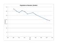 Beeston Pop Graph.pdf 1,650 × 1,275; 163 KB
-
 Beeston Walk - 10th April 2005 (24).JPG 1,600 × 1,200; 396 KB
-
 Beeston Walk - 10th April 2005 (30).JPG 1,600 × 1,200; 391 KB
-
 Beeston walk.JPG 1,664 × 416; 106 KB
-
 Beeston Wednesday Market - geograph.org.uk - 1558680.jpg 640 × 480; 79 KB
-
 Below Beeston Castle - geograph.org.uk - 5606613.jpg 1,280 × 851; 684 KB
-
 Bend in Moss Lane, Bunbury Heath - geograph.org.uk - 5225919.jpg 640 × 480; 56 KB
-
 Bend in Tattenhall Lane, Beeston - geograph.org.uk - 5225938.jpg 640 × 480; 82 KB
-
 Bishop Bennet Trail - geograph.org.uk - 814811.jpg 640 × 406; 70 KB
-
 Bishop Bennet Way - geograph.org.uk - 1566431.jpg 640 × 480; 63 KB
-
 Bishop Bennet Way Information Board - geograph.org.uk - 1819373.jpg 3,888 × 2,592; 2.62 MB
-
 Bishop Bennet Way near Beeston - geograph.org.uk - 1819368.jpg 3,888 × 2,592; 2.43 MB
-
 Bluebells in Beeston Castle - geograph.org.uk - 5862511.jpg 4,394 × 3,300; 2.24 MB
-
 Bridge and Gateway of Beeston Castle - geograph.org.uk - 5407121.jpg 3,176 × 2,136; 1.38 MB
-
 Bronze Age Roundhouse reconstruction at Beeston Castle - geograph.org.uk - 6207388.jpg 5,184 × 3,456; 4.52 MB
-
 Brook Cottage, Beeston, Cheshire.jpg 1,800 × 1,350; 417 KB
-
 Brook Farm Cottage, Beeston.JPG 1,200 × 902; 245 KB
-
 Building on Whitchurch Road Beeston - geograph.org.uk - 4153293.jpg 3,327 × 2,450; 2.2 MB
-

-
 Cafe car park and railway bridge, Beeston - geograph.org.uk - 5168868.jpg 1,600 × 1,200; 798 KB
-
 Calf in an underpass - geograph.org.uk - 6259638.jpg 6,000 × 4,000; 3.38 MB
-
 Canal Near Beeston.jpg 1,984 × 1,488; 631 KB
-
 Castle View - geograph.org.uk - 4565789.jpg 640 × 426; 41 KB
-
 Castlegate Farm - geograph.org.uk - 118902.jpg 640 × 480; 76 KB
-
 Castlegate Farm, Beeston - geograph.org.uk - 206314.jpg 640 × 484; 155 KB
-
 Castlegate Farm, Beeston - geograph.org.uk - 2897107.jpg 640 × 480; 92 KB
-
 Castlegate Farm, Beeston - geograph.org.uk - 5225943.jpg 640 × 480; 71 KB
-
 Castleside Cottage, Beeston.jpg 1,800 × 1,350; 430 KB
-
 Caves below Beeston Castle - geograph.org.uk - 4942587.jpg 4,184 × 2,789; 5.3 MB
-
 Chester bound train passing Beeston Castle - geograph.org.uk - 6259631.jpg 6,000 × 4,000; 3.52 MB
-
 Chester to Shrewsbury railway line near Beeston - geograph.org.uk - 2456415.jpg 4,000 × 3,000; 3.61 MB
-
 Converted barns at Brook Bank Farm - geograph.org.uk - 1566427.jpg 640 × 480; 60 KB
-
 Country Lane, Beeston - geograph.org.uk - 2858300.jpg 3,000 × 4,000; 3.21 MB
-
 Cover of John Naylors book.jpg 800 × 668; 148 KB
-
 Crimes Brook - geograph.org.uk - 1566428.jpg 640 × 480; 109 KB
-
 Crimes Lane near Beeston - geograph.org.uk - 1819393.jpg 3,888 × 2,592; 1.99 MB
-
 Crimes Lane towards Beeston - geograph.org.uk - 1819379.jpg 3,888 × 2,592; 2.68 MB
-
 Curtain Wall of Beeston Castle - geograph.org.uk - 5407024.jpg 3,176 × 2,152; 1.46 MB
-
 Dean Bank approaching A49 - geograph.org.uk - 3930899.jpg 640 × 482; 96 KB
-
 Dean Bank looking east - geograph.org.uk - 3360131.jpg 640 × 480; 94 KB
-
 Dean Bank, Beeston - geograph.org.uk - 2858295.jpg 4,000 × 3,000; 2.46 MB
-
 Deanbank junction with A49 - geograph.org.uk - 6314474.jpg 4,208 × 2,810; 4.94 MB
-
 Entering Beeston at Mill Farm - geograph.org.uk - 2900224.jpg 640 × 457; 82 KB
-
 Entrance to Beeston Castle - geograph.org.uk - 5850435.jpg 640 × 480; 85 KB
-
 Entrance to The Wild Boar Hotel - geograph.org.uk - 4439794.jpg 640 × 307; 57 KB
-
 Farm buildings, Beeston - geograph.org.uk - 5225932.jpg 640 × 456; 62 KB
-

-
 Farmland near Bunbury Heath - geograph.org.uk - 4299551.jpg 4,320 × 3,240; 2.92 MB
-
 Field between the canal and railway - geograph.org.uk - 4565793.jpg 640 × 426; 35 KB
-
 Field entrance off Moss Lane - geograph.org.uk - 5225928.jpg 640 × 480; 85 KB
-
 Field of oilseed rape near Beeston - geograph.org.uk - 1559667.jpg 640 × 480; 78 KB
-
 Field path parallel with Moss Lane leading towards Beeston - geograph.org.uk - 5219719.jpg 5,184 × 2,920; 4.24 MB
-
 Fields - geograph.org.uk - 814812.jpg 640 × 441; 52 KB
-
 Fields Cottage at Beeston - geograph.org.uk - 3930895.jpg 640 × 567; 72 KB
-
 Fields near the River Gower - geograph.org.uk - 5197639.jpg 640 × 453; 54 KB
-
 Finger post on the Sandstone Trail - geograph.org.uk - 1935400.jpg 2,592 × 3,888; 2.15 MB
-
 Footbridge on the 'Sandstone Trail'. - geograph.org.uk - 665298.jpg 640 × 480; 94 KB
-
 Footbridge over the River Gowy - geograph.org.uk - 1819145.jpg 3,888 × 2,592; 2.69 MB
-
 Footbridge over the River Gowy - geograph.org.uk - 1819194.jpg 3,888 × 2,592; 3.42 MB
-
 Footpath near Bishop Bennet Way - geograph.org.uk - 1819237.jpg 3,888 × 2,592; 2.6 MB
-
 Footpath to Peckforton - geograph.org.uk - 1819387.jpg 3,888 × 2,592; 2.01 MB
-

-
 Grazing off Bate's Mill Lane - geograph.org.uk - 5228210.jpg 640 × 480; 50 KB
-

-
 Grazing, Beeston - geograph.org.uk - 5228194.jpg 640 × 480; 52 KB
-
 Grazing, Bunbury Heath - geograph.org.uk - 5225916.jpg 640 × 480; 81 KB
-

-
 Handy for road and rail - geograph.org.uk - 2777097.jpg 640 × 480; 69 KB
-
 Honeysuckle Cottage Peckforton Road - geograph.org.uk - 6313394.jpg 4,562 × 3,394; 5.45 MB
-
 Inner ditch, Beeston Castle - geograph.org.uk - 5605374.jpg 851 × 1,280; 397 KB
-
 Inner gatehouse, Beeston Castle - geograph.org.uk - 5604900.jpg 851 × 1,280; 325 KB
-
 Inner gatehouse, Beeston Castle - geograph.org.uk - 5605378.jpg 1,280 × 851; 412 KB
-
 Inner gatehouse, Beeston Castle - geograph.org.uk - 5606045.jpg 1,280 × 851; 423 KB
-
 John Naylor 1916.jpg 800 × 1,013; 166 KB
-
 Junction in Beeston village - geograph.org.uk - 6313399.jpg 4,462 × 3,254; 4.36 MB
-

-
 Lane near Beeston, Cheshire - geograph.org.uk - 1935454.jpg 3,888 × 2,592; 2.93 MB
-
 Leafy Cheshire - geograph.org.uk - 2406497.jpg 640 × 427; 98 KB
-
 Leaving Beeston, entering Tiverton - geograph.org.uk - 2777098.jpg 640 × 480; 53 KB
-
 Lockgate Coffee Shop - geograph.org.uk - 5785812.jpg 640 × 427; 267 KB
-

-

-
 Moat House Barn - geograph.org.uk - 1560241.jpg 640 × 480; 86 KB
-
 Moathouse Farm - geograph.org.uk - 860351.jpg 640 × 458; 88 KB
-
 Moathouse Farm, Beeston.jpg 1,800 × 1,350; 409 KB
-
 Modern bridge - Beeston Castle - geograph.org.uk - 5605365.jpg 851 × 1,280; 402 KB
-
 Moss Lane - geograph.org.uk - 5225926.jpg 640 × 480; 78 KB
-
 Moss Lane, Beeston - geograph.org.uk - 5225930.jpg 640 × 480; 57 KB
-
 National Cycle Route 45 - geograph.org.uk - 5228206.jpg 640 × 480; 101 KB
-

-
 Nothing Lives Forever! - geograph.org.uk - 2406535.jpg 640 × 427; 76 KB
-
 Old Buildings in Beeston, Cheshire - geograph.org.uk - 1935430.jpg 3,888 × 2,592; 2.71 MB
-

-
 Outer Ward, Beeston Castle - geograph.org.uk - 5606020.jpg 1,280 × 851; 406 KB
-

-
 Peckforton Castle 2016 060.jpg 5,184 × 3,456; 4.74 MB
-
 Peckforton Road, Beeston - geograph.org.uk - 1935444.jpg 3,888 × 2,592; 3.63 MB
-
 Peckforton Road, Beeston - geograph.org.uk - 3360129.jpg 640 × 481; 85 KB
-
 Perimeter Wall and Path at Beeston Castle Woodland Park - geograph.org.uk - 4941522.jpg 4,184 × 2,789; 4.24 MB
-
 Piper Cherokee above Beeston Castle - geograph.org.uk - 5929182.jpg 3,952 × 2,786; 1.43 MB
-
 Rail cutting and tunnel near Beeston Castle (5349).jpg 4,288 × 2,848; 6.43 MB
-
 Railway Bridge At Beeston - geograph.org.uk - 2060274.jpg 800 × 600; 255 KB
-
 Railway bridge over A49 at Beeston Brook - geograph.org.uk - 6314493.jpg 4,108 × 2,484; 4.7 MB
-
 Railway Foot Crossing near Crimes Lane - geograph.org.uk - 1819268.jpg 3,888 × 2,592; 6.25 MB
-
 Railway Foot Crossing near Crimes Lane - geograph.org.uk - 1819339.jpg 3,888 × 2,592; 2.76 MB
-
 Railway Foot Crossing Stile near Crimes Lane - geograph.org.uk - 1819283.jpg 2,592 × 3,888; 3.01 MB
-
 Railway Foot Crossing Stile near Crimes Lane - geograph.org.uk - 1819344.jpg 3,888 × 2,592; 3.74 MB
-
 Railway to Chester - geograph.org.uk - 5599537.jpg 1,280 × 851; 382 KB
-
 Railway to Crewe - geograph.org.uk - 5599551.jpg 1,280 × 851; 471 KB
-
 Remains of Beeston Castle - geograph.org.uk - 5228199.jpg 640 × 480; 39 KB
-
 Remains of the Outer Gatehouse of Beeston Castle - geograph.org.uk - 5541538.jpg 3,184 × 2,123; 2.07 MB
-
 River Gowy, Bate's Mill - geograph.org.uk - 5599506.jpg 1,280 × 851; 456 KB
-
 Shropshire Union Canal - geograph.org.uk - 4565799.jpg 640 × 426; 44 KB
-
 Shropshire Union Canal - geograph.org.uk - 4565801.jpg 640 × 426; 44 KB
-
 Shropshire Union Canal - geograph.org.uk - 4565813.jpg 640 × 285; 27 KB
-
 Signal box by railway at Beeston - geograph.org.uk - 5168742.jpg 1,600 × 1,200; 742 KB
-
 Signpost at bottom of Beeston Castle - geograph.org.uk - 409921.jpg 640 × 480; 104 KB
-
 South east tower, Beeston Castle - geograph.org.uk - 5606114.jpg 1,280 × 851; 449 KB
-
 Stubble field off Moss Lane - geograph.org.uk - 5225924.jpg 640 × 480; 69 KB
-
 Stubble field off Tattenhall Lane - geograph.org.uk - 5225936.jpg 640 × 474; 73 KB
-
 Stubble field off Tattenhall Lane - geograph.org.uk - 5225940.jpg 640 × 480; 97 KB
-
 Tabernacle Cottage - geograph.org.uk - 1558766.jpg 640 × 480; 65 KB
-
 Tattenhall Lane - geograph.org.uk - 3360127.jpg 640 × 480; 103 KB
-
 Tattenhall Lane, Beeston - geograph.org.uk - 2058183.jpg 800 × 600; 280 KB
-
 The A49 at Beeston - geograph.org.uk - 2858260.jpg 4,000 × 3,000; 2.45 MB
-
 The Chester-Shrewsbury railway line - geograph.org.uk - 1819310.jpg 3,888 × 2,592; 2.92 MB
-
 The Chester-Shrewsbury railway line - geograph.org.uk - 1819329.jpg 3,888 × 2,592; 2.89 MB
-
 The Duchess Of Sutherland Passing Beeston Castle.jpg 5,690 × 2,108; 5.38 MB
-
 The gateway of Beeston Castle - geograph.org.uk - 5168687.jpg 1,600 × 1,200; 762 KB
-
 The Home Farm, Beeston - geograph.org.uk - 5228201.jpg 640 × 480; 59 KB
-
 The Home Farm, Beeston - geograph.org.uk - 5605854.jpg 1,280 × 851; 412 KB
-
 The Inner Curtain Wall of Beeston Castle - geograph.org.uk - 5862516.jpg 5,184 × 3,456; 2.2 MB
-
 The Inner Ward and Inner Gatehouse at Beeston Castle - geograph.org.uk - 6207543.jpg 5,184 × 3,456; 4.86 MB
-
 The Inner Ward of Beeston Castle - geograph.org.uk - 5542081.jpg 3,184 × 2,123; 1.87 MB
-
 The Inner Ward of Beeston Castle - geograph.org.uk - 5542091.jpg 3,184 × 2,123; 1.99 MB
-
 The Moathouse, Beeston.jpg 1,800 × 1,350; 670 KB
-
 The Outer Gatehouse of Beeston Castle - geograph.org.uk - 5862498.jpg 5,184 × 3,456; 3.63 MB
-
 The Outer Ward of Beeston Castle - geograph.org.uk - 5542063.jpg 4,184 × 2,789; 2.88 MB
-
 The Outer Ward of Beeston Castle - geograph.org.uk - 5542066.jpg 3,184 × 2,123; 1.69 MB
-
 The Outer Ward of Beeston Castle - geograph.org.uk - 5862502.jpg 5,184 × 3,456; 3.11 MB
-
 The River Gowy - geograph.org.uk - 2406498.jpg 427 × 640; 95 KB
-
 The Sandstone Trail - geograph.org.uk - 5225942.jpg 640 × 480; 112 KB
-
 The Sandstone Trail approaching Beeston Castle - geograph.org.uk - 5109940.jpg 4,184 × 2,789; 4.32 MB
-
 The Sandstone Trail at Beeston - geograph.org.uk - 3654451.jpg 8,217 × 3,053; 4.66 MB
-
 The Sandstone Trail at Beeston, Cheshire - geograph.org.uk - 1935377.jpg 3,888 × 2,592; 4.37 MB
-
 The South East Tower of Beeston Castle - geograph.org.uk - 5639938.jpg 5,184 × 3,456; 2.7 MB
-
 The South Wall of Beeston Castle - geograph.org.uk - 5862505.jpg 5,184 × 3,456; 3.99 MB
-
 The view north from Beeston Castle - geograph.org.uk - 5862524.jpg 5,233 × 3,529; 3.94 MB
-
 The Walls of Beeston Castle - geograph.org.uk - 5407108.jpg 2,144 × 3,176; 1.3 MB
-
 The Wild Boar Hotel - geograph.org.uk - 4885813.jpg 3,391 × 2,245; 1.84 MB
-
 The Wild Boar Hotel, Cheshire - geograph.org.uk - 6273933.jpg 640 × 480; 61 KB
-
 Victorian ticket office at Beeston Castle - geograph.org.uk - 6313620.jpg 4,516 × 3,330; 5.41 MB
-
 View from Beeston Castle - geograph.org.uk - 5407062.jpg 3,192 × 2,144; 1.14 MB
-
 View from Beeston Castle - geograph.org.uk - 5606000.jpg 1,280 × 851; 381 KB
-
 View from Beeston Castle - geograph.org.uk - 5606634.jpg 851 × 1,280; 548 KB
-
 View from Beeston Castle - geograph.org.uk - 5606647.jpg 1,280 × 851; 350 KB
-
 View from Beeston Castle - geograph.org.uk - 5639943.jpg 5,184 × 3,456; 2.59 MB
-
 View from Beeston Castle - geograph.org.uk - 5850459.jpg 640 × 480; 93 KB
-
 View from Pulpit Rock at Beeston Castle - geograph.org.uk - 6026198.jpg 5,184 × 3,456; 4.85 MB
-
 View from the footbridge at Beeston Castle - geograph.org.uk - 6026186.jpg 5,184 × 3,456; 5.63 MB
-
 View from the Woodland Path at Beeston Castle - geograph.org.uk - 4940217.jpg 5,000 × 3,333; 7.11 MB
-

-
 View towards Helsby Hill from Beeston Castle - geograph.org.uk - 5542077.jpg 5,184 × 3,456; 4.25 MB
-
 Virgin Train at Beeston - geograph.org.uk - 3654419.jpg 6,308 × 4,551; 4.27 MB


.JPG)
.JPG)


.jpg)


