Category:High Point (New Jersey)
Jump to navigation
Jump to search
highest point in New Jersey  | |||||
| Upload media | |||||
| Instance of | |||||
|---|---|---|---|---|---|
| Location | High Point State Park, Sussex County, New Jersey | ||||
| Mountain range | |||||
| Topographic prominence |
| ||||
| Elevation above sea level |
| ||||
 | |||||
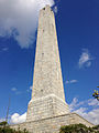
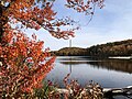
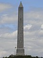
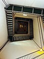
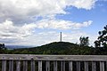
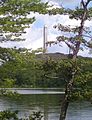
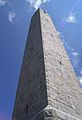
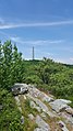
High Point, located in the northwestern part of New Jersey on the border of Wantage and Montague, Sussex County is the highest elevation in the state at 1,803 feet (550 m). It is just southeast of Port Jervis, New York. High Point is the highest peak of the Kittatinny Mountains. At the peak is the High Point Monument War Veterans Memorial, a 220-foot (67 m) tower, built in 1930 by Colonel Anthony Kuyser, who then donated it and the land around it which became the state park. Three different states can be seen from the summit: New Jersey, New York, and Pennsylvania.
Subcategories
This category has the following 2 subcategories, out of 2 total.
V
Media in category "High Point (New Jersey)"
The following 54 files are in this category, out of 54 total.
-
-

-

-

-
 2014-08-28 16 49 06 Coast and Geodetic Survey marker at High Point, New Jersey.JPG 3,264 × 2,448; 5.13 MB
-

-

-
 2014-08-28 17 02 58 View of High Point, New Jersey from the southwest.JPG 3,219 × 2,390; 4.32 MB
-
 2014-08-28 17 15 10 View of High Point, New Jersey from the shore of Lake Marcia.JPG 3,238 × 2,405; 4.37 MB
-
 2014-08-28 17 15 20 View of High Point, New Jersey from the shore of Lake Marcia.JPG 3,222 × 2,396; 4.01 MB
-

-

-

-
-

-

-
 Dramatic Obelisk.jpg 4,272 × 2,403; 3.56 MB
-
 Flickr - Nicholas T - Obelisk.jpg 2,016 × 1,512; 2.57 MB
-
 High Point 1 Sue Vanderschans.JPG 2,844 × 3,520; 1.52 MB
-
 High Point 10 Sue Vanderschans.JPG 2,736 × 3,648; 1.67 MB
-
 High Point 2 Sue Vanderschans.JPG 4,000 × 3,000; 1.96 MB
-
 High Point 3 Sue Vanderschans.JPG 3,000 × 4,000; 3.49 MB
-
 High Point 4 Sue Vanderschans.JPG 3,000 × 4,000; 2.09 MB
-
 High Point 5 Sue Vanderschans.JPG 1,667 × 2,806; 693 KB
-
 High Point 6 Sue Vanderschans.JPG 2,736 × 3,648; 1.98 MB
-
 High Point 7 Sue Vanderschans.JPG 2,423 × 3,335; 1.71 MB
-
 High Point 8 Sue Vanderschans.JPG 2,736 × 3,648; 1.54 MB
-
 High Point 9 Sue Vanderschans.JPG 3,358 × 2,232; 1.9 MB
-
 High Point Memorial Tower High Point Park district New Jersey.jpg 3,000 × 4,000; 5.37 MB
-
 High Point Monument - panoramio.jpg 1,536 × 2,048; 501 KB
-
 High Point Monument and Lake Marcia framed.jpg 1,626 × 2,119; 804 KB
-
 High Point Monument and Lake Marcia.jpg 1,470 × 2,097; 658 KB
-
 High Point Monument from approach.jpg 1,502 × 2,120; 616 KB
-
 High Point Monument from below.jpg 1,568 × 2,304; 810 KB
-
 High Point Monument from roadway.jpg 1,266 × 1,660; 457 KB
-
 High point monument high point state park new jersey.jpg 3,648 × 2,736; 3.08 MB
-
 High Point Monument Montague.jpg 3,024 × 4,032; 2.26 MB
-
 High Point Monument. High Point State Park, NJ.jpg 4,523 × 3,231; 5.27 MB
-
 High Point Monument.jpg 2,668 × 4,229; 1.09 MB
-
 High Point NJ Monument.jpg 3,024 × 4,032; 1.31 MB
-
 High Point Park.jpg 3,024 × 4,032; 1.57 MB
-
 High Point, NJ.jpg 844 × 633; 157 KB
-
 HighPointMonumentNJC68E7516-52C4-44C3-A1DB-D406C92DA788.jpg 3,024 × 4,032; 1.52 MB
-
 HighPointNJ20C3CABA3-4250-42C5-A7DD-417C0B13A961.jpg 3,024 × 4,032; 2.63 MB
-
 HighPointNJ36D9B9FF5-98F6-4512-9F7F-9CAD4C31FEA1.jpg 3,024 × 4,032; 4.82 MB
-
 HighPointNJ4E271F6A2-3DC3-41CC-A48A-DCC140EC4D65.jpg 3,024 × 4,032; 2.07 MB
-
 HighPointObelisk.jpg 3,008 × 2,000; 2.13 MB
-
 Hpsp aerial.jpg 960 × 686; 248 KB
-
 I-84 PA eb, MP 49.6, Nov. 2022.jpg 3,188 × 2,474; 1.38 MB
-
 Port Jervis train station.jpg 750 × 650; 486 KB
-
 Stairs up the High Point Monument.jpg 2,988 × 5,312; 3.5 MB
-
 Veterans Memorial Monument at High Point State Park in late spring sunset.jpg 2,579 × 1,720; 1.3 MB
-
 Veterans Memorial Monument at High Point State Park in late summer sunset.jpg 1,521 × 2,281; 1.22 MB
-
 View of the High Point Monument from the Appalachian Trail.jpg 2,988 × 5,312; 4.27 MB


Categories:
- High Point State Park
- Wantage Township, New Jersey
- Montague Township, New Jersey
- Geography of Sussex County, New Jersey
- Monuments and memorials in Sussex County, New Jersey
- Kittatinny Mountains
- Mountains of New Jersey
- Obelisks in New Jersey
- Monuments and memorials to veterans in New Jersey
- 50-99-meter-tall structures in New Jersey
- Highest points of U.S. states
- 67-meter-tall structures in the United States
- Marion Sims Wyeth