Category:Kriegerdenkmal (Hörbranz, Vorarlberg)
Jump to navigation
Jump to search
| Object location | | View all coordinates using: OpenStreetMap |
|---|
 | |||||
| Upload media | |||||
| Instance of | |||||
|---|---|---|---|---|---|
| Location | Hörbranz, Bregenz District, Vorarlberg, Austria | ||||
| Heritage designation | |||||
 | |||||
Media in category "Kriegerdenkmal (Hörbranz, Vorarlberg)"
The following 5 files are in this category, out of 5 total.
-
 Kriegerdenkmal 1. Weltkrieg an Pfarrkirche außen Hörbranz Vbg.jpg 2,304 × 3,072; 1.59 MB
-
 Kriegerdenkmal in Hörbranz (Vorarlberg) KZ Opfer.jpg 2,304 × 3,072; 2.68 MB
-
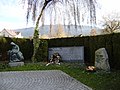 Kriegerdenkmal in Hörbranz Vbg Gesamtansicht.JPG 3,072 × 2,304; 1.71 MB
-
 Kriegerdenkmal in Hörbranz Vbg Skulptur.jpg 2,304 × 3,072; 2.38 MB
-
 Kriegerdenkmal in Hörbranz Vbg.JPG 3,072 × 2,304; 1.74 MB

_KZ_Opfer.jpg)

