Category:Parish church Maria Elend
Jump to navigation
Jump to search
| Object location | | View all coordinates using: OpenStreetMap |
|---|
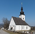
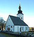
church building in Sankt Jakob im Rosental, Austria  | |||||
| Upload media | |||||
| Instance of | |||||
|---|---|---|---|---|---|
| Location | Sankt Jakob im Rosental, Villach-Land District, Carinthia, Austria | ||||
| Street address |
| ||||
| Heritage designation | |||||
 | |||||
Subcategories
This category has the following 2 subcategories, out of 2 total.
Media in category "Parish church Maria Elend"
The following 167 files are in this category, out of 167 total.
-
 AT-62467 Wallfahrtskirche Maria Elend 001.jpg 3,840 × 5,760; 2.02 MB
-
 AT-62467 Wallfahrtskirche Maria Elend 002.jpg 3,840 × 5,760; 2.94 MB
-
 AT-62467 Wallfahrtskirche Maria Elend 003.jpg 3,840 × 5,760; 2.59 MB
-
 AT-62467 Wallfahrtskirche Maria Elend 004.jpg 3,840 × 5,760; 2.06 MB
-
 AT-62467 Wallfahrtskirche Maria Elend 005.jpg 3,840 × 5,760; 2.22 MB
-
 AT-62467 Wallfahrtskirche Maria Elend 006.jpg 3,840 × 5,760; 2.89 MB
-
 AT-62467 Wallfahrtskirche Maria Elend 007.jpg 3,840 × 5,760; 2.93 MB
-
 AT-62467 Wallfahrtskirche Maria Elend 008.jpg 5,760 × 3,840; 2.9 MB
-
 AT-62467 Wallfahrtskirche Maria Elend 016.jpg 3,840 × 5,760; 2.54 MB
-
 AT-62467 Wallfahrtskirche Maria Elend 018.jpg 3,840 × 5,760; 2.18 MB
-
 AT-62467 Wallfahrtskirche Maria Elend 019.jpg 3,840 × 5,760; 2.17 MB
-
 AT-62467 Wallfahrtskirche Maria Elend 020.jpg 3,840 × 5,760; 2.22 MB
-
 AT-62467 Wallfahrtskirche Maria Elend 021.jpg 3,840 × 5,760; 2 MB
-
 AT-62467 Wallfahrtskirche Maria Elend 022.jpg 3,840 × 5,760; 2.52 MB
-
 AT-62467 Wallfahrtskirche Maria Elend 023.jpg 3,840 × 5,760; 3.11 MB
-
 AT-62467 Wallfahrtskirche Maria Elend 024.jpg 3,840 × 5,760; 2.37 MB
-
 AT-62467 Wallfahrtskirche Maria Elend 025.jpg 3,840 × 5,760; 2.68 MB
-
 AT-62467 Wallfahrtskirche Maria Elend 026.jpg 5,760 × 3,840; 2.37 MB
-
 AT-62467 Wallfahrtskirche Maria Elend 031.jpg 3,840 × 5,760; 2.52 MB
-
 AT-62467 Wallfahrtskirche Maria Elend 032.jpg 5,760 × 3,840; 1.88 MB
-
 AT-62467 Wallfahrtskirche Maria Elend 033.jpg 3,840 × 5,760; 2.59 MB
-
 AT-62467 Wallfahrtskirche Maria Elend 034.jpg 3,840 × 5,760; 1.66 MB
-
 AT-62467 Wallfahrtskirche Maria Elend 035.jpg 3,840 × 5,760; 2.5 MB
-
 AT-62467 Wallfahrtskirche Maria Elend 036.jpg 3,840 × 5,760; 1.76 MB
-
 AT-62467 Wallfahrtskirche Maria Elend 037.jpg 5,760 × 3,840; 2.24 MB
-
 AT-62467 Wallfahrtskirche Maria Elend 038.jpg 3,840 × 5,760; 2.74 MB
-
 AT-62467 Wallfahrtskirche Maria Elend 039.jpg 3,840 × 5,760; 2.47 MB
-
 AT-62467 Wallfahrtskirche Maria Elend 042.jpg 3,840 × 5,760; 2.74 MB
-
 AT-62467 Wallfahrtskirche Maria Elend 043.jpg 3,840 × 5,760; 2.42 MB
-
 AT-62467 Wallfahrtskirche Maria Elend 044.jpg 3,840 × 5,760; 2.93 MB
-
 AT-62467 Wallfahrtskirche Maria Elend 045.jpg 3,840 × 5,760; 2.55 MB
-
 AT-62467 Wallfahrtskirche Maria Elend 046.jpg 3,840 × 5,760; 1.83 MB
-
 AT-62467 Wallfahrtskirche Maria Elend 047.jpg 3,840 × 5,760; 4.04 MB
-
 AT-62467 Wallfahrtskirche Maria Elend 048.jpg 5,760 × 3,840; 1.96 MB
-
 AT-62467 Wallfahrtskirche Maria Elend 049.jpg 5,760 × 3,840; 2.03 MB
-
 AT-62467 Wallfahrtskirche Maria Elend 050.jpg 3,268 × 4,902; 2.04 MB
-
 AT-62467 Wallfahrtskirche Maria Elend 051.jpg 3,840 × 5,760; 4.8 MB
-
 AT-62467 Wallfahrtskirche Maria Elend 052.jpg 3,840 × 5,760; 3.66 MB
-
 AT-62467 Wallfahrtskirche Maria Elend 053.jpg 3,840 × 5,760; 3.3 MB
-
 AT-62467 Wallfahrtskirche Maria Elend 054.jpg 3,840 × 5,760; 2.99 MB
-
 AT-62467 Wallfahrtskirche Maria Elend 055.jpg 3,840 × 5,760; 3.29 MB
-
 AT-62467 Wallfahrtskirche Maria Elend 056.jpg 5,760 × 3,840; 3.15 MB
-
 AT-62467 Wallfahrtskirche Maria Elend 057.jpg 5,760 × 3,840; 1.98 MB
-
 AT-62467 Wallfahrtskirche Maria Elend 058.jpg 3,840 × 5,760; 1.76 MB
-
 AT-62467 Wallfahrtskirche Maria Elend 059.jpg 3,840 × 5,760; 4.76 MB
-
 AT-62467 Wallfahrtskirche Maria Elend 060.jpg 3,840 × 5,760; 4.72 MB
-
 AT-62467 Wallfahrtskirche Maria Elend 061.jpg 3,840 × 5,760; 3.37 MB
-
 AT-62467 Wallfahrtskirche Maria Elend 062.jpg 5,760 × 3,840; 4.12 MB
-
 AT-62467 Wallfahrtskirche Maria Elend 063.jpg 5,760 × 3,840; 8.14 MB
-
 AT-62467 Wallfahrtskirche Maria Elend 064.jpg 3,840 × 5,760; 2.68 MB
-
 AT-62467 Wallfahrtskirche Maria Elend 065.jpg 3,840 × 5,760; 2.69 MB
-
 AT-62467 Wallfahrtskirche Maria Elend 066.jpg 3,840 × 5,760; 2.61 MB
-
 AT-62467 Wallfahrtskirche Maria Elend 067.jpg 3,840 × 5,760; 3.12 MB
-
 AT-62467 Wallfahrtskirche Maria Elend 068.jpg 3,840 × 5,760; 4.84 MB
-
 AT-62467 Wallfahrtskirche Maria Elend 069.jpg 5,760 × 3,840; 4.7 MB
-
 AT-62467 Wallfahrtskirche Maria Elend 070.jpg 5,760 × 3,840; 3.1 MB
-
 AT-62467 Wallfahrtskirche Maria Elend 071.jpg 5,760 × 3,840; 3.47 MB
-
 AT-62467 Wallfahrtskirche Maria Elend 072.jpg 5,201 × 3,467; 5.35 MB
-
 AT-62467 Wallfahrtskirche Maria Elend 073.jpg 5,760 × 3,840; 3.67 MB
-
 AT-62467 Wallfahrtskirche Maria Elend 074.jpg 5,760 × 3,840; 3.44 MB
-
 AT-62467 Wallfahrtskirche Maria Elend 075.jpg 3,840 × 5,760; 6.22 MB
-
 AT-62467 Wallfahrtskirche Maria Elend 076.jpg 3,840 × 5,760; 4.43 MB
-
 AT-62467 Wallfahrtskirche Maria Elend 077.jpg 3,840 × 5,760; 6.22 MB
-
 AT-62467 Wallfahrtskirche Maria Elend 078.jpg 3,840 × 5,760; 6.17 MB
-
 AT-62467 Wallfahrtskirche Maria Elend 079.jpg 3,840 × 5,760; 4.7 MB
-
 AT-62467 Wallfahrtskirche Maria Elend 080.jpg 3,840 × 5,760; 4.78 MB
-
 AT-62467 Wallfahrtskirche Maria Elend 081.jpg 3,840 × 5,760; 4.62 MB
-
 AT-62467 Wallfahrtskirche Maria Elend 082.jpg 3,840 × 5,760; 2.85 MB
-
 AT-62467 Wallfahrtskirche Maria Elend 083.jpg 3,840 × 5,760; 3.15 MB
-
 AT-62467 Wallfahrtskirche Maria Elend 086.jpg 5,760 × 3,840; 5.14 MB
-
 AT-62467 Wallfahrtskirche Maria Elend 087.jpg 3,840 × 5,760; 5.9 MB
-
 AT-62467 Wallfahrtskirche Maria Elend 088.jpg 3,840 × 5,760; 2.14 MB
-
 AT-62467 Wallfahrtskirche Maria Elend 089.jpg 3,840 × 5,760; 3.6 MB
-
 AT-62467 Wallfahrtskirche Maria Elend 093.jpg 3,472 × 5,208; 2.82 MB
-
 AT-62467 Wallfahrtskirche Maria Elend 094.jpg 3,840 × 5,760; 3.67 MB
-
 AT-62467 Wallfahrtskirche Maria Elend 095.jpg 3,840 × 5,760; 2.91 MB
-
 AT-62467 Wallfahrtskirche Maria Elend 096.jpg 3,840 × 5,760; 3.64 MB
-
 AT-62467 Wallfahrtskirche Maria Elend 097.jpg 3,840 × 5,760; 3.04 MB
-
 AT-62467 Wallfahrtskirche Maria Elend 098.jpg 3,840 × 5,760; 2.86 MB
-
 AT-62467 Wallfahrtskirche Maria Elend 099.jpg 3,840 × 5,760; 3.89 MB
-
 AT-62467 Wallfahrtskirche Maria Elend 100.jpg 3,840 × 5,760; 4.41 MB
-
 AT-62467 Wallfahrtskirche Maria Elend 101.jpg 3,840 × 5,760; 3.63 MB
-
 AT-62467 Wallfahrtskirche Maria Elend 104.jpg 3,599 × 5,398; 4.31 MB
-
 AT-62467 Wallfahrtskirche Maria Elend 105.jpg 3,642 × 5,463; 4.79 MB
-
 AT-62467 Wallfahrtskirche Maria Elend 106.jpg 3,631 × 5,447; 5.6 MB
-
 AT-62467 Wallfahrtskirche Maria Elend 107.jpg 3,743 × 5,614; 6.1 MB
-
 AT-62467 Wallfahrtskirche Maria Elend 108.jpg 5,760 × 3,840; 3.94 MB
-
 AT-62467 Wallfahrtskirche Maria Elend 109.jpg 3,840 × 5,760; 3.73 MB
-
 AT-62467 Wallfahrtskirche Maria Elend 110.jpg 3,840 × 5,760; 4.11 MB
-
 AT-62467 Wallfahrtskirche Maria Elend 111.jpg 3,840 × 5,760; 2.78 MB
-
 AT-62467 Wallfahrtskirche Maria Elend 112.jpg 3,456 × 5,184; 3.54 MB
-
 AT-62467 Wallfahrtskirche Maria Elend 113.jpg 3,456 × 5,184; 3.89 MB
-
 AT-62467 Wallfahrtskirche Maria Elend 120.jpg 3,175 × 4,762; 2.94 MB
-
 AT-62467 Wallfahrtskirche Maria Elend 121.jpg 3,456 × 5,184; 3.92 MB
-
 AT-62467 Wallfahrtskirche Maria Elend 124.jpg 3,456 × 5,184; 3.7 MB
-
 AT-62467 Wallfahrtskirche Maria Elend 126.jpg 3,456 × 5,184; 3.63 MB
-
 AT-62467 Wallfahrtskirche Maria Elend 127.jpg 3,456 × 5,184; 4.25 MB
-
 AT-62467 Wallfahrtskirche Maria Elend 128.jpg 3,456 × 5,184; 3.63 MB
-
 AT-62467 Wallfahrtskirche Maria Elend 129.jpg 3,456 × 5,184; 3.44 MB
-
 AT-62467 Wallfahrtskirche Maria Elend 133.jpg 3,456 × 5,184; 3.64 MB
-
 AT-62467 Wallfahrtskirche Maria Elend 136.jpg 3,456 × 5,184; 4.2 MB
-
 AT-62467 Wallfahrtskirche Maria Elend 137.jpg 3,456 × 5,184; 3.5 MB
-
 AT-62467 Wallfahrtskirche Maria Elend 138.jpg 3,456 × 5,184; 3.02 MB
-
 AT-62467 Wallfahrtskirche Maria Elend 141.jpg 3,456 × 5,184; 2.5 MB
-
 AT-62467 Wallfahrtskirche Maria Elend 142.jpg 3,456 × 5,184; 3.22 MB
-
 AT-62467 Wallfahrtskirche Maria Elend 143.jpg 3,456 × 5,184; 4.39 MB
-
 AT-62467 Wallfahrtskirche Maria Elend 144.jpg 3,456 × 5,184; 3.42 MB
-
 AT-62467 Wallfahrtskirche Maria Elend 145.jpg 3,456 × 5,184; 4.98 MB
-
 AT-62467 Wallfahrtskirche Maria Elend 146.jpg 3,456 × 5,184; 4.8 MB
-
 AT-62467 Wallfahrtskirche Maria Elend 147.jpg 3,261 × 4,892; 2.94 MB
-
 AT-62467 Wallfahrtskirche Maria Elend 148.jpg 3,012 × 4,518; 2.18 MB
-
 AT-62467 Wallfahrtskirche Maria Elend 149.jpg 3,456 × 5,184; 3.5 MB
-
 AT-62467 Wallfahrtskirche Maria Elend 150.jpg 3,456 × 5,184; 4.59 MB
-
 AT-62467 Wallfahrtskirche Maria Elend 151.jpg 3,456 × 5,184; 4.67 MB
-
 AT-62467 Wallfahrtskirche Maria Elend 163.jpg 3,092 × 4,638; 5.56 MB
-
 AT-62467 Wallfahrtskirche Maria Elend 164.jpg 3,456 × 5,184; 4.4 MB
-
 AT-62467 Wallfahrtskirche Maria Elend 165.jpg 3,456 × 5,184; 4.29 MB
-
 AT-62467 Wallfahrtskirche Maria Elend 166.jpg 3,456 × 5,184; 4.9 MB
-
 AT-62467 Wallfahrtskirche Maria Elend 167.jpg 3,456 × 5,184; 6.5 MB
-
 AT-62467 Wallfahrtskirche Maria Elend 168.jpg 3,456 × 5,184; 6.51 MB
-
 AT-62467 Wallfahrtskirche Maria Elend 169.jpg 4,977 × 3,318; 4.37 MB
-
 AT-62467 Wallfahrtskirche Maria Elend 170.jpg 5,184 × 3,456; 4.29 MB
-
 AT-62467 Wallfahrtskirche Maria Elend 171.jpg 5,184 × 3,456; 3.51 MB
-
 AT-62467 Wallfahrtskirche Maria Elend 172.jpg 3,456 × 5,184; 5.14 MB
-
 AT-62467 Wallfahrtskirche Maria Elend 173.jpg 3,456 × 5,184; 4.64 MB
-
 AT-62467 Wallfahrtskirche Maria Elend 174.jpg 3,456 × 5,184; 5.25 MB
-
 AT-62467 Wallfahrtskirche Maria Elend 175.jpg 5,184 × 3,456; 4.01 MB
-
 Kirche Maria Elend innen nach hinten.jpg 4,542 × 2,613; 1.32 MB
-
 Kirche Maria Elend innen nach vorne.jpg 4,323 × 3,456; 2.03 MB
-
 Maria Elend Hochaltar.JPG 2,112 × 2,816; 889 KB
-
 MariaElendRosentalKirche01.jpg 2,736 × 3,648; 4.72 MB
-
 MariaElendRosentalKirche02.jpg 2,736 × 3,648; 3.87 MB
-

-
 Sankt Jakob im Rosental Maria Elend Wallfahrtskirche Maria Elend 15102016 4965.jpg 3,832 × 6,956; 15.67 MB
-
 Sankt Jakob im Rosental Maria Elend Wallfahrtskirche Maria Elend 20032015 0978.jpg 4,912 × 6,824; 15.68 MB
-
 Sankt Jakob im Rosental Maria Elend Wallfahrtskirche Maria Elend 20032015 0979.jpg 7,360 × 4,912; 16.26 MB
-
 Sankt Jakob im Rosental Maria Elend Wallfahrtskirche Maria Elend 20032015 0980.jpg 4,912 × 4,741; 8.5 MB
-
 Sankt Jakob im Rosental Maria Elend Wallfahrtskirche Maria Elend 20032015 0981.jpg 4,680 × 6,007; 13.61 MB
-
 Sankt Jakob im Rosental Maria Elend Wallfahrtskirche Maria Elend 27092011 344.jpg 2,832 × 2,488; 1.02 MB
-
 Sankt Jakob im Rosental Maria Elend Wallfahrtskirche Maria Elend Chor 26092023 4510.jpg 7,360 × 4,912; 17.03 MB
-
 Sankt Jakob im Rosental Maria Elend Wallfahrtskirche Maria Elend Chorschluss 26092023 4492.jpg 4,572 × 6,985; 18.98 MB
-

-
 Sankt Jakob im Rosental Maria Elend Wallfahrtskirche Maria Elend Gitterfenster 26092023 4504.jpg 7,160 × 4,912; 21.04 MB
-
 Sankt Jakob im Rosental Maria Elend Wallfahrtskirche Maria Elend N-Portal 26092023 4496.jpg 4,912 × 7,296; 23.86 MB
-
 Sankt Jakob im Rosental Maria Elend Wallfahrtskirche Maria Elend N-Portal 26092023 4497.jpg 6,910 × 4,912; 17.36 MB
-
-
-

-
 Sankt Jakob im Rosental Maria Elend Wallfahrtskirche Maria Elend Portal 20032015 0983.jpg 7,360 × 4,912; 17.42 MB
-
 Sankt Jakob im Rosental Maria Elend Wallfahrtskirche Maria Elend Portal 26092023 4499.jpg 7,360 × 4,912; 19.98 MB
-
 Sankt Jakob im Rosental Maria Elend Wallfahrtskirche Maria Elend Portal 26092023 4500.jpg 7,360 × 4,912; 21.3 MB
-
 Sankt Jakob im Rosental Maria Elend Wallfahrtskirche Maria Elend Portal 26092023 4503.jpg 4,912 × 7,360; 21.07 MB
-

-

-

-
 Sankt Jakob im Rosental Maria Elend Wallfahrtskirche Maria Elend SO-Ansicht 26092023 4508.jpg 6,744 × 4,912; 20.21 MB
-
 Sankt Jakob im Rosental Maria Elend Wallfahrtskirche Maria Elend SW-Ansicht 26092023 4501.jpg 4,646 × 6,789; 18.78 MB
-
 Sankt Jakob im Rosental Maria Elend Wallfahrtskirche Maria Elend SW-Ansicht 26092023 4502.jpg 6,742 × 4,912; 15.79 MB
-

-
 Sankt Jakob im Rosental Pfarrkirche Maria Elend N-Seite Eingang 15102016 4968.jpg 4,912 × 7,360; 15.46 MB
-
 Sankt Jakob im Rosental Pfarrkirche Maria Elend N-Seite Fresko hl Paulus 15102016 4971.jpg 3,939 × 7,014; 13.48 MB
-
 Sankt Jakob im Rosental Pfarrkirche Maria Elend N-Seite Fresko hl Petrus 15102016 4969.jpg 3,977 × 6,949; 12.97 MB
-
 Sankt Jakob Maria Elend Pfarrkirche Kapelle an Nordwand 16122007 19.jpg 3,872 × 2,592; 1.29 MB
-
 Sankt Jakob Maria Elend Pfarrkirche 11122007 01.jpg 1,614 × 1,356; 320 KB
-
 Sankt Jakob Maria Elend Pfarrkirche 11122007 02.jpg 1,632 × 1,752; 528 KB
-
 Sommer Linde 04 am Kirchplatz Maria Elend, Bezirk Villach Land, Kärnten.jpg 4,912 × 3,264; 7.34 MB
-
 Urlaub 2011-6 92 Maria-Elend.1.jpg 720 × 960; 111 KB


Categories:
- 15th-century architecture in Carinthia
- Churches in Bezirk Villach Land
- Churches in the Roman Catholic Diocese of Gurk
- Cultural heritage monuments in Sankt Jakob im Rosental
- Deanery Rosegg/Rožek
- Gothic churches in Carinthia
- Pilgrimage churches in Carinthia
- Saint Mary churches in Carinthia
- Maria Elend im Rosental
- White churches in Carinthia