Category:Stanton Fitzwarren
Jump to navigation
Jump to search
village in United Kingdom  | |||||
| Upload media | |||||
| Instance of | |||||
|---|---|---|---|---|---|
| Location | Swindon, Wiltshire, South West England, England | ||||
| official website | |||||
 | |||||
English: Stanton Fitzwarren is a village and civil parish northeast of Swindon. It is historically in Wiltshire, but is now part of the unitary authority of Swindon.
Subcategories
This category has only the following subcategory.
Media in category "Stanton Fitzwarren"
The following 95 files are in this category, out of 95 total.
-

-

-
 Across the lake, Stanton Park, Swindon - geograph.org.uk - 2611302.jpg 1,024 × 768; 303 KB
-
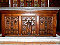 Altar, St Leonard’s Church, Stanton Fitzwarren - geograph.org.uk - 2649704.jpg 1,440 × 1,080; 804 KB
-

-
 Ash Covert near Stubb's Hill - geograph.org.uk - 3451778.jpg 4,000 × 3,000; 2.84 MB
-
 Banner, St Leonard’s Church, Stanton Fitzwarren - geograph.org.uk - 2649693.jpg 1,080 × 1,440; 668 KB
-

-
-
-
 Chancel, St Leonard’s Church, Stanton Fitzwarren - geograph.org.uk - 2649773.jpg 1,440 × 1,081; 620 KB
-
 Cycle path near the A361 roundabout - geograph.org.uk - 6267328.jpg 800 × 600; 120 KB
-
 Dismantled bridge, near Stanton - geograph.org.uk - 1097758.jpg 640 × 480; 144 KB
-
 Disused GWR Highworth branch line - geograph.org.uk - 2848883.jpg 2,848 × 2,136; 1.38 MB
-
 Early spring , Stanton Fitzwarren - geograph.org.uk - 357300.jpg 640 × 480; 137 KB
-

-
-
 Entrance to Stanton Park - geograph.org.uk - 2619724.jpg 640 × 480; 171 KB
-

-
 Field entrance off The Avenue - geograph.org.uk - 6267335.jpg 800 × 600; 138 KB
-

-
 Fields at Stanton Country Park - geograph.org.uk - 2619726.jpg 640 × 480; 105 KB
-
 Folly,Stanton Park, Swindon - geograph.org.uk - 2611279.jpg 1,024 × 768; 422 KB
-
 Font (1) St Leonard’s Church, Stanton Fitzwarren - geograph.org.uk - 2649785.jpg 1,080 × 1,440; 473 KB
-
 Font (2) St Leonard’s Church, Stanton Fitzwarren - geograph.org.uk - 2649790.jpg 1,080 × 1,440; 575 KB
-
 Font (3) St Leonard’s Church, Stanton Fitzwarren - geograph.org.uk - 2649794.jpg 1,080 × 1,440; 547 KB
-

-
 Font (5) St Leonard’s Church, Stanton Fitzwarren - geograph.org.uk - 2649801.jpg 1,440 × 1,440; 1.06 MB
-
 Footpath to Stanton Fitzwarren, Swindon - geograph.org.uk - 1526485.jpg 640 × 480; 308 KB
-
 Fruit, St Leonard’s Church, Stanton Fitzwarren - geograph.org.uk - 2649679.jpg 1,440 × 1,440; 753 KB
-
-

-

-

-
 Highworth Road by Vickers Roundabout - geograph.org.uk - 3886348.jpg 1,500 × 999; 107 KB
-
 Highworth Road from Supermarine Roundabout - geograph.org.uk - 3886351.jpg 1,500 × 989; 113 KB
-
 Interior, St Leonard’s Church, Stanton Fitzwarren - geograph.org.uk - 2649817.jpg 1,080 × 1,440; 474 KB
-
 Lodge and gatepiers to Stanton House, Stanton Fitzwarren - geograph.org.uk - 3454334.jpg 3,940 × 2,868; 5.29 MB
-
 Missing bridge, near Stanton - geograph.org.uk - 1097735.jpg 640 × 480; 120 KB
-
 Misty morning at Stanton Fitzwarren - geograph.org.uk - 3905393.jpg 640 × 427; 62 KB
-
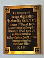
 Name on the War Memorial, Stanton Fitzwarren, Swindon - geograph.org.uk - 2649886.jpg 1,440 × 1,080; 988 KB
-
 Names on the War Memorial, Stanton Fitzwarren, Swindon - geograph.org.uk - 2646519.jpg 2,816 × 2,112; 2.81 MB
-

-

-

-

-
 Organ pipes, St Leonard’s Church, Stanton Fitzwarren - geograph.org.uk - 2649764.jpg 1,080 × 1,440; 729 KB
-
 Path heading to Highworth Road - geograph.org.uk - 3282404.jpg 640 × 480; 62 KB
-
 Path heading to Stanton Fitzwarren - geograph.org.uk - 3282393.jpg 640 × 480; 119 KB
-
 Path nearing South Marston Park - geograph.org.uk - 3282352.jpg 640 × 480; 161 KB
-
 Public footpath, Kingsdown Lane - geograph.org.uk - 2835115.jpg 2,848 × 2,136; 1.37 MB
-
 Pulpit, St Leonard’s Church, Stanton Fitzwarren - geograph.org.uk - 2649811.jpg 1,080 × 1,440; 538 KB
-
 Reredos, St Leonard’s Church, Stanton Fitzwarren - geograph.org.uk - 2649742.jpg 1,440 × 1,080; 871 KB
-
 Roundabout on the A361 Highworth Road - geograph.org.uk - 2619805.jpg 640 × 480; 171 KB
-
 Single track road for Stanton Park - geograph.org.uk - 2619727.jpg 640 × 480; 100 KB
-

-

-

-
 Spitfire Cafe, Hunt's Rise, South Marston Industrial Estate - geograph.org.uk - 3271453.jpg 4,000 × 3,000; 2.82 MB
-
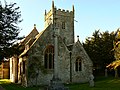
 St Leonard's church, Stanton Fitzwarren - geograph.org.uk - 2619800.jpg 640 × 480; 147 KB
-
 St Leonard's Church, Stanton Fitzwarren, Swindon - geograph.org.uk - 2611332.jpg 1,024 × 768; 194 KB
-
 Stanton Fitzwarren geograph-3988442-by-Ben-Brooksbank.jpg 2,240 × 1,495; 1.22 MB
-
 Stanton House Hotel, Stanton Fitzwarren - geograph.org.uk - 2619803.jpg 640 × 480; 121 KB
-
 Stirling Road - geograph.org.uk - 6267325.jpg 800 × 489; 100 KB
-
 Stubble field - geograph.org.uk - 357246.jpg 640 × 480; 92 KB
-

-

-
 The 'Forgotten Kingdom' at Stanton Park - geograph.org.uk - 2619732.jpg 640 × 480; 154 KB
-
 The A361 Highworth Road - geograph.org.uk - 2619811.jpg 640 × 480; 159 KB
-
 The A361, Highworth Road - geograph.org.uk - 3886354.jpg 1,500 × 994; 128 KB
-
 The Avenue - geograph.org.uk - 6267336.jpg 800 × 524; 104 KB
-
 The Avenue, Stanton Fitzwarren - geograph.org.uk - 3271433.jpg 4,000 × 3,000; 2.83 MB
-

-
 The Church of St Leonard at Stanton Fitzwarren - geograph.org.uk - 4690085.jpg 4,000 × 3,000; 3.12 MB
-
 The OId Rectory, Stanton Fitzwarren. - geograph.org.uk - 14958.jpg 640 × 426; 70 KB
-
 Tithe Barn, Trenchard Road, Stanton Fitzwarren - geograph.org.uk - 3454309.jpg 4,000 × 3,000; 5.73 MB
-
 Tower door, St Leonard’s Church, Stanton Fitzwarren - geograph.org.uk - 2646547.jpg 1,080 × 1,440; 696 KB
-
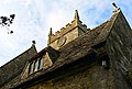
 Tower, St Leonard’s Church, Stanton Fitzwarren - geograph.org.uk - 2649896.jpg 1,080 × 1,440; 587 KB
-

-
 Tree and hedge, St Leonard’s Church, Stanton Fitzwarren - geograph.org.uk - 2649917.jpg 1,080 × 1,440; 923 KB
-
-

-
 View along the A361 Highworth Road - geograph.org.uk - 2619717.jpg 640 × 480; 173 KB
-

-

-

-
 West churchyard, St Leonard’s Church, Stanton Fitzwarren - geograph.org.uk - 2649902.jpg 1,440 × 1,080; 921 KB
-
 Yew and graves, St Leonard’s Church, Stanton Fitzwarren - geograph.org.uk - 2649910.jpg 1,440 × 1,080; 1.2 MB
-
 Crematorium view from NE - geograph.org.uk - 537093.jpg 640 × 480; 114 KB
-
 Footpath to Queenlaines farm - geograph.org.uk - 330776.jpg 480 × 640; 116 KB
-
 Footpath to South Marston - geograph.org.uk - 753201.jpg 640 × 480; 98 KB
-
 Kingsdown Lane - geograph.org.uk - 537098.jpg 640 × 480; 146 KB
-
 Pretty roadside - geograph.org.uk - 357286.jpg 640 × 480; 114 KB
-

-
 Sign and hedge - geograph.org.uk - 443707.jpg 640 × 480; 102 KB


,_Stanton_Park,_Swindon_-_geograph.org.uk_-_2611376.jpg)
_-_geograph.org.uk_-_6267330.jpg)


_St_Leonard%E2%80%99s_Church,_Stanton_Fitzwarren_-_geograph.org.uk_-_2649785.jpg)
_St_Leonard%E2%80%99s_Church,_Stanton_Fitzwarren_-_geograph.org.uk_-_2649790.jpg)
_St_Leonard%E2%80%99s_Church,_Stanton_Fitzwarren_-_geograph.org.uk_-_2649794.jpg)
_St_Leonard%E2%80%99s_Church,_Stanton_Fitzwarren,_Swindon_-_geograph.org.uk_-_2649797.jpg)
_St_Leonard%E2%80%99s_Church,_Stanton_Fitzwarren_-_geograph.org.uk_-_2649801.jpg)


_St_Leonard%E2%80%99s_Church,_Stanton_Fitzwarren_-_geograph.org.uk_-_2646529.jpg)
_St_Leonard%E2%80%99s_Church,_Stanton_Fitzwarren_-_geograph.org.uk_-_2646935.jpg)


,_St_Leonard%E2%80%99s_Church,_Stanton_Fitzwarren_-_geograph.org.uk_-_2648783.jpg)
,_Stanton_Fitzwarren_-_geograph.org.uk_-_2649876.jpg)


,_St_Leonard%27s_Church,_Stanton_Fitzwarren_-_geograph.org.uk_-_2649860.jpg)


