Uploads by Portolanero
Jump to navigation
Jump to search
For Portolanero (talk · contributions · Move log · block log · uploads · Abuse filter log)
This special page shows all uploaded files that have not been deleted; for those see the upload log.
| Date | Name | Thumbnail | Size | Description |
|---|---|---|---|---|
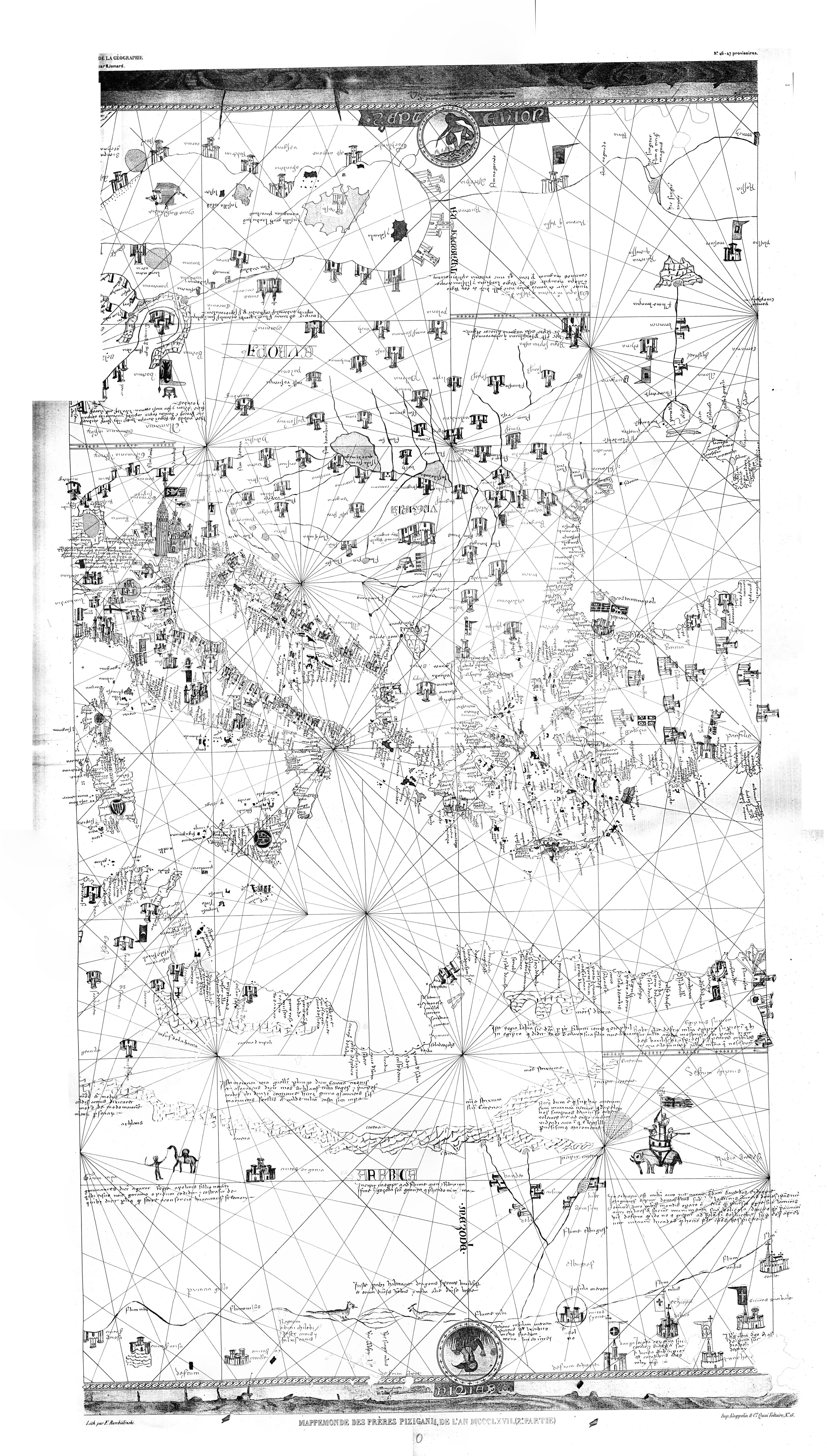
| 09:31, 17 June 2014 | East 1367 Pizigani Jomard.jpg (file) |  |
3.86 MB | {{Information |Description={{en|1=Part of the 1367 Pizigani portolan chart. Compilation from A3 photocopies from Jomard facsimile of 1849. Jomard, Edme François: Les Monuments de la géographie ou recueil danciennes cartes européenes et orientales... |
| 09:30, 17 June 2014 | Mid 1367 Pizigani Jomard.jpg (file) |  |
4.26 MB | {{Information |Description={{en|1=Part of the 1367 Pizigani portolan chart. Compilation from A3 photocopies from Jomard facsimile of 1849. Jomard, Edme François: Les Monuments de la géographie ou recueil danciennes cartes européenes et orientales... |
| 09:28, 17 June 2014 | West 1367 Pizigani Jomard.jpg (file) |  |
4.4 MB | {{Information |Description={{en|1=Part of the 1367 Pizigani portolan chart. Compilation from A3 photocopies from Jomard facsimile of 1849. Jomard, Edme François: Les Monuments de la géographie ou recueil danciennes cartes européenes et orientales... |
| 10:20, 29 January 2013 | Proposed Portolan History.jpg (file) |  |
322 KB | {{Information |Description={{en|1=The proposed transmission history from Nordenskioeld's pinax to the pre discovery maps and the portolans. }} | Source = {{Own work}} | Author = Portolanero | Date = 2012 | Other_fields = {{Credit... |
| 10:16, 29 January 2013 | Roman Globe Fresco Pompeii.jpg (file) |  |
111 KB | {{Information |Description={{en|1=A c. AD 50 Roman globe depiction with a north pole mountain like later time magnet mountains. Found in the Boscoreale villa near Pompeii. Size of original 61 x 39.7 cm. Metropolitan Museum of Art, Rogers Fund 1903. It ... |
| 10:15, 29 January 2013 | Two-Maps Trail Norse.png (file) |  |
492 KB | {{Information |Description={{en|1=Some Norse America features in context with the northern gon map. }} | Source = {{Own work}} | Author = Portolanero | Date = 2012 | Other_fields = {{Credit line |Author = http://en.wikipedia.org/... |
| 10:13, 29 January 2013 | Columbus 1492-IF.png (file) |  |
142 KB | {{Information |Description={{en|1= Columbus first voyage - Intention and Result. The intended course of Columbus was a perfect way to get on the track of a Norse ship to the gold land Yucatan in 1363. Was that Norse journey mentioned in the book Invent... |
| 10:11, 29 January 2013 | Mercator Letter 1577.jpg (file) |  |
435 KB | {{Information |Description={{en|1= Two pages with fire damage of Mercator's 1577 letter to John Dee. Whole letter at British Museum, Cotton MS Vitellius C. VII, fols. 264-269. :Left, foL 267 v. (according the folio numbers in E.G.R Taylor's text).... |
| 10:09, 29 January 2013 | Mercator-1569-Arctic.jpg (file) |  |
1.36 MB | {{Information |Description={{en|1= The Arctic map insert by Mercator in 1569. It caused the inquest by John Dee. }} | Source = {{PD-old-100}} | Author = Mercator | Date = 1569 | Other_fields = {{Credit line |Author= http://en.... |
| 10:04, 29 January 2013 | Two-Maps Chart.png (file) |  |
215 KB | {{Information |Description={{en|1= Reconstruction of the grid and outline of the two maps on a one sided chart. Port names were probably present but their transmission up to Portolans is uncertain. Any depiction of rivers is likely but similar un... |
| 10:03, 29 January 2013 | Two-Maps Relation.jpg (file) |  |
158 KB | {{Information |Description={{en|1= The scale and projection relations of the two maps. Both were derived from a Marinus type pinax. }} | Source = {{Own work}} | Author = Portolanero | Date = 2012 | Other_fields = {{Credit line |... |
| 10:02, 29 January 2013 | Two-Maps Trail.png (file) |  |
377 KB | {{Information |Description={{en|1= The cartometric relations of the Pizigani 1367 chart and the 16th century portolans of the north. It suggests an origin in two maps. The size and proportions indicate both were on the same side of a vellum chart... |
| 09:57, 29 January 2013 | Piz-CII-BSea.png (file) |  |
29 KB | {{Information |Description={{en|1= Cartometric Analysis II of the Pizigani Black Sea. }} | Source = {{Own work}} | Author = Portolanero | Date = 2012 | Other_fields = {{Credit line |Author = http://en.wikipedia.org/wiki/User%3AP... |
| 09:53, 29 January 2013 | Table-Results Cartometric Analysis II - Mediterranean Sea.png (file) | 8 KB | {{Information |Description={{en|1= Table - Results Cartometric Analysis II - Mediterranean Sea. }} | Source = {{Own work}} | Author = Portolanero | Date = 2012 | Other_fields = {{Credit line |Author = http://en.wikipedia.org/w... | |
| 18:08, 21 November 2012 | Leonardo Crank-Drive Boat.png (file) |  |
17 KB | {{Information |Description={{en|1=Paddle-Wheel Boat. First feet driven vehicle by crankset, c. 1490. Two compound cranks, gears and a flywheel. Codex Atlanticus Folio 374. Presented in: Feldhaus, Franz Maria: Leonardo, der Techniker und Erfinder, (1922... |
| 18:05, 21 November 2012 | Leonardo Magnetic Inclination.png (file) |  |
19 KB | {{Information |Description={{en|1=Measurement of magnetic inclination by Leonardo da Vinci. Paris Ms. A, folio 20. dated 1492. The upper word is "Magnet", the lower "Weight". In another sketch on the same folio we see two such boards separated in the l... |
| 18:02, 21 November 2012 | Leonardo Water Propeller.png (file) |  |
39 KB | {{Information |Description={{en|1= A multi blade propeller in a water channel as power source for machines. It is the first depicted water axial turbine and the first water propeller until the 18th century. Ms. F, Folio 88, from AD 1508. Presented in: ... |
| 18:00, 21 November 2012 | Leonardo Gyroscopes.png (file) |  |
27 KB | {{Information |Description={{en|1= Gyroscope study by Leonardo da Vinci. He asked which one will spin for longer. Paris Ms. A, Folio 20, dated 1492. Presented in: Feldhaus, Franz Maria: Leonardo, der Techniker und Erfinder, (1922), p. 80. }} | Source ... |
| 17:58, 21 November 2012 | Leonardo Lathe Treadle.png (file) |  |
32 KB | {{Information |Description={{en|1= First lathe with treadle power by Leonardo da Vinci. Codex Atlanticus, Folio 170, c. 1490. Presented in: Feldhaus, Franz Maria: Leonardo, der Techniker und Erfinder, (1922), p. 54. }} | Source = {{PD-old-100}}... |
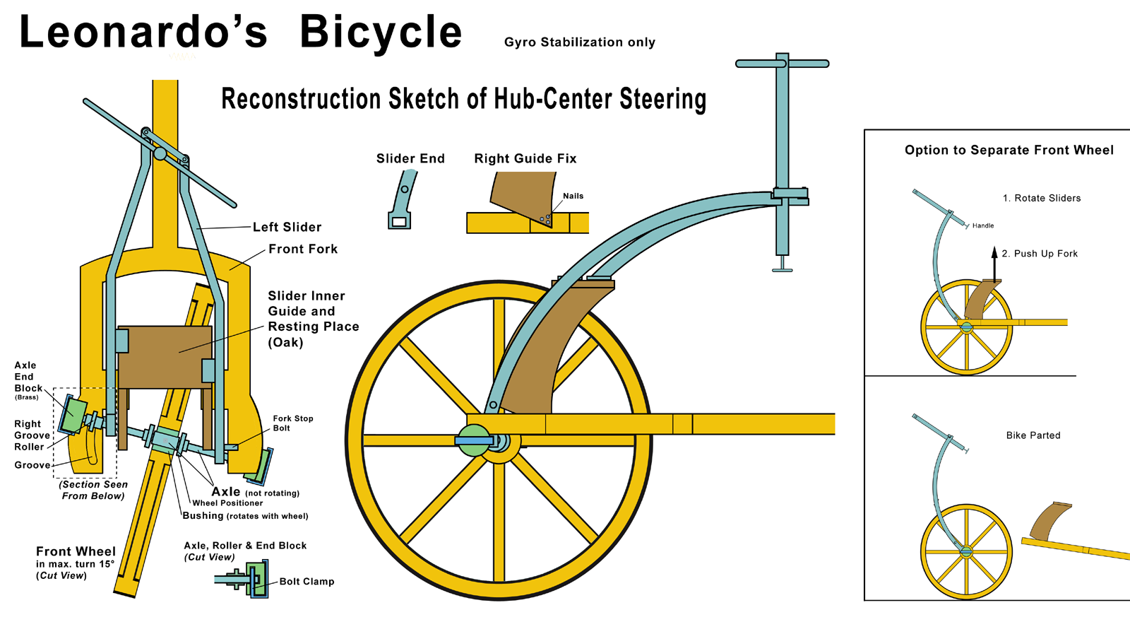
| 10:05, 28 October 2012 | Leonardo Bicycle HCS-GT.png (file) |  |
420 KB | {{Information |Description={{en|1=Reconstruction Sketch of Leonardo Bike with HCS and Gyro - Trail Stabilization.}} | Source = {{Own work}} | Author = Portolanero | Date = 2012 | Other_fields = {{Credit line |Author= http://en.wik... |
| 10:03, 28 October 2012 | Leonardo Bicycle HCS.png (file) |  |
364 KB | {{Information |Description={{en|1=Reconstruction Sketch of Leonardo Bike with HCS.}} | Source = {{Own work}} | Author = Portolanero | Date = 2012 | Other_fields = {{Credit line |Author= http://en.wikipedia.org/wiki/User%3APortolan... |
| 09:58, 28 October 2012 | Leonardo bicycle with HCS 1980-6.jpg (file) |  |
242 KB | {{Information | Description = First hub-center steering interpretation of "Leonardo's bicycle". Proof of concept vehicle by Foley, Bryant and Blessman, Purdue University, Indiana, USA, 1980. Full scale vehicle (0.5 m wheel) build and ridden by Edward ... |
| 09:56, 28 October 2012 | Leonardo bicycle with HCS 1980-5.jpg (file) |  |
244 KB | {{Information | Description = First hub-center steering interpretation of "Leonardo's bicycle". Proof of concept vehicle by Foley, Bryant and Blessman, Purdue University, Indiana, USA, 1980. Full scale vehicle (0.5 m wheel) build and ridden by Edward ... |
| 09:55, 28 October 2012 | Leonardo bicycle with HCS 1980-4.jpg (file) |  |
246 KB | {{Information | Description = First hub-center steering interpretation of "Leonardo's bicycle". Proof of concept vehicle by Foley, Bryant and Blessman, Purdue University, Indiana, USA, 1980. Full scale vehicle (0.5 m wheel) build and ridden by Edward ... |
| 09:54, 28 October 2012 | Leonardo bicycle with HCS 1980-3.jpg (file) |  |
263 KB | {{Information | Description = First hub-center steering interpretation of "Leonardo's bicycle". Proof of concept vehicle by Foley, Bryant and Blessman, Purdue University, Indiana, USA, 1980. Full scale vehicle (0.5 m wheel) build and ridden by Edward ... |
| 09:52, 28 October 2012 | Leonardo bicycle with HCS 1980-2.jpg (file) |  |
290 KB | {{Information | Description = First hub-center steering interpretation of "Leonardo's bicycle". Proof of concept vehicle by Foley, Bryant and Blessman, Purdue University, Indiana, USA, 1980. Full scale vehicle (0.5 m wheel) build and ridden by Edward ... |
| 09:51, 28 October 2012 | Leonardo bicycle with HCS 1980-1.jpg (file) |  |
228 KB | {{Information | Description = First hub-center steering interpretation of "Leonardo's bicycle". Proof of concept vehicle by Foley, Bryant and Blessman, Purdue University, Indiana, USA, 1980. Full scale vehicle (0.5 m wheel) build and ridden by Edward ... |
| 09:49, 28 October 2012 | Chains Atlanticus Madrid.jpg (file) |  |
255 KB | {{Information |Description={{en|1=The chains of Codex Atlanticus and Madrid I in context. Left a heavy chain with rounded elements to fit around a toothed wheel. The wheel would have less tooths than usual today. Below (Folio 56v-b) a chain type Mar... |
| 09:47, 28 October 2012 | Madrid I Folio 10r.jpg (file) |  |
744 KB | {{Information |Description={{en|1=The famous chain page of Codex Madrid I, folio 10r. The find was in the News 1967 as bicycle chains. In 1983 Foley, Blessman and Bryant noted the band break sketches in the lower half. }} | Source = {{PD-old-1... |
| 09:45, 28 October 2012 | Atlanticus Folio 132 133.jpg (file) |  |
701 KB | {{Information |Description={{en|1=Both sides of folio 132 and 133. The graffiti proves that both were originally one sheet. The fortress sketch on the front side of folio 133 just blocks the center of the bicycle in translucent view. Exact there Ped... |
| 09:42, 28 October 2012 | Atlanticus Folio 133v.jpg (file) |  |
252 KB | {{Information |Description={{en|1=A color photo of folio 133v shows the bike be fainter than the graffiti. }} | Source = {{PD-old-100}} | Author = Salai and an other pupil of Leonardo da Vinci | Date = 1493 | Other_fields = {{Cr... |
| 09:40, 28 October 2012 | Pedretti Folio 133v.jpg (file) |  |
115 KB | {{Information |Description={{en|1=The line sketch published 1978 by Carlo Pedretti about his pre find in 1961. It is here mirrored and overlaid on folio 133v. The good fit suggest it is a redraw with over 10 year old memory after he lost his notes i... |
| 09:39, 28 October 2012 | Leonardo Folio 133v Bicycle.jpg (file) |  |
230 KB | {{Information |Description={{en|1=The famous bicycle sketch in Leonardo's Codex Atlanticus. }} | Source = {{PD-old-100}} | Author = Leonardo da Vinci | Date = 1493 | Other_fields = {{Credit line |Author=http://en.wikipedia.org/... |
| 09:37, 28 October 2012 | Drebbel-Clock.jpg (file) |  |
676 KB | {{Information |Description={{en|1=The barometric clock of Cornelis Drebbel patented in 1598 and then known as "perpetuum mobile". Print by Hiesserle von Choda (1557-1665). }} | Source = {{PD-old-100}} | Author = Hiesserle von Choda | ... |
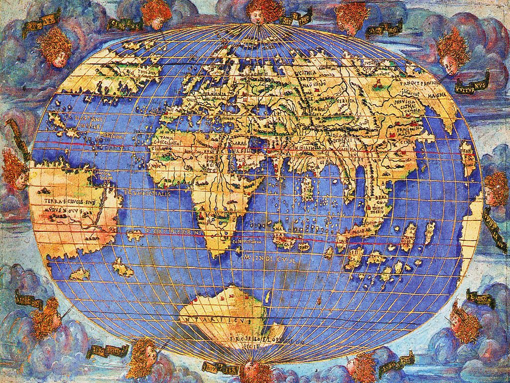
| 09:32, 28 October 2012 | Leonardo da Vinci Globe Gores.png (file) |  |
285 KB | {{Information |Description={{en|1=The c. 1514 globe gores of Leonardo with the first right positioned and sized Antarctica and one of the firsts with "America". Royal Collections of Windsor Castle, London. }} | Source = {{PD-old-100}} | Aut... |
| 09:30, 28 October 2012 | Leonardo Ballistic Trajectory.png (file) |  |
335 KB | {{Information |Description={{en|1=The parabola as ballistic trajectory by Leonardo was centuries ahead of his time. }} | Source = {{PD-old-100}} | Author = Leonardo and others | Date = pre 1700 | Other_fields = {{Credit line |A... |
| 16:26, 3 October 2012 | Femgericht und inquisition 1889.pdf (file) |  |
3.32 MB | {{Information |Description={{en|1=Thudichum, Friedrich: Femgericht und Inquisition (Giessen 1889) Main source on the Secret Courts by a German professor of law at Tübingen. In German and old German letters. }} | Source = {{PD-old-100}} | Autho... |
| 11:25, 14 December 2011 | Marinus of Tyre Pinax.png (file) |  |
1.13 MB | {{Information |Description={{en|1=A reconstruction of a Marinus of Tyre like Pinax according Ptolemy and Nordenskioeld. Three wood panel were covered with a parchment map of the world. }} | Source = {{Own work}} | Author = Portolanero | Date |
| 11:21, 14 December 2011 | Antarctica 1531-Modern Tracks.png (file) |  |
900 KB | {{Information |Description={{en|1=The Hapgood transformation of Antarctica by Oronce Fine 1531 and a modern map. Further the extension of the last glaciation maximum and the tracks of some of the most famous South Pole expeditions. }} | Source = {{O |
| 11:18, 14 December 2011 | Antarctica 1531-Modern.png (file) |  |
756 KB | {{Information |Description={{en|1=The Hapgood transformation of Antarctica by Oronce Fine 1531 and a modern map overlay }} | Source = {{Own work}} | Author = Portolanero | Date = 2011 | Other_fields = {{Credit line |Author = http://en. |
| 11:15, 14 December 2011 | Pinax-Drake Passage.jpg (file) |  |
638 KB | {{Information |Description={{en|1=The Pinax offers an explanation for the missing of the Drake passage and the Antarctic peninsula. The Fine Antarctic had to be from a polar projection. The only place for such a map was on the front side of the closed pi |
| 11:12, 14 December 2011 | Oronce Fine 1531.jpg (file) |  |
1.31 MB | {{Information |Description={{en|1=The famous and extraordinary 1531 world map by the French scientist Oronce Fine. It is the first(?) Greenland as an island and the most detailed Antarctica. }} | Source = {{PD-old-100}} | Author = Oronce Fi |
| 11:08, 14 December 2011 | Rosselli 1508.jpg (file) |  |
397 KB | {{Information |Description={{en|1=The first depiction of Antarctica on a c. 1508 world map of the Florence artist Francesco Rosselli. The cartographic data was probably by Henricus Martellus Germanus. }} | Source = {{PD-old-100}} | Author = |
| 11:06, 14 December 2011 | Sebastian Muenster 1544.jpg (file) |  |
1.19 MB | {{Information |Description={{en|1=World map of 1544 by the German scientist Sebastian Muenster. Alaska and Canada have similarities with the Wytfliet atlas of 1597. }} | Source = {{PD-old-100}} | Author = Sebastian Muenster | Date = |
| 11:02, 14 December 2011 | Alaska 1597.jpg (file) |  |
1.04 MB | {{Information |Description={{en|1=Left a map of Alaska over a century before the official discovery. From the Wytfliet atlas of 1597. Right the same area on a modern map. }} | Source = {{PD-old-100}} | Author = Cornelius Wytfliet | Date |
| 10:59, 14 December 2011 | Wytfliet-1597.jpg (file) |  |
3.5 MB | {{Information |Description={{en|1=An atlas of the Americas by Cornelius Wytfliet, printed in Belgium 1597. The maps have no specific projection. The origin of the cartographic data about Alaska and parts of Canada is a mystery. }} | Source = {{PD-ol |
| 10:49, 14 December 2011 | Greenland Mercator 1569.jpg (file) |  |
509 KB | {{Information |Description={{en|1=Greenland on the Gerardus Mercator world map of 1569. The main part is based on Zeno 1558 like evident by the "Cenobium" settlement. How he got the northern coast as an island is a mystery. Later maps deteriorated the sha |
| 10:47, 14 December 2011 | Zeno 1558.png (file) |  |
373 KB | {{Information |Description={{en|1=The famous and controversial 1558 Zeno map. Claimed to be based on a map left by two ancestors 1380 in Venice. It was in 1569 superseded by Mercator. }} | Source = {{PD-old-100}} | Author = Zeno family of Ve |
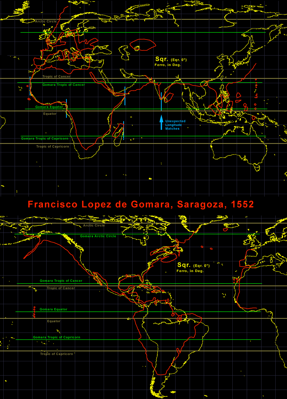
| 10:45, 14 December 2011 | Gomara-Analysis.png (file) |  |
467 KB | {{Information |Description={{en|1=Analysis of the 1552 Gomara map with a modern square projection. The grid is in 10° and based on Ferro. The results were unexpected. The fit from West Africa to India is better in longitude then in latitude. The accuracy |
| 10:43, 14 December 2011 | Gomara 1552.jpg (file) |  |
321 KB | {{Information |Description={{en|1=The "extremely rare" two part Gomara world map from the 1552 edition of his book "Hispania Victrix". It was banned in 1553 and a search on all copies started. The map is missing from many extant copies. It is the first ma |