Arnoldstein
Перейти к навигации
Перейти к поиску
Furlan: Arnoldstein al è un comun logât tal stât federâl austriac dale Carintie.
municipality in Villach-Land District, Carinthia, Austria   | |||||
| Медиафайл | |||||
| Это частный случай понятия |
| ||||
|---|---|---|---|---|---|
| Местонахождение | Филлах, Каринтия, Австрия | ||||
| Численность населения |
| ||||
| Площадь |
| ||||
| Высота над уровнем моря |
| ||||
| официальный сайт | |||||
 | |||||
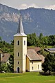
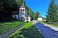
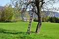
Agoritschach | Zagoriče[править]
-
 English:
Southwestern viewDeutsch:
SW-Ansicht -
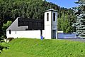
 English:
Lutheran parish church A. B.Deutsch:
evangelische Pfarrkirche A. B. -

-
 English:
Lutheran cemetery with chapelDeutsch:
Evangelischer Friedhof mit Kapelle


Arnoldstein | Podklošter[править]
Marktplatz[править]
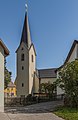
Parish church Saint Lambert | Pfarrkirche hl. Lambert[править]
-
 English:
Southwestern viewDeutsch:
SW-Ansicht -
 English:
Southwestern viewDeutsch:
SW-Ansicht -
 English:
Northeastern viewDeutsch:
NO-Ansicht -
 English:
Northern viewDeutsch:
Nord-Ansicht -
 English:
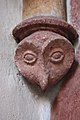
Relief of coat of arms of an abbot at the exterior wallDeutsch:
Wappenreliefstein eines Abtes an der Außenwand -
 English:
Stone relief of abbot Thomas Steyerberger at the western exterior steeple wallDeutsch:
Steinrelief des Abtes Thomas Steyerberger an der westlichen Außenwand des Turms -
 English:
Stone relief of abbot Benedikt Traxler (1553) at the exterior wallDeutsch:
Steinrelief des Abtes Benedikt Traxler (1553) an der Außenwand -
 English:
Epitaph (1534) at the exterior wallDeutsch:
Epitaph (1534) an der Außenwand -
 English:
War memorialDeutsch:
Kriegerdenkmal


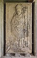
Roman stone relief with a couple | Römischer Nischenportraitgrabstein mit Büsten eines Ehepaares[править]
-
 English:
Northern viewDeutsch:
Nord-Ansicht

Klosterweg[править]
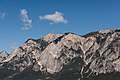
View at the Dobratsch mountain | Blick auf den Dobratsch[править]
-
 English:
Southern view at the Dobratsch mountainDeutsch:
Süd-Ansicht des Dobratsch -
 English:
Southern view at the Dobratsch mountainDeutsch:
Süd-Ansicht des Dobratsch


#1: Roman Catholic rectory | Nr. 1: Röm.-kath. Pfarramt[править]
-
 English:
Eastern viewDeutsch:
Ost-Ansicht -
 English:
Eastern viewDeutsch:
Ost-Ansicht


#2: Museum of local history | Nr. 2: Heimatmuseum[править]
-
 English:
Southeastern viewDeutsch:
SO-Ansicht -
 English:
Southeastern viewDeutsch:
SO-Ansicht -
 English:
Southeastern viewDeutsch:
SO-Ansicht -
 English:
Southeastern viewDeutsch:
SO-Ansicht -
 English:
Concession of market rights by emperor Ferdinand I.Deutsch:
Verleihungurkunde über das Marktrecht von Kaiser Ferdinand I.


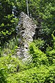
Ruin of the Benedictine monastery | Ruine des Benediktinerklosters[править]
-
 English:
Southern view, Dobratsch in the backgroundDeutsch:
Süd-Ansicht, Dobratsch im Hintergrund -
 English:
Western viewDeutsch:
West-Ansicht -
 English:
Western viewDeutsch:
West-Ansicht -
 English:
Southeastern viewDeutsch:
SO-Ansicht -
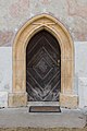
 English:
Western portalDeutsch:
Portal im Westen -
 English:
Western portalDeutsch:
Portal im Westen -
 English:
Stone relief on top of the portal of the monastery ruinDeutsch:
Reliefstein über dem Eingang der Klosterruine -
 English:
Oil painting around 1870Deutsch:
Ölbild von 1870 -
 English:
Monastery ruinDeutsch:
Klosterruine -
 English:
Church interior of the monastery church Saint George within the ruinDeutsch:
Kirchenraum der Klosterkirche Heiliger Georg innerhalb der Ruine -
 English:
Heightened choir of the monastery church Saint George within the ruinDeutsch:
Erhöhter Chor der Klosterkirche Heiliger Georg innerhalb der Ruine -
 English:
Crypt of the monastery church inside the ruinDeutsch:
Krypta der Stiftskirche in der Klosterruine -
 English:
Crypt of the monastery church inside the ruinDeutsch:
Krypta der Stiftskirche in der Klosterruine -
 English:
Monastery (around 1880)Deutsch:
Benediktinerstift (um 1880) -
 English:
Plaque as acknowledgement of gratitude for the “Revitalization Association of the monastery ruin" and it`s chairman Bernhard Wolfsgruber inside the friary ruinDeutsch:
Inschrifttafel als Anerkennung gegenüber dem „Revitalisierungsverein Klosterruine“ und seinem Obmann Bernhard Wolfsgruber in der Klosterruine -
 English:
Chairman Bernhard WolfsgruberDeutsch:
Obmann Bernhard Wolfsgruber


Municipal office | Marktgemeindeamt[править]
-
 English:
Municipal officeDeutsch:
Marktgemeindeamt

Cross chapel | Kreuzkapelle[править]
-
 English:
Cross chapel and wayside chapel over a brookDeutsch:
Kreuzkapelle und Wegkapelle über einem Bach -
 English:
Cross chapel and wayside chapel over a brookDeutsch:
Kreuzkapelle und Wegkapelle über einem Bach -
 English:
Cross chapel and wayside chapel over a brookDeutsch:
Kreuzkapelle und Wegkapelle über einem Bach -
 English:
Cross chapel and wayside chapel over a brookDeutsch:
Kreuzkapelle und Wegkapelle über einem Bach


Miscellaneous | Diverses[править]
-
 English:
MarktstrasseDeutsch:
Marktstraße -
 English:
Wayside chapel on the MarktstrasseDeutsch:
Wegkapelle an der Marktstraße -
 English:
Lutheran resurrection churchDeutsch:
Evangelische Auferstehungskirche -
 English:
Elementary schoolDeutsch:
Volksschule -
 English:
Memorial stone for October 10th, 1920 on the west wall of the elementary schoolDeutsch:
Gedenkstein zum 10. Oktober 1920 an der Westwand der Volksschule -
 English:
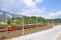
Bridge of the Nussallee and freight trainsDeutsch:
Brücke der Nussallee und Güterzüge im Bahnhofsbereich -
 English:
Nussallee #12: Residential building for several families "Drauland"Deutsch:
Nussallee 12: Mehrfamilienwohnhaus „Drauland“ -
 English:
Nussallee #12: Residential building for several families "Drauland"Deutsch:
Nussallee 12: Mehrfamilienwohnhaus „Drauland“ -
 English:
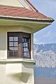
Nussallee #12: South east bay window at the residential building for several families "Drauland"Deutsch:
Nussallee 12: Südöstliches Eck-Erkerfenster am Mehrfamilienwohnhaus „Drauland“ -
 English:
Nussallee #12: South west bay window at the residential building for several families "Drauland"Deutsch:
Nussallee 12: Südwestliches Eck-Erkerfenster am Mehrfamilienwohnhaus „Drauland“ -
 English:
Nussallee #12: Eastern dormer window on the residential building for several families "Drauland"Deutsch:
Nussallee 12:Östliche Dachgaupe am Mehrfamilienwohnhaus „Drauland“ -
 English:
Nussallee #12: Western dormer window on the residential building for several families "Drauland"Deutsch:
Nussallee 12:Westliche Dachgaupe am Mehrfamilienwohnhaus „Drauland“ -
 English:
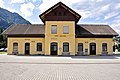
Train stationDeutsch:
Aufnahmsgebäude des Bahnhofs -
 English:
Train station with railway tracksDeutsch:
Zugbahnhof mit Gleisanlagen -
 English:
Train station with railway tracksDeutsch:
Zugbahnhof mit Gleisanlagen -
 English:
Freight trains at the station areaDeutsch:
Güterzüge im Bahnhofsbereich -
 English:
Main fire stationDeutsch:
Hauptfeuerwache


Erlendorf | Oljše[править]
Gailitz | Ziljica[править]
-
 English:
Number 1: Cemetery with three chapelsDeutsch:
Nummer 1: Friedhof mit drei Kapellen -
 English:
View from the cemetery at the DobratschDeutsch:
Blick vom Friedhof auf den Dobratsch -
 English:
Shot-towerDeutsch:
Schrotturm -
 English:
Shot-towerDeutsch:
Schrotturm -
 English:
Shot-towerDeutsch:
Schrotturm -
 English:
Subsidiary church Saints Mary and PeterDeutsch:
Filialkirche Heilige Maria und Petri -
 English:
Bridge across the river GailitzDeutsch:
Brücke über die Gailitz


Greuth | Rute[править]
-
 English:
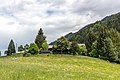
Number 1: Former forester`s lodgeDeutsch:
Nummer 1: Ehemaliges Forsthaus -
 English:
Place of the late antique hill-top settlement on top of the “Hoisch hill”Deutsch:
Platz der spätantiken Höhensiedlung Hoischhügel -
 English:
Catwalk across the Klaus brookDeutsch:
Fußsteg über den Klausbach


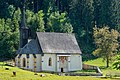
Hart | Ločilo[править]
-
 English:
Subsidiary church Saint AnnaDeutsch:
Filialkirche Heilige Anna -
 English:
Painting of Saint Christopher on the south wall of the subsidiary church Saint AnnaDeutsch:
Fresko des Heiligen Christophorus an der Süd-Wand der Filialkirche Heilige Anna -
 English:
Alcove wayside shrineDeutsch:
Nischen-Bildstock


Krainberg | Strmec[править]
View of Fürnitz and Villach | Blick auf Fürnitz und Villach[править]


Miscellaneous | Diverses[править]
-
 English:
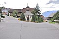
Building on Wurzenpassstraße #1Deutsch:
Gebäude an der Wurzenpassstraße 1 -
 English:
Signs on WurzenpassstraßeDeutsch:
Verkehrsschilder an der Wurzenpassstraße -
 English:
Signs on WurzenpassstraßeDeutsch:
Verkehrsschilder an der Wurzenpassstraße -
 English:
SignpostDeutsch:
Wegweiser -
 English:
Placename signDeutsch:
Ortsschild -
 English:
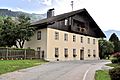
Residential building in Krainberg #2Deutsch:
Wohnhaus in Krainberg 2 -
 English:
Western viewDeutsch:
West-Ansicht -
 English:
Western viewDeutsch:
West-Ansicht -
 English:
Western viewDeutsch:
West-Ansicht -
 English:
Western viewDeutsch:
West-Ansicht -
 English:
Western viewDeutsch:
West-Ansicht -
 English:
Traditional farmhouseDeutsch:
Traditionelles Bauernhaus -
 English:
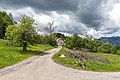
Local roadDeutsch:
Lokalstraße -
 English:
Crucifix near the road chapel Maria HilfDeutsch:
Kruzifix nahe der Wegkapelle Maria Hilf


Road chapel Maria Hilf | Kapelle Maria Hilf[править]
-
 English:
Southern viewDeutsch:
Süd-Ansicht -
 English:
Southern viewDeutsch:
Süd-Ansicht -
 English:
Northern viewDeutsch:
Nord-Ansicht -
 English:
Northern viewDeutsch:
Nord-Ansicht -
 English:
Northern viewDeutsch:
Nord-Ansicht -
 English:
Northwestern viewDeutsch:
NW-Ansicht


Wurzenpass[править]
-
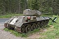
 English:
T34 on the Wurzenpass RoadDeutsch:
T34 an der Wurzenpass-Strasse -
 English:
T34 on the Wurzenpass RoadDeutsch:
T34 an der Wurzenpass-Strasse -
 English:
T34 on the Wurzenpass RoadDeutsch:
T34 an der Wurzenpass-Strasse


Krainegg | Podkrajnik[править]
-
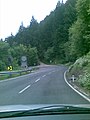 English:
Strong incline of the Wurzenpass RoadDeutsch:
Starkes Gefälle der Wurzenpass-Strasse

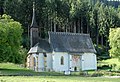
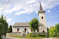
Lind | Lipa[править]
-
 English:
Subsidiary church Saint Steven and cemeteryDeutsch:
Filialkirche Heiliger Stefan und Friedhof

Maglern | Megvarje[править]
-
 English:
View from the Hoischhuegel at Hohenthurn and Meclaria/MaglernDeutsch:
Blick vom Hoischhügel auf Hohenthurn und Meclaria/Maglern -
 English:
Flor plan of uins of castle StrassfriedDeutsch:
Grundriss der Burgruine Strassfried -
 English:
Keep of the ruins of castle StrassfriedDeutsch:
Bergried der Burgruine Strassfried -
 English:
Ruins of castle StrassfriedDeutsch:
Burgruine Strassfried -
 English:
Ground plan of an archaeological site in "Meclaria"Deutsch:
Grundriss einer Notgrabung in „Meclaria“ -
 English:
Long village along the ancient Roman roadDeutsch:
Reihendorf entlang der alten Römerstraße -
 English:
Number 1: Castle Strassfried, west drivewayDeutsch:
Nummer 1: Schloss Strassfried, West-Einfahrt -
 English:
Number 1: Castle Strassfried, west viewDeutsch:
Nummer 1: Schloss Strassfried, West-Ansicht -
 English:
Number 1: Castle StrassfriedDeutsch:
Nummer 1: Schloss Strassfried -
 English:
Number 1: Stable`s stone wall of the new castle StrassfriedDeutsch:
Nummer 1: Steinmauer des Stallgebäudes von Schloss Strassfried -
 English:
Administrator`s farmhouse ruin of castle StrassfriedDeutsch:
Meierhof-Ruine von Schloss Strassfried -
 English:
Administrator`s farmhouse ruin of castle Strassfried, south viewDeutsch:
Meierhof-Ruine von Schloss Strassfried, Süd-Ansicht -
 English:
Corridor in the administrator`s farmhouse ruin of castle StrassfriedDeutsch:
Erdgeschoßflur („Labn“) der Meierhof-Ruine von Schloss Strassfried -
 English:
Long village along the ancient Roman roadDeutsch:
Reihendorf entlang der alten Römerstraße -
 English:
Ancient Roman road with pasture gate and wooden fountain east of MaglernDeutsch:
Alte Römerstraße mit Weide-Gatter und Holzbrunnen östlich von Maglern -
 English:
Ancient Roman road with wooden fountain east of MaglernDeutsch:
Alte Römerstraße mit Holzbrunnen östlich von Maglern -
 English:
Fountain on the ancient Roman road east of MaglernDeutsch:
Holzbrunnen an der alten Römerstraße östlich von Maglern -
 English:
Ancient Roman road with pasture ground east of MaglernDeutsch:
Alte Römerstraße mit Weideland östlich von Maglern -
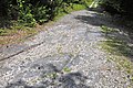 English:
Lane grooves on the ancient Roman road in the Maglern forestDeutsch:
Eingemeißelte Spurrillen auf dem römerzeitlichen Straßenzug im Maglerner Wald -
 English:
Lane grooves on the ancient Roman road in the Maglern forestDeutsch:
Eingemeißelte Spurrillen auf dem römerzeitlichen Straßenzug im Maglerner Wald -
 English:
Gailitz riverDeutsch:
Gailitz Fluss -
 English:
Gailitz river in front of a weirDeutsch:
Gailitz Fluss vor einem Wehr -
 English:
Gailitz river in front of a weirDeutsch:
Gailitz Fluss vor einem Wehr


Neuhaus an der Gail | Poturje[править]
-
 English:
View from the Thurnberg chapel in eastern directionDeutsch:
Blick von der Thurnbergkapelle in östliche Richtung -
 English:
View from the Thurnberg at the railway station of the Rudolfsbahn IVDeutsch:
Blick vom Thurnberg auf den Bahnhof der Rudolfsbahn IV -
 English:
Subsidiary church Saint Nicholas and cemeteryDeutsch:
Filialkirche Heiliger Nikolaus und Friedhof -
 English:
Thurnberg chapel (former Nicholas church)Deutsch:
Thurnbergkapelle (ehemalige Nikolauskirche) -
 English:
Stone wall encircling the Thurnberg chapel (former Nicholas church)Deutsch:
Befestigungsanlage rings um die Thurnbergkapelle (ehemalige Nikolauskirche) -
 English:
Thurnberg chapel (former Nicholas church)Deutsch:
Thurnbergkapelle (ehemalige Nikolauskirche) -
 English:
Frescos inside the Thurnberg chapel (former Nicholas church)Deutsch:
Fresken in der Thurnbergkapelle (ehemalige Nikolauskirche) -
 English:
Stone wall encircling the chapel at ThurnbergDeutsch:
Befestigungsanlage rings um die Kapelle in Thurnberg -
 English:
Landscape on the ThurnbergDeutsch:
Landschaft am Thurnberg -
 English:
Vineyard on the ThurnbergDeutsch:
Weinberg am Thurnberg -
 English:
Railway line Rudolfsbahn IVDeutsch:
Eisenbahnstrecke Rudolfsbahn IV


Oberthörl | Zgornja Vrata[править]
Pöckau | Peče[править]
-
 English:
Subsidiary church Saint Ruprecht and cemeteryDeutsch:
Filialkirche Heiliger Ruprecht und Friedhof -
 English:
Interior of the subsidiary church Saint RuprechtDeutsch:
Innenraum der Filialkirche Heiliger Ruprecht -
 English:
Baroque high altar in the subsidiary church Saint RuprechtDeutsch:
Barocker Hochaltar in der Filialkirche Heiliger Ruprecht -
 English:
Number 28: Old residential buildingDeutsch:
Nummer 28: Altes Wohnhaus -
 English:
Number 28: Portal of the old residential buildingDeutsch:
Nummer 28: Eingang vom alten Wohnhaus


Pessendellach | Dole[править]
Radendorf | Radna vas[править]
Pilgrimage church Maria Siebenbrünn | Wallfahrtskirche Maria Siebenbrünn[править]
-
 English:
Southeastern viewDeutsch:
SO-Ansicht -
 English:
 Southeastern viewDeutsch: SO-Ansicht
 -
 English:
Eastern viewDeutsch:
Ost-Ansicht -
 English:
Eastern viewDeutsch:
Ost-Ansicht -
 English:
Eastern viewDeutsch:
Ost-Ansicht -
 English:
Northeastern viewDeutsch:
NO-Ansicht -
 English:
Northnortheastern viewDeutsch:
NNO-Ansicht -
 English:
Northern viewDeutsch:
Nord-Ansicht -
 English: Northern viewDeutsch: Nord-Ansicht
 -
 English:
Northern viewDeutsch:
Nord-Ansicht -
 English:
Eastern viewDeutsch:
Ost-Ansicht -
 English:
Eastern viewDeutsch:
Ost-Ansicht -
 English:
Gothic choir with ridge turretDeutsch:
Gotischer Chor mit Dachreiter Turm -
 English:
Gothic apseDeutsch:
Gotische Apsis -
 English: Gothic apseDeutsch: Gotische Apsis
 -
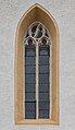
 English:
Gothic tracery windowDeutsch:
Gotisches Maßwerkfenster -
 English: Gothic church portalDeutsch: Gotisches Kirchenportal
 -
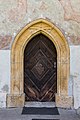
 English:
Gothic church portalDeutsch:
Gotisches Kirchenportal -
 English: Gothic tracery windowDeutsch: Gotisches Maßwerkfenster
 -
 English:
North portalDeutsch:
Nord-Portal -
 English:
Christopherus fresco on the exteriour northern wallDeutsch:
Christopherus Freske an der nördlichen Außenwand -
 English:
Christopherus fresco on the exteriour northern wallDeutsch:
Christopherus Freske an der nördlichen Außenwand -
 English:
Christopherus fresco on the exteriour northern wallDeutsch:
Christopherus Freske an der nördlichen Außenwand -
 English:
Christopherus fresco on the exteriour northern wallDeutsch:
Christopherus Freske an der nördlichen Außenwand -
 English:
Gothic rib vault at the naveDeutsch:
Kreuzrippengewölbe im Langhaus -
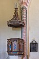 English:
Pulpit and abat-voixDeutsch:
Kanzel und Schalldeckel -
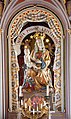
 English:
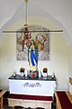
High altar figure Madonna with childDeutsch:
Madonna mit Kind „Maria Pomoc Kristjanov“ -
 English:
High altar figure Madonna with childDeutsch:
Madonna mit Kind „Maria Pomoc Kristjanov“


Miscellaneous | Diverses[править]
-
 English:
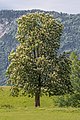
Shed and oak treeDeutsch:
Schuppen und Eichen-Baum -
 English:
Horses at a chestnut treeDeutsch:
Pferde an einem Kastanienbaum -
 English:
Blooming chestnut treeDeutsch:
Blühender Kastanienbaum -
 English:
Blooming chestnut treeDeutsch:
Blühender Kastanienbaum -
 English:
Grazing horses at a meadowDeutsch:
Grasende Pferde auf einer Weide -
 English:
HaflingerDeutsch:
Haflinger -
 English:
Electricity pylons at a landscapeDeutsch:
Hochspannungsmasten einer Landschaft -
 English:
Electricity pylons at a landscapeDeutsch:
Hochspannungsmasten einer Landschaft


Riegersdorf | Rikarja vas[править]
Miscellaneous | Diverses[править]
-
 English:
Stone arch bridgeDeutsch:
Steingewölbebrücke -
 English:
Stone arch bridgeDeutsch:
Steingewölbebrücke -
 English:
Stone arch bridgeDeutsch:
Steingewölbebrücke -
 English:
Milestone of the Kaerntner Road B83Deutsch:
Kilometerstein der Kärntner Straße B83 -
 English:
Restaurant PirtscherDeutsch:
Restaurant Pirtscher -
 English:
Restaurant PirtscherDeutsch:
Restaurant Pirtscher -
 English:
Portal of the restaurant PirtscherDeutsch:
Eingang zum Restaurant Pirtscher -
 English:
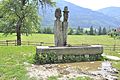
Village fountain 2003Deutsch:
Dorfbrunnen 2003 -
 English:
Milestone of the Wurzener RoadDeutsch:
Kilometerstein der Wurzener Straße -

-

-
 English:
Fortification complex ThurnbergDeutsch:
Befestigungsanlage Thurnberg -
 English:
Fortification ThurnbergDeutsch:
Befestigung Thurnberg


Wayside chapel | Riegersdorfer Kapelle[править]
-
 English:
Riegersdorf chapelDeutsch:
Riegersdorfer Wegkapelle -
 English:
Paintings of the Saints Florian, Isidor and Mauritius on the wayside chapelDeutsch:
Malereien der Heiligen Florian, Isidor und Maurizius auf der Wegkapelle -
 English:
Altar inside the Riegersdorf chapelDeutsch:
Altar in der Riegersdorfer Wegkapelle -
 English:
Riegersdorf chapelDeutsch:
Riegersdorfer Wegkapelle


St. Leonhard bei Siebenbrünn | Šentlenart pri Sedmih studencih[править]
Parish church Saint Leonard and cemetery | Pfarrkirhe hl. Leonhard und Friedhof[править]
-
 English:
Southern viewDeutsch:
Süd-Ansicht -
 English:
Southern viewDeutsch:
Süd-Ansicht -
 English:
PorchDeutsch:
Turmvorhalle -
 English:
Northern viewDeutsch:
Nord-Ansicht -
 English:
SacristyDeutsch:
Sakristei -
 English:
War memorialDeutsch:
Kriegerdenkmal -
 English:
Eastern cemetery gateDeutsch:
Östliches Friedhofstor -
 English:
Gravestone of family MerlinDeutsch:
Grabstein der Familie Merlin -
 English:
Gravestone of Ursula GanglDeutsch:
Grabstein von Ursula Gangl -
 English:
Gravestone of Johan GanglDeutsch:
Grabstein von Johan Gangl


Miscellaneous | Diverses[править]
-
 English:
Number 10: FarmhouseDeutsch:
Nummer 10: Wohnhaus

Seltschach | Sovče[править]
-
 English:
Subsidiary church Saint ServatiusDeutsch:
Filialkirche hl. Servatius -
 English:
Painting of Saint Christopher on the south wall of the subsidiary church Saint ServatiusDeutsch:
Wandbild des Heiligen Christopherus an der Süd-Wand der Filialkirche Heiliger Servatius -
 English:
Subsidiary church Saint ServatiusDeutsch:
Filialkirche hl. Servatius -
 English:
Subsidiary church Saint ServatiusDeutsch:
Filialkirche hl. Servatius -
 English:
Subsidiary church Saint ServatiusDeutsch:
Filialkirche hl. Servatius -
 English:
CemeteryDeutsch:
Friedhof


Thörl-Maglern-Greuth | Rute pri Vratih[править]
View of the Dobratsch mountain | Blick auf den Dobratsch[править]
-
 English:
Southern view at the Dobratsch mountainDeutsch:
Süd-Ansicht des Dobratsch

Parish church Saint Andrew | Pfarrkirche hl. Andreas[править]
-
 English:
North viewDeutsch:
Nord-Ansicht -
 English:
North east viewDeutsch:
Nordost-Ansicht -
 English:
North west viewDeutsch:
Nordwest-Ansicht -
 English:
North east viewDeutsch:
Nordost-Ansicht -
 English:
East viewDeutsch:
Ost-Ansicht -
 English:
South west viewDeutsch:
Südwest-Ansicht


Frescos by Thomas von Villach (1475): Tabernacle wall | Fresken von Thomas von Villach (1475): Sakramentshäuschen-Wand[править]
-
 English:
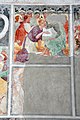
Suffering ChristDeutsch:
Leidender Christus -
 English:
Suffering ChristDeutsch:
Leidender Christus


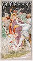
Frescos by Thomas von Villach (1475): «Living Cross» with angel choirs on the northern wall | Fresken von Thomas von Villach (1475): «Lebendes Kreuz» mit den Engelchören an der N-Wand[править]
-
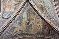
 English:
General viewDeutsch:
Gesamt-Ansicht -
 English:
General viewDeutsch:
Gesamt-Ansicht -
 English:
Cut-outDeutsch:
Ausschnitt des Zentral-Motivs


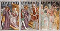
Frescos by Thomas von Villach (1475): Passion of Christ | Fresken von Thomas von Villach (1475): Leidensgeschichte Christi[править]
-
 English:
1, 2 and 3Deutsch:
1, 2 und 3 -
 English:
1: Entry into JerusalemDeutsch:
1: Einzug Christi in Jerusalem -
 English:
1: Entry into JerusalemDeutsch:
1: Einzug Christi in Jerusalem -
 English:
2: Temple incidentDeutsch:
2: Vertreibung der Händler aus dem Tempel -
 English:
2: Temple incidentDeutsch:
2: Vertreibung der Händler aus dem Tempel -
 English:
3: Christ washing the feet of the apostlesDeutsch:
3: Fusswaschung -
 English:
4, 5 and 6Deutsch:
4, 5 und 6 -
 English:
4: Christ on the Mount of OlivesDeutsch:
4: Gebet auf dem Ölberg -
 English:
5: Capture of JesusDeutsch:
5: Gefangennahme Christi -
 English:
5: Capture of JesusDeutsch:
5: Gefangennahme Christi -
 English:
6: Mocking of ChristDeutsch:
6: Verspottung Christi -
 English:
6: Mocking of ChristDeutsch:
6: Verspottung Christi -
 English:
7, 8 and 9Deutsch:
7, 8 und 9 -
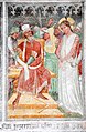
 English:
7: CaiaphasDeutsch:
7: Christus vor Kaiphas -
 English:
8: Pontius PilateDeutsch:
8: Christus vor Pilatus -
 English:
9: Flagellation of ChristDeutsch:
9: Geisselung Christi -
 English:
10, 11 and 12Deutsch:
10, 11 und 12 -
 English:
10: Crowning with ThornsDeutsch:
10: Dornenkrönung -
 English:
11: Ecce homoDeutsch:
11: Ecce homo -
 English:
12: Pilate washing his handsDeutsch:
12: Handwaschung des Pilatus -
 English:
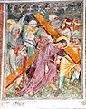
13: Bearing of the CrossDeutsch:
13: Kreuztragung -
 English:
14: Entombment of ChristDeutsch:
14: Grablegung Christi -
 English:
15: Resurrection of ChristDeutsch:
15: Auferstehung Christi -
 English:
16: Christ and doubting Saint ThomasDeutsch:
16: Christus und der ungläubige Thomas -
 English:
17: Ascension of ChristDeutsch:
17: Himmelfahrt Christi -
 English:
18: PentecostDeutsch:
18: Pfingstfest


Frescos by Thomas von Villach (1475): Choir vault endings | Fresken von Thomas von Villach (1475): Chorschluss[править]
-
 English:
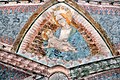
5: Madonna and ChildDeutsch:
5: Maria mit dem Jesuskind -
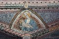 English:
5: Madonna and ChildDeutsch:
5: Maria mit dem Jesuskind -
 English:
6, 7: Angels with clavicord and portativeDeutsch:
6, 7: Engel mit Clavichord und Portativ -
 English:
8, 9: Angels with lute and fiddleDeutsch:
8, 9: Engel mit Laute und Fiedel -
 English:
12: Veil of VeronicaDeutsch:
12: Schweißtuch der Veronika -
 English:
12: Veil of VeronicaDeutsch:
12: Schweißtuch der Veronika -
 English:
13, 14: Angels with hammered dulcimer and tambourineDeutsch:
13, 14: Engel mit Hackbrett und Tamburin -
 English:
13, 14: Angels with hammered dulcimer and tambourineDeutsch:
13, 14: Engel mit Hackbrett und Tamburin -
 English:
15, 16: Angels with harp and mandolinDeutsch:
15, 16: Engel mit Harfe und Mandoline


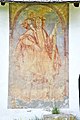
Frescos by Thomas von Villach (1475): Four Evangelists | Fresken von Thomas von Villach (1475): Vier Evangelisten[править]
-
 English:
1: Evangelist JohnDeutsch:
1: Evangelist Johannes -
 English:
1: Evangelist JohnDeutsch:
1: Evangelist Johannes -
 English:
2: Evangelist MarkDeutsch:
2: Evangelist Markus -
 English:
3: Evangelist MatthewDeutsch:
3: Evangelist Matthäus -
 English:
3: Evangelist MatthewDeutsch:
3: Evangelist Matthäus -
 English:
3: Evangelist MatthewDeutsch:
3: Evangelist Matthäus -
 English:
4: Evangelist LukeDeutsch:
4: Evangelist Lukas


Frescos by Thomas von Villach (1475): Triumphal arch | Fresken von Thomas von Villach (1475): Triumphbogen[править]
-
 English:
Last Judgment on the east wallDeutsch:
Weltgericht an der Ostwand -
 English:
Last Judgment on the east wallDeutsch:
Weltgericht an der Ostwand -
 English:
Last Judgment on the east wallDeutsch:
Weltgericht an der Ostwand -
 English:
King ChristDeutsch:
Christkönig


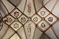
Architectural details and interior | Architektur-Details und Inneneinrichtung[править]
-
 English:
Net ribbed vault in the naveDeutsch:
Netzrippengewölbe im Langhaus -
 English:
Net ribbed vault in the naveDeutsch:
Netzrippengewölbe im Langhaus -
 English:
Net ribbed vault in the naveDeutsch:
Netzrippengewölbe im Langhaus -
 English:
1: Evangelist JohnDeutsch:
1: Evangelist Johannes -
 English:
Madonna of the RosaryDeutsch:
Rosenkranzmadonna -
 English:
Organ galleryDeutsch:
Orgelempore -
 English:
Sacraments tabernacle in the northern choir wallDeutsch:
Sakramentshäuschen in der nördlichen Chorwand -
 English:
Sacraments tabernacle in the northern choir wallDeutsch:
Sakramentshäuschen in der nördlichen Chorwand -
 English:
Left side altarDeutsch:
Linker Seitenaltar -
 English:
Right side altarDeutsch:
Rechter Seitenaltar -
 English:
GrotesqueDeutsch:
Neidkopf -
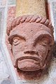 English:
GrotesqueDeutsch:
Neidkopf -
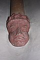
 English:
GrotesqueDeutsch:
Neidkopf -
 English:
GrotesqueDeutsch:
Neidkopf -
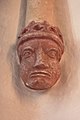
 English:
GrotesqueDeutsch:
Neidkopf -
 English:
GrotesqueDeutsch:
Neidkopf -
 English:
GrotesqueDeutsch:
Neidkopf -
 English:
GrotesqueDeutsch:
Neidkopf -
 English:
GrotesqueDeutsch:
Neidkopf -
 English:
GrotesqueDeutsch:
Neidkopf -
 English:
GrotesqueDeutsch:
Neidkopf -
 English:
GrotesqueDeutsch:
Neidkopf -
 English:
GrotesqueDeutsch:
Neidkopf -
 English:
GrotesqueDeutsch:
Neidkopf -
 English:
GrotesqueDeutsch:
Neidkopf


Tschau | Čava[править]
Miscellaneous | Diverses[править]
-
 English:
Milestone at the Wurzenpass StraßeDeutsch:
Kilometerstein an der Wurzenpass Straße -
 English:
Milestone at the Wurzenpass StraßeDeutsch:
Kilometerstein an der Wurzenpass Straße


Landscapes | Landschaften[править]
-
 English:
Staple of firewood and the Dobratsch (mountain) behindDeutsch:
Brennholzstapel und der Dobratsch dahinter -
 English:
View of the Dobratsch (mountain)Deutsch:
Blick zum Dobratsch


Wayside chapel | Wegkapelle[править]
-
 English:
Wayside chapelDeutsch:
Wegkapelle

Subsidiary church Saint Oswald with cemetery | Filialkirche hl. Oswald mit Friedhof[править]
-
 English:
Southern viewDeutsch:
Süd-Ansicht -
 English:
Southern viewDeutsch:
Süd-Ansicht


Views | Ansichten[править]
-
 English:
Southern viewDeutsch:
Süd-Ansicht -
 English:
Southern viewDeutsch:
Süd-Ansicht


Unterthörl | Spodnja Vrata[править]
-

-
 English:
Train stationDeutsch:
Aufnahmsgebäude -
 English:
Train stationDeutsch:
Aufnahmsgebäude -
 English:
Railway tracks of the train stationDeutsch:
Gleiskörper im Bahnhofsbereich -
 English:
Number 36: Residential buildingDeutsch:
Nummer 36: Zolldienst- und Wohngebäude -
 English:
Number 36: Residential buildingDeutsch:
Nummer 36: Zolldienst- und Wohngebäude


Miscellaneous | Verschiedenes[править]
-
 English:
Dreilaendereck (seen from Dobratsch)Deutsch:
Dreiländereck (Blick vom Dobratsch) -
 English:
Dreilaendereck (seen from Dobratsch)Deutsch:
Dreiländereck (Blick vom Dobratsch) -
 English:
Dreilaendereck (seen from Dobratsch)Deutsch:
Dreiländereck (Blick vom Dobratsch) -
 English:
Boundary stone for three countriesDeutsch:
Grenzstein am Dreiländereck


