Camino Inca
跳至導覽
跳至搜尋
印加帝國的公路系統   | |||||
| 上傳媒體 | |||||
| 隸屬於 |
| ||||
|---|---|---|---|---|---|
| 位置 |
| ||||
| 可分為 |
| ||||
| 文化遺產保護狀況 | |||||
| 長度 |
| ||||
| 面積 |
| ||||
 | |||||
English: Among the many roads and trails constructed in pre-columbian South America, the Inca road system of Peru was the most extensive. Traversing the Andes mountains and reaching heights of over 5,000 m (16,500 feet) above sea level, the trails connected the regions of the Inca empire from the northern provincial capital in Quito, Ecuador past the modern city of Santiago, Chile in the south. The Inca road system covered approximately 22,530 km (14,000 mi) and provided access to over three million km² of territory.
By far the most popular of the Inca trails for trekking is the Capaq Nan trail, which leads from the city of Cusco to Machu Picchu, the so-called "Lost City of the Incas".
Español: Caminos del Inca es el nombre que se les da al extenso sistema de caminos construido en el Imperio Inca. Convergen en la ciudad del Cusco, en Perú.
La más conocida de estas rutas es el llamado Camino Inca de Cusco a Machu Picchu (abreviado como Camino Inca) que se recorre a pie durante tres o cuatro días para llegar a la ciudad perdida de los Incas.
Location / Localización[編輯]
-
 English: Map of the Inca road systemEspañol: Mapa de los Caminos del Inca

Inca trail to Machu Picchu / Camino Inca a Machu Picchu[編輯]
English: By far the most popular of the Inca trails for trekking is the Capaq Nan trail, which leads from the city of Cusco to Machu Picchu, the so-called "Lost City of the Incas".
Español: La más conocida de estas rutas es el llamado Camino Inca de Cusco a Machu Picchu (abreviado como Camino Inca) que se recorre a pie durante tres o cuatro días para llegar a la ciudad perdida de los Incas.
-
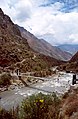 English: Start of the trail. Crossing the Urubamba river.Español: Comienzo del camino. Cruzando el Río Urubamba.
 -
 English: Llactapata ruins.Español: Ruinas de Llactapata.
 -
 English: Ascent to Warmiwanusca or Dead Woman's Pass.Español: Ascenso al Huarmihuañusca, también conocido como "Paso de la Mujer Muerta".
 -
 English: Descent from WarmiwanuscaEspañol: Descenso del Huarmihuañusca
 -
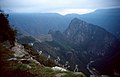
 English: Landscape with high mountainsEspañol: Paisaje de alta montaña
 -
 English: Road through the Amazon rainforest.Español: El camino a través de vegetación amazónica.
 -
 English: Road through some caves.Español: El camino a través de cuevas y pasadizos
 -
 English: Road through the Amazon rainforest.Español: El camino a través de vegetación amazónica.
 -

-
 English: First view of Machu Picchu before sunrise from Inti Punku.Español: Primera imagen de Machu Picchu antes del amanecer desde el Inti Punku.
 -
 English: People awaiting sunrise in Inti Punku before entering Machu Picchu.Español: Viajeros esperando al amanecer en el Inti Punku para poder entrar a Machu Picchu.
 -
 English: Descent to Machu Picchu from Inti PunkuEspañol: Descenso a Machu Picchu desde el Inti Punku.


Inca settlements / Asentamientos incas[編輯]
-
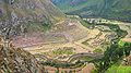 Llactapata, a ruined settlement along the Inca trail in Peru.
 -

-

-


See also / Véase también[編輯]
- More images of Inca road system in Category Inca road system / Más imágenes de los Caminos del Inca en la Categoría Caminos del Inca
- Machu Picchu