Category:1665
পরিভ্রমণে চলুন
অনুসন্ধানে চলুন
| ◀ 1660s ▶ (১৭ম শতকের, ২য় সহস্রাব্দ) |
|---|
| ◀ 1660 · 1661 · 1662 · 1663 · 1664 · 1665 · 1666 · 1667 · 1668 · 1669 ▶ |

বছর | |||||
| মিডিয়া আপলোড করুন | |||||
| নিদর্শন |
| ||||
|---|---|---|---|---|---|
| যার অংশ | |||||
| সময় |
| ||||
| পূর্বে | |||||
| পরে | |||||
| |||||
উপবিষয়শ্রেণীসমূহ
এই বিষয়শ্রেণীতে অন্তর্ভুক্ত মোট ১১টি উপবিষয়শ্রেণীর মধ্যে ১১টি উপবিষয়শ্রেণী নিচে দেখানো হয়েছে।
*
+
E
O
"1665" বিষয়শ্রেণীতে অন্তর্ভুক্ত মিডিয়া ফাইলগুলি
এই বিষয়শ্রেণীতে অন্তর্ভুক্ত মোট ১২৭টি পাতার মধ্যে ১২৭টি পাতা নিচে দেখানো হলো।
-
 1665 journal des scavans p1.png ২,৫৯২ × ৩,৫০৮; ১২৬ কিলোবাইট
-
 1665 journal des scavans p2.png ২,৫৯২ × ৩,৫০৮; ১৩৯ কিলোবাইট
-
 1665 journal des scavans title.jpg ১,১১০ × ১,৮২৭; ৫৩৭ কিলোবাইট
-
 1665 phil trans vol i title.png ১,৫১২ × ২,২৭২; ৫১৭ কিলোবাইট
-
 22 High Street, Hale date.jpg ৪,১৬৮ × ৩,৩৮৪; ৬.২৬ মেগাবাইট
-
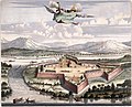
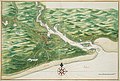
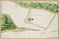
 AMH-2550-NA Ground plan of the Fort of Good Hope with the start of a new pentagon.jpg ১,৭৯২ × ২,৪০০; ৫৯৮ কিলোবাইট
-
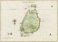
 AMH-5623-NA Map of the Malabar coast.jpg ২,৪০০ × ১,৬৬২; ৭৬২ কিলোবাইট
-
 AMH-5625-NA Map of Saldanha Bay, Table Bay, Hout Bay and False Bay.jpg ২,৪০০ × ১,৬৪৫; ৭৭৫ কিলোবাইট
-
 AMH-5626-NA Bird's eye view of the city of Judja.jpg ২,৪০০ × ১,৫৯১; ৭৯৬ কিলোবাইট
-
 AMH-5649-KB Map depicting the journey by Joan Nieuhoff from Canton to Peking.jpg ২,৪০০ × ২,০২৪; ৬৮২ কিলোবাইট
-
 AMH-6030-NA Bird's eye view of the city of Macao.jpg ৬,৯৮৫ × ৫,০০৫; ৬.৬৬ মেগাবাইট
-
 AMH-6130-NA View of Ambon.jpg ২,৪০০ × ১,৫৭৯; ৪৫৭ কিলোবাইট
-
 AMH-6132-NA Bird's eye view of the city of Atjeh.jpg ২,৪০০ × ১,৬৭৭; ৫৬৪ কিলোবাইট
-
 AMH-6133-NA View of Batticaloa.jpg ২,৪০০ × ২,০২০; ৬০৪ কিলোবাইট
-
 AMH-6134-NA Bird's eye view of the fort of Batticaloa.jpg ২,৪০০ × ১,৯৩৮; ৮৯৫ কিলোবাইট
-
 AMH-6135-NA View of Batavia.jpg ২,৪০০ × ১,৮৮৩; ৭৮৭ কিলোবাইট
-
 AMH-6143-NA Map of Table Bay.jpg ২,৪০০ × ১,৮১০; ৭২৭ কিলোবাইট
-
 AMH-6145-NA View of Canton.jpg ২,৪০০ × ১,৬৩৬; ৫১৮ কিলোবাইট
-
 AMH-6148-NA Bird's eye view of the city of Cochin, India.jpg ২,৪০০ × ১,৬৮২; ৬০২ কিলোবাইট
-
 AMH-6150-NA View of Dabul.jpg ২,৪০০ × ১,৭২৪; ৪৫৫ কিলোবাইট
-
 AMH-6151-NA View of the city of Dabul.jpg ২,৪০০ × ১,৮৪৮; ৫১০ কিলোবাইট
-
 AMH-6153-NA Bird's eye view of Negombo.jpg ২,৪০০ × ১,৮৯২; ৯০৯ কিলোবাইট
-
 AMH-6154-NA View of the city of Jaffna.jpg ২,৪০০ × ১,৬৪৯; ৬০৬ কিলোবাইট
-
 AMH-6155-NA Map of the city of Macao.jpg ২,৪০০ × ১,৭০১; ৫৮৫ কিলোবাইট
-
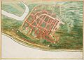
 AMH-6156-NA Map of the city of Malakka.jpg ২,৪০০ × ১,১১৩; ৩৬৮ কিলোবাইট
-
 AMH-6158-NA Picture of the Osacca castle.jpg ২,৪০০ × ১,৬৯৬; ৮৪৯ কিলোবাইট
-
 AMH-6159-NA View of Galle.jpg ২,৪০০ × ১,৭৪০; ৪০৮ কিলোবাইট
-
 AMH-6160-NA View of the city of Raiebaagh.jpg ২,৪০০ × ১,৬৫২; ৪৭৭ কিলোবাইট
-
 AMH-6161-NA Bird's eye view of the city of Samboppe, Macassar.jpg ২,৪০০ × ১,৭১৫; ৬৩৬ কিলোবাইট
-
 AMH-6162-NA Bird's eye view of the city of Samboppe, Macassar.jpg ২,৪০০ × ১,৭৫০; ৫২৪ কিলোবাইট
-
 AMH-6163-NA View of the castle of Visiapour.jpg ২,৪০০ × ১,৬২৬; ৫২০ কিলোবাইট
-
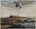
 AMH-6164-NA View of Visiapour (according to the title), depicted is Suratte.jpg ২,৪০০ × ১,৮০২; ৪৭৪ কিলোবাইট
-
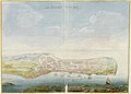
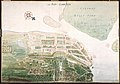
 AMH-6166-NA Bird's eye view of Colombo and environs.jpg ২,৪০০ × ১,৭১৮; ৬২০ কিলোবাইট
-
 AMH-6167-NA View of Governor's house and warehouses in front of Fort Zeelandia on Formosa.jpg ২,৪০০ × ১,৬১৬; ৫১৫ কিলোবাইট
-
 AMH-6732-NA Map of East Africa.jpg ২,৪০০ × ১,৬৫৭; ৮৬৫ কিলোবাইট
-
 AMH-6733-NA Map of the Indian Ocean.jpg ২,৪০০ × ১,৬৫৬; ৭০৮ কিলোবাইট
-
 AMH-6734-NA Map of the coast of Venezuela.jpg ২,৪০০ × ১,৬৬২; ৬৭৯ কিলোবাইট
-
 AMH-6735-NA Map of the Philippines.jpg ২,৪০০ × ১,৬৬৮; ৬৩৪ কিলোবাইট
-
 AMH-6736-NA Map of the Arabian peninsula.jpg ২,৪০০ × ১,৬৩৭; ৯৮৩ কিলোবাইট
-
 AMH-6737-NA Map of the Suratte river.jpg ২,৪০০ × ১,৬৫৭; ৭৩৫ কিলোবাইট
-
 AMH-6738-NA Map of the northern part of the Greek archipelago.jpg ২,৪০০ × ১,৬৮৬; ৪৯৭ কিলোবাইট
-
 AMH-6741-NA Map of Anjouan.jpg ২,৪০০ × ১,৫৬০; ৭২৯ কিলোবাইট
-
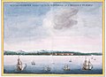
 AMH-6742-NA View of the bay at Acapulco.jpg ২,৪০০ × ১,৮৬৫; ৮৩১ কিলোবাইট
-
 AMH-6743-NA View of Arguin castle.jpg ২,৪০০ × ১,৮২০; ৪০৪ কিলোবাইট
-
 AMH-6746-NA Bird's eye view of the Baya Hondo, Venezuela.jpg ২,৪০০ × ১,৭৬০; ৫১৭ কিলোবাইট
-
 AMH-6747-NA Bird's eye view of St. Jago bay in Cuba.jpg ২,৪০০ × ১,৭০৯; ৬৫৭ কিলোবাইট
-
 AMH-6750-NA Bird's eye view of the bay near Cabo de Tiburon on Hispaniola, Haïti.jpg ২,৪০০ × ১,৭৬৮; ৫৩০ কিলোবাইট
-
 AMH-6751-NA View of the castle of Cabita.jpg ২,৪০০ × ১,৭০৯; ৩৯৮ কিলোবাইট
-
 AMH-6752-NA Bird's eye view of Groot Caymit, St. Domingo, Haïti.jpg ২,৪০০ × ১,৭৭২; ৬৩৭ কিলোবাইট
-
 AMH-6753-NA Map of Cabo Verde and environs.jpg ২,৪০০ × ১,৬৪৯; ৫১৩ কিলোবাইট
-
 AMH-6754-NA Bird's eye view of the city of Santo Domingo.jpg ২,৪০০ × ১,৭৭১; ৫০৮ কিলোবাইট
-
 AMH-6755-NA Map of the island of Goeree.jpg ২,৪০০ × ১,৭১১; ৪৯৯ কিলোবাইট
-
 AMH-6756-NA View of the island of Gouree on Cape Verde.jpg ২,৪০০ × ১,৭৮৪; ৪৫০ কিলোবাইট
-
 AMH-6758-NA Map of the island of Hispaniola (Haïti and Dominican Republic).jpg ২,৪০০ × ১,২৯৭; ৫২০ কিলোবাইট
-
 AMH-6759-NA Map of Hispaniola and Puerto Rico.jpg ২,৪০০ × ১,৬৮০; ৮১২ কিলোবাইট
-
 AMH-6761-NA Bird's eye view of the city of Loanda.jpg ২,৪০০ × ১,৭০২; ৫৩২ কিলোবাইট
-
 AMH-6762-NA View of Loanda.jpg ২,৪০০ × ১,৬০২; ৩৩১ কিলোবাইট
-
 AMH-6763-NA Bird's eye view of Manila.jpg ২,৪০০ × ১,৭২০; ৪৭৬ কিলোবাইট
-
 AMH-6764-NA Map of the bay of Manila.jpg ২,৪০০ × ১,৭১৯; ৪০০ কিলোবাইট
-
 AMH-6765-NA View of Sao Luis de Maranhao.jpg ২,৪০০ × ১,৬০৬; ৪০৮ কিলোবাইট
-
 AMH-6766-NA Map of Sao Luis de Marranhao.jpg ২,৪০০ × ১,৬৩১; ৫৭৩ কিলোবাইট
-
 AMH-6767-NA Fort Mauritius at the river of St. Francisco.jpg ২,৪০০ × ১,৬৭৭; ৩৬৪ কিলোবাইট
-
 AMH-6777-NA Map of the harbour at Pernambuco.jpg ২,৪০০ × ১,৭১৮; ৬৫৬ কিলোবাইট
-
 AMH-6778-NA View of El Mina Fort.jpg ২,৪০০ × ১,৯১৭; ৪৩৫ কিলোবাইট
-
 AMH-6780-NA Map of El Mina Fort.jpg ২,৪০০ × ১,৭৩০; ৬৬৩ কিলোবাইট
-
 AMH-6781-NA Map of the city of Mexico.jpg ২,৪০০ × ১,৮৭৩; ৭৬৬ কিলোবাইট
-
 AMH-6782-NA Floor plan of the fort of Mauritius on Rio San Francisco.jpg ২,৪০০ × ১,৬৭৭; ৫৪৭ কিলোবাইট
-
 AMH-6785-NA View of Paraiba.jpg ২,৪০০ × ১,৬৩৩; ৪০৬ কিলোবাইট
-
 AMH-6786-NA Map of the mouth of the Paraiba River.jpg ২,৪০০ × ১,৬১৩; ৬৮২ কিলোবাইট
-
 AMH-6787-NA View of Porto Calvo.jpg ২,৪০০ × ১,৬৪০; ৪৪৮ কিলোবাইট
-
 AMH-6788-NA Map of San Francisco on Santa Domingo.jpg ২,৪০০ × ১,৭৭৩; ৫৩৫ কিলোবাইট
-
 AMH-6789-NA Map of Puerto Rico.jpg ২,৪০০ × ১,৭৯৫; ৫৫৮ কিলোবাইট
-
 AMH-6790-NA View of Puerto Rico.jpg ২,৪০০ × ১,৮১৮; ৩৬১ কিলোবাইট
-
 AMH-6791-NA Map of the Powathan River.jpg ২,৪০০ × ১,৬৬২; ৭২২ কিলোবাইট
-
 AMH-6792-NA Map of the mouth of the Rio Grande and Fort Ceulen.jpg ২,৪০০ × ১,৫৯৮; ৫৫৮ কিলোবাইট
-
 AMH-6793-NA Map of the mouth of the Pousioucq River.jpg ২,৪০০ × ১,৬২৪; ৫২৩ কিলোবাইট
-
 AMH-6794-NA View of Fort Ceulen on the Rio Grande.jpg ২,৪০০ × ১,৯৬৩; ৬৩৫ কিলোবাইট
-
 AMH-6795-NA View of Keulen Fort.jpg ২,৪০০ × ১,৬২৫; ৩৩৪ কিলোবাইট
-
 AMH-6796-NA Bird's eye view of the mouth of the Senegal, Saint Louis.jpg ২,৪০০ × ১,৪৪৬; ৪৫১ কিলোবাইট
-
 AMH-6797-NA Bird's eye view of Spirito Sancto bay.jpg ২,৪০০ × ১,৭০৬; ৫৮৮ কিলোবাইট
-
 AMH-6798-NA Bird's eye view of the bay and the fort of Nieuw Vlissingen on Tobago.jpg ২,৪০০ × ১,৭৮৬; ৫০৮ কিলোবাইট
-
 AMH-6799-NA Map of the island of Tamaraca.jpg ২,৪০০ × ১,৬৬৩; ৭৮০ কিলোবাইট
-
 AMH-6800-NA Map of the island of San Thomé.jpg ৭,৩২০ × ৫,৩০৪; ৬.২৪ মেগাবাইট
-
 AMH-6801-NA Chart of Isla da Vaca near Hispaniola, Haïti.jpg ২,৪০০ × ১,৭৭২; ৫৪৮ কিলোবাইট
-
 AMH-6802-NA View of Angra on Tercera.jpg ২,৪০০ × ১,৬৪৯; ৬০০ কিলোবাইট
-
 AMH-6803-NA Bird's eye view of Mozambique island.jpg ২,৪০০ × ১,৬৮৯; ৫২৯ কিলোবাইট
-
 AMH-6804-NA Map of Olinda.jpg ২,৪০০ × ১,৬৯৭; ৬৭৭ কিলোবাইট
-
 AMH-6806-NA View of Bahia de todos os santos, All Saints bay.jpg ২,৪০০ × ১,৬৮৭; ৩৩১ কিলোবাইট
-
 AMH-6807-NA View of unidentified fort.jpg ২,৪০০ × ১,৬৪৪; ৩৩৬ কিলোবাইট
-
 AMH-6808-NA View of Goa.jpg ২,৪০০ × ১,৭২২; ৫১৪ কিলোবাইট
-
 AMH-6809-NA View of Tamaraca.jpg ২,৪০০ × ১,৬৩১; ৩১৭ কিলোবাইট
-
 AMH-6810-NA View of Calicut.jpg ২,৪০০ × ১,৭২৭; ৫২৪ কিলোবাইট
-
 AMH-6811-NA View of Porto Rico.jpg ২,৪০০ × ১,৭৫৭; ৫৬৫ কিলোবাইট
-
 AMH-6812-NA Map of countries around the North Sea.jpg ২,৪০০ × ১,৬৭৬; ৮৬৭ কিলোবাইট
-
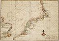
 AMH-6813-NA Map of England, the south of Ireland and part of the French coast.jpg ২,৪০০ × ১,৬৬৯; ৮৯৬ কিলোবাইট
-
 AMH-6814-NA Map of Ireland.jpg ২,৪০০ × ১,৬৬৯; ৮৪৩ কিলোবাইট
-
 AMH-7710-NA View of Fort Elmina.jpg ২,৪০০ × ১,৮৮০; ৪৯১ কিলোবাইট
-
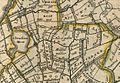
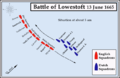 Battle of Lowestoft Map1.png ৬৪৭ × ৪১৮; ৬১ কিলোবাইট
-
 Bill of Mortality.jpg ৫০০ × ৮৩৯; ৩৫৯ কিলোবাইট
-
 Blokland1665.JPG ৭১৬ × ৫৫৩; ১১৪ কিলোবাইট
-
 Charles II as a child.jpg ২,৩৬২ × ২,৭৮০; ৬.৪৮ মেগাবাইট
-
 Dutch and Portuguese in Asia c 1665.png ৬১৭ × ৪৭৩; ৩০ কিলোবাইট
-
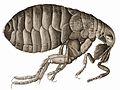
 Flea-Hooke.jpg ১,১৯৫ × ৮৮১; ৩০২ কিলোবাইট
-
 Fondamente maison 1665.JPG ২,৩০৪ × ৩,৪৫৬; ৩.৭৫ মেগাবাইট
-
 Gotha kamienica Hauptmarkt 28 2.jpg ৫,১৮৪ × ৩,৪৫৬; ৫.২৯ মেগাবাইট
-
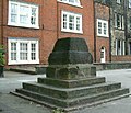 Headless cross1.jpg ৫০০ × ৪২৯; ২১ কিলোবাইট
-
 Hilarri Bustince.jpg ২,১২৪ × ১,৭১৯; ২.২৪ মেগাবাইট
-
 Hooke-bluefly.jpg ১,১৭৬ × ১,৭৮৬; ১.৯৬ মেগাবাইট
-
 HookeFlea01.jpg ১,৯৯২ × ১,৪৯৪; ১.২৮ মেগাবাইট
-
 Jan van der Heyden - The South-West Approach to the Town of Veere with the Groote Kerk.jpg ১,৫০০ × ১,২২৪; ৫৯৪ কিলোবাইট
-
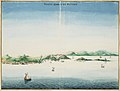
 Johannes Vingboons - D Stadt Loandas Pauli (1665).jpg ১,২৮০ × ৯০৭; ২৩৯ কিলোবাইট
-
 Johannes Vingboons - Oispito Santo (1665).jpg ১,২৮০ × ৯১০; ২৭৬ কিলোবাইট
-

-
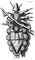 Louse diagram, Micrographia, Robert Hooke, 1667.jpg ১,১০৫ × ১,৮৫৩; ১.০৫ মেগাবাইট
-
 LowestoftMap1.png ৬৪৭ × ৪১৮; ৭৩ কিলোবাইট
-
 MaximesLaRouchefoucauld.jpg ৫৩০ × ৯৩১; ১৬৩ কিলোবাইট
-
 Micrographia title page.gif ১,০৯৮ × ১,৭৩৭; ১,০১৩ কিলোবাইট
-
 Middelpolder1665.JPG ৬২১ × ৪৩১; ৮৪ কিলোবাইট
-
 Monforte Malagon Madrid 1666.jpg ৫১৩ × ৭১৪; ২০৫ কিলোবাইট
-
 MundusSubterraneus.jpg ২,১০৪ × ২,২৪০; ১.২৩ মেগাবাইট
-
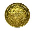 Münze Doppelte Dank-Portugalese.jpg ১,২১৫ × ১,১০৬; ২৩১ কিলোবাইট
-
 RobertHookeMicrographia1665.jpg ১,২০০ × ১,৬০০; ৯৮৫ কিলোবাইট
-
 Siegel der CAU.png ২০০ × ২৩৫; ১৫ কিলোবাইট
-
 Siegel der CAU.svg ৩৯৭ × ৪৬৩; ১৫৮ কিলোবাইট
-
 St.Oswald - Opferstock.jpg ১,৯২০ × ২,৫৬০; ২.১৩ মেগাবাইট
-
 Vermeer, Pracownia własna, 1665.jpg ২,৪৩৪ × ২,৯৬৭; ১.৪৭ মেগাবাইট
-
 Zentralbibliothek Solothurn - Der Wyniger Vertrag von 1665 - aa0834.tif ২,৪১৬ × ২,৮৬৮; ১৯.৮৬ মেগাবাইট


,_depicted_is_Suratte.jpg)


.jpg)


.jpg)
.jpg)


