Category:1987 Edgecumbe earthquake
Zur Navigation springen
Zur Suche springen
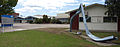
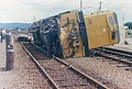
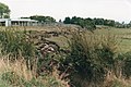
English: The 1987 Edgecumbe earthquake measured 6.5 on the moment magnitude scale and struck the Bay of Plenty region of New Zealand at 1:42 pm on 2 March.[1] The hypocentre was at a shallow depth of 8 km. The epicentre was 2.24 kilometres (1.39 mi) south-south-east of the town of Matata, and 15 kilometres (9.3 mi) north-north-west of Edgecumbe, on the Rangitaiki Plains (the floodplain of the Rangitaiki River, the Tarawera River and the Whakatane River). It was the most damaging earthquake New Zealand had experienced since the 1968 Inangahua earthquake.
Erdbeben .jpg) | |||||
| Medium hochladen | |||||
| Ist ein(e) | |||||
|---|---|---|---|---|---|
| Ort |
| ||||
| Zeitpunkt/Stand |
| ||||
 | |||||
Medien in der Kategorie „1987 Edgecumbe earthquake“
Folgende 10 Dateien sind in dieser Kategorie, von 10 insgesamt.
-
 Bay of Plenty Earthquake, 1987 (16552659081).jpg 3.734 × 2.511; 2,04 MB
-
 Edgecumbe Earthquake Memorial Stone.jpg 1.320 × 800; 531 KB
-
 Edgecumbe earthquake001.jpg 1.742 × 1.160; 299 KB
-
 Edgecumbe earthquake002.jpg 1.770 × 1.169; 330 KB
-
 Edgecumbe earthquake004.jpg 1.761 × 1.169; 396 KB
-
 Edgecumbe Fonterra Earthquake Memorial.jpg 3.303 × 1.305; 1,2 MB
-
 Edgecumbe quake005.jpg 1.171 × 1.740; 471 KB
-
 Edgecumbe quake006.jpg 1.747 × 1.174; 357 KB
-
 Edgecumbe quake008.jpg 1.761 × 1.174; 416 KB
-
 Edgecumbe quake009.jpg 1.747 × 1.174; 332 KB


