Category:2010–2011 Queensland floods
Zur Navigation springen
Zur Suche springen
English: 2010–2011 Queensland floods
Français : Inondations au Queensland (décembre 2010)
Naturkatastrophe  | |||||
| Medium hochladen | |||||
| Ist ein(e) | |||||
|---|---|---|---|---|---|
| Ort | Queensland, Australien | ||||
| Zeitpunkt/Stand |
| ||||
 | |||||
Unterkategorien
Es werden 3 von insgesamt 3 Unterkategorien in dieser Kategorie angezeigt:
In Klammern die Anzahl der enthaltenen Kategorien (K), Seiten (S), Dateien (D)
- 2011 Toowoomba flooding (36 D)
M
- Miles Floods 2010 (1 D)
Medien in der Kategorie „2010–2011 Queensland floods“
Folgende 83 Dateien sind in dieser Kategorie, von 83 insgesamt.
-
 2010 Flooding in Rockhampton Queensland.jpg 3.000 × 2.000; 3,09 MB
-
 2011 Flooding in Brisbane Suburbs.JPG 4.288 × 2.850; 2,74 MB
-
 2011 Floods Lowood.jpg 4.320 × 3.240; 1,79 MB
-
 4WD crosses rising Boyne River east of Durong.jpg 4.352 × 2.448; 9,44 MB
-
 A flooded road in Ipswich.jpg 4.146 × 3.018; 5,18 MB
-
 A flooded street in Brassall, Ipswich 1.jpg 4.288 × 3.216; 1,9 MB
-
 A flooded street in Brassall, Ipswich 2.jpg 4.288 × 3.216; 1,88 MB
-
 A flooded street in Brassall, Ipswich 3.jpg 4.288 × 3.216; 2,85 MB
-
 A flooded street in Brassall, Ipswich.jpg 4.268 × 3.190; 6,05 MB
-
 Boyne River cuts Mundubbera-Durong Road.jpg 4.352 × 2.448; 10,2 MB
-
 Bremer River in flood in Ipswich.jpg 1.024 × 576; 401 KB
-
 Bremer river in flood, still rising, 6-00pm 11-01-11.jpg 1.024 × 768; 283 KB
-
 Bremer River in flood.jpg 1.024 × 576; 205 KB
-
 Brisbane businesses sand bagged in preparation of the predicted flooding.jpg 1.024 × 480; 233 KB
-
 Brisbane flood, 2011 - panoramio.jpg 3.932 × 1.056; 1,27 MB
-
 Brisbane River Downstream From Wivenhoe Dam 2010 While Spillway Is Open.JPG 2.592 × 1.944; 2,35 MB
-
 Brisbane River in flood.jpg 2.048 × 1.536; 467 KB
-
 Brisbane Street in Ipswich flooded.jpg 1.024 × 768; 332 KB
-
 Brisbane Valley Highway during 2011 floods.jpg 4.320 × 3.240; 5,81 MB
-
 Burnett River in flood.jpg 4.352 × 2.448; 8,81 MB
-
 Burnett River in flood2.jpg 4.352 × 2.448; 7,15 MB
-
 CalliopeRiverInFlood-QueenslandDec2010.jpg 1.469 × 1.102; 800 KB
-
 Car stuck the flooded Union Drive in the Brisbane suburb of Highgate Hill.jpg 4.272 × 2.848; 1,66 MB
-
 Caravan floating in the flooded Ipswich of Gailes.jpg 3.056 × 2.035; 1,11 MB
-
 Churchill Drive flooded in Warwick.jpg 2.592 × 1.944; 882 KB
-
 Coles supermarket in Brisbane Street flooded.jpg 1.024 × 768; 385 KB
-
 Colleges Crossing Flooded-11.jpg 4.608 × 3.072; 10,84 MB
-
 Colleges Crossing Flooded-12.jpg 3.072 × 4.608; 10 MB
-
 Colleges Crossing Flooded-13.jpg 4.608 × 3.072; 10,31 MB
-
 Colleges Crossing Flooded-14.jpg 4.608 × 3.072; 11,66 MB
-
 Colleges Crossing Flooded-15.jpg 4.608 × 3.072; 11,08 MB
-
 Colleges Crossing Flooded-3.jpg 4.608 × 3.072; 8,98 MB
-
 Colleges Crossing Flooded-4.jpg 4.608 × 3.072; 12,28 MB
-
 Colleges Crossing Flooded-5.jpg 4.608 × 3.072; 10,86 MB
-
 Colleges Crossing Flooded-7.jpg 4.608 × 3.072; 11,44 MB
-
 Colleges Crossing underwater at Chuwar.jpg 2.048 × 1.536; 2,4 MB
-
 Corner Brisbane and East streets in Ipswich flooded.jpg 1.024 × 768; 382 KB
-
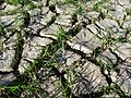 CSIRO ScienceImage 11453 Silt deposited from the 2011 Queensland floods.jpg 2.657 × 1.993; 4,42 MB
-
 CSIRO ScienceImage 11454 Footprints in silt deposited from the 2011 Queensland floods.jpg 2.657 × 1.993; 5,25 MB
-
 CSIRO ScienceImage 11455 Silt deposited from the 2011 Queensland floods.jpg 2.657 × 1.993; 4,8 MB
-
 Damaged caravans at Gailes Caravan Village.jpg 1.280 × 648; 395 KB
-
 Dec 2010 Queensland floods.jpg 4.552 × 3.640; 3,82 MB
-
 Ellenborough Street in Ipswich underwater.jpg 1.024 × 576; 306 KB
-
 Entrance to Ipswich City Square carpark flooded.jpg 1.024 × 576; 321 KB
-
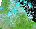
 EO-1 ALI image of the flooding in Rockhampton (close-up).jpg 720 × 480; 299 KB
-
 EO-1 ALI image of the flooding in Rockhampton.jpg 3.117 × 2.550; 2,42 MB
-
 Esk Queensland.JPG 2.816 × 2.112; 5,47 MB
-
 Flood damage and clean-up at Gailes Caravan Village.jpg 2.267 × 1.700; 1,33 MB
-
 Flood damage in Goodna.jpg 2.592 × 1.944; 1,63 MB
-
 Flooded paddock in Warwick 1.jpg 2.592 × 1.944; 734 KB
-
 Flooded paddock in Warwick.jpg 2.592 × 1.944; 650 KB
-
 Flooded road in Ipswich.jpg 1.024 × 576; 326 KB
-
 Flooded roadway in the Ipswich suburb of Gailes.jpg 3.056 × 2.035; 743 KB
-
 Flooded street in Townsville January 2010.jpg 3.456 × 2.304; 3,1 MB
-
 Flooding in Ipswich.jpg 1.024 × 576; 316 KB
-
 Flooding in the Ipswich suburb of Gailes.jpg 3.056 × 2.035; 751 KB
-
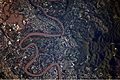
 Frog on snakes back qld floods.jpg 310 × 208; 20 KB
-
 Hancock Bridge, Bremer River, flood waters receding.jpg 1.024 × 576; 311 KB
-
 Heavy Sediment along the Queensland Coast.jpg 904 × 1.236; 466 KB
-
 House flooded in the Ipswich suburb of Gailes.jpg 3.056 × 2.035; 1,23 MB
-
 Ipswich City Square carpark flooded.jpg 1.024 × 576; 319 KB
-
 Jackie Howe Drive flooded in Warwick.jpg 2.592 × 1.944; 692 KB
-
 Limestone Street in Ipswich flooded.jpg 1.024 × 768; 409 KB
-
 Off ramp David Trumpy Bridge in Ipswich.jpg 1.024 × 576; 285 KB
-
 Paragon Street in the Brisbane suburb of Yeronga flooded.jpg 2.048 × 1.536; 1,19 MB
-
 Queens park flooded.jpg 2.592 × 1.944; 802 KB
-
 Rafting Ground Road flooded in the Brisbane suburb of Kenmore.jpg 2.048 × 1.536; 595 KB
-
 Railway line in the Ipswich suburb of Gailes.jpg 3.056 × 2.035; 1,39 MB
-
 Rockhampton in flood 2.jpg 1.204 × 904; 511 KB
-
 Rockhampton in flood 3.jpg 1.444 × 848; 626 KB
-
 Rockhampton in flood 4.jpg 1.354 × 904; 706 KB
-
 Rockhampton in flood.jpg 1.444 × 599; 182 KB
-
 Ross River flooding in Queensland 2011 a.jpg 4.000 × 3.000; 13,72 MB
-
 Ross River flooding in Queensland 2011 b.jpg 4.000 × 3.000; 5,33 MB
-
 Support our QLD flood victims.jpg 3.298 × 2.000; 983 KB
-
 Townsville flooding 2010.jpg 4.000 × 1.840; 10,01 MB
-
 Transformer flooded in Ipswich.jpg 1.024 × 576; 335 KB
-
 Victoria Street flooded in Warwick.jpg 2.592 × 1.944; 864 KB
-
 View upriver of the Brisband River from Jindalee Bridge.jpg 2.048 × 1.536; 414 KB
-
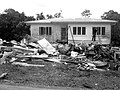
 Volunteer emergency crews help to clear debris from a house in Goodna.jpg 1.024 × 536; 197 KB
-
 Volunteers helping to clean-up the mud and damaged caused by the flood.jpg 2.567 × 721; 839 KB
-
 Wallace street bridge closed due to Condamine River in flood.jpg 2.592 × 1.944; 730 KB
-
 West Street in Ipswich underwater.jpg 1.024 × 576; 259 KB


.jpg)


