Category:2010 Pichilemu earthquake
Vai alla navigazione
Vai alla ricerca
Deutsch: Erdbeben in Pichilemu 2010
Suomi: Pichilemu maanjäristys 2010
6.9 and 7.0 MW intraplate earthquakes 2010 in Chile  | |||||
| Carica un file multimediale | |||||
| Istanza di | |||||
|---|---|---|---|---|---|
| Luogo | Pichilemu, provincia di Colchagua, regione del Libertador General Bernardo O'Higgins, Cile | ||||
| Data |
| ||||
 | |||||
File nella categoria "2010 Pichilemu earthquake"
Questa categoria contiene 23 file, indicati di seguito, su un totale di 23.
-
 2010 Pichilemu aftershock.jpg 612 × 708; 108 KB
-
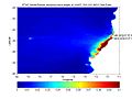
 2010 Pichilemu earthquake - tsunami travel time map.jpg 900 × 893; 156 KB
-
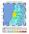
 2010 Pichilemu earthquake shakemap USGS.jpg 725 × 750; 127 KB
-
 2010PichilemuShakeMapUSGS.png 1 200 × 1 501; 1 013 KB
-
 5.7 O'Higgins earthquake.jpg 612 × 709; 108 KB
-
 Balaustrades of the Ross Park after Pichilemu earthquake.jpg 1 280 × 1 024; 764 KB
-
 House in Pichilemu, Chile, after 2010 earthquake.jpg 1 024 × 1 280; 650 KB
-
 Lolol, Chile aftershock location map.jpg 414 × 527; 72 KB
-
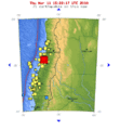 March 11 2010 aftershocks.gif 460 × 499; 36 KB
-
 March 2010 Chile earthquake intensity USGS.jpg 612 × 712; 107 KB
-
 Militaries in the La Cruz Hill.jpg 1 280 × 1 024; 127 KB
-
 People camping in La Cruz Hill.jpg 1 280 × 1 024; 264 KB
-
 People with a bonfire, in La Cruz Hill, Pichilemu.jpg 1 280 × 1 024; 145 KB
-
 Pichilemu earthquake moment amplitude graph.jpg 1 200 × 900; 207 KB
-
 Pichilemu post office demolition.jpg 1 280 × 1 024; 164 KB
-

-
 Ross Park entrance.jpg 1 280 × 836; 177 KB
-
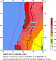 Seismic Hazard Map 2010 Pichilemu Earthquake.jpg 494 × 527; 67 KB
-
 Singer Joe Vasconcellos in La Cruz Hill.jpg 1 280 × 1 024; 132 KB
-
 Structural damage after Pichilemu earthquake, as seen in April 2011.jpg 3 648 × 2 736; 1,19 MB
-
 TemblorPichi28Nov2010.jpg 410 × 469; 66 KB
-
 Villa Los Ciruelos, Paniahue.jpg 3 068 × 1 960; 1,1 MB
-
 Wikipedia article on Pichilemu earthquake, camera perspective.jpg 3 648 × 2 736; 940 KB


