Category:Absam
Mine navigeerimisribale
Mine otsikasti
municipality in Innsbruck-Land District, Tyrol, Austria    | |||||
| Laadi fail üles | |||||
| Üksikjuht nähtusest |
| ||||
|---|---|---|---|---|---|
| Asukoht | Innsbrucki ringkond, Tirool, Austria | ||||
| Rahvaarv |
| ||||
| Pindala |
| ||||
| Kõrgus merepinnast |
| ||||
| koduleht | |||||
 | |||||
Alamkategooriad
Järgmised 15 alamkategooriat on selles kategoorias (kokku 15).
A
- Absam-Schanzen (4 P)
- Absamer Klettersteig (7 P)
B
C
F
H
- Hallerangeralm (13 P)
M
P
S
- Sculptures in Absam (4 P)
- Streets in Absam (7 P)
T
Failid kategoorias "Absam"
Järgmised 40 faili on selles kategoorias (kokku 40).
-
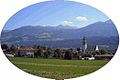 Absam (1).jpg 522 × 349; 20 KB
-
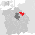 Absam im Bezirk IL.png 645 × 645; 13 KB
-
 Absam von Westen.jpg 2985 × 1820; 3,42 MB
-
 Absam, Brunnen hl. Florian2.JPG 3261 × 2024; 5,89 MB
-
 AUT Absam, Amtsschmiedhöhe 001.jpg 6768 × 2364; 5,09 MB
-
 AUT Absam, Amtsschmiedhöhe 003.jpg 4032 × 3024; 2,94 MB
-
 AUT Absam, Amtsschmiedhöhe 005.jpg 4032 × 3024; 3,22 MB
-
 AUT Absam, Amtsschmiedhöhe 006.jpg 4032 × 3024; 310 KB
-
 AUT Absam, Karl-Zanger-Strasse 002.jpg 4032 × 3024; 4,09 MB
-
 AUT Absam, Krippstrasse 004.jpg 3024 × 4032; 928 KB
-
 AUT Absam, Krippstrasse 007.jpg 3024 × 4032; 2,93 MB
-
 AUT Absam, Sankt-Marienweg 001.jpg 4032 × 3024; 2,93 MB
-
 AUT Absam, Sankt-Marienweg 002.jpg 4032 × 3024; 959 KB
-
 AUT Absam, Sankt-Marienweg 003.jpg 4032 × 3024; 3,24 MB
-
 AUT Absam, Woditschkastrasse 003.jpg 4032 × 3024; 3,35 MB
-
 Bettelwurfhütte (DSC02422).jpg 6000 × 4000; 4,37 MB
-
 Bärenbach (Urschenbach).jpg 3658 × 2355; 4,28 MB
-
 Fallbach mit Hirzer.jpg 2262 × 3378; 4,95 MB
-
 Fischleraste 1.jpg 4682 × 3272; 12,01 MB
-
 Fischleraste 2.jpg 5184 × 3575; 15,97 MB
-
 Fischleraste 3.jpg 4976 × 3481; 14,35 MB
-
 Fischleraste 4.jpg 5184 × 3888; 17,39 MB
-
 Friedhof Absam.JPG 3872 × 2592; 4,67 MB
-
 Friedhofskapelle Absam.JPG 3872 × 2592; 4,41 MB
-
 Gnadenwalder Plateau, Kellerjoch und Gilfert.jpg 3802 × 2545; 7,12 MB
-
 Innsbruck - 29-47 - Hall, Innsbruck Nordost.png 452 × 292; 388 KB
-
 Karwendel vom Largoz.jpg 4332 × 2761; 9,57 MB
-
 Kriegerdenkmal Absam.JPG 2592 × 3872; 4,32 MB
-
 Map at absam.png 400 × 240; 3 KB
-
 Mils and Absam from N.jpg 3476 × 2076; 4,48 MB
-
 Pleistozäne Sedimente am Urschenbach.jpg 2000 × 1500; 1,83 MB
-
 Rotmoos in Absam.JPG 4607 × 2998; 10,02 MB
-
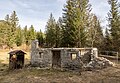
 Schaferhütte Absam.jpg 5075 × 3721; 18,62 MB
-
 Schotterwerk Absam.jpg 5184 × 3298; 12,13 MB
-
 Stieleiche an der Salzbergstraße 02.jpg 3456 × 5184; 5,2 MB
-
 Veilcheneis.jpg 3024 × 4032; 3,51 MB
-
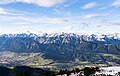
 View to Innsbruck from Hinterhorn-Alm.JPG 3872 × 2592; 6,26 MB
-
 Wald bei Gnadenwald.jpg 3845 × 2586; 2,74 MB
-
 Wappen at absam.png 166 × 192; 4 KB
-
 Wechsellagerung Sand und Schotter.jpg 2000 × 1500; 1,79 MB
.jpg)


.jpg)
.jpg)


