Category:Anacostia River
Vai alla navigazione
Vai alla ricerca
fiume degli Stati Uniti d'America   | |||||
| Carica un file multimediale | |||||
| Istanza di | |||||
|---|---|---|---|---|---|
| Luogo |
| ||||
| Lunghezza |
| ||||
| Altezza sul mare |
| ||||
| Foce |
| ||||
| Bacino di drenaggio | |||||
| Affluente |
| ||||
 | |||||
Sottocategorie
Questa categoria contiene le 20 sottocategorie indicate di seguito, su un totale di 20.
1
A
- Anacostia Railroad Bridge (9 F)
B
- Benning Bridge (6 F)
F
H
J
N
- New York Avenue Bridge (4 F)
T
W
- Whitney Young Memorial Bridge (12 F)
Y
- Yards Park bridge (12 F)
File nella categoria "Anacostia River"
Questa categoria contiene 117 file, indicati di seguito, su un totale di 117.
-
 (Water Runoff 2) 412-DSP-2-Runoff 111.jpg - DPLA - ebfc7ab275e8a76aef72e76bdfbef5ca.jpg 4 256 × 2 832; 6,18 MB
-
 1934 Benning Road Bridge.jpg 1 000 × 765; 275 KB
-
 Washington Navy Yard aerial view 1960.jpg 690 × 596; 169 KB
-

-
 428-GX-USN-1173702 (24194545480).jpg 1 899 × 1 584; 1,13 MB
-
 A fireboat shows off -a.jpg 819 × 1 024; 347 KB
-

-
 Anacostia combined sewer outflow 2018.jpg 4 608 × 3 456; 2,77 MB
-
 Anacostia Community Boathouse 001.JPG 750 × 500; 440 KB
-
 Anacostia Community Boathouse 002.JPG 750 × 500; 535 KB
-
 Anacostia Community Boathouse and Anacostia Railroad Bridge - Washington DC.jpg 2 500 × 1 255; 1,72 MB
-
 Anacostia flats - 1912-07-12.jpg 878 × 642; 275 KB
-
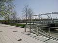
 Anacostia Park - Section D - Washington DC.jpg 2 500 × 783; 1,26 MB
-
 Anacostia Park - Section D playground - Washington DC.jpg 2 500 × 1 667; 3,5 MB
-
 Anacostia River 1936 flood.jpg 740 × 572; 188 KB
-
 Anacostia River at Heritage Island - Flickr - treegrow.jpg 4 000 × 3 000; 3,57 MB
-
 ANACOSTIA RIVER LOOKING SOUTH - NARA - 546705.jpg 3 000 × 2 013; 805 KB
-
 ANACOSTIA RIVER LOOKING WEST. ROBERT KENNEDY STADIUM ON RIGHT - NARA - 546625.jpg 3 000 × 2 020; 813 KB
-
 Anacostia River near Heritage Island - Flickr - treegrow.jpg 4 000 × 3 000; 1,96 MB
-
 Anacostia River Valley - US Army Corps of Engineers - middle portion only - 1891.jpg 5 000 × 2 022; 10,32 MB
-
 Anacostia River Washington,DC Near Kingman Island June 2017.jpg 4 032 × 3 024; 2,56 MB
-
 Anacostia River Watershed Map.png 2 550 × 3 300; 3,15 MB
-
 Anacostia River.jpg 1 944 × 2 592; 1,18 MB
-
 Anacostia waterfront panorama (7325068888).jpg 6 090 × 1 657; 1,19 MB
-
 Anacostia-near-rfk.png 774 × 932; 1,28 MB
-
 Anacostiamap.png 400 × 400; 18 KB
-
 AnacostiaRiverNE-DC-0930-062319.jpg 2 000 × 1 340; 931 KB
-
 AnacostiaRiverSE-9576-122122.jpg 1 500 × 743; 375 KB
-

-

-

-

-

-

-

-
 Bandalong Litter Trap - Anacostia River - 2019.jpg 4 032 × 3 024; 5,03 MB
-
 Bladensburg Park Pedestrian Bridge 2016.jpg 4 608 × 3 456; 3,96 MB
-
 Bladensburg Park Pedestrian Bridge deck 2016.jpg 4 608 × 3 456; 3,22 MB
-
 Bladensburg Road Bridge 2016.jpg 4 608 × 3 456; 4,26 MB
-
 Bladensburg Road Bridge deck 2016.jpg 4 608 × 3 456; 3,28 MB
-
 Bladensburg Waterfront Park, Bladensburg, Maryland 005.JPG 3 264 × 2 448; 2,03 MB
-
 Bladensburg Waterfront Park, Bladensburg, Maryland 006.JPG 3 264 × 2 448; 1,97 MB
-
 Bridge across Eastern branch of Potomac River 34794v.jpg 1 024 × 763; 394 KB
-
 Bulletin - United States National Museum (1883) (14760154826).jpg 3 686 × 1 216; 799 KB
-
 Buzzard Point Power Plant 2018 (cropped).jpg 2 611 × 1 958; 1,78 MB
-
 Buzzard Point Power Plant 2018.jpg 3 264 × 2 448; 2,24 MB
-
 BuzzardPointSW-0092-122122 (cropped).jpg 662 × 442; 238 KB
-
 BuzzardPointSW-0092-122122.jpg 1 500 × 833; 556 KB
-
 Canoeing in the Anacostia River (15011160918).jpg 500 × 333; 77 KB
-
 Capitol Hill - George Cooke, 1833 (cropped).jpg 1 254 × 474; 423 KB
-
 City of Washington from Beyond the Navy Yard by George Cooke, 1833 (cropped).jpg 1 252 × 658; 618 KB
-
 City of Washington from Beyond the Navy Yard by George Cooke, 1833.jpg 3 000 × 2 170; 3,86 MB
-
 Coastal Clean Up Volunteers. (15010938649).jpg 4 229 × 2 778; 1,92 MB
-
 DC Main Sewerage Pumping Station - South Side.jpg 1 944 × 2 592; 1,35 MB
-
 DC WASA Marine Debris Skimmer.jpg 1 927 × 2 130; 968 KB
-
 DC Water Headquarters - HQO building - 2019 (cropped).jpg 2 647 × 1 559; 2,44 MB
-
 DC Water Headquarters - HQO building - 2019.jpg 2 903 × 1 928; 2,62 MB
-
 DC Yards park and bridge 2.jpg 2 592 × 1 944; 1,28 MB
-
 DC Yards park and bridge.jpg 2 592 × 1 944; 1,71 MB
-
 Diamond Teague pier walks (6682176573).jpg 2 592 × 1 936; 1,12 MB
-
 District of Columbia LOC 87693313-19.jpg 3 690 × 3 977; 2,53 MB
-
 District of Columbia LOC 87693313-29.jpg 3 826 × 4 153; 2,22 MB
-
 District of Columbia LOC 87693313-37.jpg 3 867 × 4 122; 2,94 MB
-
 Dueling Creek MD & CSX train with containers.jpg 3 024 × 4 032; 6,32 MB
-
 Dwight Davis breaking ground for Anacostia Park - 1923-08-23.jpg 889 × 724; 330 KB
-

-

-

-

-

-

-
-
-

-
 Fort McNair aerial 2019.jpg 4 608 × 3 456; 3,47 MB
-
 GreenleafPoint.JPG 480 × 480; 92 KB
-
 Joint Base Anacostia-Bolling 2018a.jpg 3 264 × 2 448; 1,46 MB
-
 Joint Base Anacostia-Bolling 2018b.jpg 3 264 × 2 448; 1,47 MB
-
 Kingman Island Footbridge-WashingtonDC.jpg 4 032 × 3 024; 2,61 MB
-
 Kingman Island looking north from Anacostia River.jpg 4 032 × 3 024; 2,18 MB
-
 Washington Navy Yard.gif 450 × 383; 13 KB
-
 Map - Anacostia River islands.jpg 2 448 × 3 264; 2,69 MB
-
 Maps of Saint Elizabeths Hospital, Washington D.C. - 1860.tif 10 049 × 4 611; 132,59 MB
-
 Medhane Alem Eritrean Orthodox Church 01.jpg 4 028 × 1 832; 1,2 MB
-
 METRO SUBWAY CONSTRUCTION ADDS TO CITY TRAFFIC PROBLEMS - NARA - 546621.jpg 2 027 × 3 000; 1,4 MB
-
 Muriel Quackenbush LOC npcc.06530.jpg 5 335 × 4 346; 2,59 MB
-

-
 Poor House, Capitol Hill (491247537) (2).jpg 904 × 668; 135 KB
-
 POWER BOATS MOORED ON THE ANACOSTIA RIVER. SILTATION DISCOLORS THE RIVER - NARA - 547266.jpg 3 000 × 2 012; 1,04 MB
-
 RAILROAD YARDS AND ANACOSTIA RIVER. LOOKING SOUTH - NARA - 546694.jpg 3 000 × 2 024; 789 KB
-
 RAILROAD YARDS, ANACOSTIA RIVER, AND ROBERT F. KENNEDY STADIUM - NARA - 546690.jpg 2 024 × 3 000; 843 KB
-
 Rfk-from-bridge-to-kingman-lake.jpg 2 592 × 1 944; 1,68 MB
-
 RiverwalkTrail-9564-112122.jpg 1 500 × 1 080; 626 KB
-
 RiverwalkTrailSE-0447-121919.jpg 1 500 × 1 000; 517 KB
-
 Rowers on the Anacostia River in May 2014.jpg 2 500 × 970; 1,78 MB
-

-

-
 September 15, 2012 Trash collected at Anacosta River cleanup (8165198795).jpg 2 048 × 1 522; 2,05 MB
-

-
 SEWashingtonDC-0085-122122.jpg 2 000 × 1 000; 747 KB
-
 SEWashingtonDC-9808-120719.jpg 2 000 × 494; 284 KB
-
-
 THE ANACOSTIA RIVER, BROWN WITH SILT - NARA - 547214.jpg 2 904 × 1 955; 916 KB
-
-
 THE WAKE OF THE POWER BOAT ON THE ANACOSTIA RIVER IS A DIRTY BROWN - NARA - 547242.jpg 3 000 × 2 014; 753 KB
-
 The-anacostia-river-brown-with-silt-april-1973 7461333354 o.jpg 2 904 × 1 955; 468 KB
-

-

-

-

-
 Train crossing Anacostia Railroad Bridge - Washington DC.jpg 2 500 × 1 212; 1,89 MB
-
 Two male rowers on the Anacostia River with Anacostia Trail - Washington DC.jpg 2 500 × 1 325; 3,23 MB
-
 US National Arboretum from Anacostia River June 2017.jpg 4 032 × 3 024; 2,62 MB
-
 USS Trippe (DD-403) steaming down the Anacostia River on 18 July 1940 (80-G-K-14443).jpg 5 786 × 3 692; 12,42 MB
-
 WPB 1344, USCG Block Island, an Island Class 110 foot cutter.jpg 1 800 × 1 182; 553 KB
-
 Yards Park bridge (6682173521).jpg 1 936 × 2 592; 1,27 MB
-
 Yards Park.jpg 3 888 × 2 592; 4,39 MB
_412-DSP-2-Runoff_111.jpg_-_DPLA_-_ebfc7ab275e8a76aef72e76bdfbef5ca.jpg)


_southbound_over_Interstate_695_(Southeast_Freeway)_in_Washington,_D.C..jpg)
.jpg)


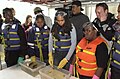
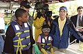
_(Department_of_Interior_officials_and_staff_joining_other)_Take_Pride_in_America_volunteers_at_the_Anacostia_River_Cleanup_event,_(sponsored_-_DPLA_-_0e4fe7d4d6c872024637d34dcd8a10a8.JPG)
_(Department_of_Interior_officials_and_staff_joining_other)_Take_Pride_in_America_volunteers_at_the_Anacostia_River_Cleanup_event,_(sponsored_-_DPLA_-_2fef39c10211a80d0bcf65be45f65dbd.JPG)
_(Department_of_Interior_officials_and_staff_joining_other)_Take_Pride_in_America_volunteers_at_the_Anacostia_River_Cleanup_event,_(sponsored_-_DPLA_-_44abf4f12936410f5c2239a6b171ab88.JPG)
_(Department_of_Interior_officials_and_staff_joining_other)_Take_Pride_in_America_volunteers_at_the_Anacostia_River_Cleanup_event,_(sponsored_-_DPLA_-_58c92bff1eb3ce73b3a82fe4c1202d91.JPG)
_(Department_of_Interior_officials_and_staff_joining_other)_Take_Pride_in_America_volunteers_at_the_Anacostia_River_Cleanup_event,_(sponsored_-_DPLA_-_756782173093a8aab17f80385418cc56.JPG)
_(Department_of_Interior_officials_and_staff_joining_other)_Take_Pride_in_America_volunteers_at_the_Anacostia_River_Cleanup_event,_(sponsored_-_DPLA_-_a2f418153ef3604dac605ec101f05777.JPG)
_(Department_of_Interior_officials_and_staff_joining_other)_Take_Pride_in_America_volunteers_at_the_Anacostia_River_Cleanup_event,_(sponsored_-_DPLA_-_d267e4a91a38cf141b6f58633ae64464.JPG)


.jpg)

.jpg)

.jpg)
.jpg)

.jpg)


.jpg)


.jpg)


_-_DPLA_-_073ca5aedcd78363604e9e5b1df7ff38.JPG)
_-_DPLA_-_5cba08b78df9d37f99f9636b58182f7e.JPG)
_-_DPLA_-_2db9f95e0fe2f7be0b4054a8ecf6c9ef.JPG)
_-_DPLA_-_1c80b8532266095addd0573d7eb9a6af.JPG)
_-_DPLA_-_96ef5c5595453503a77360dad1ac959a.JPG)
_-_DPLA_-_bfe088828b764a1781ddb809ffe69d06.JPG)
_-_DPLA_-_261d570eb84d34105f278026d73d8bac.JPG)
_-_DPLA_-_82fa3d19fc6a8ec68f37b50ef19d836e.JPG)
.jpg)


_(2).jpg)


.jpg)
.jpg)
.jpg)
.jpg)


.jpg)


_steaming_down_the_Anacostia_River_on_18_July_1940_(80-G-K-14443).jpg)

.jpg)

.jpg)
_(14760154826).jpg)
.jpg)