Category:Andreafsky River
Zur Navigation springen
Zur Suche springen
Nebenfluss des Yukon River  | |||||
| Medium hochladen | |||||
| Ist ein(e) | |||||
|---|---|---|---|---|---|
| Ort | Alaska | ||||
| Länge |
| ||||
| Mündet in | |||||
| Einzugsgebiet | |||||
 | |||||
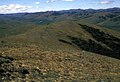
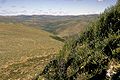
| The Andreafsky River heads from near Iprugalet Mountain, then flows southwest 120 miles to Yukon River joining it at Pitkas Point, 39 miles northwest of Marshall, Yukon-Kuskokwim Delta. Its name was reported in 1898 by U.S. Coast and Geodetic Survey (USC&GS); probably derived from the name of the nearby village. The Russians called this stream "R(eka) Nuggyklik", an Eskimo name; Captain C. W. Raymond, U.S. Army Corps Engineers, reported the name in 1869 as "Konnekova or Clear" (USGS). |
Medien in der Kategorie „Andreafsky River“
Folgende 6 Dateien sind in dieser Kategorie, von 6 insgesamt.
-
 Aerial view of the east fork of the Andreafsky river.jpg 2.100 × 1.416; 131 KB
-
 Andreafsky River AK.jpg 325 × 208; 43 KB
-
 Andreafsky river with small town.jpg 2.100 × 1.414; 136 KB
-
 St Marys AK.JPG 2.592 × 1.944; 1,22 MB
-
 Upper Andreafsky river area.jpg 2.100 × 1.430; 180 KB
-
 Upper Andreafsky River Yukon Delta NWR.jpg 1.050 × 702; 224 KB


