Category:Arafura Sea
Zur Navigation springen
Zur Suche springen
Meer zwischen Australien und Neuguinea  | |||||
| Medium hochladen | |||||
| Ist ein(e) |
| ||||
|---|---|---|---|---|---|
| Ort |
| ||||
| Fläche |
| ||||
| Zufluss |
| ||||
| Anrainerstaat | |||||
 | |||||
Unterkategorien
Diese Kategorie enthält folgende Unterkategorie:
In Klammern die Anzahl der enthaltenen Kategorien (K), Seiten (S), Dateien (D)
A
- Arafura Marine Park (8 D)
Medien in der Kategorie „Arafura Sea“
Folgende 34 Dateien sind in dieser Kategorie, von 34 insgesamt.
-
 130902-N-NZ935-034 (9674182388).jpg 3.911 × 2.794; 1,78 MB
-
-
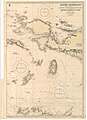
 Admiralty Chart No 1088 Arafura Sea, Published 1837.jpg 15.285 × 8.644; 39,86 MB
-
 Admiralty Chart No 942A Eastern Archipelago Sheet III, Published 1868, Corrections to 1951.jpg 11.220 × 16.434; 36,87 MB
-
 Arafura Sea (Discoveries in Australia).jpg 742 × 579; 97 KB
-
 Arafura Sea map.png 695 × 488; 186 KB
-
 Arafura-geomap.jpg 661 × 680; 142 KB
-
 Darch island, Arafura Sea, the 2 Sphinx.jpg 2.048 × 1.536; 839 KB
-
 Discoveries in Australia; (1846) (14764257502).jpg 2.182 × 1.820; 339 KB
-
 ISS006-E-23532 - View of the Arafura Sea.jpg 3.032 × 2.064; 1,22 MB
-
 ISS020-E-9881 - View of the Arafura Sea.jpg 4.256 × 2.832; 685 KB
-
 ISS020-E-9882 - View of the Arafura Sea.jpg 4.256 × 2.832; 373 KB
-
 ISS021-E-21431 - View of the Arafura Sea.jpg 3.072 × 2.040; 299 KB
-
 ISS021-E-21432 - View of the Arafura Sea.jpg 3.072 × 2.040; 267 KB
-
 ISS021-E-21433 - View of the Arafura Sea.jpg 3.072 × 2.040; 369 KB
-
 Karte Expedition Willem Jansz 1605-1606.png 1.200 × 740; 928 KB
-
 Locatie Arafurazee.PNG 484 × 362; 13 KB
-
 Oceania fantail ray (Taeniura lessoni), New Guinea.jpg 600 × 450; 156 KB
-
 Pulau Yos Sudarso Island and the Arafura Sea (MODIS 2019-09-06).jpg 1.781 × 1.335; 182 KB
-
 Queensland and British New Guinea prepared for Educational purposes.jpg 3.820 × 6.000; 5,71 MB
-
-
-

-

-

-
-

-
-

-

-

-

-
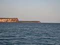
 Rocks at Imaluk Beach.jpg 1.632 × 1.224; 335 KB
-
 Tropical Storm Marcus over Arafura Sea (MODIS 2018-03-17).jpg 8.358 × 6.665; 5,06 MB
.jpg)


.jpg)


_(14764257502).jpg)


,_New_Guinea.jpg)
.jpg)

.jpg)
.jpg)
_(5987491283).jpg)
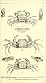
_(5988057444)_Halimede_coppingeri.jpg)
_(5988057444).jpg)
_(5988058566).jpg)
_(5987495643).jpg)
_(5988059534).jpg)
_(5988060046).jpg)
_(5987497727).jpg)
_(5987500103).jpg)
_(5988063562).jpg)

.jpg)