Category:Aust
Aller à la navigation
Aller à la recherche
village britannique | |||||
| Téléverser des médias | |||||
| Nature de l’élément | |||||
|---|---|---|---|---|---|
| Lieu | South Gloucestershire, Gloucestershire, Angleterre du Sud-Ouest, Angleterre | ||||
| Baigné par | |||||
 | |||||
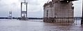
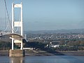
English: Aust is a small village in South Gloucestershire, England. It is near the eastern end of the Severn Bridge, which was built in 1966 to carry the M4 motorway (now the M48 motorway) over the route of the old Aust Ferry. It lies at .
Sous-catégories
Cette catégorie comprend 9 sous-catégories, dont les 9 ci-dessous.
A
- Aust Evangelical Church (4 F)
B
- Boars Head, Aust (4 F)
C
- Cake Pill (6 F)
S
- Severn powerline crossing (21 F)
- Severn View services (11 F)
- St John's church, Aust (6 F)
Média dans la catégorie « Aust »
Cette catégorie comprend 651 fichiers, dont les 200 ci-dessous.
(page précédente) (page suivante)-

-
 15mph speed limit on an Aust cycleway - geograph.org.uk - 4597051.jpg 800 × 703 ; 184 kio
-
 1997-98 Australian region cyclone season summary.png 3 630 × 2 620 ; 6,22 Mio
-
 2 new houses, Aust - geograph.org.uk - 2475142.jpg 640 × 561 ; 138 kio
-

-
 5 miles to Thornbury from Aust - geograph.org.uk - 4242411.jpg 800 × 692 ; 140 kio
-
 8 miles to Avonmouth - geograph.org.uk - 3704898.jpg 800 × 611 ; 156 kio
-
 A curving trackway just South of Aust - geograph.org.uk - 4817077.jpg 2 048 × 3 648 ; 2,44 Mio
-
 A lane near Mumbleys Farm - geograph.org.uk - 3057382.jpg 2 592 × 1 944 ; 2,12 Mio
-
 A little used footpath between Lynch Farm ^ Cote Farm - geograph.org.uk - 3495937.jpg 3 648 × 2 736 ; 4,47 Mio
-
 A pylon off Passage Road - geograph.org.uk - 2723985.jpg 800 × 600 ; 238 kio
-
 A Rhine or drainage ditch beside the farm track - geograph.org.uk - 4817079.jpg 2 048 × 3 648 ; 2,26 Mio
-
 A squat pylon, Old Passage - geograph.org.uk - 3457568.jpg 640 × 480 ; 50 kio
-
 A403 at the turning for Old Passage - geograph.org.uk - 2964957.jpg 1 024 × 475 ; 81 kio
-
 A403 heading north - geograph.org.uk - 3457552.jpg 640 × 480 ; 79 kio
-

-
 A403 junction, Aust - geograph.org.uk - 3754705.jpg 800 × 625 ; 122 kio
-
 A403 near Tanhouse Farm - geograph.org.uk - 2964967.jpg 1 024 × 663 ; 97 kio
-
 A403 towards Aust - geograph.org.uk - 4268578.jpg 800 × 430 ; 68 kio
-
 Abandoned toilet block - geograph.org.uk - 6030185.jpg 1 024 × 768 ; 287 kio
-
 Access road at Aust Cliff - geograph.org.uk - 1132368.jpg 640 × 480 ; 68 kio
-
 Access road to the Severn Bridge, Aust - geograph.org.uk - 3754708.jpg 800 × 628 ; 144 kio
-

-

-

-
 AdBlue, Severn View Services, Aust - geograph.org.uk - 4764624.jpg 800 × 556 ; 133 kio
-

-
 Amalgamated fields near Mumbleys Plat - geograph.org.uk - 2151357.jpg 640 × 426 ; 353 kio
-
 An electric pylon and the Second Severn Bridge - geograph.org.uk - 4695546.jpg 1 067 × 1 600 ; 205 kio
-
 Anglican church viewed from the east, Aust - geograph.org.uk - 3707337.jpg 600 × 800 ; 124 kio
-
 Approach to the Severn Bridge - geograph.org.uk - 862599.jpg 438 × 640 ; 60 kio
-
 Approaching Aust Services, M48 - geograph.org.uk - 3693811.jpg 640 × 430 ; 41 kio
-
 Approaching the Severn Bridge (15941352674).jpg 5 737 × 4 425 ; 10,95 Mio
-
 Approaching the Severn Bridge - geograph.org.uk - 4834162.jpg 1 600 × 1 067 ; 248 kio
-
 Aust , Grassy Field ^ Aust Village - geograph.org.uk - 2806031.jpg 4 288 × 2 848 ; 5,31 Mio
-
 Aust , Old Petrol Pumps - geograph.org.uk - 2806043.jpg 4 288 × 2 848 ; 6,73 Mio
-
 Aust , Road into Aust - geograph.org.uk - 2804985.jpg 4 288 × 2 848 ; 6,28 Mio
-
 Aust , Tanhouse Farm Barn - geograph.org.uk - 2806028.jpg 4 288 × 2 848 ; 5,08 Mio
-
 Aust , Village Road - geograph.org.uk - 2806036.jpg 4 288 × 2 848 ; 4,96 Mio
-
 Aust Church and village - geograph.org.uk - 2723993.jpg 800 × 600 ; 285 kio
-
 Aust Cliff next to the Severn Bridge - geograph.org.uk - 6051756.jpg 800 × 505 ; 120 kio
-
 Aust Cliff viewing area - geograph.org.uk - 4234707.jpg 800 × 456 ; 56 kio
-
 Aust Evangelical Church - geograph.org.uk - 3707254.jpg 800 × 535 ; 119 kio
-
 Aust Evangelical Church - geograph.org.uk - 3939060.jpg 4 320 × 3 240 ; 2,88 Mio
-
-

-

-
-

-
 Aust Road, Priestpool - geograph.org.uk - 4240971.jpg 800 × 595 ; 98 kio
-
 Aust Rock - geograph.org.uk - 2214270.jpg 800 × 600 ; 173 kio
-
 Aust village - geograph.org.uk - 1818088.jpg 1 024 × 768 ; 242 kio
-
 Aust Village Hall - geograph.org.uk - 1742990.jpg 4 288 × 2 848 ; 2,97 Mio
-
 Aust Village Hall - geograph.org.uk - 1818098.jpg 1 024 × 768 ; 199 kio
-
 Aust Village Hall - geograph.org.uk - 2496971.jpg 2 816 × 2 112 ; 1,78 Mio
-
 Aust village hall - geograph.org.uk - 3704937.jpg 800 × 600 ; 126 kio
-
 Aust village hall - geograph.org.uk - 4868125.jpg 3 776 × 2 520 ; 4,29 Mio
-
 Aust Warth - geograph.org.uk - 2056316.jpg 1 024 × 681 ; 115 kio
-
 Aust Warth - geograph.org.uk - 2056319.jpg 1 024 × 681 ; 134 kio
-
 Aust Warth marshes from Cake Pill Gout - geograph.org.uk - 572529.jpg 640 × 480 ; 40 kio
-
 Aust, footbridge over the M48 - geograph.org.uk - 2813788.jpg 480 × 640 ; 64 kio
-
 Aust, looking across the M48 toll signs - geograph.org.uk - 2813810.jpg 640 × 480 ; 59 kio
-
 Aust, M48 toll overhead signage - geograph.org.uk - 2813805.jpg 640 × 480 ; 56 kio
-
 Aust, petrol pumps - geograph.org.uk - 1818056.jpg 1 024 × 768 ; 171 kio
-
 Aust, tolls on the M48 - geograph.org.uk - 2813795.jpg 640 × 480 ; 101 kio
-
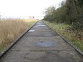
 Aust-concrete-path.jpg 800 × 600 ; 89 kio
-
 AustSevernPowerLine.jpg 640 × 480 ; 89 kio
-

-
 Avon Cycleway Link sign, Redhill - geograph.org.uk - 4241051.jpg 800 × 710 ; 122 kio
-
 B4461 by Lye Brake - geograph.org.uk - 2945788.jpg 1 024 × 768 ; 432 kio
-
 B4461 heading east. - geograph.org.uk - 3457581.jpg 640 × 480 ; 53 kio
-
 B4461 heading towards Alveston - geograph.org.uk - 3457705.jpg 640 × 480 ; 50 kio
-
 B4461 near Red Hill - geograph.org.uk - 2964935.jpg 1 024 × 731 ; 130 kio
-
 B4461 towards Alveston - geograph.org.uk - 3457577.jpg 640 × 480 ; 68 kio
-
 B4461 towards Aust - geograph.org.uk - 3158182.jpg 1 200 × 676 ; 412 kio
-
 B4461 towards the Severn Bridge - geograph.org.uk - 3282433.jpg 1 200 × 676 ; 411 kio
-
 Banks of the Severn - geograph.org.uk - 1731269.jpg 4 000 × 3 000 ; 2,89 Mio
-
 Banks of the Severn - geograph.org.uk - 1734436.jpg 4 000 × 3 000 ; 2,79 Mio
-
 Barn and paddock by Rushen Lane - geograph.org.uk - 2174579.jpg 640 × 480 ; 522 kio
-
 Barn, New House Farm, Aust - geograph.org.uk - 4245635.jpg 800 × 460 ; 86 kio
-
 Barrier across a private road, Aust - geograph.org.uk - 4040406.jpg 800 × 536 ; 98 kio
-
 Beachley end of Severn Bridge - geograph.org.uk - 2214250.jpg 800 × 600 ; 94 kio
-
 Below the eastern pylon, Severn Bridge - geograph.org.uk - 3693808.jpg 640 × 430 ; 43 kio
-

-
 Between the floodbank and Whale Wharf - geograph.org.uk - 2172671.jpg 640 × 427 ; 271 kio
-
 Beware of slow turning lorries near Redhill - geograph.org.uk - 4241076.jpg 800 × 633 ; 137 kio
-
 Beyond a barrier at the end of a lane from Aust - geograph.org.uk - 3716001.jpg 800 × 612 ; 139 kio
-
 Bicycle made for two near Aust - geograph.org.uk - 4241086.jpg 800 × 550 ; 117 kio
-
 Bikes Take Care electronic display, Aust - geograph.org.uk - 5275875.jpg 800 × 557 ; 111 kio
-

-
 Boar's Head Aust viewed from the east - geograph.org.uk - 3707180.jpg 800 × 662 ; 132 kio
-
 Boar's Head Aust viewed from the west - geograph.org.uk - 3707235.jpg 800 × 538 ; 103 kio
-
 Boars Head name sign, Aust - geograph.org.uk - 3707221.jpg 522 × 640 ; 107 kio
-
 Bond Lane - geograph.org.uk - 2151371.jpg 640 × 480 ; 565 kio
-
 Brightside, Aust (geograph 4234695).jpg 800 × 439 ; 80 kio
-
 Broadrush Brake creates an avenue of trees - geograph.org.uk - 3989782.jpg 1 024 × 768 ; 339 kio
-
 Buildings at Whale Wharf - geograph.org.uk - 2172654.jpg 640 × 426 ; 357 kio
-
 Bus stop at M48 motorway junction 1, Aust - geograph.org.uk - 3704876.jpg 800 × 662 ; 130 kio
-
 By the River Severn near Old Passage - geograph.org.uk - 3055513.jpg 2 592 × 1 944 ; 1,99 Mio
-
 Cake Pill - geograph.org.uk - 3457554.jpg 640 × 480 ; 44 kio
-
 Cake Pill - geograph.org.uk - 4268445.jpg 800 × 680 ; 166 kio
-
 Cake Pill Gout - geograph.org.uk - 4268544.jpg 800 × 659 ; 183 kio
-
 Cake Pill Gout - geograph.org.uk - 572513.jpg 640 × 480 ; 88 kio
-
 Cake Pill Gout - geograph.org.uk - 572522.jpg 480 × 640 ; 92 kio
-
 Cattle at the base of Aust Cliff - geograph.org.uk - 6052593.jpg 800 × 526 ; 95 kio
-
 Centre of the village, Aust - geograph.org.uk - 3754702.jpg 800 × 630 ; 93 kio
-

-
 Church of St John, Aust - geograph.org.uk - 4868133.jpg 3 776 × 2 520 ; 4,12 Mio
-
 Civilization^ - geograph.org.uk - 2175024.jpg 640 × 480 ; 537 kio
-

-
 Construction of the Severn Bridge (geograph 6776023).jpg 1 199 × 1 799 ; 259 kio
-
 Cophills Lane - geograph.org.uk - 2175039.jpg 512 × 640 ; 528 kio
-

-
 Coronation Lamp, Aust - geograph.org.uk - 3707328.jpg 800 × 753 ; 218 kio
-
 Cote Lodge - geograph.org.uk - 3282426.jpg 1 200 × 676 ; 408 kio
-
 Cote Lodge near Aust - geograph.org.uk - 4241105.jpg 800 × 539 ; 127 kio
-
 Cottage on Stock Hill - geograph.org.uk - 2827910.jpg 1 024 × 626 ; 82 kio
-
 Crop field off the B4461 - geograph.org.uk - 3457703.jpg 640 × 480 ; 77 kio
-
 Cropped field behind the Severn floodbank - geograph.org.uk - 2172071.jpg 640 × 427 ; 304 kio
-
 Crossing the Severn Road Bridge - geograph.org.uk - 5174464.jpg 1 600 × 1 200 ; 232 kio
-
 Cycle path across the Severn Bridge - geograph.org.uk - 2496950.jpg 2 816 × 2 112 ; 1,39 Mio
-

-
 Cycle route signs, Aust - geograph.org.uk - 4251470.jpg 800 × 719 ; 130 kio
-
 Cycle route towards the Old Severn Bridge, Aust - geograph.org.uk - 4251511.jpg 800 × 627 ; 127 kio
-
 Cycle signs and road signs neat Aust - geograph.org.uk - 6028148.jpg 1 024 × 768 ; 509 kio
-
 Cycle track warning sign, Aust - geograph.org.uk - 2953677.jpg 640 × 537 ; 89 kio
-
 Cyclepath on the Severn Bridge - geograph.org.uk - 3939083.jpg 4 320 × 3 240 ; 3,59 Mio
-
 Cycleway and footpath along the M48 motorway - geograph.org.uk - 6052649.jpg 800 × 565 ; 135 kio
-
 Cycleway and footpath on the Severn Bridge - geograph.org.uk - 6051746.jpg 800 × 570 ; 95 kio
-
 Cycleway and footpath on the Severn Bridge - geograph.org.uk - 6051760.jpg 637 × 800 ; 87 kio
-
 Cycleway and footpath on the Severn Bridge - geograph.org.uk - 6051856.jpg 771 × 800 ; 108 kio
-
 Cycling from Aust towards Wales - geograph.org.uk - 4597075.jpg 800 × 643 ; 129 kio
-
 Cycling towards Wales from Aust - geograph.org.uk - 2953884.jpg 640 × 483 ; 85 kio
-

-
 Descent towards Aust - geograph.org.uk - 5275914.jpg 800 × 630 ; 100 kio
-

-
 Distant pylon, Aust - geograph.org.uk - 4245627.jpg 800 × 600 ; 73 kio
-
 Distant view of the Second Severn Crossing - geograph.org.uk - 4251669.jpg 800 × 452 ; 87 kio
-
 Disused petrol pumps in Aust village - geograph.org.uk - 1742999.jpg 4 288 × 2 848 ; 3,05 Mio
-
 Double gates at a field entrance, Redhill - geograph.org.uk - 4241029.jpg 800 × 600 ; 131 kio
-
 Dry drainage channel, Aust - geograph.org.uk - 3716099.jpg 800 × 600 ; 202 kio
-
 Dual carriageway section of the B4461, Aust - geograph.org.uk - 4242414.jpg 800 × 548 ; 76 kio
-
 East side of Cake Pill Outfall - geograph.org.uk - 4268470.jpg 800 × 478 ; 90 kio
-
 East side of St John's Church, Aust - geograph.org.uk - 3715896.jpg 800 × 800 ; 106 kio
-
 Eastern pylon at Aust - geograph.org.uk - 6051847.jpg 800 × 441 ; 33 kio
-

-
 Electricity pylon near a road junction, Redhill - geograph.org.uk - 4241047.jpg 799 × 800 ; 119 kio
-
 End of a motorway slip road, Aust - geograph.org.uk - 2953702.jpg 640 × 480 ; 76 kio
-

-
 Enlarged paddock - geograph.org.uk - 2174377.jpg 640 × 427 ; 377 kio
-
 Entering the Village of Aust - geograph.org.uk - 4834197.jpg 1 600 × 1 067 ; 794 kio
-

-
 Entrance gates to Whale Wharf business park - geograph.org.uk - 2748579.jpg 640 × 428 ; 58 kio
-

-
 Entrance to Brightside site, Aust - geograph.org.uk - 2855559.jpg 640 × 480 ; 87 kio
-
 Entrance to Lodge Farm - geograph.org.uk - 2176451.jpg 640 × 480 ; 373 kio
-
 Entrance to Manor Farm Offices, Aust - geograph.org.uk - 4242449.jpg 800 × 600 ; 124 kio
-
 Entrance to New House Farm caravan site, Aust - geograph.org.uk - 4245646.jpg 800 × 462 ; 106 kio
-
 Entrance to Whale Wharf Industrial Estate - geograph.org.uk - 2172557.jpg 640 × 427 ; 342 kio
-
 ESE along the B4461, Aust - geograph.org.uk - 4251497.jpg 800 × 676 ; 108 kio
-
 Esperanza, Aust - geograph.org.uk - 4605627.jpg 2 592 × 1 944 ; 1,41 Mio
-
 Exit slip road at M48 motorway junction 1, Aust - geograph.org.uk - 3704793.jpg 800 × 600 ; 126 kio
-
 Farm building off the B4461 - geograph.org.uk - 3457702.jpg 640 × 480 ; 72 kio
-
 Farm buildings in Aust - geograph.org.uk - 3715967.jpg 800 × 566 ; 103 kio
-
 Farm track ^ footpath from Lynch Farm to Cote Farm - geograph.org.uk - 3495371.jpg 3 648 × 2 736 ; 3,46 Mio
-
 Farmland near Elberton - geograph.org.uk - 3457585.jpg 640 × 480 ; 55 kio
-
 Farmland near Ingst - geograph.org.uk - 5150548.jpg 2 487 × 1 865 ; 1 Mio
-
 Farmland off the A403 - geograph.org.uk - 3457551.jpg 640 × 480 ; 69 kio
-
 Fence over the floodbank - geograph.org.uk - 2172647.jpg 640 × 426 ; 350 kio
-
 Ferry-Bridge - geograph.org.uk - 6203054.jpg 1 024 × 344 ; 42 kio
-
 Field by Rushen Lane - geograph.org.uk - 6252522.jpg 4 032 × 3 024 ; 3,11 Mio
-
 Field entrance off the A403 - geograph.org.uk - 3457574.jpg 640 × 480 ; 96 kio
-
 Field entrance off the B4461 - geograph.org.uk - 3457576.jpg 640 × 480 ; 72 kio
-
 Field near Kyneton Park Lodge - geograph.org.uk - 2151368.jpg 640 × 426 ; 347 kio
-

-
 Fields behind the Severn floodbank - geograph.org.uk - 2172044.jpg 640 × 426 ; 348 kio
-
 Fields in Littleton-upon-Severn - geograph.org.uk - 2748051.jpg 2 592 × 1 944 ; 1,39 Mio
-
 Fields in the angle of Bond Lane - geograph.org.uk - 2151374.jpg 640 × 426 ; 310 kio
-
 Fields near Aust - geograph.org.uk - 2496969.jpg 2 816 × 2 112 ; 1,64 Mio
-
 Fields west of Aust - geograph.org.uk - 3056135.jpg 2 592 × 1 944 ; 2 Mio
-
-
 Flood plain grassland - geograph.org.uk - 2694162.jpg 1 024 × 769 ; 191 kio
-

-
 Footbridge over the M48 at Aust - geograph.org.uk - 6062218.jpg 2 592 × 1 944 ; 1,32 Mio
-

-

-
 Footpath - geograph.org.uk - 190606.jpg 480 × 640 ; 144 kio
-
 Footpath and cycle path across the Severn Bridge - geograph.org.uk - 4605493.jpg 2 592 × 1 944 ; 1,17 Mio
-

-
 Footpath crossing a country lane - geograph.org.uk - 2908915.jpg 1 024 × 768 ; 229 kio
-
 Footpath under the M4 - geograph.org.uk - 3939051.jpg 4 320 × 3 240 ; 2,93 Mio
-
 Forest of Dean , Beachley Barracks - geograph.org.uk - 4623036.jpg 4 288 × 2 848 ; 5,16 Mio
-
 Forest of Dean , River Severn - geograph.org.uk - 4623268.jpg 4 288 × 2 848 ; 5,83 Mio
-
 Forest of Dean , River Severn Riverbank - geograph.org.uk - 4623049.jpg 4 258 × 2 828 ; 4,62 Mio
-
 Forest of Dean , Slimeroad Pill - geograph.org.uk - 4623054.jpg 4 288 × 2 848 ; 4,31 Mio
-

-
 Former Severn ferry terminal at Aust - geograph.org.uk - 2496962.jpg 3 800 × 1 682 ; 1,74 Mio
-

-
 Fuel tanker in Severn View Services, Aust - geograph.org.uk - 4764635.jpg 800 × 575 ; 98 kio
-


.jpg)


_-_geograph.org.uk_-_542307.jpg)
_-_geograph.org.uk_-_542341.jpg)


.jpg)


.jpg)


