Category:Bageshwar district
Zur Navigation springen
Zur Suche springen
Distrikt in Indien .svg) | |||||
| Medium hochladen | |||||
| Ist ein(e) | |||||
|---|---|---|---|---|---|
| Ort |
| ||||
| Hauptstadt | |||||
| Einwohnerzahl |
| ||||
| Fläche |
| ||||
| offizielle Website | |||||
 | |||||
Unterkategorien
Es werden 5 von insgesamt 5 Unterkategorien in dieser Kategorie angezeigt:
In Klammern die Anzahl der enthaltenen Kategorien (K), Seiten (S), Dateien (D)
B
- Baijnath Lake (7 D)
- Binsar Wildlife Sanctuary (17 D)
P
- Pindari glacier (9 D)
Medien in der Kategorie „Bageshwar district“
Folgende 24 Dateien sind in dieser Kategorie, von 24 insgesamt.
-
 Aqua (54622704).jpeg 2.048 × 1.365; 817 KB
-
 Bageshwar-Kanda road 01.jpg 2.975 × 2.231; 2,63 MB
-
 Bageshwar-Kanda road 02.jpg 3.293 × 2.470; 3,54 MB
-
 Bageshwar-Kanda road 03.jpg 3.179 × 2.384; 1,39 MB
-
 Fog rising above pine woods near Bageshwar.jpg 4.200 × 2.362; 2,96 MB
-
 Gomati River 01.jpg 4.160 × 3.120; 4,99 MB
-
 Gomati river 02.jpg 4.160 × 3.120; 4,67 MB
-
 Gomati river 03.jpg 3.720 × 2.539; 2,9 MB
-
 Gomati river 04.jpg 4.160 × 3.120; 4,34 MB
-
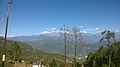 Himalayan view from NH309A.jpg 2.592 × 1.456; 1,16 MB
-
 Kalna Bend, Bageshwar.jpg 4.160 × 3.120; 3,77 MB
-
 Karmi Valley in Bageshwar District.jpg 5.961 × 3.615; 6,05 MB
-
 Katyur Valley.jpg 4.160 × 3.120; 2,82 MB
-
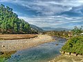
 Saryu river - panoramio.jpg 4.288 × 2.848; 1,47 MB
-
 Tea and pine trees - panoramio.jpg 2.816 × 2.112; 2,29 MB
-
 Tea plantation below Kausani 11-2009 - panoramio.jpg 2.816 × 2.112; 4,05 MB
-
 Tea plantation below Kausani, 11-2009 - panoramio.jpg 2.816 × 2.112; 3,18 MB
-
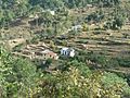
 Terraced fields below Kausani 11-2009 - panoramio.jpg 2.560 × 1.920; 2,3 MB
-
 Terraced fields below Kausani, 11-2009 - panoramio.jpg 3.072 × 2.304; 3,44 MB
-

-
 Towards Dhakuri.jpg 1.440 × 696; 240 KB
-
 Unidentified lizard, Gogina, Uttarakhand, India.jpg 4.000 × 2.265; 5,23 MB
-
 Vegetation destroyed after 2016 Uttarakhand Forest Fires.jpg 4.128 × 3.096; 8,98 MB
-
 Verditer flycatcher perched on a guava tree.jpg 2.367 × 3.313; 1,69 MB
.jpeg)


