Category:Bagillt
Vai alla navigazione
Vai alla ricerca
comunità del Galles   | |||||
| Carica un file multimediale | |||||
| Istanza di | |||||
|---|---|---|---|---|---|
| Luogo | Flintshire, Galles | ||||
| Popolazione |
| ||||
| Superficie |
| ||||
 | |||||
Sottocategorie
Questa categoria contiene le 2 sottocategorie indicate di seguito, su un totale di 2.
B
- Bagillt railway station (2 F)
S
- St Mary's Church, Bagillt (12 F)
File nella categoria "Bagillt"
Questa categoria contiene 200 file, indicati di seguito, su un totale di 273.
(pagina precedente) (pagina successiva)-
 'The Marsh', between Bagillt and Flint - geograph.org.uk - 5591017.jpg 1 024 × 768; 149 KB
-
 'Wright Garden Buildings Ltd' - geograph.org.uk - 5590250.jpg 1 024 × 768; 149 KB
-
 158825 approaching Bagillt - May 2017 - geograph.org.uk - 5380080.jpg 1 250 × 866; 1,17 MB
-
 2010 Wales Flintshire Community Bagillt map.svg 512 × 568; 494 KB
-
 2024 Wales Flintshire Community Bagillt map.svg 512 × 568; 394 KB
-
 57303 at Bagillt.jpg 2 400 × 1 600; 532 KB
-
 A pile of aggregate - geograph.org.uk - 4498331.jpg 640 × 426; 54 KB
-
 A roads - geograph.org.uk - 2275060.jpg 1 567 × 2 000; 528 KB
-
 A548 at Bagillt - geograph.org.uk - 3392866.jpg 640 × 480; 63 KB
-
 A548 at Bagillt station - geograph.org.uk - 2989661.jpg 1 600 × 1 200; 476 KB
-
 A548 at Whelston - geograph.org.uk - 3392872.jpg 640 × 480; 46 KB
-
 A548 Bagillt by-pass - geograph.org.uk - 3392870.jpg 640 × 481; 46 KB
-
 A548 bypassing Whelston - geograph.org.uk - 5319638.jpg 640 × 480; 65 KB
-
 A55 North Wales Expressway - geograph.org.uk - 99078.jpg 640 × 480; 53 KB
-
 All Gas and Gaiters - geograph.org.uk - 41398.jpg 640 × 480; 153 KB
-

-

-
 Bagillt across a lake - geograph.org.uk - 4498328.jpg 640 × 426; 51 KB
-
 Bagillt Arms Hotel - geograph.org.uk - 5318914.jpg 640 × 480; 71 KB
-
 Bagillt CH6, UK - panoramio - IIya Kuzhekin (1).jpg 4 000 × 3 000; 4,42 MB
-
 Bagillt CH6, UK - panoramio - IIya Kuzhekin.jpg 4 000 × 3 000; 4,54 MB
-
 Bagillt CH6, UK - panoramio.jpg 4 000 × 3 000; 2,14 MB
-
 Bagillt Community Centre, High Street, Bagillt - geograph.org.uk - 5590185.jpg 1 024 × 768; 171 KB
-
 Bagillt dock - geograph.org.uk - 5318904.jpg 640 × 480; 62 KB
-
 Bagillt harbour NLW3362253.jpg 602 × 452; 45 KB
-
 Bagillt level crossing - geograph.org.uk - 5590943.jpg 1 024 × 768; 186 KB
-
 Bagillt United Reformed Church - geograph.org.uk - 101376.jpg 640 × 480; 68 KB
-
 Bagillt up stopping train geograph-2723640-by-Ben-Brooksbank.jpg 2 343 × 1 448; 856 KB
-
 Bagillt War Memorial - geograph.org.uk - 5318929.jpg 462 × 640; 58 KB
-
 Bagillt, UK - panoramio - IIya Kuzhekin.jpg 4 000 × 2 250; 2,17 MB
-
 Bagillt, UK - panoramio.jpg 4 000 × 2 667; 3,17 MB
-
 Bagillt.jpg 1 812 × 1 208; 1,05 MB
-
 Barn at Fferm, Bryntirion Road - geograph.org.uk - 6147689.jpg 4 000 × 3 000; 2,4 MB
-
 Bettisfield - Gateway to the Dee - geograph.org.uk - 4908546.jpg 3 184 × 2 123; 2,5 MB
-
 Bettisfield Dragon Beacon on Bagillt Cob - geograph.org.uk - 4755353.jpg 1 024 × 768; 158 KB
-
 Between Bagillt and Greenfield - geograph.org.uk - 2804605.jpg 640 × 480; 68 KB
-
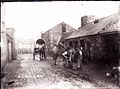 Blacksmiths at Bagillt, 1908.JPG 624 × 462; 221 KB
-
 Boats at Dee Banks Gutter - geograph.org.uk - 6126617.jpg 800 × 598; 112 KB
-
 Boats in Dee Banks Gutter - geograph.org.uk - 6195317.jpg 800 × 599; 126 KB
-

-
 Boot End - geograph.org.uk - 2275085.jpg 4 000 × 3 000; 5,87 MB
-
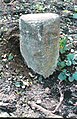
 Boundary stone near Panton Cop, Bagillt - geograph.org.uk - 5593812.jpg 768 × 1 024; 285 KB
-
 Bryntirion Road, Bedol - geograph.org.uk - 3842340.jpg 1 024 × 636; 116 KB
-
 Buoy on the Dee estuary - geograph.org.uk - 6126672.jpg 800 × 774; 86 KB
-
 Car Repairs - geograph.org.uk - 2275152.jpg 4 000 × 3 000; 5,86 MB
-
 Coastal erosion - geograph.org.uk - 1870603.jpg 2 048 × 1 536; 1,33 MB
-
 Coastal erosion - geograph.org.uk - 3192657.jpg 1 600 × 1 200; 332 KB
-
 Coastal Path and protective stones - geograph.org.uk - 3192660.jpg 1 600 × 1 200; 388 KB
-
 Cocaoa House plaque - geograph.org.uk - 5318923.jpg 640 × 480; 94 KB
-
 Cocoa House, Bagillt - geograph.org.uk - 5318920.jpg 640 × 480; 59 KB
-
 Coleshill Road at Bagillt - geograph.org.uk - 6163514.jpg 800 × 600; 164 KB
-

-

-
 Curlew and Grey Heron in the Dee estuary - geograph.org.uk - 5593694.jpg 1 024 × 769; 142 KB
-
 Cychod ym Magillt - Boats at Bagillt - geograph.org.uk - 5989886.jpg 640 × 467; 99 KB
-
 Dee Banks Gutter along the Dee Estuary - geograph.org.uk - 6163631.jpg 800 × 531; 113 KB
-
 Dee Banks Gutter along the Dee Estuary - geograph.org.uk - 6195315.jpg 800 × 600; 140 KB
-
 Dee Banks Gutter, Bagillt - geograph.org.uk - 2804556.jpg 640 × 480; 82 KB
-
 Dee Banks Gutter, Bagillt - geograph.org.uk - 2804558.jpg 640 × 480; 69 KB
-
 Dee Estuary near Bagillt - geograph.org.uk - 6163931.jpg 800 × 618; 122 KB
-
 Derelict Arms - geograph.org.uk - 2275119.jpg 4 000 × 3 000; 4,95 MB
-

-
 Divert Left - geograph.org.uk - 2275247.jpg 4 000 × 3 000; 4,91 MB
-
 Down North Wales express near Flint, 1964 - geograph.org.uk - 4251517.jpg 2 439 × 1 438; 1,4 MB
-
 Drain behind the sea wall - geograph.org.uk - 2986920.jpg 1 600 × 1 200; 581 KB
-
 Drain from the old Bagillt reservoir - geograph.org.uk - 2989734.jpg 1 600 × 1 200; 428 KB
-
 Drainage gully in the saltmarsh - geograph.org.uk - 2805469.jpg 640 × 480; 78 KB
-
 Drainage water at Dee Bank Quay - geograph.org.uk - 4904358.jpg 3 184 × 2 123; 2,37 MB
-

-
 Electric Farm - geograph.org.uk - 2275334.jpg 4 000 × 3 000; 5,78 MB
-

-
 Evan Hughes' house, Bagillt NLW3363181.jpg 584 × 418; 61 KB
-
 Exit Route - geograph.org.uk - 2275223.jpg 3 000 × 4 000; 4,98 MB
-
 Farm near Bagillt, Flintshire - geograph.org.uk - 198039.jpg 640 × 480; 73 KB
-
 Ffagl Bagillt - Bagillt Beacon - geograph.org.uk - 5989890.jpg 640 × 467; 40 KB
-
 Ffordd Bryn Tirion, Bagillt - geograph.org.uk - 99035.jpg 640 × 480; 78 KB
-
 Field, Walwen - geograph.org.uk - 4498332.jpg 640 × 414; 47 KB
-
 Fishing boats on the Dee Banks Gutter - geograph.org.uk - 4905067.jpg 3 184 × 2 123; 1,74 MB
-
 Fishing Boats on the Dee Banks Gutter - geograph.org.uk - 4905072.jpg 5 000 × 3 333; 4,43 MB
-
 Fishing Boats on the Dee Banks Gutter - geograph.org.uk - 4918196.jpg 5 184 × 3 456; 3,43 MB
-
 Flat farmland - geograph.org.uk - 4556879.jpg 640 × 426; 35 KB
-
 Flat grazing land - geograph.org.uk - 4556890.jpg 640 × 426; 32 KB
-
 Footbridge over the North Wales Coast Line - geograph.org.uk - 4910325.jpg 3 184 × 2 123; 1,84 MB
-
 Footbridge over the North Wales railway line - geograph.org.uk - 5590266.jpg 1 024 × 768; 223 KB
-

-
 Footpath near the civic amenity site - geograph.org.uk - 1870622.jpg 640 × 480; 79 KB
-
 Footpath, former tramway, and boundary stone - geograph.org.uk - 5593825.jpg 1 024 × 768; 276 KB
-

-
 Frosty morning - geograph.org.uk - 1310888.jpg 640 × 428; 93 KB
-
 Gadlys Lane - geograph.org.uk - 2275129.jpg 4 000 × 3 000; 4,81 MB
-
 Gadlys Lane - geograph.org.uk - 2275276.jpg 4 000 × 3 000; 4,97 MB
-
 Gadlys Lane - geograph.org.uk - 2275290.jpg 4 000 × 3 000; 5,86 MB
-

-
 Grassland behind the sea wall - geograph.org.uk - 5318662.jpg 640 × 480; 67 KB
-
 Grassland on Panton Cop - geograph.org.uk - 2988218.jpg 1 600 × 1 200; 376 KB
-
 Grazing beside the sea wall - geograph.org.uk - 2989624.jpg 1 600 × 1 200; 342 KB
-
 Grazings known as The Marsh - geograph.org.uk - 2988566.jpg 1 600 × 1 200; 287 KB
-
 Grazings on Panton Cop - geograph.org.uk - 2988233.jpg 1 600 × 1 200; 348 KB
-
 Green Bend - geograph.org.uk - 2275202.jpg 4 000 × 3 000; 5,95 MB
-

-
 Gwter yr Orsaf - geograph.org.uk - 2989765.jpg 1 600 × 1 200; 326 KB
-
 High and dry - geograph.org.uk - 5318868.jpg 640 × 480; 68 KB
-
 Holyhead to Chester train - geograph.org.uk - 2989806.jpg 1 600 × 1 200; 407 KB
-
 Horses near Milwr Road - geograph.org.uk - 104449.jpg 640 × 480; 85 KB
-
 Industrial Estate Road - geograph.org.uk - 4493402.jpg 640 × 426; 60 KB
-
 Industrial unit - geograph.org.uk - 4493407.jpg 640 × 426; 66 KB
-
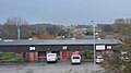 Industrial units - geograph.org.uk - 4493408.jpg 640 × 357; 39 KB
-
 Industrial units adjacent to the A548 - geograph.org.uk - 103871.jpg 640 × 480; 54 KB
-
 Kingdom Hall, Bagillt - geograph.org.uk - 5318950.jpg 640 × 480; 47 KB
-
 Kissing gate - geograph.org.uk - 5318793.jpg 640 × 480; 118 KB
-
 Kissing gate along the Wales Coast Path - geograph.org.uk - 6195325.jpg 800 × 572; 152 KB
-
 Kissing gate alongside the Wales Coast Path - geograph.org.uk - 5591000.jpg 1 024 × 768; 158 KB
-
 Lake, Bagillt - geograph.org.uk - 4498322.jpg 640 × 295; 34 KB
-
 Land behind the seawall - geograph.org.uk - 4556886.jpg 640 × 367; 34 KB
-
 Llwybr Arfordir Cymru - geograph.org.uk - 2988205.jpg 1 600 × 1 200; 472 KB
-
 Llwybr Arfordir Cymru - geograph.org.uk - 2988529.jpg 1 600 × 1 200; 444 KB
-
 Llwybr Arfordir Cymru - geograph.org.uk - 2989642.jpg 1 600 × 1 200; 451 KB
-
 Llwybr Arfordir Cymru - geograph.org.uk - 3192547.jpg 1 600 × 1 200; 421 KB
-
-
 Looking east from the sea wall - geograph.org.uk - 2988250.jpg 1 600 × 1 200; 586 KB
-

-
 Low tide on the Dee estuary - geograph.org.uk - 709252.jpg 640 × 480; 69 KB
-
 Main drain discharge - geograph.org.uk - 2986875.jpg 1 600 × 1 200; 307 KB
-
 Memorial at Dee Banks Gutter - geograph.org.uk - 3192818.jpg 1 600 × 1 200; 408 KB
-

-
 Mouth of Dee Banks Gutter, Bagillt - geograph.org.uk - 3192681.jpg 1 600 × 1 200; 340 KB
-
 Muddy field entrance - geograph.org.uk - 4556876.jpg 640 × 426; 41 KB
-
 Muddy shoreline along the Dee Estuary - geograph.org.uk - 6163929.jpg 800 × 600; 123 KB
-
 Narrow strip of salting - geograph.org.uk - 2988642.jpg 1 600 × 1 200; 198 KB
-
 New bridge - geograph.org.uk - 1870639.jpg 2 048 × 1 536; 1,38 MB
-
 New Brighton Road - geograph.org.uk - 2275078.jpg 4 000 × 3 000; 4,9 MB
-
 New clapper valve on Milwr Tunnel sluice - geograph.org.uk - 3192965.jpg 1 600 × 1 200; 471 KB
-
 New gates on the Coastal Path - geograph.org.uk - 2804576.jpg 640 × 480; 111 KB
-
 Newly planted bank - geograph.org.uk - 3192576.jpg 1 600 × 1 200; 384 KB
-
-
 On the path towards Coed Llwybr-y-bi, Holywell - geograph.org.uk - 4755345.jpg 1 024 × 768; 135 KB
-
 Outflow from Bagillt Reservoir at low tide - geograph.org.uk - 2331831.jpg 4 672 × 3 104; 5,97 MB
-
 Overgrown hedgerow on The Marsh - geograph.org.uk - 2988601.jpg 1 600 × 1 200; 501 KB
-
 Panton Cop - geograph.org.uk - 4556891.jpg 640 × 426; 32 KB
-
 Panton Cop - geograph.org.uk - 4556892.jpg 640 × 426; 33 KB
-
 Path along the Dee Estuary - geograph.org.uk - 6163667.jpg 800 × 600; 142 KB
-

-
 Path towards Dee Banks Gutter - geograph.org.uk - 6163683.jpg 800 × 600; 148 KB
-
 Pen y Maes at Greenfield - geograph.org.uk - 4902433.jpg 3 184 × 2 123; 3,45 MB
-
 Petrol station on the A548 - geograph.org.uk - 5318994.jpg 640 × 480; 35 KB
-
 Protective fence - geograph.org.uk - 2986940.jpg 1 600 × 1 200; 395 KB
-
 Railway at Bagillt station - geograph.org.uk - 2989694.jpg 1 600 × 1 200; 612 KB
-
 Railway towards Holyhead - geograph.org.uk - 2989711.jpg 1 600 × 1 200; 467 KB
-
 Receding shoreline - geograph.org.uk - 1870589.jpg 2 048 × 1 536; 1,15 MB
-

-
 Red skies above The Marsh - geograph.org.uk - 4556874.jpg 640 × 426; 37 KB
-
 Red skies near Bagillt - geograph.org.uk - 4556882.jpg 640 × 426; 37 KB
-
 Remains of Bettisfield Colliery Buildings, Bagillt - geograph.org.uk - 4907253.jpg 3 184 × 2 123; 1,66 MB
-
 Remains of Bettisfield Colliery Buildings, Bagillt - geograph.org.uk - 4908296.jpg 3 184 × 2 123; 1,66 MB
-
 Revd Benjamin Jones, Bagillt NLW3362694.jpg 448 × 597; 42 KB
-
 River Dee Co. boundary stone dated 1787 - geograph.org.uk - 5593674.jpg 767 × 1 024; 265 KB
-
 River Dee Company boundary stone dated 1787 - geograph.org.uk - 5593322.jpg 1 024 × 768; 527 KB
-
 Road to Bettisfield Colliery - geograph.org.uk - 2804546.jpg 640 × 480; 59 KB
-

-
 Salt marsh alongside the River Dee - geograph.org.uk - 5593317.jpg 1 024 × 768; 333 KB
-
 Saltings at Bagillt - geograph.org.uk - 2988702.jpg 1 600 × 1 200; 326 KB
-

-
 Saltmarshes by the Dee near Bagillt - geograph.org.uk - 2804561.jpg 640 × 480; 59 KB
-

-

-
 Self storage containers in Bagillt station yard - geograph.org.uk - 2989717.jpg 1 600 × 1 200; 456 KB
-
 Shoreline along the Dee Estuary - geograph.org.uk - 6163700.jpg 800 × 551; 118 KB
-
 Shoreline along the Dee Estuary - geograph.org.uk - 6195551.jpg 800 × 486; 84 KB
-

-

-
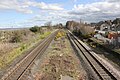 Site of Bagillt Railway Station - geograph.org.uk - 4910339.jpg 3 184 × 2 123; 2,26 MB
-
 Site of Bagillt Railway Station - geograph.org.uk - 4910577.jpg 3 184 × 2 123; 2,41 MB
-
 Site of derelict sewage works - geograph.org.uk - 2989777.jpg 1 600 × 1 200; 580 KB
-
 Site of the old Dee Bank Quay - geograph.org.uk - 4904411.jpg 3 184 × 2 123; 1,81 MB
-
 Slow Bungalows - geograph.org.uk - 2275099.jpg 4 000 × 3 000; 5,06 MB
-
 St Mary Church, Bagillt, Flintshire - geograph.org.uk - 5081554.jpg 2 304 × 1 728; 1 005 KB
-
 St Mary's Church in Bagillt - geograph.org.uk - 6163524.jpg 800 × 729; 187 KB
-
 St. Peter's Church - geograph.org.uk - 2275047.jpg 3 378 × 2 661; 5,33 MB
-
 St. Peter's Church - geograph.org.uk - 2275072.jpg 3 000 × 4 000; 5,83 MB
-

-
 Station Gutter at Bagillt - geograph.org.uk - 6163762.jpg 800 × 598; 137 KB
-
 Station Gutter at Bagillt - geograph.org.uk - 6163773.jpg 800 × 600; 139 KB
-
 Steam rises from the compost - geograph.org.uk - 2986892.jpg 1 600 × 1 200; 419 KB
-
 Steep Edge - geograph.org.uk - 2275311.jpg 4 000 × 3 000; 5,79 MB
-
 Step up - geograph.org.uk - 2275233.jpg 3 000 × 4 000; 5,88 MB
-

-
 Stream entering the Dee Estuary - geograph.org.uk - 4901158.jpg 3 184 × 2 123; 2,08 MB
-
 Stream flowing into the Dee Estuary - geograph.org.uk - 6196132.jpg 800 × 558; 141 KB
-
 Subway under the North Wales railway line - geograph.org.uk - 5590957.jpg 1 024 × 768; 320 KB
-
 Sunday Services - geograph.org.uk - 2275076.jpg 3 000 × 4 000; 5,06 MB
-

-
 The All Wales Coastal Path - geograph.org.uk - 2805462.jpg 480 × 640; 68 KB
-
 The Bagillt Beacon on Bagillt Cob - geograph.org.uk - 4905512.jpg 3 184 × 2 123; 1,54 MB
-
 The Bagillt Beacon on Bagillt Cob - geograph.org.uk - 4905537.jpg 3 184 × 2 123; 1,77 MB
-
 The Bagillt Beacon on Bagillt Cob - geograph.org.uk - 4905541.jpg 3 184 × 2 123; 1,72 MB
-
 The Bagillt Gutter - geograph.org.uk - 4909805.jpg 3 184 × 2 123; 2,09 MB
-
 The Blossoms, Bagillt - geograph.org.uk - 99032.jpg 640 × 480; 78 KB
-
 The Dee Banks Gutter at Bagillt - geograph.org.uk - 4905040.jpg 3 184 × 2 123; 2,32 MB
-
 The Dee estuary - geograph.org.uk - 5318509.jpg 640 × 480; 63 KB
-


.jpg)


