Category:Barrowby
Vai alla navigazione
Vai alla ricerca
English: Barrowby is a large village lying just to the west of Grantham, in the South Kesteven district of Lincolnshire, England, separated from that town by the main A1 road. Barrowby lies just where the A52 road crosses the A1 road.

village and civil parish in Lincolnshire, England  | |||||
| Carica un file multimediale | |||||
| Istanza di | |||||
|---|---|---|---|---|---|
| Luogo | South Kesteven, Lincolnshire, Midlands Orientali, Inghilterra | ||||
 | |||||
Sottocategorie
Questa categoria contiene le 5 sottocategorie indicate di seguito, su un totale di 5.
File nella categoria "Barrowby"
Questa categoria contiene 200 file, indicati di seguito, su un totale di 219.
(pagina precedente) (pagina successiva)-
 A new village sign for Barrowby - geograph.org.uk - 877016.jpg 640 × 480; 165 KB
-
 A Restricted Byway - geograph.org.uk - 3921201.jpg 1 600 × 1 067; 637 KB
-
 A very large flat field - geograph.org.uk - 4320341.jpg 640 × 430; 35 KB
-
 A1 - approaching A52 junction - geograph.org.uk - 2644371.jpg 640 × 428; 78 KB
-
 A1 - unusual speed camera - geograph.org.uk - 2644378.jpg 640 × 428; 86 KB
-
 A1 between Barrowby and Great Gonerby - geograph.org.uk - 3450800.jpg 1 605 × 1 006; 946 KB
-
 A1 crossing bridge over railway - geograph.org.uk - 5132846.jpg 640 × 481; 49 KB
-
 A1 looking north - geograph.org.uk - 241196.jpg 640 × 480; 61 KB
-
 A1 near Barrowby - geograph.org.uk - 4216724.jpg 640 × 480; 234 KB
-
 A1 northbound - geograph.org.uk - 5501978.jpg 640 × 428; 102 KB
-
 A1 northbound - geograph.org.uk - 5501994.jpg 640 × 428; 106 KB
-
 A1 northbound - geograph.org.uk - 5502008.jpg 640 × 428; 98 KB
-
 A1 northbound - geograph.org.uk - 5502018.jpg 640 × 428; 97 KB
-
 A1 northbound - geograph.org.uk - 5502034.jpg 640 × 428; 95 KB
-
 A1 northbound - geograph.org.uk - 5502045.jpg 640 × 428; 94 KB
-
 A1 northbound - geograph.org.uk - 5787383.jpg 640 × 452; 47 KB
-
 A1 northbound - geograph.org.uk - 5787385.jpg 640 × 432; 37 KB
-
 A1 northbound - geograph.org.uk - 5787387.jpg 640 × 442; 37 KB
-
 A1 northbound - geograph.org.uk - 5787389.jpg 640 × 430; 46 KB
-
 A1 northbound near Barrowby - geograph.org.uk - 3575202.jpg 640 × 480; 52 KB
-

-
 A1 turn off for A52 - geograph.org.uk - 3454461.jpg 1 480 × 883; 713 KB
-
 A1, Great Gonerby - geograph.org.uk - 3192916.jpg 640 × 430; 37 KB
-
 A52 becomes a dual carriageway - geograph.org.uk - 3575198.jpg 640 × 480; 55 KB
-
 A52 eastbound near Sedgebook - geograph.org.uk - 3575075.jpg 640 × 480; 60 KB
-
 A52 heading towards Grantham - geograph.org.uk - 3575078.jpg 640 × 480; 62 KB
-
 A52 heading towards Grantham - geograph.org.uk - 3575200.jpg 640 × 480; 60 KB
-
 A52 North of Barrowby - geograph.org.uk - 4225420.jpg 640 × 480; 296 KB
-
 A52 overbridge, A1 - geograph.org.uk - 2513201.jpg 640 × 269; 29 KB
-
 All Saints C of E church - geograph.org.uk - 2817025.jpg 640 × 480; 87 KB
-
 Allington Junction - geograph.org.uk - 3921205.jpg 4 272 × 2 848; 5,48 MB
-
 Allington Junction - geograph.org.uk - 4320360.jpg 640 × 430; 55 KB
-
 Allington Junction Level Crossing - geograph.org.uk - 4238099.jpg 4 000 × 3 000; 2,11 MB
-
 Allington lane - geograph.org.uk - 2031614.jpg 640 × 427; 72 KB
-
 Allington Lane - geograph.org.uk - 6340513.jpg 1 024 × 768; 274 KB
-
 Allington Lane leading to Allington Junction - geograph.org.uk - 6019911.jpg 3 776 × 2 520; 3,91 MB
-

-
 Allington Lane level crossing - geograph.org.uk - 5280254.jpg 1 280 × 960; 317 KB
-
 Allington Lane, near Grantham - geograph.org.uk - 281390.jpg 640 × 427; 91 KB
-
 Allington signal box - geograph.org.uk - 5280257.jpg 1 280 × 960; 274 KB
-
 Allington West junction - geograph.org.uk - 5280255.jpg 1 280 × 960; 364 KB
-
 Approaching Barrowby - geograph.org.uk - 2741025.jpg 3 344 × 2 534; 2,68 MB
-
 Arable land at Coe Farm - geograph.org.uk - 2749179.jpg 3 648 × 2 736; 3,36 MB
-
 At the edge of Barrowby Thorns - geograph.org.uk - 4578366.jpg 640 × 480; 138 KB
-
 Barrowby C of E Primary School - geograph.org.uk - 2817021.jpg 640 × 480; 110 KB
-
 Barrowby Chapel.JPG 3 544 × 2 456; 3,65 MB
-

-
 Barrowby Church of England Primary School - geograph.org.uk - 6294917.jpg 1 024 × 768; 206 KB
-
 Barrowby Old Schoolhouse.JPG 3 652 × 2 228; 3,31 MB
-
 Barrowby Reading Room - geograph.org.uk - 3653724.jpg 640 × 481; 237 KB
-
 Barrowby Road (A52) - geograph.org.uk - 3575207.jpg 640 × 480; 64 KB
-
 Barrowby Village Sign - geograph.org.uk - 3653713.jpg 480 × 640; 283 KB
-
 Barrowby village sign,Rectory Lane - geograph.org.uk - 2817648.jpg 1 024 × 768; 168 KB
-

-
 Barrowby, The Drift - geograph.org.uk - 3653620.jpg 640 × 481; 276 KB
-
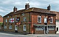
 Barrowby, The White Swan - geograph.org.uk - 3653703.jpg 640 × 481; 255 KB
-
 Barrowby, White Swan.JPG 3 544 × 2 244; 3,3 MB
-
 Barrowby, White's Directory of Lincolnshire 1872.jpg 1 234 × 1 373; 1 013 KB
-
 Barrowby4.jpg 360 × 480; 42 KB
-
 Base of a pylon and farmland - geograph.org.uk - 4320348.jpg 640 × 430; 51 KB
-
 Bench Mark and bolt - geograph.org.uk - 2817034.jpg 640 × 480; 97 KB
-

-
 Benchmark on post office - geograph.org.uk - 6175905.jpg 1 024 × 683; 215 KB
-
 Benchmark on ^29 High Road - geograph.org.uk - 6231157.jpg 612 × 1 024; 259 KB
-

-
 Bridge 52 of the Grantham Canal - geograph.org.uk - 2083147.jpg 640 × 480; 111 KB
-
 Bridge 63, Grantham Canal - geograph.org.uk - 6089021.jpg 1 024 × 768; 223 KB
-

-
 Bridge No 63 crossing the Grantham Canal - geograph.org.uk - 5585192.jpg 800 × 586; 176 KB
-
 Bridle Bridge No 63 - geograph.org.uk - 5253133.jpg 800 × 633; 182 KB
-
 Burial ground, Barrowby - geograph.org.uk - 6294743.jpg 1 024 × 768; 219 KB
-
 Butt Lane (1) - geograph.org.uk - 4296325.jpg 2 816 × 2 112; 2,18 MB
-
 Butt Lane (2) - geograph.org.uk - 4296363.jpg 2 816 × 2 112; 1,99 MB
-
 Canal Milemarker (geograph 6126179).jpg 427 × 640; 72 KB
-
 Casthorpe Bridge - geograph.org.uk - 3610573.jpg 640 × 477; 78 KB
-
 Casthorpe Road - geograph.org.uk - 4041103.jpg 640 × 480; 88 KB
-
 Casthorpe Road - geograph.org.uk - 4041110.jpg 640 × 480; 97 KB
-
 Casthorpe Road - geograph.org.uk - 4041112.jpg 640 × 480; 71 KB
-
 Casthorpe Road - geograph.org.uk - 4041118.jpg 640 × 480; 79 KB
-
 Casthorpe Road Bridge No 64 - geograph.org.uk - 5253175.jpg 800 × 545; 122 KB
-
 Casthorpe Road heading north - geograph.org.uk - 3610566.jpg 640 × 480; 71 KB
-
 Cereal field and Casthorpe Hills - geograph.org.uk - 6089784.jpg 1 024 × 768; 255 KB
-
 Church of All Saints, Barrowby - geograph.org.uk - 5245837.jpg 3 776 × 2 520; 4,11 MB
-
 Concrete culvert over Old Beck - geograph.org.uk - 5850475.jpg 1 600 × 1 067; 371 KB
-
 Cottage, Barrowby - geograph.org.uk - 4041120.jpg 640 × 480; 56 KB
-
 Cottages, Church Street, Barrowby (geograph 6294945).jpg 1 024 × 768; 215 KB
-
 Countryside and the Grantham Canal - geograph.org.uk - 4285838.jpg 2 816 × 2 112; 1,25 MB
-
 Countryside near Casthorpe - geograph.org.uk - 4269726.jpg 4 000 × 3 000; 3,87 MB
-
 Countryside near Casthorpe - geograph.org.uk - 4285821.jpg 2 816 × 2 112; 1,12 MB
-
 Crop field east of Sedgebrook - geograph.org.uk - 3575074.jpg 640 × 480; 81 KB
-
 Crop field, Boundary Farm - geograph.org.uk - 3575203.jpg 640 × 480; 54 KB
-
 Crop marks in a field in Casthorpe Hills - geograph.org.uk - 5846328.jpg 800 × 533; 103 KB
-
 Cropland near the Grantham Canal - geograph.org.uk - 2748641.jpg 3 418 × 2 485; 2,91 MB
-

-
 Double bend on Denton Lane - geograph.org.uk - 5246935.jpg 3 776 × 2 520; 4,05 MB
-
 Electricity line off Allington Lane - geograph.org.uk - 6340878.jpg 1 024 × 768; 140 KB
-
 Entering Barrowby - geograph.org.uk - 5246941.jpg 3 776 × 2 520; 3,93 MB
-
 Entrance to New Barn Farm - geograph.org.uk - 3905354.jpg 4 127 × 2 751; 6,51 MB
-
 Farm track off Casthorpe Road - geograph.org.uk - 4041098.jpg 640 × 480; 88 KB
-
 Farmland by the A1 - geograph.org.uk - 2622442.jpg 640 × 267; 24 KB
-
 Farmland near Allington Junction - geograph.org.uk - 4320345.jpg 640 × 430; 43 KB
-
 Farmland near Casthorpe House Farm - geograph.org.uk - 2748609.jpg 3 648 × 2 736; 2,82 MB
-
 Farmland near the Grantham Canal - geograph.org.uk - 3610571.jpg 640 × 480; 61 KB
-
 Farmland north of Harlaxton, aerial 2018 - geograph.org.uk - 5846337.jpg 800 × 533; 103 KB
-
 Farmland off The Drift - geograph.org.uk - 3610691.jpg 640 × 480; 71 KB
-
 Farmland towards New Barn Farm - geograph.org.uk - 4041106.jpg 640 × 480; 70 KB
-
 Farmland west of Allington Junction - geograph.org.uk - 4320353.jpg 640 × 430; 35 KB
-
 Farmland, Knowles Farm - geograph.org.uk - 3575192.jpg 640 × 480; 66 KB
-
 Field edge at Casthorpe - geograph.org.uk - 6340883.jpg 1 024 × 768; 274 KB
-
 Field Entrance off Rectory Lane - geograph.org.uk - 4296381.jpg 2 816 × 2 112; 1,11 MB
-
 Footpath and track over Old Beck - geograph.org.uk - 3918174.jpg 4 272 × 2 848; 6,29 MB
-
 Footpath below Stubbock Hill - geograph.org.uk - 6019917.jpg 3 776 × 2 520; 3,04 MB
-
 Footpath by Barrowby Church - geograph.org.uk - 3870656.jpg 1 024 × 768; 259 KB
-
 Footpath down the north side of Stubbock Hill - geograph.org.uk - 6019926.jpg 3 776 × 2 520; 4,16 MB
-
 Footpath down to the Vale of Belvoir - geograph.org.uk - 5245853.jpg 3 776 × 2 520; 4,17 MB
-
 Footpath to Barrowby - geograph.org.uk - 5245851.jpg 3 776 × 2 520; 4,26 MB
-
 Footpath to Coe Farm - geograph.org.uk - 5245864.jpg 3 776 × 2 520; 3,85 MB
-
 Former crossing keeper's cottage, Allington Lane - geograph.org.uk - 5280261.jpg 1 280 × 960; 253 KB
-
 G-Line coach (YN10 EOB) 2010 Volvo B9R Plaxton Elite, 30 June 2011 uncropped.jpg 1 500 × 1 125; 1,16 MB
-
 G-Line coach (YN10 EOB) 2010 Volvo B9R Plaxton Elite, 30 June 2011.jpg 1 272 × 768; 687 KB
-
 Grantham Canal - geograph.org.uk - 2748655.jpg 3 554 × 2 640; 2,57 MB
-
 Grantham Canal - geograph.org.uk - 3905345.jpg 4 272 × 2 848; 5,49 MB
-
 Grantham Canal at Casthorpe Bridge - geograph.org.uk - 2748768.jpg 3 648 × 2 736; 2,35 MB
-
 Grantham Canal from Casthorpe Bridge - geograph.org.uk - 3653976.jpg 640 × 480; 260 KB
-
 Grantham Canal near Casthorpe Bridge - geograph.org.uk - 2748742.jpg 3 648 × 2 736; 3,38 MB
-

-
 Grantham MMB 04 Allington East Junction.jpg 3 874 × 2 217; 2,45 MB
-
 Grazing off the A52 - geograph.org.uk - 3575077.jpg 640 × 480; 69 KB
-
 Green under Blue - geograph.org.uk - 451954.jpg 640 × 531; 48 KB
-
 Harlaxton Manor, aerial 2018 - geograph.org.uk - 5846286.jpg 1 024 × 683; 143 KB
-
 Heading towards Grantham - geograph.org.uk - 5280267.jpg 1 280 × 960; 272 KB
-
 High Road - geograph.org.uk - 2741031.jpg 3 648 × 2 736; 2,23 MB
-
 High Road bus shelter, Barrowby - geograph.org.uk - 2817649.jpg 1 024 × 768; 131 KB
-
 High Road Post Office,Barrowby - geograph.org.uk - 3862407.jpg 1 024 × 768; 197 KB
-
 Holly House, Barrowby (geograph 6294931).jpg 1 024 × 768; 228 KB
-
 In the middle of Allington Junction - geograph.org.uk - 4320362.jpg 640 × 430; 51 KB
-
 Junction of East Coast mainline near Grantham - geograph.org.uk - 1846820.jpg 3 296 × 2 472; 1,9 MB
-
 Large arable field near Casthorpe Road - geograph.org.uk - 2748628.jpg 3 648 × 2 736; 2,69 MB
-
 Layby on Southbound A1 - geograph.org.uk - 4217034.jpg 640 × 480; 256 KB
-

-
 Layby on the A1 near Barrowby - geograph.org.uk - 4223862.jpg 640 × 480; 229 KB
-
 Layby on the A52 near Sedgebrook - geograph.org.uk - 4225423.jpg 640 × 480; 268 KB
-
 Level Crossing and Signal Box - geograph.org.uk - 3921211.jpg 4 272 × 2 848; 6,48 MB
-
 Looking west from Allington Lane level crossing - geograph.org.uk - 5280262.jpg 1 280 × 960; 389 KB
-
 Low Road Barrowby - geograph.org.uk - 4041124.jpg 640 × 480; 88 KB
-

-
 Main Street, Barrowby - geograph.org.uk - 3653709.jpg 640 × 481; 281 KB
-
 Main Street, Barrowby - geograph.org.uk - 3653715.jpg 640 × 481; 283 KB
-
 Milepost on the Grantham Canal - geograph.org.uk - 2748724.jpg 2 736 × 3 648; 3,58 MB
-
 Mill Row, Barrowby - geograph.org.uk - 4231312.jpg 4 000 × 3 000; 3,84 MB
-
 Minor road heading south - geograph.org.uk - 4041092.jpg 640 × 480; 72 KB
-
 New Plantation - geograph.org.uk - 457330.jpg 640 × 480; 67 KB
-
 No sign of a footpath - geograph.org.uk - 6340525.jpg 1 024 × 768; 237 KB
-
 Northbound A1 from Low Road - geograph.org.uk - 3654343.jpg 640 × 481; 295 KB
-
 Northbound A1 near Barrowby - geograph.org.uk - 4223859.jpg 640 × 480; 252 KB
-
 Northbound A1 near Great Gonerby - geograph.org.uk - 4223866.jpg 640 × 480; 252 KB
-
 Oil seed rape next to the Grantham Canal - geograph.org.uk - 5253129.jpg 800 × 474; 103 KB
-
 Oilseed rape crop, Casthorpe Farm - geograph.org.uk - 4041035.jpg 640 × 480; 81 KB
-
 Oilseed rape crop, West Carthorpe - geograph.org.uk - 4041090.jpg 640 × 480; 61 KB
-
 OS Bench Mark on a Quoin - geograph.org.uk - 3870649.jpg 1 024 × 768; 265 KB
-
 Path Leading To High Road - geograph.org.uk - 4254384.jpg 2 816 × 2 112; 1,18 MB
-
 Playing Field - geograph.org.uk - 4278483.jpg 4 000 × 3 000; 1,79 MB
-
 Post Office on High Road at Chapel Lane junction - geograph.org.uk - 6175915.jpg 1 024 × 683; 185 KB
-
 Power lines near the Grantham Canal - geograph.org.uk - 3610570.jpg 480 × 640; 48 KB
-
 Prepared field and the edge of Barrowby - geograph.org.uk - 6294953.jpg 1 024 × 768; 151 KB
-
 Prepared field near Barrowby - geograph.org.uk - 6294962.jpg 1 024 × 768; 175 KB
-
 Public footpath along Grantham to Nottingham railway line - geograph.org.uk - 3918188.jpg 4 272 × 2 848; 7,37 MB
-
 Pylon by the A1 - geograph.org.uk - 3190266.jpg 640 × 430; 38 KB
-
 Pylon in a field - geograph.org.uk - 4320343.jpg 640 × 430; 29 KB
-
 Pylons across the Vale of Belvoir - geograph.org.uk - 6019905.jpg 3 776 × 2 520; 3,14 MB
-
 Rectory Lane towards the A52 - geograph.org.uk - 4296401.jpg 2 816 × 2 112; 1,89 MB
-
 Red Algae on the Grantham Canal - geograph.org.uk - 4285829.jpg 2 816 × 2 112; 1,49 MB
-
 Restricted byway near Barrowby - geograph.org.uk - 6294951.jpg 1 024 × 768; 196 KB
-
 Restricted byway near Barrowby - geograph.org.uk - 6294954.jpg 1 024 × 768; 157 KB
-
 Restricted byway near Barrowby - geograph.org.uk - 6294965.jpg 1 024 × 768; 192 KB
-
 Rounding the bank towards Grantham - geograph.org.uk - 1846810.jpg 3 296 × 2 472; 1,89 MB
-

-
 Southbound A1 - geograph.org.uk - 4216637.jpg 640 × 480; 270 KB
-
 Southbound A1, Layby near Great Gonerby - geograph.org.uk - 4217029.jpg 640 × 480; 268 KB
-
 Swans near Casthorpe Bridge - geograph.org.uk - 2748790.jpg 3 648 × 2 736; 2,92 MB
-
 Tank train at Allington Lane crossing - geograph.org.uk - 5280266.jpg 1 280 × 960; 329 KB
-
 The A1 passing the entrance to Thorns Farm - geograph.org.uk - 6014275.jpg 3 776 × 2 520; 3,86 MB
-
 The Drift heading north - geograph.org.uk - 3610692.jpg 640 × 480; 63 KB
-
 The Grantham Canal - geograph.org.uk - 3610564.jpg 640 × 480; 96 KB
-
 The Grantham Canal - geograph.org.uk - 3610568.jpg 640 × 480; 85 KB
-
 The Grantham Canal - geograph.org.uk - 3653932.jpg 640 × 481; 307 KB
-
 The Grantham Canal east of Casthorpe Bridge - geograph.org.uk - 6089029.jpg 1 024 × 768; 174 KB
-
 The Reading Room - geograph.org.uk - 4278469.jpg 4 000 × 3 000; 2,2 MB
-
 The Reading Room, Barrowby - geograph.org.uk - 6294924.jpg 1 024 × 698; 116 KB
-
 The White Swan, Barrowby (geograph 6294941).jpg 1 024 × 768; 129 KB
-
 Thorns Lane approaching Thorns Bridge - geograph.org.uk - 6014279.jpg 3 776 × 2 520; 3,16 MB
-
 Track (footpath) heading east - geograph.org.uk - 4041081.jpg 640 × 480; 98 KB
-
 Track and Pylon in a field of Oil Seed Rape - geograph.org.uk - 3918214.jpg 4 272 × 2 848; 4,28 MB
-
 Track to Barrowby Lodge - geograph.org.uk - 6294968.jpg 1 024 × 768; 145 KB
-
 Track to Boundary Farm - geograph.org.uk - 3575204.jpg 640 × 480; 88 KB
-
 Track to Knowles Farm - geograph.org.uk - 3575194.jpg 640 × 480; 49 KB
-
 Track to New Barn Farm, Barrowby - geograph.org.uk - 6340886.jpg 1 024 × 768; 383 KB
-
 Track to the Grantham Canal - geograph.org.uk - 4285815.jpg 2 816 × 2 112; 1,73 MB
-
 Trains on Allington Chord - geograph.org.uk - 5280265.jpg 1 280 × 808; 230 KB
-
 Trees on Denton Lane - geograph.org.uk - 3918471.jpg 4 272 × 2 848; 5,44 MB


_-_geograph.org.uk_-_3575207.jpg)


_over_the_A1_near_Barrowby_-_geograph.org.uk_-_4216727.jpg)


_-_geograph.org.uk_-_4296325.jpg)
_-_geograph.org.uk_-_4296363.jpg)
.jpg)


.jpg)


_2010_Volvo_B9R_Plaxton_Elite,_30_June_2011_uncropped.jpg)
_2010_Volvo_B9R_Plaxton_Elite,_30_June_2011.jpg)


_-_geograph.org.uk_-_3653971.jpg)


.jpg)


.jpg)

_heading_east_-_geograph.org.uk_-_4041081.jpg)


