Category:Bathymetry
Vai alla navigazione
Vai alla ricerca

study of underwater depth of lake or ocean floors  | |||||
| Carica un file multimediale | |||||
| Audio della pronuncia | |||||
|---|---|---|---|---|---|
| Sottoclasse di | |||||
| Distinto da | |||||
| |||||
Sottocategorie
Questa categoria contiene le 11 sottocategorie indicate di seguito, su un totale di 11.
File nella categoria "Bathymetry"
Questa categoria contiene 47 file, indicati di seguito, su un totale di 47.
-
 2019-03-08-Mayotte Bathymetry-EW-profile.png 650 × 297; 17 KB
-
 BAG.png 256 × 256; 78 KB
-
 Bathymetric sections over Philippine Trench.png 2 396 × 3 393; 106 KB
-
 Bathymetry profile along Fugro Discovery's survey line.jpg 3 600 × 1 821; 2,1 MB
-

-
 Expl2368 - Flickr - NOAA Photo Library.jpg 3 072 × 2 304; 774 KB
-
 FM Tree Raster Figure 1.jpeg 782 × 752; 199 KB
-
 Grunnslep fra 1930.jpg 3 010 × 3 826; 824 KB
-
 Grunnslep fra 1930.png 3 074 × 4 042; 35,56 MB
-
 Grunnslep fra 1932.jpg 3 071 × 3 210; 492 KB
-
 Grunnslep fra 1932.png 3 462 × 3 609; 35,76 MB
-
 LARGE elevation-1080x1080-animated72steps.gif 545 × 545; 7,71 MB
-
 Lower Canyons. River Mile 708.6. March 2011. (6769bed94b2849ce9076826aa27bda37).JPG 4 752 × 3 168; 6,77 MB
-
 Mavericks wave diagram.gif 2 405 × 3 089; 1,77 MB
-
Morphometry-of-Concepcion-Bank-Evidence-of-Geological-and-Biological-Processes-on-a-Large-Volcanic-pone.0156337.s006.ogv 1 min 7 s, 720 × 480; 7,71 MB
-
 OCEAN AND SHORE 2-a.jpg 700 × 488; 109 KB
-
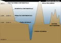 Oceanic basin it.png 800 × 563; 39 KB
-
 Oceanic basin nl.svg 1 001 × 705; 31 KB
-
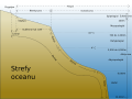
 Oceanic basin oc.png 1 001 × 705; 83 KB
-
 Oceanic basin pl.svg 1 001 × 705; 31 KB
-
 Oceanic basin ru.svg 1 001 × 705; 32 KB
-
 Oceanic basin tr.svg 1 001 × 705; 40 KB
-
 Oceanic basin uk.svg 1 001 × 705; 32 KB
-
 Oceanic basin-ar.svg 1 001 × 705; 104 KB
-
 Oceanic basin-fr.svg 1 001 × 705; 61 KB
-
 Oceanic basin-sv.svg 1 001 × 705; 32 KB
-
 Oceanic basin.svg 1 001 × 705; 9 KB
-
 Oceanic divisions es.svg 1 114 × 835; 23 KB
-
 Oceanic divisions pl.svg 1 114 × 835; 44 KB
-
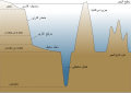
 Oceanic divisions ru.svg 1 114 × 835; 43 KB
-
 Oceanic divisions uk.svg 1 114 × 835; 43 KB
-
 Oceanic divisions-fr.svg 1 114 × 835; 51 KB
-
 Oceanic divisions-ja.svg 1 114 × 835; 55 KB
-
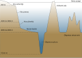
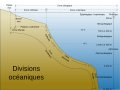
 Oceanic divisions.svg 1 114 × 835; 12 KB
-
 Oceanic-basin-th.png 1 001 × 705; 100 KB
-
 Oceanic-basin-th.svg 1 001 × 705; 38 KB
-
 Oceanic.Stripe.Magnetic.Anomalies.Scheme.fr.gif 260 × 190; 17 KB
-
 OpenSeaMap water depths by drowdsourcing-de.jpg 960 × 720; 68 KB
-
 Philippine plate tectonics - selected profiles.png 1 415 × 2 511; 185 KB
-
 Propagating Rift - Morphological Signature.png 1 616 × 544; 1,77 MB
-
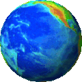 Rotating globe s.gif 139 × 139; 1,91 MB
-
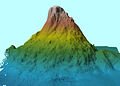 ROYAL NAVY SURVEY SHIP SPOTS UNDERWATER MOUNTAINS MOD 45158386.jpg 840 × 601; 282 KB
-
 Screenshot OpenSeaMap AT5-Karte Neustadt Lowrance Elite Ti 7.png 800 × 480; 186 KB
-
 Sea floor topography.gif 193 × 193; 288 KB
-
Seafloor bathymetry and biodiversity of Arafura Marine Park.webm 2 min 41 s, 1 920 × 1 080; 43,01 MB
-
 Sediment echosounder hg.png 1 000 × 702; 1,07 MB
-
 Europas Kolonien. 1 1885 (150827201).jpg 3 461 × 5 001; 10,26 MB


_Pacific_Oceanographic_Laboratories_(1968)_(20656430742).jpg)


.JPG)


.jpg)