Category:Baughurst
Aller à la navigation
Aller à la recherche
village britannique  | |||||
| Téléverser des médias | |||||
| Nature de l’élément | |||||
|---|---|---|---|---|---|
| Lieu | Basingstoke and Deane, Hampshire, Angleterre du Sud-Est, Angleterre | ||||
| Population |
| ||||
| Superficie |
| ||||
| site officiel | |||||
 | |||||
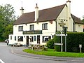
English: Baughurst is a civil parish in Hampshire England, near Tadley and 6 miles north of Basingstoke
Sous-catégories
Cette catégorie comprend 5 sous-catégories, dont les 5 ci-dessous.
A
- Axmansford (2 F)
H
- Haughurst Hill (4 F)
I
- Inhurst (7 F)
S
- St Stephen's Church, Baughurst (10 F)
W
- Wolverton Common (2 F)
Média dans la catégorie « Baughurst »
Cette catégorie comprend 210 fichiers, dont les 200 ci-dessous.
(page précédente) (page suivante)-
 A Neat Haystack near Coombe House Farm - geograph.org.uk - 28452.jpg 640 × 480 ; 165 kio
-
 A new wood emerges - geograph.org.uk - 2782449.jpg 640 × 480 ; 101 kio
-
 A Very Thick Thicket - geograph.org.uk - 5331494.jpg 1 600 × 1 200 ; 761 kio
-
 A very wet road junction north of West Heath - geograph.org.uk - 2912935.jpg 3 648 × 2 384 ; 1,62 Mio
-
 A339 east of Dorrel Wood - geograph.org.uk - 3105418.jpg 640 × 481 ; 57 kio
-
 A339, Wolverton - geograph.org.uk - 4151665.jpg 640 × 480 ; 370 kio
-
 Access to Sandford Wood - geograph.org.uk - 2782420.jpg 640 × 480 ; 113 kio
-
 Apple Tree Cottage, Pound Green - geograph.org.uk - 5331431.jpg 3 305 × 2 322 ; 2,07 Mio
-
 Approaching the A339 - geograph.org.uk - 2781917.jpg 640 × 480 ; 93 kio
-
 Badgers Wood.jpg 3 215 × 2 411 ; 1,43 Mio
-
 Baughurst church - geograph.org.uk - 4374765.jpg 640 × 480 ; 123 kio
-
 Baughurst Common School - geograph.org.uk - 1222270.jpg 640 × 426 ; 153 kio
-
 Baughurst Common School playing fields - geograph.org.uk - 1222266.jpg 640 × 427 ; 209 kio
-
 Baughurst Lane passes Church Green Farm - geograph.org.uk - 2912851.jpg 3 648 × 2 395 ; 1,53 Mio
-
 Baughurst Road - geograph.org.uk - 4881359.jpg 2 048 × 1 536 ; 1,54 Mio
-
 Baughurst Road - geograph.org.uk - 5330780.jpg 3 328 × 2 317 ; 2,19 Mio
-
 Baughurst Road, Pound Green - geograph.org.uk - 4898251.jpg 2 048 × 1 536 ; 1,14 Mio
-
 Baughurst Road, Pound Green - geograph.org.uk - 4898254.jpg 2 048 × 1 536 ; 1,52 Mio
-
 Baughurst, St. Stephen's Church - geograph.org.uk - 6261766.jpg 6 601 × 4 400 ; 5,34 Mio
-
 Baughurst, St. Stephen's Church - geograph.org.uk - 6261774.jpg 4 458 × 6 688 ; 6,22 Mio
-

-
 Bell Barrow - panoramio (1).jpg 3 872 × 2 592 ; 4,8 Mio
-
 Bell Barrow - panoramio (2).jpg 3 872 × 2 592 ; 4,84 Mio
-
 Belt of new trees - geograph.org.uk - 3469249.jpg 640 × 425 ; 95 kio
-
 Bend in the lane - geograph.org.uk - 2233764.jpg 640 × 475 ; 104 kio
-
 Blackthorn Close - geograph.org.uk - 2376137.jpg 640 × 541 ; 93 kio
-
 Bowl Barrow - panoramio.jpg 3 872 × 2 592 ; 4,79 Mio
-
 Brazenhead Lane - geograph.org.uk - 3465433.jpg 800 × 531 ; 163 kio
-
 Brazenhead Lane - geograph.org.uk - 3466451.jpg 640 × 425 ; 134 kio
-
 Brazenhead Lane - geograph.org.uk - 3466468.jpg 640 × 425 ; 121 kio
-
 Brazenhead Lane - geograph.org.uk - 3466504.jpg 640 × 425 ; 144 kio
-
 Brazenhead Lane - geograph.org.uk - 3466508.jpg 640 × 425 ; 128 kio
-
 Bridleway off Violet Lane - geograph.org.uk - 5330883.jpg 3 888 × 2 592 ; 3,69 Mio
-
 Church Farm - geograph.org.uk - 2705883.jpg 640 × 425 ; 191 kio
-
 Corner of Brock Copse - geograph.org.uk - 2782422.jpg 640 × 480 ; 119 kio
-
 Cottage near Wheathold - geograph.org.uk - 4784.jpg 640 × 480 ; 69 kio
-
 Cottage on Wolverton Townsend - geograph.org.uk - 4898258.jpg 1 884 × 1 280 ; 879 kio
-
 Cottage surrounded by wheat field - geograph.org.uk - 2541567.jpg 2 272 × 1 704 ; 2,08 Mio
-
 Country road, Browninghill Green, Hampshire - geograph.org.uk - 4774797.jpg 3 347 × 3 340 ; 6,78 Mio
-
 Crabbs Hill - A339 - geograph.org.uk - 2583752.jpg 640 × 421 ; 104 kio
-
 Damp spot on Violet Lane - geograph.org.uk - 4375213.jpg 640 × 480 ; 114 kio
-
 Disused pits - Brazenhead Lane - geograph.org.uk - 3466450.jpg 640 × 425 ; 134 kio
-
 Disused pits by Brazenhead Lane - geograph.org.uk - 3466464.jpg 640 × 425 ; 133 kio
-
 Drainage ditch - Brock Copse - geograph.org.uk - 2782426.jpg 480 × 640 ; 125 kio
-
 Driveway to Ewhurst House - geograph.org.uk - 2705410.jpg 640 × 427 ; 155 kio
-
 Edge of Brock Copse - geograph.org.uk - 2782512.jpg 640 × 480 ; 91 kio
-
 Entrance to Ewhurst House - geograph.org.uk - 2913565.jpg 3 648 × 2 736 ; 1,3 Mio
-
 Evidence of clearing - geograph.org.uk - 2782434.jpg 640 × 480 ; 112 kio
-
 Ewhurst Pond - geograph.org.uk - 2705420.jpg 640 × 427 ; 242 kio
-
 Ewhurst Pond - geograph.org.uk - 2705427.jpg 591 × 640 ; 326 kio
-
 Ewhurst Pond, Baughurst - geograph.org.uk - 6675211.jpg 1 024 × 683 ; 211 kio
-
 Exploring Brazenhead Lane - geograph.org.uk - 3466437.jpg 640 × 425 ; 117 kio
-
 Farmland beside Brazenhead Lane - geograph.org.uk - 3466472.jpg 640 × 425 ; 64 kio
-
 Farmland beside Brazenhead Lane - geograph.org.uk - 3466475.jpg 640 × 425 ; 80 kio
-
 Farmland by Brazenhead Lane - geograph.org.uk - 3466492.jpg 640 × 425 ; 70 kio
-
 Farmland by the A339 - geograph.org.uk - 3466441.jpg 640 × 425 ; 63 kio
-
 Farmland, Baughurst - geograph.org.uk - 1345718.jpg 640 × 480 ; 132 kio
-
 Farmland, Baughurst - geograph.org.uk - 2679956.jpg 640 × 480 ; 115 kio
-
 Farmland, Baughurst - geograph.org.uk - 2679971.jpg 640 × 480 ; 120 kio
-
 Farmland, Baughurst - geograph.org.uk - 2679983.jpg 640 × 480 ; 125 kio
-
 Farmland, Baughurst - geograph.org.uk - 6108291.jpg 1 024 × 768 ; 248 kio
-
 Farmland, Baughurst - geograph.org.uk - 6108316.jpg 1 024 × 768 ; 192 kio
-
 Farmland, Baughurst - geograph.org.uk - 6676902.jpg 1 024 × 683 ; 239 kio
-
 Field near Ham Farm - geograph.org.uk - 2541575.jpg 2 272 × 1 704 ; 2,31 Mio
-
 Footpath at Browning Hill - geograph.org.uk - 2541456.jpg 1 704 × 2 272 ; 2,61 Mio
-
 Footpath at Stony Heath - geograph.org.uk - 2705447.jpg 427 × 640 ; 201 kio
-
 Footpath in to Sandford Woods - geograph.org.uk - 2781876.jpg 640 × 480 ; 121 kio
-
 Footpath near Pudding Hill - geograph.org.uk - 2541562.jpg 1 704 × 2 272 ; 2,9 Mio
-
 Footpath to Pudding Hill - geograph.org.uk - 2781924.jpg 640 × 480 ; 97 kio
-
 Forest track - Brock Copse - geograph.org.uk - 2781879.jpg 640 × 480 ; 98 kio
-
 Former Methodist Chapel, Wolverton Common - geograph.org.uk - 3142424.jpg 1 563 × 1 134 ; 335 kio
-
 Former Methodist Mission Chapel, Haughurst - geograph.org.uk - 1993053.jpg 1 532 × 1 095 ; 464 kio
-
 Former Towns End Methodist Chapel - geograph.org.uk - 3142384.jpg 1 687 × 1 147 ; 427 kio
-
 Fun in the disused pit - geograph.org.uk - 3466507.jpg 640 × 425 ; 143 kio
-
 Fun in the woods - geograph.org.uk - 2782429.jpg 480 × 640 ; 124 kio
-
 Gallops near Kingsclere - geograph.org.uk - 5616601.jpg 3 264 × 2 448 ; 4,75 Mio
-
 Gallops on Watership Down - geograph.org.uk - 5616811.jpg 3 264 × 2 448 ; 4,51 Mio
-
 Garden of the Wellington Arms - geograph.org.uk - 2705895.jpg 640 × 423 ; 209 kio
-
 George and Dragon Inn, Towns End, Wolverton - geograph.org.uk - 3142934.jpg 1 716 × 1 147 ; 304 kio
-
 Ham Lane - Wolverton Road - geograph.org.uk - 2781902.jpg 640 × 480 ; 83 kio
-
 Ham Lane, Pound Green - geograph.org.uk - 4898266.jpg 2 048 × 1 536 ; 1,54 Mio
-
 Heading down Brazenhead Lane - geograph.org.uk - 3466454.jpg 640 × 425 ; 145 kio
-
 Heading down Brazenhead Lane - geograph.org.uk - 3466458.jpg 640 × 425 ; 136 kio
-
 Heading down Brazenhead Lane - geograph.org.uk - 3466459.jpg 640 × 425 ; 141 kio
-
 Heading south on Ham Lane - geograph.org.uk - 2781926.jpg 640 × 480 ; 103 kio
-
 Heath End Road - geograph.org.uk - 2455307.jpg 639 × 422 ; 71 kio
-
 Heath End Road - geograph.org.uk - 4886815.jpg 1 960 × 1 412 ; 1,05 Mio
-
 Heath Row Copse - geograph.org.uk - 5330826.jpg 1 600 × 1 067 ; 870 kio
-
 Hollybush Farm - geograph.org.uk - 2705437.jpg 640 × 426 ; 171 kio
-
 House on Wolverton Townsend - geograph.org.uk - 4898268.jpg 2 048 × 1 536 ; 908 kio
-
 Houses on Wolverton Townsend - geograph.org.uk - 4898289.jpg 2 048 × 1 536 ; 1,46 Mio
-
 Inhurst Farm - geograph.org.uk - 5330814.jpg 3 169 × 2 391 ; 2,46 Mio
-
 Inhurst Lane - geograph.org.uk - 4375234.jpg 640 × 480 ; 167 kio
-
 Inhurst Lane at Little Aldershot Lane junction - geograph.org.uk - 4375246.jpg 640 × 480 ; 111 kio
-
 Kingsclere from the air - geograph.org.uk - 5616607.jpg 3 264 × 2 448 ; 4,54 Mio
-
 Lane junction (Little Ham Farm) - geograph.org.uk - 2583749.jpg 640 × 480 ; 92 kio
-
 Lane junction near Baughurst House - geograph.org.uk - 2781923.jpg 640 × 480 ; 75 kio
-
 Let's stop here - geograph.org.uk - 2782515.jpg 640 × 480 ; 95 kio
-
 Lily Lake - geograph.org.uk - 2705431.jpg 433 × 640 ; 231 kio
-
 Lloyd's Lane - geograph.org.uk - 4815826.jpg 640 × 426 ; 61 kio
-
 Lloyd's Lane - geograph.org.uk - 4820413.jpg 640 × 405 ; 75 kio
-
 Lloyds Lane becomes Ewhurst Road - geograph.org.uk - 2913552.jpg 3 336 × 2 434 ; 1,56 Mio
-
 Lloyds Lane north of the A339 - geograph.org.uk - 2913727.jpg 3 425 × 2 520 ; 1,19 Mio
-
 Logs and Daffodils - geograph.org.uk - 5330824.jpg 3 528 × 2 327 ; 2,94 Mio
-
 Long Grove, Baughurst Common - geograph.org.uk - 5329589.jpg 3 386 × 2 174 ; 1,71 Mio
-
 Meeting of footpaths - geograph.org.uk - 2705478.jpg 640 × 429 ; 166 kio
-
 Minor obstruction - Brazenhead Lane - geograph.org.uk - 3466480.jpg 640 × 425 ; 127 kio
-
 Moyglare Farm - geograph.org.uk - 2705452.jpg 640 × 427 ; 230 kio
-
 New planting - Sandford Wood - geograph.org.uk - 2782437.jpg 640 × 480 ; 95 kio
-
 No way past - geograph.org.uk - 2705467.jpg 640 × 392 ; 202 kio
-
 Not a popular byway^ - geograph.org.uk - 3466433.jpg 640 × 425 ; 120 kio
-
 Not so many trees now - geograph.org.uk - 2782440.jpg 640 × 480 ; 94 kio
-
 Now you don't ... - geograph.org.uk - 2705841.jpg 640 × 427 ; 225 kio
-
 Now you see it ... - geograph.org.uk - 2705836.jpg 474 × 640 ; 339 kio
-
 Oak House - geograph.org.uk - 2705907.jpg 640 × 427 ; 221 kio
-
 Old fences ditches ^ dykes - geograph.org.uk - 3466502.jpg 640 × 425 ; 124 kio
-
 Outside the Wellington Arms - geograph.org.uk - 5342616.jpg 1 600 × 1 058 ; 545 kio
-
 Pair of swings - geograph.org.uk - 2782509.jpg 480 × 640 ; 133 kio
-
 Pasture, Baughurst - geograph.org.uk - 1775974.jpg 640 × 480 ; 116 kio
-
 Pasture, Baughurst - geograph.org.uk - 2679977.jpg 640 × 480 ; 123 kio
-
 Pasture, Baughurst - geograph.org.uk - 6675197.jpg 1 024 × 683 ; 253 kio
-
 Path around Brock Copse - geograph.org.uk - 2782423.jpg 640 × 480 ; 129 kio
-
 Path around Brock Copse - geograph.org.uk - 2782427.jpg 640 × 480 ; 129 kio
-
 Path in Sandford Wood - geograph.org.uk - 2782435.jpg 640 × 480 ; 110 kio
-
 Path leaving Sandford Wood - geograph.org.uk - 2782431.jpg 640 × 480 ; 125 kio
-
 Path towards Wolverton Farm - geograph.org.uk - 3466499.jpg 640 × 425 ; 129 kio
-
 Pine Tree, Long Grove - geograph.org.uk - 5329621.jpg 3 888 × 2 592 ; 3,03 Mio
-
 Pits (unmarked) on Brazenhead Lane - geograph.org.uk - 3466442.jpg 640 × 425 ; 129 kio
-
 Pitt Hall Cottage - geograph.org.uk - 4151716.jpg 640 × 480 ; 274 kio
-
 Pond at Browninghill Farm - geograph.org.uk - 2541470.jpg 2 272 × 1 704 ; 2,89 Mio
-
 Poppies at Ewhurst House - geograph.org.uk - 2705408.jpg 640 × 455 ; 240 kio
-
 Poppies at Ewhurst House - geograph.org.uk - 2705409.jpg 640 × 429 ; 228 kio
-
 Post Box - Ham Lane - geograph.org.uk - 2781906.jpg 640 × 480 ; 90 kio
-
 Power across the Hampshire Downs - geograph.org.uk - 3469245.jpg 640 × 425 ; 71 kio
-
 Power across the Hampshire Downs - geograph.org.uk - 3469255.jpg 640 × 425 ; 76 kio
-
 Power lines on the Downs - geograph.org.uk - 3466440.jpg 640 × 425 ; 64 kio
-
 Public footpath through Ewhurst Park - geograph.org.uk - 2705425.jpg 640 × 425 ; 219 kio
-
 Quiet day at the country pub - geograph.org.uk - 2781916.jpg 640 × 457 ; 69 kio
-
 Ramsdell Road at the junction of the A339 - geograph.org.uk - 4881344.jpg 2 048 × 1 536 ; 1,43 Mio
-
 Ramsdell Road, Wolverton - geograph.org.uk - 4898297.jpg 2 048 × 1 536 ; 1,45 Mio
-
 Rarely used - Brazenhead Lane - geograph.org.uk - 3466478.jpg 640 × 425 ; 121 kio
-
 Rarely used - Brazenhead Lane - geograph.org.uk - 3466485.jpg 640 × 425 ; 120 kio
-
 Rarely used - Brazenhead Lane - geograph.org.uk - 3466489.jpg 640 × 425 ; 119 kio
-
 Rider at the Wellington Arms - geograph.org.uk - 2705904.jpg 640 × 453 ; 219 kio
-
 Road, Baughurst - geograph.org.uk - 6675191.jpg 1 024 × 683 ; 218 kio
-
 Scarecrow, Baughurst church - geograph.org.uk - 4375612.jpg 640 × 480 ; 136 kio
-
 Sheep at Wellington Arms - geograph.org.uk - 2705890.jpg 640 × 427 ; 202 kio
-
 Sheep near the footpath - geograph.org.uk - 2705484.jpg 640 × 448 ; 209 kio
-
 Sheep separation - geograph.org.uk - 2705487.jpg 640 × 429 ; 186 kio
-
 Sheep separation - geograph.org.uk - 2705488.jpg 640 × 467 ; 231 kio
-
 Sign Post and Mail Box, Pound Green - geograph.org.uk - 5331446.jpg 1 600 × 1 262 ; 743 kio
-
 Small works yard by A339 - geograph.org.uk - 3469244.jpg 640 × 425 ; 81 kio
-
 Small works yard by A339 - geograph.org.uk - 3469253.jpg 640 × 425 ; 57 kio
-
 Spicers Lodge, Wolverton - geograph.org.uk - 4385199.jpg 640 × 480 ; 99 kio
-
 St Peter, Headley- from the east - geograph.org.uk - 3335522.jpg 640 × 474 ; 82 kio
-
 St Stephen's Parish Church, Baughurst - geograph.org.uk - 5331474.jpg 512 × 800 ; 138 kio
-
 Stile by the trees - geograph.org.uk - 2541556.jpg 2 272 × 1 704 ; 3,15 Mio
-
 The Badger's Wood, Baughurst, Hampshire - geograph.org.uk - 4774888.jpg 640 × 444 ; 82 kio
-
 The Badgers Wood - geograph.org.uk - 2912733.jpg 3 561 × 2 635 ; 1,11 Mio
-
 The Badgers Wood, Baughurst - geograph.org.uk - 5331425.jpg 3 239 × 2 479 ; 2,32 Mio
-
 The Hawthorns, Baughurst - geograph.org.uk - 5330775.jpg 3 642 × 2 076 ; 1,62 Mio
-
 The Wellington Arms, Baughurst - geograph.org.uk - 4881358.jpg 2 048 × 1 536 ; 1,49 Mio
-
 The Wolverton Road - geograph.org.uk - 2782418.jpg 640 × 480 ; 104 kio
-
 Track in Sandford Wood - geograph.org.uk - 2782455.jpg 640 × 480 ; 112 kio
-
 Tractors have right of way - geograph.org.uk - 2587174.jpg 640 × 443 ; 94 kio
-
 Trees mark the disused pit - geograph.org.uk - 3469254.jpg 640 × 425 ; 88 kio
-
 Trees tower over Lloyd's Lane - geograph.org.uk - 4820409.jpg 515 × 640 ; 115 kio
-
 Upper Farm, Farmhouse in Baughurst - geograph.org.uk - 28432.jpg 640 × 480 ; 252 kio
-
 Useful information - for a change^ - geograph.org.uk - 2782421.jpg 480 × 640 ; 82 kio
-
 View across the barley - geograph.org.uk - 2705461.jpg 640 × 403 ; 215 kio
-
 View along Brazenhead Lane - geograph.org.uk - 3466443.jpg 640 × 425 ; 143 kio
-
 View towards A339 - geograph.org.uk - 3469260.jpg 640 × 425 ; 89 kio
-
 View towards Coneygrove Copse - geograph.org.uk - 3469257.jpg 640 × 425 ; 95 kio
-
 View towards Coneygrove Copse - geograph.org.uk - 3469258.jpg 640 × 425 ; 93 kio
-
 View towards Hart's Copse - geograph.org.uk - 3466494.jpg 640 × 425 ; 66 kio
-
 View towards Hart's Copse - geograph.org.uk - 3466496.jpg 640 × 425 ; 76 kio
-
 View towards Hart's Copse - geograph.org.uk - 3469266.jpg 640 × 425 ; 66 kio
-
 View towards Wolverton Farm - geograph.org.uk - 3469256.jpg 640 × 425 ; 102 kio
-
 Violet Lane - geograph.org.uk - 4375201.jpg 640 × 480 ; 154 kio
-
 Violet Lane, Baughurst - geograph.org.uk - 5331421.jpg 3 648 × 2 736 ; 2,39 Mio
-
 Wellington Arms - geograph.org.uk - 2705900.jpg 640 × 427 ; 194 kio
-
 Wellington Arms near Baughurst - geograph.org.uk - 28439.jpg 640 × 480 ; 143 kio
-
 Where are you master^ - geograph.org.uk - 3466446.jpg 640 × 425 ; 129 kio
-
 Wolverton church - geograph.org.uk - 4385207.jpg 640 × 480 ; 98 kio
-
 Wolverton Playing Field - geograph.org.uk - 2782417.jpg 640 × 480 ; 96 kio
-
 Wolverton Playing Field - geograph.org.uk - 2782511.jpg 640 × 480 ; 125 kio
-
 Wolverton Road - geograph.org.uk - 2781897.jpg 639 × 464 ; 97 kio
-
 Wolverton Road - geograph.org.uk - 2781899.jpg 639 × 437 ; 82 kio
-
 Woodland beside Brazenhead Lane - geograph.org.uk - 3466510.jpg 640 × 425 ; 128 kio
-
 Woodland tunnel near to Heath End - geograph.org.uk - 599144.jpg 640 × 480 ; 176 kio
-
 Woodland, Baughurst - geograph.org.uk - 6108315.jpg 1 024 × 768 ; 347 kio
-
 Woodlands Road, Baughurst Common - geograph.org.uk - 5329577.jpg 3 403 × 2 177 ; 1,88 Mio
-
 Works at Ewhurst Pond - geograph.org.uk - 2705417.jpg 640 × 392 ; 205 kio
-
 Wrapped Bales near Tadley - geograph.org.uk - 28466.jpg 640 × 350 ; 132 kio
-
 Bishopswood Golf Course - geograph.org.uk - 28437.jpg 640 × 480 ; 157 kio
-
 Cornfield at Baughurst - geograph.org.uk - 28430.jpg 640 × 480 ; 137 kio
-
 Farmland and Paddock near Tadley - geograph.org.uk - 28464.jpg 640 × 480 ; 144 kio
-
 Farmland near Baughurst - geograph.org.uk - 28442.jpg 640 × 480 ; 149 kio
-
 Farmland near Stratton Manor - geograph.org.uk - 28451.jpg 640 × 480 ; 228 kio
-
 Farmland near Tadley - geograph.org.uk - 28468.jpg 640 × 480 ; 179 kio


.jpg)
.jpg)


_-_geograph.org.uk_-_2583749.jpg)


_on_Brazenhead_Lane_-_geograph.org.uk_-_3466442.jpg)


