Category:Beceite
Salta a la navigazzion
Và a cercà
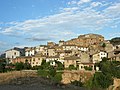
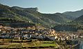
English: Beceite is a municipality located in the Matarraña/Matarranya comarca, province of Teruel, Aragon, Spain. According to the 2004 census (INE), the municipality has a population of 603 inhabitants. It is part of the Taula del Sénia free association of municipalities.
Español: Beceite (Beceit o Beseit en catalán) es un municipio de la provincia de Teruel, comunidad de Aragón, España, en la comarca de Matarraña. Tiene una población de 631 habitantes (INE 2008) y tiene una extensión de 96,72 km².
This is a category about a historical area listed in the Spanish heritage register of Bienes de Interés Cultural under the reference RI-53-0000638. |
| Posission del sogeto | | Mappa di tutte le coordinate: OpenStreetMap |
|---|
comune spagnolo .JPG)   | |||||
| Carega su un fail audio / video | |||||
| L'è un(a) | |||||
|---|---|---|---|---|---|
| Sit | Matarraña, Provincia de Teruel, Aragona, Spagna | ||||
| Léngoa ofiçiâ |
| ||||
| Capo de governo |
| ||||
| Formà da |
| ||||
| Popolazzion |
| ||||
| Area |
| ||||
| Altezza in sul mar |
| ||||
| sit ofizzial | |||||
 | |||||
Sotocategorie
Quella categoria chì la gh'ha 5 sot-categorie chì de sota, su un numer complessiv de 5.
F
- Fort de Cabrera (2 F)
P
- Parrizal de Beceite (35 F)
Fail in la categoria "Beceite"
Quella categoria chì la gh'ha denter 39 i fail riportad chì de sota, su un total de 39.
-
 Escut de Beseit.svg 570 × 980; 187 KByte
-
 Localització de Beseit.png 227 × 269; 18 KByte
-
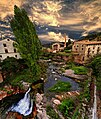 BECEITE (I) Los molinos (NO HDR) 3530851605 o.jpg 2 031 × 2 400; 2,3 MByte
-
 BECEITE (II) El puente (NO HDR) 3531051159 o.jpg 2 400 × 1 594; 2,31 MByte
-
 BECEITE - El puente.jpg 2 400 × 1 594; 2,31 MByte
-
 Beceite - Los molinos.jpg 2 031 × 2 400; 2,3 MByte
-
 Beceite - panoramio.jpg 640 × 480; 208 KByte
-
 Beceite 13-12-2007 - panoramio.jpg 850 × 638; 173 KByte
-
 Beceite, calle del lavadero. - panoramio.jpg 1 809 × 2 473; 2,08 MByte
-
 Besseit - panoramio.jpg 1 200 × 900; 465 KByte
-
 CAT700 2019 Aqüeducte de la séquia Major a Beseit.jpg 4 128 × 3 096; 3,49 MByte
-
 CAT700 2019 Camí del Parc Natural dels Ports, parada tècnica a la nit.jpg 4 128 × 3 096; 3,01 MByte
-
 Cova de la Dona a Lo Parrissal, Beseit (desembre 2012) - panoramio.jpg 3 648 × 2 736; 5,29 MByte
-
 Coves de Bertrol al riu Ulldemó, Beseit (desembre 2012) - panoramio.jpg 3 648 × 2 736; 4,95 MByte
-
 El Caro des de l'Arany, Beseit (desembre 2012) - panoramio.jpg 3 648 × 2 736; 4,21 MByte
-
 El Pont Nou Beceite.JPG 1 600 × 1 200; 566 KByte
-
 El Puente de Beceite nevado de noche 02.JPG 3 072 × 2 304; 2,93 MByte
-
 Embalasa de Pena near Beceite 13-12-2007 - panoramio.jpg 850 × 638; 147 KByte
-
 Forat d'Arany, Beseit (desembre 2012) - panoramio.jpg 3 648 × 2 736; 4,72 MByte
-
 Iglesia y Lonja de Beceite.jpg 2 136 × 3 216; 3,53 MByte
-
 Juniperus phoenicea - Flickr - S. Rae.jpg 5 472 × 3 648; 5,29 MByte
-
 Karte Gemeinde Beceite 2022.png 3 000 × 2 721; 1,41 MByte
-
 L'Ulldemó.jpg 2 048 × 1 536; 1,33 MByte
-
 LaFenellosa1.png 652 × 245; 431 KByte
-
 LaFenellosa2.png 509 × 200; 226 KByte
-
 Matarranya, Beseit (desembre 2012) - panoramio (1).jpg 3 648 × 2 736; 6,13 MByte
-
 Matarranya, Beseit (desembre 2012) - panoramio (2).jpg 3 648 × 2 736; 5,68 MByte
-
 Matarranya, Beseit (desembre 2012) - panoramio.jpg 2 736 × 3 648; 5,06 MByte
-
 MTN25-0521c1-1998-Beceite.jpg 7 755 × 5 453; 8,86 MByte
-
 MTN25-0521c1-2012-Beceite.jpg 7 493 × 5 185; 12,22 MByte
-
 Near Beceite 13-12-2007 - panoramio.jpg 850 × 638; 169 KByte
-
 Pas de l'Aüt al Matarranya, Beseit (desembre 2012) - panoramio.jpg 2 736 × 3 648; 4,36 MByte
-
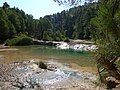
 Piscina natural de Beceite.jpg 7 281 × 4 659; 23,5 MByte
-
 Puente beceite.jpg 2 848 × 2 304; 797 KByte
-
 Puente de Beceite (TERUEL).JPG 3 456 × 2 304; 4,29 MByte
-
 Riu Ulldemó, Beseit (desembre 2012) - panoramio (1).jpg 3 648 × 2 736; 3,88 MByte
-
 Vista beceite y puertos.jpg 4 288 × 2 525; 840 KByte
-
 Vista Beceite.jpg 4 288 × 2 848; 5,46 MByte
-
 Vista panorámica Beceite.jpg 4 288 × 2 848; 5,78 MByte
_Los_molinos_(NO_HDR)_3530851605_o.jpg)
_El_puente_(NO_HDR)_3531051159_o.jpg)


_-_panoramio.jpg)
_-_panoramio.jpg)
_-_panoramio.jpg)


_-_panoramio.jpg)


_-_panoramio_(1).jpg)
_-_panoramio_(2).jpg)
_-_panoramio.jpg)


_-_panoramio.jpg)


.JPG)
_-_panoramio_(1).jpg)


