Category:Belle Fourche River
Zur Navigation springen
Zur Suche springen
Nebenfluss des Cheyenne River   | |||||
| Medium hochladen | |||||
| Ist ein(e) | |||||
|---|---|---|---|---|---|
| Ort |
| ||||
| Länge |
| ||||
| Quelle des Wasserlaufs | |||||
| Mündet in | |||||
| Einzugsgebiet |
| ||||
| Nebenfluss |
| ||||
 | |||||
English: Media related to the Belle Fourche River, an approximately 290-mile-long (470 km) river in Wyoming and South Dakota in the United States, that is a tributary of the Cheyenne River.
Unterkategorien
Es werden 2 von insgesamt 2 Unterkategorien in dieser Kategorie angezeigt:
In Klammern die Anzahl der enthaltenen Kategorien (K), Seiten (S), Dateien (D)
K
- Keyhole State Park (3 D)
Medien in der Kategorie „Belle Fourche River“
Folgende 6 Dateien sind in dieser Kategorie, von 6 insgesamt.
-
 Belle Fourche map 1.jpg 633 × 473; 105 KB
-
 Belle Fourche River 19A.JPG 849 × 566; 316 KB
-
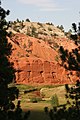 Belle Fourche River and sandstone cliffs (3911705561).jpg 2.336 × 3.504; 4,01 MB
-
 Devils Tower aerial.jpg 1.857 × 982; 2,16 MB
-
-
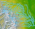 Wpdms nasa topo belle fourche river.jpg 300 × 250; 45 KB
.jpg)

