Category:Belton, Leicestershire
Aller à la navigation
Aller à la recherche
English: Belton, Leicestershire, is a small village in the Charnwood area. It lies very close to the town of Shepshed and further afield lies the main town of Charnwood borough, Loughborough. The village has a primary school, but children travel by bus to Shepshed High School once they pass into secondary school.
localité britannique du comté anglais de Leicestershire  | |||||
| Téléverser des médias | |||||
| Nature de l’élément | |||||
|---|---|---|---|---|---|
| Lieu | North West Leicestershire, Leicestershire, Midlands de l'Est, Angleterre | ||||
| Réputé identique à | Belton (page en doublon, paroisse civile) | ||||
 | |||||
Sous-catégories
Cette catégorie comprend 4 sous-catégories, dont les 4 ci-dessous.
G
- George Hotel, Belton (3 F)
- Grace Dieu Manor (1 F)
- Grace Dieu Priory (10 F)
Média dans la catégorie « Belton, Leicestershire »
Cette catégorie comprend 151 fichiers, dont les 151 ci-dessous.
-
 16 and 14 Long Street, Belton (geograph 7068761).jpg 1 024 × 768 ; 161 kio
-
 A kink in the road - geograph.org.uk - 3734667.jpg 1 200 × 900 ; 179 kio
-
 Ashby Road in Belton, Leicestershire - geograph.org.uk - 2260058.jpg 2 953 × 1 807 ; 2,21 Mio
-
 Ashby Road West (A512) - geograph.org.uk - 5046730.jpg 640 × 480 ; 96 kio
-
 Ashby Road, Belton - geograph.org.uk - 2086507.jpg 640 × 480 ; 55 kio
-
 Autumn colour by the A512 near Moyles Court House - geograph.org.uk - 3195904.jpg 768 × 1 024 ; 560 kio
-
 Belton C of E Primary School - geograph.org.uk - 5046749.jpg 640 × 480 ; 56 kio
-
 Belton Convenience Store - geograph.org.uk - 5046932.jpg 3 566 × 2 373 ; 1,26 Mio
-
 Belton Queens Head Pub ^ Hotel - geograph.org.uk - 2763621.jpg 640 × 480 ; 98 kio
-
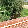
 Bridge across Grace Dieu Brook - geograph.org.uk - 2260124.jpg 3 213 × 2 212 ; 3,27 Mio
-
 Bridge over Grace Dieu Brook - geograph.org.uk - 2892776.jpg 4 000 × 3 000 ; 4,9 Mio
-
 Bromley Lane - geograph.org.uk - 3738288.jpg 1 200 × 900 ; 227 kio
-
 Bromley Lane comes to a sudden end - geograph.org.uk - 4368008.jpg 1 200 × 900 ; 190 kio
-
 Bromley Lane reduced to a footpath - geograph.org.uk - 4368019.jpg 1 200 × 900 ; 112 kio
-
 Bus shelter on A512 at junction with Gracedieu Lane - geograph.org.uk - 3195900.jpg 1 024 × 768 ; 570 kio
-
 Cattle grazing off National Cycle Route 15 - geograph.org.uk - 5046770.jpg 640 × 480 ; 76 kio
-
 Church of St John the Baptist, Belton - geograph.org.uk - 5046750.jpg 640 × 480 ; 50 kio
-
 Church Street, Belton - geograph.org.uk - 2894254.jpg 4 000 × 3 000 ; 4,59 Mio
-
 Church Street, Belton - geograph.org.uk - 5046751.jpg 640 × 480 ; 48 kio
-
 Cricket match on the recreation ground - geograph.org.uk - 2260110.jpg 2 503 × 1 539 ; 1,74 Mio
-
 Crop field and hedgerow - geograph.org.uk - 5046732.jpg 640 × 480 ; 68 kio
-
 Crop field east of Forest Lane - geograph.org.uk - 5046748.jpg 640 × 480 ; 61 kio
-
 Crop field just west of Forest Lane - geograph.org.uk - 5046741.jpg 640 × 480 ; 73 kio
-
 Crop field near Merril Grange - geograph.org.uk - 5046762.jpg 640 × 480 ; 62 kio
-
 Derelict farm - geograph.org.uk - 1340296.jpg 640 × 480 ; 94 kio
-
 Derelict farm and landlocked Barge - geograph.org.uk - 1340288.jpg 640 × 480 ; 76 kio
-
 Descending Forest Lane towards Ringing Hill - geograph.org.uk - 2260190.jpg 2 353 × 1 576 ; 1,57 Mio
-
 Double trough and fields - geograph.org.uk - 161566.jpg 640 × 480 ; 88 kio
-
 Elizabeth II postbox on Sadlers Wells, Belton - geograph.org.uk - 5046916.jpg 1 209 × 2 495 ; 549 kio
-
 Elizabeth II postbox outside Belton Convenience Store - geograph.org.uk - 5046929.jpg 1 092 × 2 097 ; 356 kio
-
 Farm building, Forest Fields Farm - geograph.org.uk - 5046743.jpg 640 × 480 ; 50 kio
-
 Farm Track North of Shepshed by Piper Wood - geograph.org.uk - 1340238.jpg 640 × 480 ; 127 kio
-
 Farm Track North of Shepshed by Piper Wood - geograph.org.uk - 1340248.jpg 640 × 480 ; 112 kio
-
 Farm Track North of Shepshed to Derelict farm - geograph.org.uk - 1340262.jpg 480 × 640 ; 126 kio
-
 Farm Track North of Shepshed to Derelict farm - geograph.org.uk - 1340267.jpg 640 × 480 ; 116 kio
-
 Farmland at Low Woods - geograph.org.uk - 2259852.jpg 1 959 × 1 318 ; 1,15 Mio
-
 Farmland close to Belton, Leicestershire - geograph.org.uk - 2260131.jpg 1 544 × 896 ; 508 kio
-
 Farmland north of Low Woods - geograph.org.uk - 2259985.jpg 2 206 × 2 084 ; 2 Mio
-
 Farmland south of Belton - geograph.org.uk - 2259945.jpg 2 795 × 2 188 ; 2,6 Mio
-
 Filled-in remains of the Charnwood Forest Canal - geograph.org.uk - 4433324.jpg 1 200 × 900 ; 290 kio
-
 Fishpool Grange - geograph.org.uk - 2260183.jpg 3 234 × 2 108 ; 2,85 Mio
-
 Footbridge over Grace Dieu Brook - geograph.org.uk - 4433370.jpg 1 200 × 900 ; 335 kio
-
 Footpath to Belton over ridge and furrow fields - geograph.org.uk - 4433238.jpg 1 200 × 900 ; 167 kio
-
 Footpath to Low Woods Lane - geograph.org.uk - 5046739.jpg 640 × 480 ; 88 kio
-
 Forest Field along Field Lane - geograph.org.uk - 2260175.jpg 2 847 × 2 024 ; 2,14 Mio
-
 Forest Fields Farm - geograph.org.uk - 5046745.jpg 640 × 480 ; 59 kio
-
 Forest Lane - geograph.org.uk - 5046734.jpg 640 × 480 ; 70 kio
-
 Forest Lane - geograph.org.uk - 5046747.jpg 640 × 480 ; 79 kio
-
 Forest Lane near Ringing Hill - geograph.org.uk - 2260196.jpg 3 179 × 1 863 ; 2,49 Mio
-
 Forest Lane south of Belton, Leicestershire - geograph.org.uk - 2260170.jpg 3 082 × 1 983 ; 2,49 Mio
-
 Former General Baptist Chapel, Belton - geograph.org.uk - 2894288.jpg 4 000 × 3 000 ; 4,47 Mio
-
 Good Farmers path to Woodlands Farm - geograph.org.uk - 1340314.jpg 640 × 480 ; 117 kio
-
 Grace Dieu bridge - geograph.org.uk - 1298610.jpg 640 × 426 ; 98 kio
-
 Grace Dieu Bridge - geograph.org.uk - 1540940.jpg 640 × 480 ; 137 kio
-
 Grace Dieu Brook - geograph.org.uk - 1302544.jpg 288 × 432 ; 120 kio
-
 Grace Dieu Brook - geograph.org.uk - 2260143.jpg 2 313 × 2 260 ; 2,32 Mio
-
 Grace Dieu Manor School and Chapel - geograph.org.uk - 4280573.jpg 4 320 × 3 240 ; 5,36 Mio
-
 Grace Dieu Ruins - geograph.org.uk - 4675426.jpg 1 600 × 1 200 ; 464 kio
-
 Grace Dieu Viaduct - geograph.org.uk - 1298532.jpg 640 × 426 ; 130 kio
-
 Grace Dieu Wood - geograph.org.uk - 1298600.jpg 640 × 426 ; 124 kio
-
 Grazing and hedgerow - geograph.org.uk - 5046746.jpg 640 × 480 ; 85 kio
-
 Grazing off National Cycle Route 15 - geograph.org.uk - 5046767.jpg 640 × 480 ; 64 kio
-
 Harborough Farm Driveway - geograph.org.uk - 323820.jpg 640 × 480 ; 109 kio
-
 Harlow Bros Farm - geograph.org.uk - 4367984.jpg 1 200 × 900 ; 109 kio
-

-
 Highfields House Driveway - geograph.org.uk - 240143.jpg 640 × 480 ; 124 kio
-
 House near Blackbrook Reservoir - geograph.org.uk - 2259710.jpg 2 126 × 1 579 ; 1,32 Mio
-
 Landlocked Barge - geograph.org.uk - 1340291.jpg 640 × 480 ; 104 kio
-
 Lay-by on Ashby Road - geograph.org.uk - 2785741.jpg 3 648 × 2 736 ; 3,84 Mio
-
 Lay-by outside Belton - geograph.org.uk - 1229001.jpg 640 × 480 ; 70 kio
-
 Long Street in Belton, Leicestershire - geograph.org.uk - 2260075.jpg 3 027 × 2 009 ; 2,42 Mio
-
 Long Street, Belton - geograph.org.uk - 2894268.jpg 4 000 × 3 000 ; 4,67 Mio
-
 Low Wood House Farm - geograph.org.uk - 2259917.jpg 2 008 × 1 472 ; 1,48 Mio
-
 Low Woods in northwest Leicestershire - geograph.org.uk - 2259869.jpg 2 742 × 1 533 ; 1,8 Mio
-
 Low Woods Lane near Ringing Hill - geograph.org.uk - 2259844.jpg 2 819 × 1 604 ; 2,02 Mio
-
 Low Woods Lane south of Belton - geograph.org.uk - 2260026.jpg 2 091 × 1 729 ; 1,53 Mio
-
 Merril Grange - geograph.org.uk - 3729617.jpg 1 200 × 900 ; 131 kio
-
 Micklin Farm on Low Woods Lane - geograph.org.uk - 2260049.jpg 3 264 × 2 448 ; 3,58 Mio
-
 Milepost in Belton Parish - geograph.org.uk - 240264.jpg 467 × 640 ; 73 kio
-
 Mixed letters on Long Street Belton - geograph.org.uk - 715528.jpg 640 × 480 ; 60 kio
-
 National Cycle Route 15 - geograph.org.uk - 5046764.jpg 640 × 480 ; 58 kio
-
 National Cycle Route 15 - geograph.org.uk - 5046769.jpg 640 × 480 ; 85 kio
-
 New bridge over Grace Dieu Brook - geograph.org.uk - 4375632.jpg 1 200 × 900 ; 211 kio
-
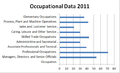 Occupational data for Belton from 2011.png 620 × 375 ; 17 kio
-
 Occupational Data of Belton 1881.png 511 × 336 ; 33 kio
-
 Old canal bed at Grace Dieu Priory - geograph.org.uk - 1996933.jpg 1 200 × 900 ; 385 kio
-
 Path by Derelict farm - geograph.org.uk - 1340306.jpg 640 × 480 ; 110 kio
-
 Piper Wood - geograph.org.uk - 1340205.jpg 640 × 480 ; 38 kio
-
 Piper Wood - geograph.org.uk - 1340257.jpg 640 × 480 ; 110 kio
-
 Piper Wood - geograph.org.uk - 1340279.jpg 640 × 480 ; 102 kio
-
 Piper Wood - geograph.org.uk - 1340284.jpg 640 × 480 ; 108 kio
-
 Piper Wood and path to Long Whatton - geograph.org.uk - 1340228.jpg 640 × 480 ; 104 kio
-
 Pond at Fishpool Grange - geograph.org.uk - 4433306.jpg 1 200 × 900 ; 312 kio
-
 Public footpath to Sandhole Lane - geograph.org.uk - 2259703.jpg 2 337 × 2 523 ; 2,49 Mio
-
 Round the Bend - geograph.org.uk - 323824.jpg 640 × 480 ; 77 kio
-
 Route 6 Crossroads - geograph.org.uk - 187078.jpg 640 × 480 ; 72 kio
-
 Route 6 towards Hallamford Road - geograph.org.uk - 323823.jpg 640 × 480 ; 110 kio
-
 Row of houses on Rempstone Road - geograph.org.uk - 2795788.jpg 3 648 × 2 736 ; 2,14 Mio
-

-
 Rusty Mary - 2 - geograph.org.uk - 1540898.jpg 480 × 640 ; 174 kio
-
 Rusty Mary - geograph.org.uk - 1298590.jpg 426 × 640 ; 84 kio
-
 Sadlers Wells, Belton - geograph.org.uk - 5046921.jpg 640 × 480 ; 55 kio
-
 Sign for the Queens Head, Belton - geograph.org.uk - 5046754.jpg 567 × 640 ; 56 kio
-
 Small field next to Grace Dieu Brook - geograph.org.uk - 2260152.jpg 2 997 × 1 768 ; 2,47 Mio
-
 Spring In Grace Dieu Wood - geograph.org.uk - 1302561.jpg 640 × 427 ; 165 kio
-
 St John the Baptist church - geograph.org.uk - 4843161.jpg 1 500 × 2 000 ; 273 kio
-
 Stile and path at Derelict farm - geograph.org.uk - 1340304.jpg 640 × 480 ; 108 kio
-
 The Charnwood Forest Canal - geograph.org.uk - 4433359.jpg 1 200 × 900 ; 382 kio
-
 The Charnwood Forest Railway - geograph.org.uk - 4450569.jpg 1 200 × 900 ; 402 kio
-
 The Cottage in Low Woods - geograph.org.uk - 2260011.jpg 2 493 × 1 507 ; 1,45 Mio
-
 The line of an old lane - geograph.org.uk - 4367995.jpg 1 200 × 900 ; 212 kio
-
 The Old Vicarage, Belton (geograph 7068751).jpg 1 024 × 768 ; 202 kio
-
 The Queens Head, Belton - geograph.org.uk - 5046753.jpg 640 × 480 ; 45 kio
-
 The start of a little-used field path - geograph.org.uk - 4450579.jpg 1 200 × 900 ; 273 kio
-
 The unused railway bridge, near Grace Dieu Priory - geograph.org.uk - 4675428.jpg 1 600 × 1 200 ; 684 kio
-
 Track to Middle Merril Grange Farm - geograph.org.uk - 5046766.jpg 640 × 480 ; 70 kio
-
 Un-named lane - geograph.org.uk - 4367989.jpg 1 200 × 900 ; 301 kio
-
 Unnamed lane - geograph.org.uk - 3738301.jpg 1 200 × 900 ; 349 kio
-
 Scaffold clad Church steeple - geograph.org.uk - 715526.jpg 640 × 475 ; 64 kio
-
 Vicarage Lane, Belton - geograph.org.uk - 2086502.jpg 640 × 480 ; 66 kio
-
 Westmeadow Brook - geograph.org.uk - 1228998.jpg 640 × 480 ; 154 kio
-
 Woodlands Farm - geograph.org.uk - 1340316.jpg 640 × 480 ; 74 kio
-
 Woodlands Farm field looking at Piper Wood - geograph.org.uk - 1340323.jpg 640 × 480 ; 102 kio
-
 A stable - geograph.org.uk - 323826.jpg 640 × 480 ; 112 kio
-
 Belton Baptist Church - geograph.org.uk - 192320.jpg 618 × 640 ; 72 kio
-

-
 Church Street - geograph.org.uk - 240262.jpg 640 × 480 ; 83 kio
-
 Corner of Gracedieu Lane - geograph.org.uk - 192319.jpg 640 × 480 ; 73 kio
-
 Dodgeford Lane - geograph.org.uk - 157405.jpg 640 × 480 ; 109 kio
-
 Dodgeford Lane sign - geograph.org.uk - 157408.jpg 482 × 640 ; 63 kio
-
 Field and a Farm - geograph.org.uk - 187084.jpg 640 × 480 ; 106 kio
-
 Footpath near the A42 - geograph.org.uk - 294049.jpg 640 × 480 ; 231 kio
-
 Forest Lane - geograph.org.uk - 323808.jpg 640 × 480 ; 61 kio
-
 Harborough Farm buildings - geograph.org.uk - 323822.jpg 640 × 480 ; 77 kio
-
 Hill Parks Farm - geograph.org.uk - 157417.jpg 640 × 480 ; 70 kio
-
 Hillcrest Research Station - geograph.org.uk - 157412.jpg 640 × 480 ; 72 kio
-
 Houses and milepost - geograph.org.uk - 240263.jpg 640 × 399 ; 63 kio
-
 Housing on Ashby Road Belton - geograph.org.uk - 715520.jpg 640 × 432 ; 56 kio
-
 Long Mere Farm - geograph.org.uk - 294043.jpg 640 × 480 ; 219 kio
-
 Long Mere Lane - geograph.org.uk - 294046.jpg 640 × 480 ; 226 kio
-
 Public right of way - geograph.org.uk - 157423.jpg 480 × 640 ; 96 kio
-
 Rempstone Road towards Ashby de la Zouch - geograph.org.uk - 240146.jpg 640 × 480 ; 75 kio
-
 Route 6 passes Harborough Farm - geograph.org.uk - 323818.jpg 640 × 480 ; 86 kio
-
 Route 6 Road - geograph.org.uk - 187073.jpg 640 × 480 ; 84 kio
-
 Shepshed Fields - geograph.org.uk - 240155.jpg 640 × 480 ; 67 kio
-
 Smile please^ - geograph.org.uk - 161571.jpg 640 × 374 ; 65 kio
-
 Stream - geograph.org.uk - 157415.jpg 640 × 480 ; 131 kio
-
 Top Merril Grange Farm - geograph.org.uk - 105706.jpg 640 × 480 ; 84 kio
-
 Track to Middle Merril Grange - geograph.org.uk - 161567.jpg 640 × 403 ; 60 kio
-
 Track towards Fishpool Grange - geograph.org.uk - 323809.jpg 640 × 480 ; 60 kio
-
 Works in the Trees - geograph.org.uk - 187082.jpg 640 × 480 ; 137 kio
.jpg)


_-_geograph.org.uk_-_5046730.jpg)


.jpg)


