Category:Bezirk Krems-Land
Salta a la navigazzion
Và a cercà
distretto austriaco .jpg)  | |||||
| Carega su un fail audio / video | |||||
| L'è un(a) | |||||
|---|---|---|---|---|---|
| Sit | Austria de Sota, Austria | ||||
| Capo de governo |
| ||||
| Popolazzion |
| ||||
| Area |
| ||||
 | |||||
Sotocategorie
Quella categoria chì la gh'ha 49 sot-categorie chì de sota, su un numer complessiv de 49.
!
*
A
B
F
G
H
J
K
L
- Locator maps of Bezirk Krems (67 F)
M
P
- Postcards of Bezirk Krems-Land (13 F)
R
S
- Stausee Dobra (15 F)
T
- Thurnberger Stausee (13 F)
W
Fail in la categoria "Bezirk Krems-Land"
Quella categoria chì la gh'ha denter 77 i fail riportad chì de sota, su un total de 77.
-
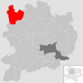
 Aggsbach in KR.PNG 645 × 645; 30 KByte
-
 Albrechtsberg an der Großen Krems in KR.png 554 × 583; 21 KByte
-
 Bergern im Dunkelsteinerwald in KR.PNG 645 × 645; 30 KByte
-
 Droß im Bezirk KR.png 645 × 645; 30 KByte
-
Droß im Bezirk KR.PNG 645 × 645; 30 KByte
-
 Droß in KR.png 554 × 583; 22 KByte
-
 Dürnstein im Bezirk KR.PNG 645 × 645; 30 KByte
-
Dürnstein in KR.PNG 645 × 645; 30 KByte
-
 Furth bei Göttweig im Bezirk KR.PNG 645 × 645; 30 KByte
-
Furth bei Göttweig in KR.PNG 645 × 645; 30 KByte
-
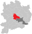
 Gedersdorf im Bezirk KR.PNG 645 × 645; 30 KByte
-
Gedersdorf in KR.PNG 645 × 645; 30 KByte
-
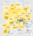
 Gemeinden im Bezirk Krems-Land.png 1 532 × 798; 157 KByte
-
 Gemeinden in der Stadtregion Krems.png 1 400 × 700; 119 KByte
-
 Gerichtsbezirk Krems an der Donau.svg 998 × 899; 94 KByte
-
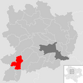
 Gföhl im Bezirk KR.PNG 645 × 645; 30 KByte
-
Gföhl in KR.PNG 645 × 645; 30 KByte
-
 Grafenegg in KR.png 554 × 583; 21 KByte
-
 Grafenegg in KR.PNG 645 × 645; 30 KByte
-
 Hadersdorf-Kammern im Bezirk KR.PNG 645 × 645; 30 KByte
-
Hadersdorf-Kammern in KR.PNG 645 × 645; 30 KByte
-
 Jaidhof im Bezirk KR.PNG 645 × 645; 30 KByte
-
 Jaidhof in KR.png 554 × 583; 22 KByte
-
Jaidhof in KR.PNG 645 × 645; 30 KByte
-
 Karte A Noe KR 2017.svg 1 050 × 970; 56 KByte
-
 Krumau am Kamp im Bezirk KR.PNG 645 × 645; 30 KByte
-
 Krumau am Kamp in KR.png 554 × 583; 22 KByte
-
Krumau am Kamp in KR.PNG 645 × 645; 30 KByte
-
 Langenlois im Bezirk KR.PNG 645 × 645; 30 KByte
-
Langenlois in KR.PNG 645 × 645; 30 KByte
-
 Leere Karte Gemeinden in KR.PNG 554 × 583; 26 KByte
-
 Lengenfeld im Bezirk KR.PNG 645 × 645; 30 KByte
-
 Lengenfeld in KR.png 554 × 583; 21 KByte
-
Lengenfeld in KR.PNG 645 × 645; 30 KByte
-
 Lichtenau im Waldviertel im Bezirk KR.PNG 645 × 645; 30 KByte
-
 Lichtenau im Waldviertel in KR.png 554 × 583; 22 KByte
-
Lichtenau im Waldviertel in KR.PNG 645 × 645; 30 KByte
-
 Maria Laach am Jauerling im Bezirk KR.PNG 645 × 645; 30 KByte
-
Maria Laach am Jauerling in KR.PNG 645 × 645; 30 KByte
-
 Mautern an der Donau im Bezirk KR.PNG 645 × 645; 30 KByte
-
Mautern an der Donau in KR.PNG 645 × 645; 30 KByte
-
 Municipalities Bezirk Krems.svg 569 × 611; 295 KByte
-
 Mühldorf im Bezirk KR.PNG 645 × 645; 30 KByte
-
Mühldorf in KR.PNG 645 × 645; 30 KByte
-
 Paudorf im Bezirk KR.PNG 645 × 645; 30 KByte
-
Paudorf in KR.PNG 645 × 645; 30 KByte
-
 Rastenfeld im Bezirk KR.PNG 645 × 645; 30 KByte
-
Rastenfeld in KR.PNG 645 × 645; 30 KByte
-
 Rohrendorf bei Krems in KR.png 554 × 583; 22 KByte
-
 Rohrendorf bei Krems in KR.PNG 645 × 645; 30 KByte
-
 Rossatz-Arnsdorf im Bezirk KR.PNG 645 × 645; 30 KByte
-
Rossatz-Arnsdorf in KR.PNG 645 × 645; 30 KByte
-
 Sankt Leonhard am Hornerwald in KR.png 554 × 583; 21 KByte
-
 Sankt Leonhard am Hornerwald in KR.PNG 645 × 645; 30 KByte
-
 Schild Dürnstein.JPG 4 000 × 3 000; 5,08 MByte
-
 Schönberg am Kamp im Bezirk KR.PNG 645 × 645; 30 KByte
-
Schönberg am Kamp in KR.PNG 645 × 645; 30 KByte
-
 Senftenberg im Bezirk KR.PNG 645 × 645; 30 KByte
-
 Senftenberg in KR.png 554 × 583; 22 KByte
-
Senftenberg in KR.PNG 645 × 645; 30 KByte
-

-
 Spitz an der Donau in KR.png 554 × 583; 21 KByte
-
 Spitz im Bezirk KR.PNG 645 × 645; 30 KByte
-
Spitz in KR.PNG 645 × 645; 30 KByte
-
St. Leonhard am Hornerwald im Bezirk KR.PNG 645 × 645; 30 KByte
-
 Stratzing im Bezirk KR.PNG 645 × 645; 30 KByte
-
 Stratzing in KR.png 554 × 583; 22 KByte
-
Stratzing in KR.PNG 645 × 645; 30 KByte
-
 Straß im Straßertale im Bezirk KR.PNG 645 × 645; 30 KByte
-
 Straß im Straßertale in KR.png 554 × 583; 21 KByte
-
Straß im Straßertale in KR.PNG 645 × 645; 30 KByte
-
 Straß in Straßertale in KR.png 454 × 369; 16 KByte
-
 Weinzierl am Walde im Bezirk KR.PNG 645 × 645; 30 KByte
-
 Weinzierl am Walde in KR.png 554 × 583; 22 KByte
-
Weinzierl am Walde in KR.PNG 645 × 645; 30 KByte
-
 Weißenkirchen in der Wachau im Bezirk KR.PNG 645 × 645; 30 KByte
-
Weißenkirchen in der Wachau in KR.PNG 645 × 645; 30 KByte


