Category:Bingen am Rhein
Vai alla navigazione
Vai alla ricerca
città tedesca    | |||||
| Carica un file multimediale | |||||
| Istanza di |
| ||||
|---|---|---|---|---|---|
| Luogo | circondario di Magonza-Bingen, Renania-Palatinato, Germania | ||||
| Situato sul mare / lago / fiume | |||||
| Ufficio turistico | |||||
| Capo del governo |
| ||||
| Popolazione |
| ||||
| Superficie |
| ||||
| Altezza sul mare |
| ||||
| sito web ufficiale | |||||
 | |||||
Sottocategorie
Questa categoria contiene le 35 sottocategorie indicate di seguito, su un totale di 35.
B
- Binger Inschrift (1 F)
- Binger Schiffswerft (3 F)
D
- D-AIAR (aircraft) (16 F)
E
G
H
- Hafenpark Bingen am Rhein (20 F)
J
N
P
- Pegel Bingen (2 F)
R
S
- Stolpersteine in Bingen am Rhein (191 F)
V
- Viewpoint Burg Klopp Bingen (12 F)
- Viewpoint Saint Roch chapel (12 F)
- Views of Bingen am Rhein (35 F)
W
Pagine nella categoria "Bingen am Rhein"
Questa categoria contiene un'unica pagina, indicata di seguito.
File nella categoria "Bingen am Rhein"
Questa categoria contiene 123 file, indicati di seguito, su un totale di 123.
-
 "Fliegen", sculpture in Bingen.jpg 4 000 × 3 000; 1,76 MB
-
 "St. Nikolaus I".jpg 3 648 × 2 736; 3,38 MB
-
 140 070-4 Bingen am Rhein.jpg 4 708 × 2 856; 8,65 MB
-
 20071009-DSC 0031.jpg 3 872 × 2 592; 4,64 MB
-
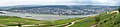
 201610 bingen rhein vom niederwald.jpg 4 000 × 3 000; 7,27 MB
-

-

-
 Altes Zollamt.jpg 4 000 × 3 000; 5,91 MB
-
 Auenlandschadt Bingerbrück 246-47-fLh.jpg 2 430 × 1 223; 859 KB
-
 Ausoniusweg Start.jpg 2 496 × 1 664; 1,62 MB
-
 BIN-DA205.jpg 5 312 × 2 988; 5,3 MB
-
 Bingen - 50Pf. 1918.jpg 1 011 × 1 446; 651 KB
-
 Bingen 2009-08-06 16.jpg 3 888 × 2 592; 1,13 MB
-
 Bingen 2018.JPG 8 192 × 1 856; 10,44 MB
-
 Bingen am Rhein - no-nb digifoto 20160211 00032 NB NS NM 00086b.jpg 2 872 × 2 890; 880 KB
-
 Bingen am Rhein - panoramio.jpg 4 600 × 2 304; 2,74 MB
-
 Bingen am Rhein - The Rhine Riverbank - geo.hlipp.de - 27381.jpg 640 × 425; 76 KB
-
 Bingen am Rhein - Zollamt Restaurant - geo.hlipp.de - 27383.jpg 640 × 425; 101 KB
-
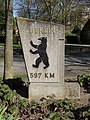 Bingen am Rhein Berlin-Meilenstein Hindenburganlage (Bild 1).jpg 3 672 × 4 896; 6,59 MB
-
 Bingen am Rhein Bildstock bei Mariahilfstraße 14 (Bild 2).jpg 3 672 × 4 896; 5,49 MB
-
 Bingen am Rhein Haustür an Amtsstraße 15 (Bild 1).jpg 3 672 × 4 896; 5,17 MB
-
 Bingen am Rhein in MZ.svg 349 × 241; 224 KB
-
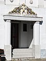 Bingen am Rhein Portalbekrönung Dr.-Sieglitz-Straße 17 (Bild 2).jpg 3 672 × 4 896; 4,95 MB
-
 Bingen am Rhein Villa Am Burggraben 3 (Bild 2).jpg 4 896 × 3 672; 10,52 MB
-
 Bingen am Rhein Wohnhaus Mariahilfstraße 1 (Bild 1).jpg 3 672 × 4 896; 6,12 MB
-
 Bingen am Rhein Wohnhäuser Schloßbergstraße 41-43 (Bild 1).jpg 4 896 × 3 672; 6,4 MB
-
 Bingen am Rhein, Nahemündung 20151007-SAM 0992.jpg 5 472 × 3 648; 18,53 MB
-
 Bingen am Rhein; Stadtplan a.jpg 4 585 × 2 900; 2,14 MB
-
 Bingen am Rhein; Uferpromenade a.jpg 3 456 × 2 400; 1,22 MB
-
 Bingen am Rhein; Uferpromenade b.jpg 3 369 × 5 100; 5,04 MB
-
 Bingen am Rhein; Uferpromenade c.jpg 5 184 × 3 456; 6,14 MB
-
 Bingen Burg Klopp - geo.hlipp.de - 21486.jpg 480 × 640; 78 KB
-
 Bingen Burg Klopp - panoramio.jpg 3 831 × 2 395; 3,73 MB
-
 Bingen Federle 1845.jpg 3 000 × 2 183; 5,4 MB
-
 Bingen Nahemündung 213-dh.jpg 1 612 × 1 197; 579 KB
-
 Bingen Rhein Ehrenfels 2016-03-26-17-51-00.jpg 4 896 × 3 264; 12,3 MB
-
 Bingen Rheinufer Büste Victor Hugo.jpg 3 000 × 4 000; 3,43 MB
-
 Bingen StMartin basilica Burg Klopp.jpg 1 600 × 1 200; 718 KB
-

-

-
 Bingen – die Burg Klopp ist Teil des UNESCO-Welterbes Oberes Mittelrheintal - panoramio.jpg 3 240 × 4 320; 3,54 MB
-
 Bingen – im Hintergrund Rheinhessen - panoramio.jpg 3 335 × 1 870; 2,44 MB
-
 Bingen – Speisenmarkt – Weinfestbrunnen 1680 - panoramio.jpg 3 240 × 4 320; 2,32 MB
-
 Bingen, park along the Rhine.jpg 4 000 × 3 000; 4,12 MB
-
 Bingen, the pharmacy "Adler Apotheke".JPG 1 701 × 2 551; 1 MB
-
 Bingen- Rathaus (Bingen Town Hall) - geo.hlipp.de - 21476.jpg 640 × 480; 72 KB
-
 Binger Bleistift.jpg 3 504 × 2 336; 2,98 MB
-
 Binger Loch 2011 1.JPG 3 932 × 2 760; 2,63 MB
-
 Binger Loch.JPG 1 536 × 1 024; 1,14 MB
-

-
 Brunnen am Speisemarkt, Bingen - geo.hlipp.de - 21483.jpg 478 × 640; 72 KB
-

-
 Cycle track along the Rhine west of Bingen - geo.hlipp.de - 21461.jpg 480 × 640; 124 KB
-
De-Bingen.ogg 1,7 s; 17 KB
-
 Denkmal am Binger Loch Nahaufnahme 2012 05 13 15 04 23.JPG 3 264 × 4 928; 8,52 MB
-
 Der Hafen im Bingen - geo.hlipp.de - 21424.jpg 640 × 480; 104 KB
-
 Die Nahe im Rhein.jpg 1 600 × 1 200; 287 KB
-
 Die Nahe in Bingen (The Nahe at Bingen) - geo.hlipp.de - 21480.jpg 640 × 480; 59 KB
-
 Don't do it!! - geo.hlipp.de - 21428.jpg 480 × 640; 73 KB
-
 E. Hoefer, Bingen, nach Emminger, Lithographie, D1390.jpg 1 050 × 704; 277 KB
-
 Ehrenfels1900.jpg 3 474 × 2 570; 3,74 MB
-
 Einwohnerentwicklung von Bingen am Rhein.svg 800 × 400; 50 KB
-
 Enlargement-Rheinburgenweg (section) - Wikivoyage-20140207.png 448 × 655; 36 KB
-
 ETH-BIB-Bingen und Bingerloch -Binger Loch--Dia 247-02473.tif 3 647 × 2 740; 28,68 MB
-
 Football ground near the Rhine at Kempten - geo.hlipp.de - 21423.jpg 640 × 480; 78 KB
-
 Fountain near the station at Bingen - geo.hlipp.de - 21482.jpg 640 × 480; 98 KB
-
 Geisenheim und Ingelheim - panoramio.jpg 4 000 × 2 056; 2,56 MB
-
 Graureiher flug.jpg 3 872 × 2 592; 6,16 MB
-
 Heilige Berta -1532 Holzschnitt v. Jacob Köbel.jpg 600 × 1 003; 501 KB
-
 Heiliger Rupert-1532 Holzschnitt v. Jacob Köbel.jpg 600 × 891; 415 KB
-
 Heilkräutergarten Hildegard-Forum Rochusberg Bingen (01).jpg 5 184 × 3 456; 5,26 MB
-
 Hildegard-1532 Holzschnitt v. Jacob Köbel.jpg 600 × 781; 306 KB
-
 Historienweg Rüdesheim Rhein small.jpg 2 951 × 590; 545 KB
-
 HPM 211 – Bingen, nach Emminger.jpg 2 397 × 2 161; 591 KB
-
 Jay Gard, Touristic Hint, Nah und Fern, Skulpturen-Triennale Bingen, 2017.jpg 1 024 × 724; 674 KB
-

-
 Ke wapp.jpg 153 × 155; 7 KB
-
-
 La Nahe gelée à Bingen (Rhénanie-Palatinat) (6880647325).jpg 617 × 468; 59 KB
-
 Loading a fire service launch near Bingen - geo.hlipp.de - 21422.jpg 640 × 480; 96 KB
-
 Logo Stadt Bingen am Rhein.svg 782 × 67; 10 KB
-

-
 Mine-shaft entrance, - geo.hlipp.de - 21475.jpg 640 × 480; 121 KB
-
 MittelrheinNahe.jpg 640 × 480; 97 KB
-
 Mixed appetizers, Bingen.jpg 4 000 × 3 000; 3,2 MB
-
 Mouth of the Nahe, from Rüdesheim.jpg 3 192 × 2 394; 1,32 MB
-
 Mäuseturm bei Bingen.jpg 3 648 × 2 736; 3,57 MB
-
 Mäuseturm im Rhein bei Bingen.jpg 3 648 × 2 736; 3,25 MB
-
 Nahe. (50365888223).jpg 3 501 × 5 252; 9,45 MB
-
 Panorama de Bingen.jpg 4 146 × 919; 1,23 MB
-
 Panorama-bingen-am-rhein-d24c4006-8ab1-49f3-9853-84e26db9f366.jpg 3 000 × 468; 310 KB
-
 Path alongside the haven at Bingen - geo.hlipp.de - 21426.jpg 480 × 640; 117 KB
-
 Plan der Stadt Bingen.jpg 5 527 × 3 686; 4,99 MB
-
 Rainbow Bingen.jpg 1 600 × 1 151; 435 KB
-
 Rhein in Flammen, boats and Bingen.jpg 3 781 × 2 836; 1,22 MB
-

-
 Rheingau-Taunus-Kreis - Bingen Scenery - geo.hlipp.de - 27277.jpg 640 × 425; 88 KB
-
 Rheingau-Taunus-Kreis - Klopp Castle - geo.hlipp.de - 27371.jpg 640 × 425; 85 KB
-
 Rose flowers, Bingen.jpg 3 219 × 2 414; 1,61 MB
-
 Rüdesheim am Rhein - panoramio.jpg 2 000 × 612; 108 KB
-
 Rüdesheim Historienweg 582-84kh.jpg 3 691 × 1 093; 1,09 MB
-
 Rüdesheim und Geisenheim im Rheingau - panoramio.jpg 3 633 × 1 996; 2,37 MB
-
 Schiff Bingen.jpg 3 836 × 2 581; 3,48 MB
-
 Storchennest (Bingen am Rhein).jpg 600 × 2 015; 830 KB
-
 Streitäxte der Becherkultur - RLM Bonn.jpg 5 104 × 3 745; 7,08 MB
-
 SunriseBingenJune2010.jpg 3 492 × 2 256; 2,64 MB
-
 SunriseBingenJune2010Wallpaper.jpg 1 920 × 1 200; 902 KB
-
 Tombleson Bingen.jpg 2 136 × 1 643; 1,44 MB
-
 Trans regio in Bingen 001.jpg 2 560 × 1 920; 3,46 MB
-
 Tz1166 Taufe.jpg 568 × 426; 55 KB
-

-
 View from the ferry port, Bingen - geo.hlipp.de - 21427.jpg 480 × 640; 64 KB
-
 View to Bingen Castle - geo.hlipp.de - 21479.jpg 640 × 480; 76 KB
-

-

-
 Wahrschauer Anton Berges.jpg 2 932 × 1 731; 491 KB
-
 Wappen SSV Bingen.jpg 164 × 243; 14 KB
-
 Wappen von Bingen.png 372 × 520; 303 KB
-
 Weinbergsterrassen.jpg 1 536 × 1 024; 1,13 MB
-
 ライン川 - panoramio (2).jpg 3 264 × 2 448; 1,94 MB
-
 ライン川とクロップ城 - panoramio.jpg 3 264 × 1 711; 1,45 MB
-
 宾根1 - panoramio.jpg 2 048 × 1 150; 513 KB
-
 涂鸦 - panoramio.jpg 2 048 × 1 150; 814 KB


_-_geo.hlipp.de_-_21415.jpg)
_-_geo.hlipp.de_-_21429.jpg)


.jpg)
.jpg)
.jpg)
.jpg)
.jpg)
.jpg)
.jpg)


.jpg)
.jpg)


_-_geo.hlipp.de_-_21476.jpg)


_-_geo.hlipp.de_-_21487.jpg)


_-_geo.hlipp.de_-_21480.jpg)


_-_Wikivoyage-20140207.png)


.jpg)


_(6880647325).jpg)

_-_geo.hlipp.de_-_21452.jpg)


.jpg)


_(6874506353).jpg)


.jpg)
_(6880647345).jpg)


.jpg)


.jpg)