Category:Biogeography
跳转到导航
跳转到搜索
study of the distribution of species and ecosystems in geographic space and through geological time  | |||||
| 上传媒体 | |||||
| 读音 (音频文件) | |||||
|---|---|---|---|---|---|
| 隶属于 | |||||
| 上级分类 | |||||
| 所属实体 |
| ||||
| |||||
English: This category is intended to contain media and the like about the distribution of biological entities in space (and time).
子分类
本分类有以下32个子分类,共有32个子分类。
#
A
- Anthropization (4 F)
B
C
- C. Hart Merriam papers (74 F)
- CORINE Land Cover (28 F)
D
- Jean-Marc Drouin (1 F)
E
G
I
- Insular biogeography (3 F)
P
- Phylogeography (4 F)
S
T
W
Z
分类“Biogeography”中的媒体文件
以下97个文件属于本分类,共97个文件。
-
-
 Ecozone-Biocountry-Afrotropic-legend.svg 175 × 290;106 KB
-

-

-
-

-

-

-

-

-

-

-
-

-
 Analise de endemicidade.jpg 497 × 375;99 KB
-
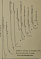
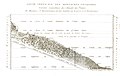
 Annales de géographie, Tome XXXVIII, 1929.djvu 2,867 × 4,182,673页;51.09 MB
-
 Art naturaliste C.M.jpg 9,105 × 11,443;9.19 MB
-
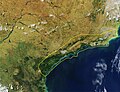
 Bahia coastal forests WWF Satelite.jpg 3,265 × 4,345;4.52 MB
-
 Bahia Mangroves WWF.jpg 2,580 × 3,440;2.01 MB
-
 Bergwiese-Salzburgerland-2008-Thomas Huntke.jpg 900 × 600;393 KB
-
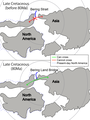
 Bering Land Bridge in Late Cretaceous.png 2,594 × 1,480;320 KB
-
 Biomes-percentage.jpg 600 × 361;38 KB
-
 Burak Yedekçi.jpg 513 × 409;39 KB
-
-
-

-

-
-

-
-
 Chicken domestication and dispersal.svg 8,750 × 4,232;267 KB
-
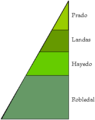
 Clibeticas.png 377 × 330;2 KB
-
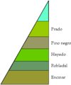
 Clicanarias.png 316 × 330;2 KB
-
 Clicantabirca.png 262 × 330;2 KB
-
 Clicentral.png 272 × 330;2 KB
-
 Cliinverso.png 272 × 330;2 KB
-
 Clipirineo.png 276 × 330;2 KB
-
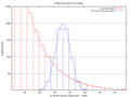
 Computacao biogeografica especies.png 561 × 421;13 KB
-
 Computacao biogeografica framework.png 960 × 720;43 KB
-
 Computacao biogeografica griewank.png 561 × 421;36 KB
-
 Computacao biogeografica individuos.png 561 × 421;16 KB
-
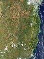 Corredor Central Sul da Bahia - Espírito Santo.jpg 4,186 × 5,581;5.73 MB
-

-
 Eilandtheorie2.JPG 285 × 882;36 KB
-
 Entimus distribution.png 1,200 × 1,573;86 KB
-
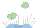
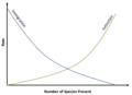 Equilibrium Model for Number of Species on an Island.png 785 × 568;47 KB
-
 Estratificación de la biocenosis.png 399 × 296;3 KB
-
 Eustala madddux dorsal view.tif 3,288 × 2,004;50.28 MB
-
 Eustala maddux dorsal view.tif 3,276 × 2,268;56.69 MB
-
 Fluessiger Wald.jpg 1,480 × 984;808 KB
-
 G barretti distribution map (2015).png 610 × 552;509 KB
-
 Garrigue herault.jpg 700 × 462;103 KB
-
 Gedibiomass gedi 2021 lrg.jpg 2,913 × 1,942;2.74 MB
-
 Gedibiomass gedi 2021.jpg 720 × 545;459 KB
-
 Gediindig gedi 2021 lrg.jpg 2,913 × 1,942;2.67 MB
-
 Gediindig gedi 2021.jpg 720 × 545;497 KB
-
 Geodispersal at Bering Land Bridge.png 2,074 × 2,771;415 KB
-
 Globales Profil - Höhenstufen der Vegetation.png 2,356 × 1,312;397 KB
-
 GRIS.jpg 598 × 624;57 KB
-
 Hawaii speciation (Drosophila and Cyanea colonization).png 2,000 × 1,298;9.91 MB
-
 Hawaii speciation (Drosophila colonization).png 2,000 × 1,298;1.52 MB
-
 Horizontes suelo.png 244 × 290;1 KB
-
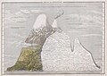
 Humboldt1805-chimborazo.jpg 2,155 × 1,494;259 KB
-

-
 Ilha Grande Mangroves WWF.jpg 3,358 × 2,584;1.74 MB
-
 Insular Biogeography (Distance).png 960 × 720;36 KB
-
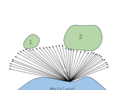 Insular Biogeography (Size).png 960 × 720;72 KB
-
 Island-biogeography.jpg 1,909 × 1,684;159 KB
-
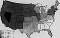
 Karte Vegetation USA.jpg 790 × 555;102 KB
-
 Landscape and seascape relationships of ecosystem functional groups.webp 1,767 × 1,997;351 KB
-

-
 Marine-biogeographical-realm.png 961 × 481;222 KB
-
 Museo de Ciencias Naturales, Guadalcázar 004.JPG 640 × 480;80 KB
-
 Offene Gartenpforte 2008.jpg 280 × 210;37 KB
-
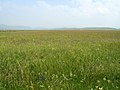 Prairie en Chine du nord.jpg 1,600 × 1,200;575 KB
-

-
 Rio Piranhas & São Francisco Mangroves WWF.jpg 2,257 × 2,934;1.43 MB
-

-
 Serra do Mar Corredor.jpg 5,886 × 4,528;6.91 MB
-
 Serra Negra - Bezerros - PE - Brazil.jpg 800 × 600;46 KB
-
 Sociabilidad de la biocenosis.png 753 × 293;7 KB
-
 Soulavie Chart.jpg 3,190 × 2,030;2.84 MB
-
 Szvert gr.png 640 × 480;11 KB
-
 Temperate broadleaf and mixed forests.jpg 973 × 535;50 KB
-
 The distribution of paraves in Early Cretaceous.png 3,209 × 1,812;368 KB
-
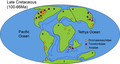 The distribution of paraves in Late Cretaceous.png 3,480 × 1,853;406 KB
-
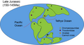 The distribution of paraves in Late Jurassic.png 3,311 × 1,779;283 KB
-
 Tiger Bush Niger Corona 1965-12-31.jpg 1,000 × 1,000;545 KB
-
 Typ geobiocenu.svg 940 × 431;89 KB
-
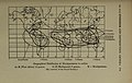
 Vavilov-centers updated.jpg 1,000 × 614;75 KB
-
 Ylistrum balloti (Bernardi, 1861) world distribution map.jpg 6,600 × 7,200;6.24 MB
-
 Zonas biogeográficas Neártica y neotropical.png 1,348 × 1,452;300 KB
-
 Біогеографічні регіони Європи .png 5,846 × 4,133;2.71 MB
-
 Біогеографічні регіони Європи.png 5,846 × 4,133;2.06 MB
-
 Біогеографічні регіони України .png 5,846 × 5,846;1.61 MB
-
 Біогеографічні регіони України- .png 5,846 × 5,846;3.19 MB
-
 Біогеографічні регіони України.png 5,846 × 5,846;1.13 MB


_(14591994339).jpg)
_(14592000359).jpg)
_(14592008249).jpg)
_(14592023738).jpg)
_(14592032358).jpg)
_(14592037778).jpg)
_(14592173647).jpg)
_(14592184457).jpg)
_(14776317594).jpg)
_(14778312492).jpg)
_(14798541433).jpg)
_(14798550003).jpg)


_(1871)_(20407557928).jpg)
_(1871)_(20411408128).jpg)
_(1871)_(20413942669).jpg)
_(1886)_(20404327740).jpg)
_(1886)_(20404636258).jpg)
_(1886)_(20409567719).jpg)


.jpg)


.png)


.png)
.png)


.png)
.png)


_world_distribution_map.jpg)


_(1886)_(19970277274).jpg)