Category:Black Mesa (Apache-Navajo Counties, Arizona)
Vai alla navigazione
Vai alla ricerca
mountainous mesa of Arizona  | |||||
| Carica un file multimediale | |||||
| Istanza di | |||||
|---|---|---|---|---|---|
| Prende il nome da |
| ||||
| Luogo | Arizona, Stati Uniti d'America | ||||
 | |||||
English: Black Mesa — a mountainous mesa in northeastern Arizona, split between Apache County—Navajo County and the Hopi Reservation—Navajo Nation Reservation.
- In the physiographic Navajo section of the Colorado Plateau, with the highest point 8,168 feet (2,490 m) in elevation. U.S. Route 160 crosses the mesa.
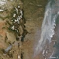
- Its dark appearance is from numerous coal seams running through it, extensively strip mined at the Kayenta Mine since the 1960s, causing the Black Mesa Peabody Coal debate.
Sottocategorie
Questa categoria contiene le 3 sottocategorie indicate di seguito, su un totale di 3.
B
L
- Laguña Creek (4 F)
File nella categoria "Black Mesa (Apache-Navajo Counties, Arizona)"
Questa categoria contiene 15 file, indicati di seguito, su un totale di 15.
-
 Kayenta mine permit area and PWCC lease areas map.png 1 197 × 739; 561 KB
-

-
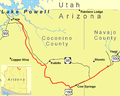 Black Mesa and Lake Powell RR Map.png 1 500 × 1 200; 109 KB
-
 Black Mesa near Chilchinbito.jpg 3 264 × 2 448; 10,34 MB
-
 Black Mesa, South of Kayenta, Arizona (14475220916).jpg 4 000 × 3 000; 2,45 MB
-
 Black Mesa, South of Kayenta, Arizona (14475224526).jpg 4 000 × 3 000; 2,43 MB
-
 Coal Mine Canyon in the Arizona Painted Desert.jpg 1 024 × 819; 268 KB
-
 Coal mine for Navajo Generating Station 2008.jpg 3 264 × 2 448; 10,35 MB
-
 Grand Canyon satelliet.jpg 2 600 × 2 000; 1 004 KB
-
 Map of the Navajo Volcanic Fields.jpg 1 280 × 1 467; 568 KB
-
 NE AZ-NW NM NASA.jpg 990 × 830; 645 KB
-
 Old Pick-up (8796366513).jpg 2 048 × 1 536; 462 KB
-
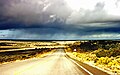 Rain in the desert, Arizona near the Black Mesa.jpg 1 710 × 1 074; 1,2 MB
-
 Tséyiʼ sunset (16134586787).jpg 3 264 × 2 448; 2,02 MB
-
 Wallow fire satphoto, June 7, 2011.jpg 720 × 720; 222 KB


.jpg)
.jpg)


.jpg)

.jpg)

Categorie:
- Mesas of Arizona
- Mountain ranges of Arizona
- Landforms on the Navajo Nation
- Landforms of Apache County, Arizona
- Landforms of Navajo County, Arizona
- Coal mining in Arizona
- Colorado Plateau Navajo section
- Colorado Plateau region of Arizona
- San Rafael Group in Arizona
- Locations along U.S. Route 160 in Arizona
- Hopi Reservation
- Warm Springs Wilderness