Category:Blue Mesa Dam
Zur Navigation springen
Zur Suche springen
dam in Cimarron, Gunnison County, Colorado, USA  | |||||
| Medium hochladen | |||||
| Ist ein(e) | |||||
|---|---|---|---|---|---|
| Liegt in Schutzgebiet | |||||
| Ort | Gunnison County, Colorado | ||||
| Liegt am oder im Gewässer | |||||
| Eigentümer/Besitzer | |||||
| Betreiber | |||||
| Überführt | |||||
| Inbetriebnahme |
| ||||
| Datum der Gründung, Erstellung, Entstehung, Erbauung |
| ||||
| Installierte Leistung |
| ||||
| Länge |
| ||||
| Höhe |
| ||||
| Höhe über dem Meeresspiegel |
| ||||
| Einzugsgebiet |
| ||||
| Dadurch gebildeter Stausee | |||||
 | |||||
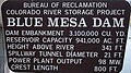
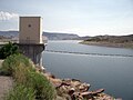
English: Blue Mesa Dam is a zoned earthfill dam on the Gunnison River in Colorado. It creates Blue Mesa Reservoir and is within Curecanti National Recreation Area just before the river enters the Black Canyon of the Gunnison. The dam is upstream of the Morrow Point Dam. Blue Mesa Dam and reservoir are part of the Bureau of Reclamation's Wayne N. Aspinall Unit of the Colorado River Storage Project, which retains the waters of the Colorado River and its tributaries for agricultural and municipal use in the American Southwest. The dam's primary purpose is hydroelectric power generation. Colorado State Highway 92 passes over the top of the dam. Blue Mesa Dam houses two turbine generators and produces an average of 264,329,000 kilowatt-hours each year.
Unterkategorien
Diese Kategorie enthält folgende Unterkategorie:
In Klammern die Anzahl der enthaltenen Kategorien (K), Seiten (S), Dateien (D)
B
- Blue Mesa Dam Overlook (3 D)
Medien in der Kategorie „Blue Mesa Dam“
Folgende 6 Dateien sind in dieser Kategorie, von 6 insgesamt.
-
 Blue Mesa Dam (1) (5932141131).jpg 4.454 × 3.977; 5,98 MB
-
 Blue Mesa Dam (2) (5932141979).jpg 6.330 × 5.223; 13,05 MB
-
 Blue Mesa Dam (2).JPG 1.666 × 930; 1,44 MB
-
 Blue Mesa Dam (3).JPG 2.048 × 1.536; 2,3 MB
-
 Blue Mesa Dam (7).JPG 2.048 × 1.536; 2,15 MB
-
 Bluemesadam.JPG 2.560 × 1.920; 1.013 KB
_(5932141131).jpg)
_(5932141979).jpg)
.JPG)
.JPG)
.JPG)