Category:Bor District
Zur Navigation springen
Zur Suche springen
|
English: Bor District is a district of Serbia with seat in Bor.
Hrvatski: Borski upravni okrug je okrug u Srbiji sa središtem u Boru.
Italiano: Il Distretto di Bor è un distretto della Serbia con sede a Bor.
Српски / srpski: Борски управни округ је округ у Србији са седиштем у Бору.
|
Distrikt in Serbien   | |||||
| Medium hochladen | |||||
| Ist ein(e) | |||||
|---|---|---|---|---|---|
| Ort |
| ||||
| Hauptstadt | |||||
| Datum der Gründung, Erstellung, Entstehung, Erbauung |
| ||||
| Einwohnerzahl |
| ||||
| Fläche |
| ||||
| Höhe über dem Meeresspiegel |
| ||||
| offizielle Website | |||||
 | |||||
Unterkategorien
Es werden 18 von insgesamt 18 Unterkategorien in dieser Kategorie angezeigt:
In Klammern die Anzahl der enthaltenen Kategorien (K), Seiten (S), Dateien (D)
B
- Bor train station (2 D)
- Bus stops in Bor District (1 D)
C
D
- Demographics of Bor District (1 D)
F
M
P
- Postcards of Bor District (2 D)
- Projekat Zaleđe Dunava i Đerdapa (5757 D)
R
T
- Tabula Traiana (55 D)
V
Medien in der Kategorie „Bor District“
Folgende 70 Dateien sind in dieser Kategorie, von 70 insgesamt.
-
 Bunar - panoramio.jpg 960 × 1.280; 297 KB
-
 Bunar Nikole Masanovica - panoramio.jpg 960 × 1.280; 259 KB
-
 Bycicle guidepost Bregovo 9,3 km.jpg 3.264 × 1.836; 2,73 MB
-
 Bycicle guidepost Bregovo 9,7 km.jpg 3.264 × 1.836; 2,48 MB
-
 Bycicle guidepost Rajac 0,8 km.jpg 3.264 × 1.836; 1,39 MB
-
 Bycicle guidepost Rajac 2,6 km.jpg 3.264 × 1.836; 2,73 MB
-
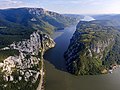 Cazanele Dunării.jpg 4.000 × 3.000; 4,19 MB
-
 Cycling guidepost staza za brdski biciklizam 7 km.jpg 3.264 × 1.836; 3,54 MB
-
 Damaged Guidepost in Vidrovac 2,2 km.jpg 2.048 × 1.536; 457 KB
-
 Detail of Hiking path information board in Sarkamen.jpg 2.048 × 1.536; 189 KB
-
 Entrance of Camp Timok near.jpg 3.264 × 1.836; 2,9 MB
-
 ETH-BIB-Hügellandschaft-Weitere-LBS MH02-25-0042.tif 4.895 × 3.307; 46,42 MB
-
 Guidepost Alija 4,07 km.jpg 3.264 × 1.836; 3,66 MB
-
 Guidepost Biger 1,41 km.jpg 3.264 × 1.836; 2,7 MB
-
 Guidepost Biger 2,11 km.jpg 3.264 × 1.836; 2,55 MB
-
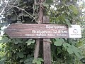 Guidepost in Vidrovac, Bratujevac 12,5 km.jpg 2.048 × 1.536; 373 KB
-
 Guidepost Prerast (Rajska) 0,45 km.jpg 3.264 × 1.836; 2,2 MB
-
 Guidepost Prerast (Rajska) 0,9 km.jpg 3.264 × 1.836; 3,09 MB
-
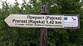 Guidepost Prerast (Rajska) 1,42 km.jpg 3.264 × 1.836; 3,22 MB
-
 Guidepost Prerast (Rajska) 1,9 km.jpg 3.264 × 1.836; 3,08 MB
-
 Guidepost Prerast u kanjonu Zamne 0,38 km.jpg 3.264 × 1.836; 1,97 MB
-
 Guidepost Prerast u kanjonu Zamne 0,52 km.jpg 3.264 × 1.836; 2,69 MB
-
 Guidepost Prerast u kanjonu Zamne 1,22 km.jpg 3.264 × 1.836; 2,44 MB
-
 Guidepost Prerast u kanjonu Zamne 1,52 km.jpg 3.264 × 1.836; 2,81 MB
-
 Guidepost Rogljevske pivnice 7,7 km.jpg 3.264 × 1.836; 3,95 MB
-
 Guidepost Suva kapija 0,15 km.jpg 3.264 × 1.836; 3,02 MB
-
 Guidepost Suva kapija 1,83 km.jpg 3.264 × 1.836; 3,44 MB
-
 Guidepost Suva kapija 2,03 km.jpg 3.264 × 1.836; 3,76 MB
-
 Guidepost Suva kapija 2,5 km.jpg 3.264 × 1.836; 1,85 MB
-
 Guidepost Suva kapija 3,2 km.jpg 3.264 × 1.836; 1,4 MB
-
 Guidepost to planinarski dom stol 2 km.jpg 3.264 × 1.836; 3,51 MB
-
 Guidepost to planinarski dom stol 3 km.jpg 3.264 × 1.836; 3,86 MB
-
 Guidepost Vidikovac 0,1 km.jpg 3.264 × 1.836; 3,81 MB
-
 Guidepost Vidikovac 0,21 km.jpg 3.264 × 1.836; 2,47 MB
-
 Guidepost Voda 10 min, near Malinik picnic site.jpg 3.264 × 1.836; 3,63 MB
-
 Guidepost Waterfall 0,24 km.jpg 3.264 × 1.836; 2,77 MB
-
 Guidepost Waterfall 0,94 km.jpg 3.264 × 1.836; 3,58 MB
-
 Guidepost Zlot 4 h.jpg 3.264 × 1.836; 3,05 MB
-
 Hiking path information board in Sarkamen.jpg 2.048 × 1.536; 377 KB
-
 Hiking path map board in Sarkamen.jpg 1.536 × 2.048; 191 KB
-
 Kamp - panoramio (2).jpg 1.600 × 1.200; 446 KB
-
 Kamp kućica u hladu - panoramio.jpg 1.600 × 1.200; 340 KB
-
 Kuća Mašanovića - panoramio.jpg 960 × 1.280; 217 KB
-
 Lime kilns near Luka, East-Serbia.jpg 3.264 × 1.836; 3,63 MB
-
 Memorial beside of mountain hut Stol.jpg 3.264 × 1.836; 3,6 MB
-
 Municipality of Kladovo, Serbia - panoramio.jpg 3.072 × 2.304; 1,94 MB
-
 Negde ispred Majdanpeka - panoramio.jpg 1.024 × 768; 313 KB
-
 Old Pharmacy in Negotin.jpg 3.264 × 1.836; 2,77 MB
-
 Panorama of mountain Veliki krs, 1148 m.jpg 4.892 × 1.642; 1,12 MB
-
 Picnic site between Tourist camp Mustecić and mountain Malinik.jpg 3.264 × 1.836; 4,98 MB
-
 Prerast - panoramio.jpg 1.944 × 2.592; 2,23 MB
-
 Radetova terasa - panoramio.jpg 960 × 1.280; 243 KB
-
 Rajska Prerast with river Zamna.jpg 1.836 × 3.264; 2,1 MB
-
 Rajska Prerast with woman.jpg 3.264 × 1.836; 2,12 MB
-
 Rajska Prerast, entrance.jpg 3.264 × 1.836; 3,82 MB
-
 Rajska Prerast, portrait.jpg 1.836 × 3.264; 1,97 MB
-
 Rajska prerast.jpg 3.264 × 1.836; 2,3 MB
-
 Spomen dom na Stevanskim livadama (2022).jpg 3.264 × 1.836; 3,15 MB
-
 Spomen dom na Stevanskim livadama - informativna ploca (2022).jpg 3.264 × 1.836; 2,94 MB
-
 Staudamm Eisernes Tor II bei Prahovo, flussaufwärts.jpg 2.048 × 1.536; 190 KB
-
 Stene - panoramio.jpg 3.072 × 2.304; 2,81 MB
-
 Tabla Petrovo Selo - panoramio.jpg 138 × 200; 7 KB
-
 Tačno vreme - panoramio.jpg 3.648 × 2.736; 4,94 MB
-
 Tihova kuca - panoramio.jpg 960 × 1.280; 238 KB
-
 View from mountain Stol in the direction of Bor.jpg 1.264 × 704; 341 KB
-
 View to the mountain Stol, 1155 m.jpg 3.264 × 1.836; 1,55 MB
-
 War memorial near Urovica.jpg 1.836 × 3.264; 2,44 MB
-
 Water well in Rajac.jpg 3.264 × 1.836; 4,45 MB
-
 Šipikovo, Serbia - panoramio (1).jpg 3.898 × 2.381; 2,66 MB
-
 Żelazne Wrota - panoramio (1).jpg 1.373 × 912; 394 KB


_0,45_km.jpg)
_0,9_km.jpg)
_1,42_km.jpg)
_1,9_km.jpg)


.jpg)


.jpg)
.jpg)


.jpg)
.jpg)