Category:Bradbourne
Vai alla navigazione
Vai alla ricerca

village and civil parish in Derbyshire Dales district, Derbyshire, England .jpg) | |||||
| Carica un file multimediale | |||||
| Istanza di | |||||
|---|---|---|---|---|---|
| Luogo | Derbyshire Dales, Derbyshire, Midlands Orientali, Inghilterra | ||||
| Considerato essere uguale a | Bradbourne (pagina Wikimedia duplicata, parrocchia civile dell'Inghilterra) | ||||
 | |||||
Sottocategorie
Questa categoria contiene le 3 sottocategorie indicate di seguito, su un totale di 3.
File nella categoria "Bradbourne"
Questa categoria contiene 79 file, indicati di seguito, su un totale di 79.
-
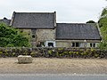
 A row of cottages in Bradbourne - geograph.org.uk - 4583960.jpg 800 × 533; 116 KB
-
 A weir below Lea Hall in the Bradbourne Brook - geograph.org.uk - 3823260.jpg 1 368 × 1 824; 640 KB
-
 Across the fields to Brassington - geograph.org.uk - 1349801.jpg 640 × 480; 66 KB
-
 Across Winn Brook from Brackendale Lane - geograph.org.uk - 4339903.jpg 4 000 × 3 000; 3,06 MB
-
 Approaching the turn off to Ballidon - geograph.org.uk - 997375.jpg 640 × 480; 64 KB
-
 B5056 and the turn for Parwich - geograph.org.uk - 2158484.jpg 900 × 675; 410 KB
-
 Brackendale Lane - geograph.org.uk - 4693214.jpg 3 072 × 1 728; 4,45 MB
-
 Brackendale Lane - geograph.org.uk - 4693215.jpg 3 072 × 1 728; 3,61 MB
-
 Brackendale Lane near Netherton Hall - geograph.org.uk - 4583946.jpg 800 × 533; 92 KB
-
 Brackendale Lane near Netherton Hall - geograph.org.uk - 5588693.jpg 4 988 × 3 728; 5,61 MB
-
 Bradbourne - a Thankful Village - geograph.org.uk - 4583959.jpg 533 × 800; 199 KB
-
 Bradbourne - geograph.org.uk - 2863017.jpg 640 × 425; 205 KB
-
 Bradbourne a Doubly Thankful village - geograph.org.uk - 6182519.jpg 2 000 × 1 330; 2,63 MB
-
 Bradbourne cottages - geograph.org.uk - 4583954.jpg 800 × 533; 154 KB
-
 Bradbourne Mill - geograph.org.uk - 1921816.jpg 640 × 480; 68 KB
-
 Bradbourne Mill 02.jpg 4 000 × 3 000; 4,85 MB
-
 Bradbourne Mill House.jpg 4 000 × 3 000; 1,88 MB
-
 Bradbourne Mill.jpg 4 000 × 3 000; 1,2 MB
-
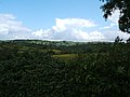
 Bradbourne Village from Haven Hill - geograph.org.uk - 4339577.jpg 4 000 × 3 000; 2,4 MB
-
 Capped Mine Shaft on Haven Hill - geograph.org.uk - 4339571.jpg 4 000 × 3 000; 3,51 MB
-
 Cattle at Sandhurst Farm - geograph.org.uk - 4339750.jpg 4 000 × 3 000; 2,2 MB
-

-
 Cattle posing in a buttercup field - geograph.org.uk - 1922082.jpg 640 × 480; 103 KB
-
 Concessionary path to Bank Top - geograph.org.uk - 4583952.jpg 800 × 533; 117 KB
-
 Converted barn at Netherton Hall - geograph.org.uk - 4580348.jpg 800 × 533; 107 KB
-
 Countryside off Brackendale Lane - geograph.org.uk - 273019.jpg 640 × 473; 112 KB
-
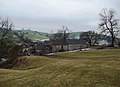
 Crowtrees Farm - geograph.org.uk - 1920389.jpg 640 × 480; 70 KB
-
 Crowtrees farm in spring - geograph.org.uk - 2342634.jpg 3 648 × 2 736; 4,05 MB
-
 Crowtrees Farm.jpg 3 862 × 2 804; 2,9 MB
-
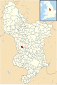 Derbyshire UK parish map highlighting Bradbourne.svg 888 × 1 308; 2,34 MB
-
 Derelict barn near Bradbourne - geograph.org.uk - 4583949.jpg 800 × 533; 107 KB
-
 Diamond Jubilee (Victoria) Memorial - geograph.org.uk - 2992571.jpg 3 264 × 2 448; 2,03 MB
-
 Diamond Jubilee Monument, Bradbourne - geograph.org.uk - 4684508.jpg 3 072 × 1 728; 4,3 MB
-
 Dilapidated barn near Bradbourne - geograph.org.uk - 4693216.jpg 3 072 × 1 728; 3,33 MB
-
 Edge of Access Land on Haven Hill - geograph.org.uk - 4339557.jpg 4 000 × 3 000; 2,84 MB
-

-
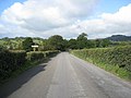
 Fields and road - geograph.org.uk - 2835639.jpg 640 × 426; 73 KB
-
 Gates on a bridleway, near Bradbourne - geograph.org.uk - 1921797.jpg 640 × 480; 113 KB
-
 Havenhill Dale - geograph.org.uk - 4339582.jpg 4 000 × 3 000; 3,3 MB
-
 Havenhill Dale Brook - geograph.org.uk - 2009516.jpg 4 000 × 3 000; 2,39 MB
-
 Hedgerow in full blossom - geograph.org.uk - 1920400.jpg 480 × 640; 132 KB
-
 Hipley Hill - geograph.org.uk - 4520877.jpg 3 769 × 4 891; 5,61 MB
-
 Looking down Wigber Low - geograph.org.uk - 4693222.jpg 3 072 × 1 728; 3,08 MB
-
 Netherton Hall - geograph.org.uk - 1349804.jpg 640 × 480; 52 KB
-
 Netherton Hall near Bradbourne - geograph.org.uk - 272462.jpg 640 × 480; 123 KB
-
 Netherton Hall.jpg 3 456 × 2 304; 977 KB
-
 On the path to Dulands Farm - geograph.org.uk - 4520875.jpg 4 958 × 3 722; 5,8 MB
-
 Ordnance Survey Cut Mark - geograph.org.uk - 2992555.jpg 3 264 × 2 448; 2,4 MB
-
 Ordnance Survey Cut Mark - geograph.org.uk - 2992573.jpg 3 264 × 2 448; 2,94 MB
-
 Outbuildings south of Bradbourne Mill.jpg 4 000 × 3 000; 4,55 MB
-
 Park Farm nr Bradbourne 01.jpg 3 456 × 2 304; 4,58 MB
-
 Park Farm nr Bradbourne 02.jpg 3 456 × 2 304; 4,98 MB
-
 Pedigree of the family of Buckston of Bradbourne.jpg 560 × 850; 126 KB
-
 Post box and hydrant by Netherton Hall - geograph.org.uk - 4693212.jpg 3 044 × 1 676; 3,96 MB
-

-
 Ruined farm building west of The Beeches - geograph.org.uk - 5588689.jpg 4 763 × 3 554; 3,5 MB
-
 Sandhurst Farm - geograph.org.uk - 1920284.jpg 640 × 480; 52 KB
-
-
 Steps to Netherton Hall - geograph.org.uk - 4583943.jpg 533 × 800; 137 KB
-
 The Bradbourne Brook flowing close by the B5056 - geograph.org.uk - 3823248.jpg 1 824 × 1 368; 1,13 MB
-
 The corner of a field - geograph.org.uk - 1922090.jpg 640 × 480; 133 KB
-
 The Old Parsonage, Bradbourne.jpg 3 456 × 2 304; 4,64 MB
-
 Track near Sandhurst Farm - geograph.org.uk - 4339767.jpg 4 000 × 3 000; 2,53 MB
-
 Track to New House Farm - geograph.org.uk - 4693220.jpg 3 072 × 1 728; 2,92 MB
-
 Track up Haven Hill (112355 c275629c-by-Ralph-Mills).jpg 529 × 437; 306 KB
-
 Track up Haven Hill - geograph.org.uk - 112355.jpg 600 × 498; 70 KB
-
 Two farms off Brackendale Lane. - geograph.org.uk - 1920393.jpg 640 × 480; 76 KB
-
 Upland Grazing near Bradbourne - geograph.org.uk - 4339825.jpg 4 000 × 3 000; 2,78 MB
-
 View across Bradbourne Brook - geograph.org.uk - 4173409.jpg 4 000 × 3 000; 2,23 MB
-
 View East from Haven Hill - geograph.org.uk - 4339552.jpg 4 000 × 3 000; 2,5 MB
-
 View to houses by Brackendale Lane, Bradbourne - geograph.org.uk - 5588691.jpg 5 179 × 3 885; 4,57 MB
-

-
 Winn Brook from Brackendale Lane - geograph.org.uk - 321562.jpg 640 × 480; 101 KB
-
 Winn Brook Valley - geograph.org.uk - 4583703.jpg 800 × 533; 104 KB
-
 Fields west of Tissington Ford - geograph.org.uk - 91391.jpg 640 × 427; 53 KB
-
 Near Parwich. - geograph.org.uk - 165960.jpg 640 × 480; 125 KB
-
 Near Parwich. - geograph.org.uk - 165964.jpg 640 × 480; 59 KB
-

-
 Wigber Low - geograph.org.uk - 112347.jpg 600 × 388; 74 KB


_Memorial_-_geograph.org.uk_-_2992571.jpg)


