Category:Bradstone
Aller à la navigation
Aller à la recherche
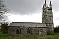
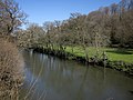
English: Bradstone is a village in Devon, England, on the River Tamar. It has a small church and a Tudor hall (now a farm) with an attractive gatehouse.
village britannique  | |||||
| Téléverser des médias | |||||
| Nature de l’élément | |||||
|---|---|---|---|---|---|
| Lieu | West Devon, Devon, Angleterre du Sud-Ouest, Angleterre | ||||
| Baigné par | |||||
| Population |
| ||||
 | |||||
Sous-catégories
Cette catégorie comprend 3 sous-catégories, dont les 3 ci-dessous.
Média dans la catégorie « Bradstone »
Cette catégorie comprend 34 fichiers, dont les 34 ci-dessous.
-
 Bawcombe Cottage - geograph.org.uk - 422141.jpg 640 × 480 ; 94 kio
-
 Bradstone Coombe - geograph.org.uk - 422150.jpg 480 × 640 ; 119 kio
-
 Bradstone Manor Farm - geograph.org.uk - 5758795.jpg 7 360 × 4 912 ; 7,24 Mio
-
 Bradstone, Doorway to the tower - geograph.org.uk - 5758787.jpg 5 324 × 3 554 ; 6,21 Mio
-
 Bradstone, St Nonna's Church - geograph.org.uk - 5723238.jpg 971 × 1 024 ; 410 kio
-
 Bradstone, St. Nonna's Church, a welcome from the 'church cat' 1 - geograph.org.uk - 5758766.jpg 5 788 × 3 863 ; 3,85 Mio
-
 Bradstone, St. Nonna's Church, a welcome from the 'church cat' 2 - geograph.org.uk - 5758770.jpg 4 971 × 3 317 ; 4,19 Mio
-
 Bradstone, St. Nonna's Church, C13th octagonal font with round bowl - geograph.org.uk - 5740173.jpg 4 912 × 7 360 ; 7,34 Mio
-
 Bradstone, St. Nonna's Church, Circa c15th waggon roof in nave - geograph.org.uk - 5740165.jpg 7 016 × 4 681 ; 6,04 Mio
-
 Bradstone, St. Nonna's Church, Granite pier in four bay north aisle - geograph.org.uk - 5740160.jpg 6 890 × 4 599 ; 5,31 Mio
-
 Bradstone, St. Nonna's Church, northern aspect - geograph.org.uk - 5758790.jpg 5 249 × 3 504 ; 3,05 Mio
-

-
 Bradstone, St. Nonna's Church, South porch - geograph.org.uk - 5740147.jpg 5 211 × 3 478 ; 6,03 Mio
-
 Bradstone, St. Nonna's Church, South porch roof - geograph.org.uk - 5740149.jpg 7 360 × 4 912 ; 7,67 Mio
-
 Bradstone, St. Nonna's Church, The c12th nave - geograph.org.uk - 5740172.jpg 7 360 × 4 912 ; 6,31 Mio
-
 Bradstone, St. Nonna's Church, The c12th nave with c13th font - geograph.org.uk - 5740158.jpg 7 094 × 4 735 ; 5,78 Mio
-
 Bradstone, St. Nonna's Church, The tower with its unusual pinnacles - geograph.org.uk - 5758811.jpg 7 360 × 4 912 ; 3,98 Mio
-
 ClobberyArms.png 812 × 934 ; 137 kio
-
 Field entrance east of Felldownhead - geograph.org.uk - 4429940.jpg 1 920 × 2 421 ; 1,27 Mio
-
 Flood plain of the River Tamar - geograph.org.uk - 1854333.jpg 640 × 480 ; 84 kio
-
 Greystone Bridge - geograph.org.uk - 4642547.jpg 1 600 × 1 361 ; 1,85 Mio
-
 Greystone Bridge Tollhouse, Dunterton - geograph.org.uk - 6114511.jpg 640 × 384 ; 156 kio
-
 Holland - geograph.org.uk - 422161.jpg 640 × 480 ; 84 kio
-
 House by Greystone Bridge - geograph.org.uk - 4642545.jpg 1 600 × 1 200 ; 1,59 Mio
-
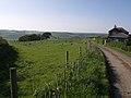
 Lane from Kelly to Bradstone - geograph.org.uk - 422134.jpg 640 × 480 ; 139 kio
-
 Meadow near Kelly - geograph.org.uk - 427426.jpg 640 × 480 ; 134 kio
-

-
 River Tamar at Greystone Bridge - geograph.org.uk - 4433875.jpg 1 920 × 1 440 ; 908 kio
-
 River Tamar at Greystone Bridge - geograph.org.uk - 4433904.jpg 1 920 × 1 385 ; 665 kio
-
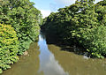 River Tamar at Greystone Bridge.jpg 3 900 × 2 749 ; 6,58 Mio
-
 The River Tamar below Greystone Bridge - geograph.org.uk - 1854351.jpg 640 × 480 ; 98 kio
-
 Traffic lights at Greystone Bridge - geograph.org.uk - 4429953.jpg 1 920 × 1 251 ; 714 kio
-
 Valley below Yeomans - geograph.org.uk - 458973.jpg 640 × 480 ; 113 kio
-
 Wood near Tredown - geograph.org.uk - 422170.jpg 640 × 480 ; 106 kio


.jpg)


