Category:Brawdy
Vai alla navigazione
Vai alla ricerca
Centro abitato del Galles   | |||||
| Carica un file multimediale | |||||
| Istanza di | |||||
|---|---|---|---|---|---|
| Luogo | Pembrokeshire, Galles | ||||
| Popolazione |
| ||||
| Superficie |
| ||||
 | |||||
Sottocategorie
Questa categoria contiene le 8 sottocategorie indicate di seguito, su un totale di 8.
B
- St David's Church, Brawdy (2 F)
- Brawdy quarry (1 F)
L
N
P
R
- RAF Brawdy (9 F)
T
- Treffynnon, Pembrokeshire (3 F)
File nella categoria "Brawdy"
Questa categoria contiene 200 file, indicati di seguito, su un totale di 268.
(pagina precedente) (pagina successiva)-
 2010 Wales Pembrokeshire Community Brawdy map.svg 512 × 393; 1 018 KB
-
 2024 Wales Pembrokeshire Community Brawdy map.svg 512 × 393; 1,19 MB
-
 A carpet of snowdrops - geograph.org.uk - 1212360.jpg 640 × 480; 143 KB
-
 A deceptively steep cwm - geograph.org.uk - 1121750.jpg 480 × 640; 99 KB
-
 A home for swallows - geograph.org.uk - 5397686.jpg 1 600 × 1 200; 337 KB
-
 A Lane Near Hayscastle - geograph.org.uk - 4992191.jpg 1 600 × 1 191; 293 KB
-
 A Lane Near Llandeloy - geograph.org.uk - 4992242.jpg 1 600 × 1 250; 175 KB
-
 A pair of Alpacas at Ty Parke - geograph.org.uk - 6257846.jpg 640 × 480; 61 KB
-
 A Steep Little Valley on the Coastal Slope - geograph.org.uk - 3671679.jpg 1 024 × 768; 334 KB
-
 A stretch of coast path - geograph.org.uk - 1545298.jpg 640 × 480; 245 KB
-
 A487 at Penycwm - geograph.org.uk - 3272933.jpg 640 × 480; 38 KB
-
 A487 between Newgale and Penycwm - geograph.org.uk - 2721907.jpg 640 × 480; 54 KB
-
 A487 west of Newgale Farm - geograph.org.uk - 3272927.jpg 640 × 479; 38 KB
-
 A487 west of Penycwm - geograph.org.uk - 3272942.jpg 640 × 480; 32 KB
-
 Above Cwm Bach - geograph.org.uk - 3160298.jpg 640 × 480; 101 KB
-
 Across Porthmynawyd - geograph.org.uk - 5167573.jpg 4 000 × 3 000; 2,34 MB
-
 Approaching Lochturffin Cross - geograph.org.uk - 2126011.jpg 640 × 480; 95 KB
-

-
 B Road - geograph.org.uk - 4829353.jpg 3 066 × 2 310; 762 KB
-
 Bank above Cwm Bach - geograph.org.uk - 5403112.jpg 3 264 × 2 448; 3,73 MB
-
 Barley field ready for harvest at Llanreithan - geograph.org.uk - 3661783.jpg 4 270 × 2 847; 3,59 MB
-
 Barns at Silver Hill - geograph.org.uk - 3701203.jpg 4 592 × 3 056; 4,81 MB
-
 Bay below Cwm Mawr - geograph.org.uk - 5167536.jpg 4 000 × 3 000; 2,26 MB
-
 Bend in the road near Bryngwyn - geograph.org.uk - 3680973.jpg 640 × 480; 64 KB
-
 Billowing clouds above Penycwm, Pembrokeshire - geograph.org.uk - 5397697.jpg 1 600 × 1 200; 227 KB
-
 Bramble Farm - geograph.org.uk - 3804940.jpg 640 × 480; 89 KB
-
 Brandy Brook - geograph.org.uk - 4749833.jpg 5 472 × 3 648; 7,66 MB
-
 Brandy Brook Ford - geograph.org.uk - 6132572.jpg 3 000 × 2 000; 6,25 MB
-
 Brandy Brook runs through shingle bank - geograph.org.uk - 5398382.jpg 1 600 × 1 200; 478 KB
-
 Brawdy airfield - geograph.org.uk - 5982239.jpg 3 264 × 2 448; 2,13 MB
-
 Brawdy Airfield, Brawdy, Pembrokeshire - geograph.org.uk - 477566.jpg 640 × 480; 118 KB
-
 Brawdy Business Park - geograph.org.uk - 4966342.jpg 3 264 × 2 448; 2,89 MB
-
 Brawdy Farm and farmyard - geograph.org.uk - 3701269.jpg 4 314 × 2 876; 3,06 MB
-
 Brawdy Farm.jpg 640 × 480; 82 KB
-
 Bridge over Stream - geograph.org.uk - 5403138.jpg 3 264 × 2 448; 3,85 MB
-
 Bus shelter at Trefgarn Owen - geograph.org.uk - 1982653.jpg 640 × 480; 99 KB
-
 Byway from Lochmeyler - geograph.org.uk - 1700660.jpg 640 × 480; 244 KB
-
 Caermedris, a farm near Solva, Pembrokeshire - geograph.org.uk - 5397676.jpg 1 600 × 1 200; 428 KB
-
 Cattle grazing near Pen-y-gors - geograph.org.uk - 3701301.jpg 4 401 × 2 934; 3,15 MB
-
 Cave on Newgale beach - geograph.org.uk - 3147304.jpg 4 592 × 3 056; 4,44 MB
-
 Cemetery At Treffgarne Owen - geograph.org.uk - 4600897.jpg 1 600 × 1 067; 242 KB
-
 Chapel At Treffgarne Owen - geograph.org.uk - 4600895.jpg 1 600 × 1 045; 250 KB
-
 Cliff Strata - geograph.org.uk - 2282126.jpg 1 000 × 665; 204 KB
-
 Cliff Strata - geograph.org.uk - 2282128.jpg 1 000 × 665; 224 KB
-
 Cliffs near Lochvane - geograph.org.uk - 5689314.jpg 4 592 × 3 056; 5,42 MB
-
 Clifftop and Coast Path - geograph.org.uk - 3671700.jpg 1 024 × 768; 319 KB
-
 Climbing wall - geograph.org.uk - 5983320.jpg 3 264 × 2 448; 1,92 MB
-
 Coast view with natural arch - geograph.org.uk - 5167553.jpg 3 000 × 4 000; 2,8 MB
-
 Coastal walk - steps a certainty - geograph.org.uk - 5167544.jpg 4 000 × 3 000; 2,29 MB
-
 Converted Chapel - geograph.org.uk - 4848174.jpg 5 472 × 3 648; 5,99 MB
-
 Cottage at Treffynnon - geograph.org.uk - 5826238.jpg 3 264 × 2 448; 2,97 MB
-
 Cottages at Penyfeidr - geograph.org.uk - 3665321.jpg 4 345 × 2 897; 3,49 MB
-
 Country lane near Treffynnon - geograph.org.uk - 3661822.jpg 4 592 × 3 056; 3,89 MB
-
 Country road and bend - geograph.org.uk - 2177945.jpg 640 × 480; 72 KB
-
 Cove at Cwm Bach - geograph.org.uk - 5404921.jpg 3 264 × 2 448; 3,99 MB
-
 Cows grazing above Crow Cwm - geograph.org.uk - 3691458.jpg 4 592 × 3 056; 4,08 MB
-
 Crossroad Near Llandeloy - geograph.org.uk - 4925679.jpg 1 600 × 1 064; 154 KB
-

-
 Cultivated Land - geograph.org.uk - 5405196.jpg 3 264 × 2 448; 3,15 MB
-
 Cwm Bach - geograph.org.uk - 3160288.jpg 640 × 480; 97 KB
-
 Cwm Bach - geograph.org.uk - 5404918.jpg 3 264 × 2 448; 2,73 MB
-
 Cwm Bach cove - geograph.org.uk - 1254150.jpg 640 × 480; 119 KB
-
 Cwm Mawr from the coastpath - geograph.org.uk - 5675220.jpg 4 592 × 3 056; 4,85 MB
-
 Dense Vegetation - geograph.org.uk - 5405163.jpg 2 448 × 3 264; 3,03 MB
-

-
 Dinas Fach - geograph.org.uk - 3158604.jpg 480 × 640; 106 KB
-
 Dinas Fach - geograph.org.uk - 3160276.jpg 640 × 480; 63 KB
-
 Dinas Fach - geograph.org.uk - 3671752.jpg 1 024 × 768; 311 KB
-
 Dinas Fach - geograph.org.uk - 5167578.jpg 3 841 × 2 881; 2 MB
-
 Dinas Fach - geograph.org.uk - 5405210.jpg 3 202 × 2 402; 2,18 MB
-
 Dinas Fach from the coast path - geograph.org.uk - 5688623.jpg 4 357 × 2 883; 4,16 MB
-
 Dinas Fach, late afternoon - geograph.org.uk - 5688990.jpg 4 592 × 3 056; 4,2 MB
-
 Driveway At Castle Villa - geograph.org.uk - 4829398.jpg 1 600 × 1 458; 634 KB
-
 Driveway to Castle Villa - geograph.org.uk - 5550437.jpg 3 264 × 2 448; 3,74 MB
-
 Entrance to Lochmeyler Farm - geograph.org.uk - 3665264.jpg 4 592 × 3 056; 4,7 MB
-
 Entrance to Parc Hall Caravan Park - geograph.org.uk - 3680962.jpg 640 × 480; 53 KB
-
 Extension to the graveyard of Brawdy church - geograph.org.uk - 3701255.jpg 4 592 × 3 056; 5,44 MB
-
 Farm At Lower Tancredston - geograph.org.uk - 4600910.jpg 1 600 × 1 066; 464 KB
-
 Farm at Pointz Castle - geograph.org.uk - 2599521.jpg 640 × 480; 105 KB
-
 Farmhouse, Lochvane, Pembrokeshire - geograph.org.uk - 5397664.jpg 1 600 × 1 200; 419 KB
-
 Farmland At Llethr, near Newgale - geograph.org.uk - 4588345.jpg 1 600 × 875; 398 KB
-
 Farmland near Penycwm youth hostel - geograph.org.uk - 3701298.jpg 4 592 × 3 056; 3,89 MB
-
 Farmyard at Clawdd-cam - geograph.org.uk - 3661765.jpg 4 592 × 3 056; 4,18 MB
-
 Farmyard at Silver Hill - geograph.org.uk - 3701014.jpg 4 592 × 3 056; 6,63 MB
-
 Farmyard at Treyscaw - geograph.org.uk - 3683573.jpg 4 592 × 3 056; 5,3 MB
-
 Farmyard, Lochmeyler Farm - geograph.org.uk - 3665284.jpg 4 592 × 3 056; 3,11 MB
-
 Farmyard, Troed-y-rhiw - geograph.org.uk - 3703732.jpg 4 464 × 2 976; 2,82 MB
-
 Field barns near Llandeloy - geograph.org.uk - 3665437.jpg 4 592 × 3 056; 4,95 MB
-
 Field entrance - geograph.org.uk - 6162732.jpg 1 024 × 768; 234 KB
-
 Field entrance near Llandeloy - geograph.org.uk - 2179953.jpg 640 × 480; 51 KB
-
 Field gateways - geograph.org.uk - 6162722.jpg 1 024 × 768; 245 KB
-
 Fields above Cwm Bach - geograph.org.uk - 3160339.jpg 640 × 480; 90 KB
-
 Footbridge and Ford - geograph.org.uk - 5397643.jpg 1 600 × 1 200; 721 KB
-
 Footbridge over Stream - geograph.org.uk - 5403125.jpg 2 448 × 3 264; 3,18 MB
-
 Footbridge over the stream above Porthmynawyd - geograph.org.uk - 5689355.jpg 4 592 × 3 056; 5,81 MB
-
 Ford across Brandy Brook - geograph.org.uk - 3687210.jpg 4 592 × 3 056; 4,28 MB
-

-
 Gate on Wales Coast Path - geograph.org.uk - 5405156.jpg 2 448 × 3 264; 3,12 MB
-
 Gateway To Hollybush - geograph.org.uk - 4829217.jpg 1 600 × 1 212; 283 KB
-
 George V postbox, Llandeloy - geograph.org.uk - 1982627.jpg 480 × 640; 30 KB
-
 Ger - Near Ogof Felen - geograph.org.uk - 4487257.jpg 640 × 415; 50 KB
-
 Glanafon Farm, Llandeloy - geograph.org.uk - 5646143.jpg 4 592 × 3 056; 3,63 MB
-
 Gnarled trees - geograph.org.uk - 5595229.jpg 3 264 × 2 448; 3,62 MB
-
 Harvesting wheat at Brawdy - geograph.org.uk - 3701222.jpg 4 592 × 3 056; 5,38 MB
-
 Haylage bales on Brawdy Airfield - geograph.org.uk - 3686809.jpg 4 426 × 2 951; 2,49 MB
-
 Hendre House - geograph.org.uk - 5982134.jpg 3 264 × 2 448; 3,05 MB
-
 Hollybush Farm - geograph.org.uk - 5825754.jpg 3 264 × 2 448; 2,85 MB
-
 Hollybush Farm - geograph.org.uk - 5825974.jpg 3 264 × 2 448; 1,84 MB
-
 House opposite the chapel at Blaen-llyn - geograph.org.uk - 3661751.jpg 4 390 × 2 927; 3,28 MB
-
 House under construction near Trenichol - geograph.org.uk - 3661839.jpg 4 460 × 2 974; 3,42 MB
-
 Houses at Lower Vanley - geograph.org.uk - 3665296.jpg 4 032 × 2 688; 2,32 MB
-
 Houses at Penycwm - geograph.org.uk - 5505280.jpg 4 592 × 3 056; 2,92 MB
-
 Houses in Llandeloy - geograph.org.uk - 4783091.jpg 1 024 × 768; 120 KB
-

-
 Junction with the B4330 - geograph.org.uk - 2183932.jpg 640 × 480; 48 KB
-
 Lake Overlooking Brandy Brook Near Rhoswingin - geograph.org.uk - 4588355.jpg 4 608 × 3 072; 2,43 MB
-
 Lane descending into the valley of Brandy Brook - geograph.org.uk - 3687128.jpg 4 592 × 3 056; 6,42 MB
-
 Lane From Tancredston - geograph.org.uk - 4927325.jpg 2 365 × 3 072; 888 KB
-
 Lane near Tancredston - geograph.org.uk - 392645.jpg 640 × 480; 90 KB
-
 Lane To Llanreithan Mill - geograph.org.uk - 4829225.jpg 1 602 × 2 010; 427 KB
-
 Lane To Tancredston - geograph.org.uk - 4600901.jpg 1 600 × 1 008; 304 KB
-
 Llandeloy - geograph.org.uk - 5826248.jpg 3 264 × 2 448; 2,61 MB
-
 Llandeloy Village - geograph.org.uk - 4925647.jpg 1 600 × 1 118; 217 KB
-
 Llanreithan Farm - geograph.org.uk - 5825979.jpg 3 264 × 2 448; 1,89 MB
-
 Lochmeyler snowdrops - geograph.org.uk - 1700676.jpg 640 × 480; 295 KB
-
 Looking out to Sea from Cwm Mawr - geograph.org.uk - 3671661.jpg 1 024 × 768; 292 KB
-
 Looking towards Cwm Mawr from Pwll March - geograph.org.uk - 5505072.jpg 4 592 × 3 056; 3,75 MB
-
 Lower Eweston Farm - geograph.org.uk - 3691439.jpg 4 592 × 3 056; 5,72 MB
-
 Lower Vanley - geograph.org.uk - 4925637.jpg 1 600 × 1 011; 120 KB
-
 Lower Vanley Farm - geograph.org.uk - 5826247.jpg 3 264 × 2 448; 3,3 MB
-
 Minor road junction near Llanddinog - geograph.org.uk - 3680977.jpg 640 × 480; 89 KB
-
 Minor road junction near Treffynnon - geograph.org.uk - 2178536.jpg 640 × 480; 53 KB
-

-
 Minor road near Trenichol - geograph.org.uk - 2234719.jpg 640 × 480; 109 KB
-

-
 Natural arch and coastal collapse - geograph.org.uk - 1545296.jpg 640 × 480; 268 KB
-
 New Inn Cottage - geograph.org.uk - 2985148.jpg 4 288 × 3 216; 3,48 MB
-
 Newgale - geograph.org.uk - 22008.jpg 640 × 417; 56 KB
-
 Newgale Bay - geograph.org.uk - 5400492.jpg 3 264 × 2 448; 2,08 MB
-
 Newgale Farm - geograph.org.uk - 5657516.jpg 4 592 × 3 056; 4,27 MB
-
 Newgale from lay-by on Roch Road - geograph.org.uk - 4507491.jpg 1 600 × 1 200; 193 KB
-
 Newgale Hill towards Newgale, Pembrokeshire - geograph.org.uk - 4317289.jpg 1 600 × 1 062; 270 KB
-
 Newgale Hill towards Newgale, Pembrokeshire - geograph.org.uk - 4317293.jpg 1 600 × 1 062; 366 KB
-
 Newgale in Summer - geograph.org.uk - 2035587.jpg 1 024 × 768; 215 KB
-
 Newgale Sands - geograph.org.uk - 2282130.jpg 1 000 × 665; 216 KB
-
 Newgale Sands - geograph.org.uk - 2599504.jpg 640 × 480; 130 KB
-
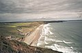
 Newgale Sands - geograph.org.uk - 3160315.jpg 640 × 480; 79 KB
-
 Newgale village - geograph.org.uk - 3160324.jpg 480 × 640; 102 KB
-
 Newgale, A487 and islands view - geograph.org.uk - 2028655.jpg 640 × 480; 80 KB
-
 Newgale, view over Newgale Sands - geograph.org.uk - 2028659.jpg 640 × 480; 62 KB
-
 Old farm at Lochvane - geograph.org.uk - 2396553.jpg 640 × 480; 79 KB
-
 On the clifftop - geograph.org.uk - 3671643.jpg 1 024 × 768; 316 KB
-
 Ordnance Survey Cut Mark - geograph.org.uk - 5557021.jpg 640 × 349; 101 KB
-
 Ordnance Survey Cut Mark - geograph.org.uk - 5557024.jpg 640 × 410; 121 KB
-
 Ordnance Survey Cut Mark - geograph.org.uk - 5557029.jpg 640 × 466; 140 KB
-
 Ordnance Survey Cut Mark - geograph.org.uk - 6061639.jpg 1 024 × 637; 294 KB
-
 Ordnance Survey Cut Mark - geograph.org.uk - 6061645.jpg 1 024 × 718; 213 KB
-
 Ordnance Survey Flush Bracket (11510) - geograph.org.uk - 5557019.jpg 459 × 640; 116 KB
-
 Ordnance Survey Flush Bracket 11510 - geograph.org.uk - 3481879.jpg 4 000 × 3 000; 4,34 MB
-
 Ordnance Survey Flush Bracket 11511 - geograph.org.uk - 3481902.jpg 4 000 × 3 000; 4,49 MB
-
 Overgrown hedge - geograph.org.uk - 5595231.jpg 3 264 × 2 448; 3,2 MB
-
 Parc Hall Caravan Site - geograph.org.uk - 4966620.jpg 3 264 × 2 448; 1,58 MB
-
 Part of Aber West and Dinas Fawr - geograph.org.uk - 2397227.jpg 640 × 480; 69 KB
-

-
 Passing place, near Llandeloy - geograph.org.uk - 1982600.jpg 640 × 480; 72 KB
-
 Path Near Dolgwm - geograph.org.uk - 4588374.jpg 1 600 × 1 067; 398 KB
-
 Pembrokeshire Cliffs - geograph.org.uk - 3671733.jpg 1 024 × 768; 318 KB
-
 Pembrokeshire coast - geograph.org.uk - 3160280.jpg 640 × 480; 88 KB
-

-
 Pembrokeshire Coast Path above Cwm Bach - geograph.org.uk - 3160330.jpg 640 × 480; 121 KB
-
 Pembrokeshire Coast Path above Cwm Bach - geograph.org.uk - 5675241.jpg 4 592 × 3 056; 5,07 MB
-
 Pembrokeshire Coast Path above Cwm Bach - geograph.org.uk - 5675302.jpg 4 592 × 3 056; 4,31 MB
-
 Pembrokeshire Coast Path above Ogof y Felin - geograph.org.uk - 5688265.jpg 4 592 × 3 056; 4,69 MB
-
 Pen-y-Cwm - geograph.org.uk - 4848167.jpg 5 095 × 2 900; 5,99 MB
-

-
 Phone box, Penycwm - geograph.org.uk - 2582422.jpg 640 × 480; 81 KB
-
 Porthmynawyd - geograph.org.uk - 4487274.jpg 640 × 429; 65 KB
-
 Reflections at dusk on the road to Llandeloy - geograph.org.uk - 5982410.jpg 2 339 × 1 627; 1,15 MB
-
 Rickeston Hall - geograph.org.uk - 163341.jpg 640 × 480; 411 KB
-
 Rickeston Hall - geograph.org.uk - 4966625.jpg 3 264 × 2 448; 2,56 MB
-
 Road junction - geograph.org.uk - 5826234.jpg 3 264 × 2 448; 3,64 MB
-
 Road junction - geograph.org.uk - 5982135.jpg 3 264 × 2 448; 3,2 MB
-
 Road junction at sunset - geograph.org.uk - 5595234.jpg 3 264 × 2 448; 1,57 MB
-
 Road junction by Tancredston Bridge - geograph.org.uk - 2177910.jpg 640 × 480; 78 KB
-
 Road to Penycwm - geograph.org.uk - 2781762.jpg 640 × 480; 37 KB
-
 Rocky foreshore at Cwm Mawr - geograph.org.uk - 6051879.jpg 5 841 × 3 894; 4,79 MB
-
 Rough pasture near Upper Eweston - geograph.org.uk - 3691470.jpg 4 592 × 3 056; 3,81 MB
-
 Ruined Building - geograph.org.uk - 4966614.jpg 1 895 × 1 543; 389 KB
-
 Runway to the rainbow - geograph.org.uk - 1063040.jpg 640 × 480; 80 KB
-
 Rural crossroads near Llandeloy - geograph.org.uk - 1985010.jpg 640 × 480; 69 KB
-
 Sands Cafe, Newgale, Pembrokeshire - geograph.org.uk - 5398378.jpg 1 600 × 1 200; 348 KB
-
 Sea thrift at Cwm Mawr - geograph.org.uk - 5505068.jpg 4 592 × 3 056; 4,04 MB
-
 Sea Thrift on Clifftop - geograph.org.uk - 5404912.jpg 3 211 × 2 407; 2,37 MB
-
 Sharp bend on the B4330 - geograph.org.uk - 1983218.jpg 640 × 480; 113 KB
-
 Small Copper Butterfly Basking in the Sun - geograph.org.uk - 5404928.jpg 2 271 × 1 530; 1 MB
-
 Springtime country road - geograph.org.uk - 6162728.jpg 1 024 × 768; 309 KB
-
 St David's Church, Brawdy - geograph.org.uk - 5982236.jpg 3 264 × 2 448; 2,11 MB
-
 Steep Footpath - geograph.org.uk - 5403107.jpg 2 448 × 3 264; 2,55 MB
-
 Steps on the Pembrokeshire Coast Path above Cwm Bach - geograph.org.uk - 5675265.jpg 4 592 × 3 056; 5,17 MB
-
 Stile and fence on the cliff above Ogof Felen - geograph.org.uk - 5688268.jpg 4 592 × 3 056; 3,75 MB


_-_geograph.org.uk_-_5557019.jpg)


