Category:Bude, Cornwall
Vai alla navigazione
Vai alla ricerca
paese della Cornovaglia  | |||||
| Carica un file multimediale | |||||
| Istanza di | |||||
|---|---|---|---|---|---|
| Luogo | Bude-Stratton, Cornwall, Sud Ovest dell'Inghilterra, Inghilterra | ||||
| Distinto da | |||||
| sito web ufficiale | |||||
 | |||||
Brezhoneg: Ur gêr a g Kernev-Veur eo Porth Bud (LFE: [ˌpɔrθ 'by:t], Bude e saozneg) war an aod e pastell-vro Kernow Gledh, anezhi ul lodenn eus parrez keodedel Bud-Strasnedh.
Deutsch: Bude ist eine Ortschaft an der Nordküste der Grafschaft Cornwall nahe der Grenze zur Grafschaft Devon im Südwesten Englands. Der Ort ist rechts und links des Flusses Neet angesiedelt und hat sich dank der ausgedehnten Sandstrände beiderseits der Flussmündung in neuerer Zeit zu einem bevorzugten Ferienort entwickelt. Die Zersiedlung durch Ferienhäuser und Hotels hielt sich dabei jedoch in Grenzen.
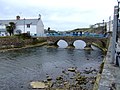
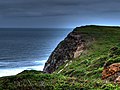
English: Bude is a small seaside resort town in North Cornwall, England, at the mouth of the River Neet. Bude is twinned with Ergué-Gabéric in Brittany, France. It is suggested that the modern name is a shortened form of Bude Haven and that this in turn was a corruption of the name Bede Haven meaning "Harbour of the holy men" suggesting Bude might have been a landing place for early Christians.
Italiano: Bude (in lingua cornica Bud) è un paese di 9.242 abitanti della Cornovaglia, in Inghilterra. Si trova nella parrocchia civile di Bude-Stratton.
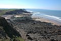
Kernowek: Porth Bud (yn sowsnek, Bude) yw port byghan yn Kernow, Breten Veur, war Vor Havren orth aber Avon Bud. Yma 4674 a drigoryon y'n dre. Yma'n dre menestrys warbarth gans Strasnedh, tre marghas 2 km dhe'n howldrevel, gans Konsel Tre Bud-Strasnedh. Klegerek yw an morrep dhe soth an dre. Tornyaseth yw an diwysyans chyf; pyskek hag esperthyans growdir o diwysyansow poesek seulabrys.
Nederlands: Bude ( Cornisch: Porth Bud) is een plaats in het Engelse graafschap Cornwall. De plaats telt 9242 inwoners.
Polski: Bude - ( korn. Bud) miasto w Wielkiej Brytanii, w Anglii w Kornwalii, położone przy ujściu rzeki Neet, nad Oceanem Atlantyckim na północno - wschodnim skraju hrabstwa, Dawniej port, od czasów wiktoriańskich popularna miejscowość wypoczynku letniego o znaczeniu ponadregionalnym. Przez miasto przebiega jedna z najbardziej malowniczych dróg Anglii, Atlantic Highway (A 39).
Română: Bude ( Limba cornică: Bud) este un oraş şi o staţiune turistică în comitatul Cornwall, regiunea South West, Anglia. Oraşul aparţine districtului North Cornwall.
Sottocategorie
Questa categoria contiene le 15 sottocategorie indicate di seguito, su un totale di 15.
B
- Bude Harbour, Cornwall (4 F)
- Bude Tunnel (1 F)
C
- Countryside around Bude (11 F)
- Crooklets Beach, Bude (17 F)
N
- River Neet (15 F)
S
- Streets in Bude, Cornwall (21 F)
- Summerleaze Beach, Bude (45 F)
T
- Tidal swimming pool, Bude (15 F)
W
File nella categoria "Bude, Cornwall"
Questa categoria contiene 95 file, indicati di seguito, su un totale di 95.
-

-
 Gezicht op de kust bij Bude, RP-F-F01135-BH (cropped).jpg 3 343 × 2 270; 1,12 MB
-
 Gezicht op de kust bij Bude on Trevelver met op de voorgrond een riviermond, RP-F-F01135-BH.jpg 3 221 × 2 062; 1 006 KB
-
 A rock with sea life on it - panoramio.jpg 2 402 × 3 208; 3,39 MB
-

-
 Beaches at Bude, Cornwall - panoramio.jpg 3 660 × 2 440; 7,3 MB
-
 Bencoolen Meadow Bude RFC.jpg 3 264 × 2 448; 1,69 MB
-

-
 Bude - panoramio (1).jpg 1 024 × 435; 342 KB
-
 Bude - panoramio.jpg 2 048 × 1 536; 778 KB
-
 Bude -and- Strattan, Cornwall, England-LCCN2002696584.jpg 3 720 × 2 800; 3,34 MB
-
 Bude aerial image (29299621263).jpg 2 152 × 1 409; 1,46 MB
-
 Bude Banner.jpg 3 600 × 514; 1,31 MB
-
 Bude Post Box.jpg 2 013 × 2 612; 1,61 MB
-
 Bude Sea Lock - Cornwall aerial image (29298924114).jpg 2 000 × 1 324; 1,03 MB
-
 Bude Sea Pool Big Lunch - 2017 (34595715413).jpg 5 760 × 3 840; 9,07 MB
-
 Bude Sea Pool Big Lunch - 2017 (34595722283).jpg 5 760 × 3 840; 9,38 MB
-
 Bude the coast looking N.E. Cornwall England.jpg 1 070 × 842; 170 KB
-
 Bude The Strand - panoramio.jpg 3 072 × 2 304; 1,21 MB
-
 Bude, path and tramway remains - geograph.org.uk - 1249302.jpg 480 × 640; 64 KB
-
 Bude, the coast looking N.E., Cornwall, England-LCCN2002696583.jpg 3 680 × 2 768; 3,04 MB
-
 Bude. - panoramio.jpg 3 648 × 2 736; 2,63 MB
-
 Burning Bude (207978699).jpeg 2 048 × 1 215; 323 KB
-
 Campbell-Stokes recorder in Bude, Cornwall.jpg 460 × 500; 52 KB
-
 Castle and church, Bude, Cornwall, England-LCCN2002696582.jpg 3 700 × 2 779; 2,93 MB
-
 Coast near Bude - panoramio.jpg 3 304 × 3 116; 4,16 MB
-
 Coastal Scene - geograph.org.uk - 253166.jpg 640 × 426; 28 KB
-
 Footprints in the sand - geograph.org.uk - 422602.jpg 426 × 640; 80 KB
-
 Harbour and Boatyard - geograph.org.uk - 123166.jpg 640 × 480; 109 KB
-
 Heavy sky at Sandymouth Bay, near Bude, Cornwall - geograph.org.uk - 4716859.jpg 4 000 × 3 000; 4,65 MB
-

-
 Just upstream of the mouth of the River Neet - geograph.org.uk - 5579700.jpg 1 795 × 1 346; 587 KB
-
 Klimadiagramm-metrisch-deutsch-Bude (England)-GB.png 1 024 × 713; 111 KB
-
 Llandaff shipwreck at Bude, RP-F-F01135-BT (cropped).jpg 1 488 × 1 202; 149 KB
-
 Maer Cliffs - panoramio - Jynto.jpg 2 379 × 3 248; 4,22 MB
-
 Maer Cliffs - panoramio.jpg 3 170 × 2 371; 2,68 MB
-
 MaerCliffNearBudeCornwallUK.jpg 640 × 426; 115 KB
-
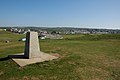 Monument in Bude - geograph.org.uk - 422190.jpg 640 × 426; 103 KB
-
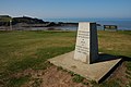 Monument in Bude - geograph.org.uk - 422200.jpg 640 × 426; 105 KB
-
 Mouth of the River Neet at low tide - geograph.org.uk - 5579702.jpg 2 122 × 1 591; 699 KB
-
 Mussels near Menachurch Point - geograph.org.uk - 411104.jpg 640 × 480; 356 KB
-
 Northcott Mouth - geograph.org.uk - 422481.jpg 640 × 426; 125 KB
-
 Ordnance Survey One-Inch Sheet 127 River Torridge & District, Published 1931.jpg 12 193 × 8 941; 11,98 MB
-
 Ordnance Survey One-Inch Sheet 174 Bude, Published 1946.jpg 8 185 × 9 539; 8,65 MB
-
 Ordnance Survey One-Inch Sheet 174 Bude, Published 1961.jpg 8 293 × 9 943; 8,61 MB
-
 Ordnance Survey One-Inch Sheet 174 Bude, Published 1971.jpg 11 094 × 13 190; 39,1 MB
-
 Overlooking Bude Bay (Ewe and Lambs at Rest).jpg 800 × 592; 84 KB
-
 Panorama of coast near Bude - panoramio.jpg 6 500 × 2 246; 4,91 MB
-
 Pink Thrift, Northcott Mouth - geograph.org.uk - 422479.jpg 640 × 426; 163 KB
-
 Post and Boat in Bude Harbour - panoramio.jpg 2 816 × 2 112; 2,44 MB
-
 Rocks at Compass Point near Bude, Cornwall - geograph.org.uk - 4719605.jpg 4 000 × 3 000; 4,17 MB
-
 Rocky beach - panoramio.jpg 3 234 × 2 356; 2,75 MB
-

-
 Rotsformatie aan de kust bij Bude, RP-F-F01135-BT.jpg 1 068 × 720; 143 KB
-
 Sand in the mist below Stowe Cliffs - geograph.org.uk - 404674.jpg 640 × 480; 34 KB
-
 Sculpture by the Bude Canal - geograph.org.uk - 1450944.jpg 640 × 480; 98 KB
-
 Signposts, Bude - geograph.org.uk - 1328653.jpg 640 × 480; 108 KB
-
 Sloping rock face, Maer Cliff - geograph.org.uk - 411049.jpg 640 × 480; 220 KB
-
 The 'Island Belle' off a Coastal Fort CI GMAG GMAG 2004 110.jpg 800 × 534; 79 KB
-
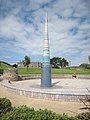 The Bude Light - geograph.org.uk - 1450835.jpg 480 × 640; 72 KB
-
 The Bude Light and Bude town - geograph.org.uk - 1036468.jpg 640 × 480; 75 KB
-
 The Bude Light and The Castle, Bude - geograph.org.uk - 1328528.jpg 640 × 480; 84 KB
-
 The coast at Bude - geograph.org.uk - 1549225.jpg 640 × 480; 90 KB
-
 The coast south of Efford Beacon - geograph.org.uk - 1549215.jpg 480 × 640; 86 KB
-
 Trash grid, Flexbury Park, Bude - geograph.org.uk - 1348815.jpg 640 × 480; 153 KB
-
 Trash grid, Flexbury, Bude - geograph.org.uk - 1345239.jpg 640 × 480; 167 KB
-
 View from the clifftop - panoramio.jpg 2 375 × 3 191; 3,17 MB
-
 View of Sandymouth - panoramio.jpg 3 206 × 2 424; 2,87 MB
-
 Warren Little Beach - geograph.org.uk - 422597.jpg 640 × 426; 104 KB
-
 Western Greyhound 557 on route 530 near Morwenstow (13385363385).jpg 2 880 × 1 623; 1,82 MB
-
 Whale's Back & Saddle Rock, Bude, Cornwall, RP-F-F01135-BT (cropped).jpg 1 126 × 848; 157 KB
-
 Wrak van de Llandaff voor de kust van Bude (vergaan 2 oktober 1899), RP-F-F01135-BS.jpg 2 634 × 2 021; 449 KB
-
 Amusement arcade at Crooklets Beach - geograph.org.uk - 1455750.jpg 640 × 427; 77 KB
-
 Bartlett Avenue - geograph.org.uk - 473645.jpg 640 × 426; 111 KB
-
 Bude - geograph.org.uk - 350282.jpg 640 × 480; 46 KB
-
 Canoeists off Bude rocks - geograph.org.uk - 776786.jpg 640 × 480; 50 KB
-
 Cliffs north of Maer Down - geograph.org.uk - 476607.jpg 640 × 423; 56 KB
-
 Coast road - geograph.org.uk - 253160.jpg 640 × 426; 54 KB
-
 Coast South of Bude - geograph.org.uk - 130838.jpg 640 × 424; 115 KB
-
 Coastline near Efford Down - geograph.org.uk - 563739.jpg 640 × 480; 137 KB
-
 Cottages at Northcott Mouth - geograph.org.uk - 422477.jpg 640 × 426; 111 KB
-
 Elements Surf Hotel, Bude - geograph.org.uk - 411199.jpg 640 × 480; 238 KB
-
 Footbridge over River Neet - geograph.org.uk - 428998.jpg 640 × 426; 130 KB
-
 Higher Longbeak - geograph.org.uk - 563725.jpg 640 × 480; 146 KB
-
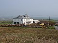
 House at Northcott Mouth - geograph.org.uk - 411070.jpg 640 × 480; 82 KB
-
 Joggers on coast path, Upton - geograph.org.uk - 411195.jpg 640 × 480; 226 KB
-
 King's Hill Meadow, Bude - geograph.org.uk - 218103.jpg 640 × 426; 130 KB
-
 Lower Northcott Farm lane - geograph.org.uk - 427346.jpg 640 × 426; 90 KB
-
 Maer Down and Cliff - geograph.org.uk - 410897.jpg 640 × 480; 210 KB
-
 Northcott House, Maer Cliff - geograph.org.uk - 411066.jpg 640 × 480; 177 KB
-
 Phillip's Point, beach and cliffs - geograph.org.uk - 411201.jpg 640 × 480; 248 KB
-
 Rock strata at Phillip's Point - geograph.org.uk - 563726.jpg 640 × 480; 140 KB
-
 Shipwreck remains at Menachurch Point - geograph.org.uk - 404689.jpg 480 × 640; 121 KB
-
 Thrift by Northcott Mouth - geograph.org.uk - 411073.jpg 640 × 480; 360 KB
-
 Wave-cut platform below Phillips Point - geograph.org.uk - 404703.jpg 480 × 640; 256 KB
_en_Bude_Castle_(midden),_RP-F-F01135-BG.jpg)
.jpg)


.jpg)


.jpg)

.jpg)
.jpg)
.jpg)


.jpeg)


-GB.png)
.jpg)


.jpg)


.jpg)
.jpg)
,_RP-F-F01135-BS.jpg)


