Category:Bundesautobahn 7
Naar navigatie springen
Naar zoeken springen

bondsautosnelweg in Duitsland .jpg)   | |||||
| Media uploaden | |||||
| Is een | |||||
|---|---|---|---|---|---|
| Locatie | |||||
| Transportnetwerk | |||||
| Sluit aan op | |||||
| Eigendom van | |||||
| Beheerder | |||||
| Lengte |
| ||||
| Niet gelijk aan | |||||
| |||||
Bundesautobahn by number: 1 - 2 - 3 - 4 - 5 - 6 - 7 - 8 - 9 - 10 - 11 - 12 - 13 - 14 - 15 - 17 - 19 - 20 - 21 - 22 - 23 - 24 - 25 - 26 - 27 - 28 - 29 - 30 - 31 - 33 - 36 - 37 - 38 - 39 - 40 - 42 - 43 - 44 - 45 - 46 - 48 - 49 - 52 - 56 - 57 - 59 - 60 - 61 - 62 - 63 - 64 - 65 - 66 - 67 - 70 - 71 - 72 - 73 - 81 - 83 - 85 - 86 - 89 - 91 - 92 - 93 - 94 - 95 - 96 - 98 - 99 - 100 - 103 - 104 - 105 - 111 - 113 - 114 - 115 - 117 - 143 - 210 - 215 - 226 - 250 - 252 - 253 - 255 - 261 - 270 - 280 - 281 - 293 - 352 - 369 - 391 - 392 - 395 - 442 - 445 - 448 - 480 - 485 - 516 - 524 - 535 - 540 - 542 - 544 - 552 - 553 - 555 - 559 - 560 - 562 - 565 - 571 - 573 - 602 - 620 - 623 - 643 - 648 - 650 - 656 - 659 - 661 - 671 - 672 - 831 - 860 - 861 - 862 - 864 - 952 - 980 - 995 - 999
Ondercategorieën
Deze categorie bevat de volgende 9 subcategorieën, van de 9 in totaal.
Pagina’s in categorie "Bundesautobahn 7"
Deze categorie bevat alleen de volgende pagina.
Media in categorie "Bundesautobahn 7"
Deze categorie bevat de volgende 92 bestanden, van in totaal 92.
-
 A 7 bei Hann-Münden 01.jpg 3.648 × 2.736; 1,67 MB
-
 A7 (E45) bei Dorfmark - geo.hlipp.de - 6873.jpg 640 × 470; 55 kB
-
 A7 - Bispingen Kreuze 43, 1000 m - geo.hlipp.de - 4031.jpg 640 × 390; 38 kB
-
 A7 - Egestorf Kreuze 41, 1000 m - geo.hlipp.de - 4030.jpg 640 × 379; 42 kB
-
 A7 - Garlstorf - Salzhausen - Nindorf - geo.hlipp.de - 4814.jpg 640 × 438; 31 kB
-
 A7 - Kreuz (40) - Garlstorf 900m - geo.hlipp.de - 6923.jpg 640 × 377; 41 kB
-
 A7 - Kreuz (42) - Evendorf - Amelinghausen - geo.hlipp.de - 6920.jpg 640 × 421; 43 kB
-
 A7 - Kreuz (42) - Evendorf 1000m - geo.hlipp.de - 6893.jpg 640 × 343; 40 kB
-
 A7 - Kreuz (48) - Dreieck Walsrode 2000m - geo.hlipp.de - 6674.jpg 640 × 448; 55 kB
-
 A7 - Kreuz (49) - Westenholz - geo.hlipp.de - 6624.jpg 640 × 446; 49 kB
-
 A7 - Kreuz (51) Berkhorf, 1000m - geo.hlipp.de - 6619.jpg 640 × 480; 43 kB
-
 A7 - Kreuz (52) Mellendorf, 1100m - geo.hlipp.de - 6618.jpg 640 × 442; 51 kB
-
 A7 - Kreuz 38 Seevetal-Ramelsloh (500m) - geo.hlipp.de - 14270.jpg 640 × 403; 34 kB
-
 A7 - Kreuz 40 - Garlstorf 500m - geo.hlipp.de - 6924.jpg 640 × 370; 36 kB
-
 A7 - Kreuz 41 - Egestorf (500m) - geo.hlipp.de - 14296.jpg 640 × 450; 42 kB
-
 A7 - Kreuz 41 Egestorf (1000m) - geo.hlipp.de - 14285.jpg 640 × 435; 41 kB
-
 A7 - Kreuz 43 - Bispingen (380m) - geo.hlipp.de - 14306.jpg 640 × 405; 40 kB
-
 A7 - Kreuz 43 - Bispingen (650m) - geo.hlipp.de - 14305.jpg 640 × 446; 42 kB
-
 A7 - Kreuz 48, Dreieck Walsrode (2000m) - geo.hlipp.de - 20766.jpg 640 × 394; 38 kB
-
 A7 - Kreuz 48, Walsrode (500m) - geo.hlipp.de - 20767.jpg 640 × 426; 44 kB
-
 A7 - Kreuz 49, Westenholz (1200m) - geo.hlipp.de - 16182.jpg 640 × 433; 45 kB
-
 A7 - Kreuz 50, Schwarmstedt (1000m) - geo.hlipp.de - 16011.jpg 640 × 431; 40 kB
-
 A7 - Kreuz 50, Schwarmstedt (500m) - geo.hlipp.de - 16012.jpg 640 × 419; 39 kB
-
 A7 - Kreuze 39 - Thieshope - 500 m - geo.hlipp.de - 6964.jpg 640 × 437; 44 kB
-
 A7 - Rasthof Brunautal, (1000m) - geo.hlipp.de - 14297.jpg 640 × 409; 37 kB
-
 A7 - Rastplatz zwischen Kreuz 44 und Kreuz 43 - geo.hlipp.de - 14307.jpg 640 × 480; 108 kB
-
 A7 - Rastplatz zwischen Kreuz 44 und Kreuz 43 - geo.hlipp.de - 14309.jpg 640 × 480; 111 kB
-
 A7 - Seevetal Rasthof 3km - geo.hlipp.de - 6967.jpg 640 × 451; 44 kB
-
 A7 - Thieshope Kreuze 39, 1000 m - geo.hlipp.de - 4029.jpg 640 × 373; 37 kB
-
 A7 - Wolfsgrund Rastplatz (500m) - geo.hlipp.de - 14005.jpg 640 × 446; 50 kB
-
 A7 bei Brokenlande 01.jpg 2.160 × 3.840; 1,95 MB
-
 A7 bei Brokenlande 02.jpg 2.160 × 3.840; 2,06 MB
-
 A7 bei Brokenlande 03.jpg 2.160 × 3.840; 1,33 MB
-
 A7 bei Ehndorf.jpg 2.448 × 3.264; 909 kB
-
 A7 bei Kreuz 44 - Soltau-Ost - geo.hlipp.de - 6875.jpg 640 × 412; 37 kB
-
 A7 bei Kreuz Garlstorf - geo.hlipp.de - 6925.jpg 640 × 362; 39 kB
-
 A7 bei Parkplatz Seevetal - geo.hlipp.de - 14271.jpg 640 × 391; 39 kB
-
 A7 bei Rasthof Allertal - geo.hlipp.de - 6622.jpg 640 × 392; 41 kB
-
 A7 bei Soltau - geo.hlipp.de - 6872.jpg 640 × 441; 45 kB
-
 A7 in Langwedel (Holstein).jpg 4.000 × 3.000; 4,57 MB
-
 A7 nordwestlich von Evendorf - geo.hlipp.de - 6894.jpg 640 × 365; 39 kB
-
 A7 nordwestlich von Ohlendorf - geo.hlipp.de - 6997.jpg 640 × 407; 37 kB
-
 A7 Richtung Süden - panoramio.jpg 2.816 × 2.120; 1,47 MB
-
 A7 zwischen Ohlendorf und Thieshope - geo.hlipp.de - 14283.jpg 640 × 480; 48 kB
-
 A7, Ausfahrt - Ramelsloh Ohlendorf - geo.hlipp.de - 6965.jpg 640 × 461; 43 kB
-
 A7-27 - Kreuz (48) - Walsrode - geo.hlipp.de - 6673.jpg 640 × 455; 49 kB
-
 A7-E45 Elbtunnel entrance from the south - geo.hlipp.de - 3430.jpg 640 × 480; 296 kB
-
 2014-A7-Albaufstieg.jpg 4.608 × 3.456; 10,02 MB
-
 Anfang Hessen.JPG 800 × 484; 83 kB
-
 Autobahn A 7.jpg 4.671 × 3.049; 2,18 MB
-
 Autobahn A7 - vor der Verkehrsfreigabe - geo.hlipp.de - 7520.jpg 640 × 425; 47 kB
-
 Autobahn A7 nach Norden - panoramio.jpg 2.816 × 2.120; 1,4 MB
-
-
 Autobahndreieck Allgäu.png 4.317 × 2.912; 549 kB
-

-
 Autobahnkreuz Feuchtwangen-Crailsheim.png 4.354 × 3.417; 847 kB
-
 Bundesautobahn 7 number.svg 400 × 240; 789 bytes
-
 B2005-01-27 006 Westh A7 W.jpg 1.111 × 794; 635 kB
-
 Blick über Kassel 2.jpg 4.000 × 3.000; 4,66 MB
-
 Blick über Kassel.jpg 4.000 × 3.000; 3,37 MB
-
 Brücke über die A7 in Loop 01.jpg 2.448 × 3.264; 899 kB
-
 Brücke über die A7 in Loop 02.jpg 2.448 × 3.264; 896 kB
-
 Brücke über die A7 in Loop 03.jpg 2.448 × 3.264; 882 kB
-
 Brücke über die A7 in Loop 04.jpg 2.448 × 3.264; 1,02 MB
-
 Die A7 von einer Brücke bei Hasloh - panoramio.jpg 1.000 × 682; 319 kB
-
 Dynapac Kompaktasphaltfertiger mit Beschicker.jpg 4.272 × 2.848; 1,69 MB
-
 Emergency telephone - Notrufsaeule.jpg 1.135 × 1.309; 1.010 kB
-
 GermanAutobahn.jpg 640 × 480; 77 kB
-
 Ground-in-sight.jpg 3.104 × 2.328; 3,46 MB
-
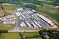 Scandinavian-Park Handewitt Luftbild.jpg 680 × 453; 207 kB
-
 Hann-Münden,Hedemünden.JPG 800 × 462; 76 kB
-
 Hann-Münden,Staufenberg.JPG 800 × 468; 88 kB
-
 Raststaette-Riedener-Wald 1583.JPG 3.872 × 2.592; 7,36 MB
-
 Raststaette-Riedener-Wald-1584Kopie.jpg 2.237 × 2.241; 3,47 MB
-
 Hersfeld-Rotenburg Niederaula Fuldatalbruecke Solms A7 89.png 7.401 × 1.560; 17,58 MB
-
 Hersfeld-Rotenburg Niederjossa A7 cyl pano N.png 10.513 × 2.243; 37,63 MB
-
 Kassel-Süd.JPG 800 × 421; 87 kB
-
 Kassel-West.JPG 800 × 424; 72 kB
-
 Kirchheim nord hessen.jpg 3.642 × 1.814; 516 kB
-
 Kreuz Bibelried in Fahrtrichtung Norden.jpg 4.032 × 2.394; 1,74 MB
-
 Kreuz Memmingen.png 3.086 × 2.792; 1,78 MB
-
 Lohfeldener-ruessel-autohof.jpg 2.272 × 1.368; 1,83 MB
-
 Luftbild Deutschland BAB 7 2010-07 01(RaBoe).jpg 803 × 1.200; 426 kB
-
 MautMessbruecke P1000300.jpg 1.280 × 960; 210 kB
-
 Nesselwang - Eggahöhe - A 7 - Anschluss Nesselwang 261014 - 02.jpg 4.000 × 2.248; 2,6 MB
-
 Niederaula aerial.jpg 2.816 × 2.112; 747 kB
-
 Quickborn - Gronau - E45 Dueker.jpg 2.487 × 1.858; 2,45 MB
-
 Rader Hochbrücke 18.11.2022.jpg 4.896 × 2.752; 4,1 MB
-
 Rastplatz Abelbeck.jpg 1.920 × 1.080; 2,09 MB
-
 Standstreifen auf der A7 bei km 557 während eines Verkehrsstaus (2).jpg 887 × 658; 232 kB
-
 Standstreifen auf der A7 bei km 557 während eines Verkehrsstaus.jpg 3.092 × 2.079; 7,6 MB
-
 Uttrichshausen gesehen aus Motten DSC02998.jpg 6.000 × 4.000; 3,02 MB

_bei_Dorfmark_-_geo.hlipp.de_-_6873.jpg)


_-_Garlstorf_900m_-_geo.hlipp.de_-_6923.jpg)
_-_Evendorf_-_Amelinghausen_-_geo.hlipp.de_-_6920.jpg)
_-_Evendorf_1000m_-_geo.hlipp.de_-_6893.jpg)
_-_Dreieck_Walsrode_2000m_-_geo.hlipp.de_-_6674.jpg)
_-_Westenholz_-_geo.hlipp.de_-_6624.jpg)
_Berkhorf,_1000m_-_geo.hlipp.de_-_6619.jpg)
_Mellendorf,_1100m_-_geo.hlipp.de_-_6618.jpg)
_-_geo.hlipp.de_-_14270.jpg)

_-_geo.hlipp.de_-_14296.jpg)
_-_geo.hlipp.de_-_14285.jpg)
_-_geo.hlipp.de_-_14306.jpg)
_-_geo.hlipp.de_-_14305.jpg)
_-_geo.hlipp.de_-_20766.jpg)
_-_geo.hlipp.de_-_20767.jpg)
_-_geo.hlipp.de_-_16182.jpg)
_-_geo.hlipp.de_-_16011.jpg)
_-_geo.hlipp.de_-_16012.jpg)

_-_geo.hlipp.de_-_14297.jpg)


_-_geo.hlipp.de_-_14005.jpg)


.jpg)


_-_Walsrode_-_geo.hlipp.de_-_6673.jpg)


_-_geo.hlipp.de_-_37339.jpg)

_Seevetal-Ramelsloh_(1000m)_-_geo.hlipp.de_-_4744.jpg)


.jpg)


.jpg)

