Category:Buriton
Vai alla navigazione
Vai alla ricerca
village and civil parish in Hampshire, United Kingdom  | |||||
| Carica un file multimediale | |||||
| Istanza di | |||||
|---|---|---|---|---|---|
| Luogo | East Hampshire, Hampshire, Sud Est dell'Inghilterra, Inghilterra | ||||
| Considerato essere uguale a | Buriton (pagina Wikimedia duplicata, parrocchia civile dell'Inghilterra) | ||||
 | |||||
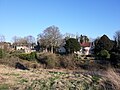
English: Buriton is a village and civil parish in the East Hampshire district of Hampshire, England, 2 miles (3.3 km) south of Petersfield. It lies just east of the A3 road.
Sottocategorie
Questa categoria contiene le 10 sottocategorie indicate di seguito, su un totale di 10.
B
- Buriton Chalk Pit (8 F)
- Buriton War Memorial (4 F)
F
- Five Bells pub, Buriton (9 F)
L
- William Lowth (3 F)
M
- The Manor House, Buriton (2 F)
N
- Nursted (2 F)
Q
File nella categoria "Buriton"
Questa categoria contiene 200 file, indicati di seguito, su un totale di 615.
(pagina precedente) (pagina successiva)-
 2016, a year on Geograph (Day 7) - geograph.org.uk - 4785811.jpg 640 × 480; 74 KB
-
 2016, a year on Geograph (Day 71) - geograph.org.uk - 4859405.jpg 640 × 480; 47 KB
-
 A Buriton hand - geograph.org.uk - 5259073.jpg 5 184 × 3 456; 7,66 MB
-
 A3 near Petersfield - geograph.org.uk - 4256117.jpg 640 × 339; 36 KB
-
 A3 near Queen Elizabeth Country Park - geograph.org.uk - 4256100.jpg 640 × 360; 37 KB
-
 A3 northbound - geograph.org.uk - 3052224.jpg 640 × 480; 56 KB
-
 A3 northbound - geograph.org.uk - 3052228.jpg 640 × 480; 39 KB
-
 A3 northbound - geograph.org.uk - 3052231.jpg 640 × 467; 52 KB
-
 A3 northbound - geograph.org.uk - 3052233.jpg 640 × 451; 53 KB
-
 A3 northbound - geograph.org.uk - 3052237.jpg 640 × 480; 48 KB
-
 A3 northbound - geograph.org.uk - 3052239.jpg 640 × 480; 42 KB
-
 A3 northbound - geograph.org.uk - 5888476.jpg 3 456 × 2 592; 2,18 MB
-
 A3 through the South Downs - geograph.org.uk - 4256103.jpg 640 × 430; 40 KB
-
 A3, approaching A272 turning - geograph.org.uk - 2794402.jpg 640 × 430; 44 KB
-
 A3, approaching Petersfield - geograph.org.uk - 2794394.jpg 640 × 361; 44 KB
-
 Alongside Appleton's Copse - geograph.org.uk - 4583199.jpg 1 142 × 857; 483 KB
-
 Appleton's Copse - geograph.org.uk - 2415403.jpg 4 000 × 3 000; 2,88 MB
-
 Approach to a roundabout near Buriton - geograph.org.uk - 2194897.jpg 800 × 600; 142 KB
-
 Approaching Coulters Dean Farm on the South Downs Way - geograph.org.uk - 2415423.jpg 4 000 × 3 000; 2,92 MB
-
 Approaching The Five Bells - geograph.org.uk - 2929312.jpg 640 × 480; 76 KB
-
 At Coulters Dean Farm - geograph.org.uk - 2415435.jpg 4 000 × 3 000; 2,82 MB
-
 B2146 - geograph.org.uk - 5208491.jpg 640 × 426; 89 KB
-
 B2146 - geograph.org.uk - 5208771.jpg 640 × 426; 107 KB
-
 Barn at Sunwood Farm - geograph.org.uk - 3729383.jpg 640 × 480; 177 KB
-
 Bend on bridleway near Dean's Farm - geograph.org.uk - 2215322.jpg 800 × 600; 201 KB
-
 Bluebell and white Bluebells in Buriton - geograph.org.uk - 6440009.jpg 4 288 × 3 216; 4,21 MB
-
 Bolinge Hill farm - geograph.org.uk - 5259212.jpg 5 202 × 3 465; 3,74 MB
-
 Bracket fungus on tree stump near Nursted House - geograph.org.uk - 6439997.jpg 3 216 × 4 288; 4,5 MB
-

-
 Bridleway at Dean's Farm - geograph.org.uk - 2215318.jpg 800 × 600; 155 KB
-
 Bridleway by farmhouse - geograph.org.uk - 2215312.jpg 800 × 600; 175 KB
-

-
 Bridleway near Cowdown Farm - geograph.org.uk - 354047.jpg 640 × 477; 116 KB
-
 Bridleway on Butser Hill - geograph.org.uk - 4581002.jpg 1 142 × 857; 315 KB
-
 Bridleway to Ditcham Woods - geograph.org.uk - 2274671.jpg 600 × 800; 218 KB
-

-
 Buildings at New Barn near Chalton - geograph.org.uk - 2232033.jpg 800 × 600; 155 KB
-
 Buildings at Old Ditcham Farm - geograph.org.uk - 2169307.jpg 800 × 600; 109 KB
-
 Tithe Barn, Old Ditcham Farm - geograph.org.uk - 415317.jpg 640 × 480; 91 KB
-
 Buriton - St Mary's Church ^ village pond - geograph.org.uk - 6005689.jpg 5 184 × 2 920; 5,71 MB
-
 Buriton Chalk Pits pond - geograph.org.uk - 3941807.jpg 4 320 × 3 240; 5,38 MB
-
 Buriton Chalk Pits, cutting and wagon - geograph.org.uk - 3941849.jpg 3 240 × 4 320; 3,71 MB
-
 Buriton Church - closed for the duration - geograph.org.uk - 6440020.jpg 4 288 × 3 216; 4,4 MB
-

-
 Buriton Churchyard, CWGC grave (a) - geograph.org.uk - 6240197.jpg 442 × 640; 80 KB
-
 Buriton Churchyard, CWGC grave (b) - geograph.org.uk - 6240198.jpg 461 × 640; 87 KB
-
 Buriton Churchyard, the 3rd grave - geograph.org.uk - 6240201.jpg 640 × 480; 120 KB
-
 Buriton Churchyard, The Squire's Grave - geograph.org.uk - 6240216.jpg 480 × 640; 136 KB
-
 Buriton County Primary School, Buriton, Hampshire.jpg 3 756 × 1 895; 1,85 MB
-
 Buriton from the railway - geograph.org.uk - 1237195.jpg 640 × 467; 76 KB
-
 Buriton High Street - geograph.org.uk - 3643035.jpg 1 064 × 1 600; 692 KB
-
 Buriton Pond and Church. - panoramio.jpg 4 000 × 3 000; 2,7 MB
-
 Buriton Pond from South Lane - geograph.org.uk - 3755623.jpg 640 × 427; 100 KB
-
 Buriton Pond, August 2019 - geograph.org.uk - 6243755.jpg 640 × 480; 92 KB
-
 Buriton Primary School - geograph.org.uk - 2929310.jpg 640 × 480; 102 KB
-
 Buriton Primary School, High Street, Buriton (July 2019).JPG 3 000 × 1 800; 2,15 MB
-
 Buriton Recreation Ground (July 2019).JPG 3 000 × 2 000; 2,26 MB
-

-

-

-
 Buriton School - closed for the duration - geograph.org.uk - 6440032.jpg 4 288 × 3 216; 3,99 MB
-
 Buriton Siding - geograph.org.uk - 2631471.jpg 640 × 430; 80 KB
-
 Buriton sign - geograph.org.uk - 5259206.jpg 4 573 × 3 219; 2,24 MB
-
 Buriton Village in 1990 - geograph.org.uk - 2961156.jpg 1 799 × 1 149; 2,36 MB
-
 Buriton Village Pond - geograph.org.uk - 6275279.jpg 6 663 × 4 442; 7,6 MB
-
 Buriton Village Pond - geograph.org.uk - 6275285.jpg 7 399 × 4 933; 6,48 MB
-
 Buriton village pond - geograph.org.uk - 98751.jpg 640 × 434; 119 KB
-
 Buriton Village Pond from St. Mary the Virgin Church - geograph.org.uk - 6275341.jpg 5 991 × 3 994; 6,43 MB
-
 Buriton Village Pond, Heron - geograph.org.uk - 6275288.jpg 5 226 × 3 485; 3,44 MB
-
 Buriton War Memorial - geograph.org.uk - 6275274.jpg 4 645 × 6 967; 7,03 MB
-
 Buriton War Memorial, late April 2019 - geograph.org.uk - 6134548.jpg 640 × 480; 122 KB
-
 Buriton, Hampshire 01.jpg 4 128 × 3 096; 5,89 MB
-
 Buriton, Hampshire 03.jpg 4 128 × 3 096; 9,68 MB
-
 Buriton, Hampshire 04.jpg 4 128 × 3 096; 10,98 MB
-
 Buriton, Hampshire 05.jpg 4 128 × 3 096; 7,22 MB
-
 Buriton, Junction of Kiln Lane and High Street - geograph.org.uk - 5259196.jpg 4 392 × 3 044; 2,5 MB
-
 Buriton, on the Hangers Way. - geograph.org.uk - 179892.jpg 432 × 640; 159 KB
-
 Buriton, Rough grassland set aside for nature - geograph.org.uk - 6275335.jpg 5 885 × 3 924; 6,67 MB
-
 Buriton, St. Mary the Virgin Church - geograph.org.uk - 6275258.jpg 7 396 × 4 932; 7,44 MB
-
-

-

-

-

-

-
 Buriton, St. Mary the Virgin Church, Southern aspect - geograph.org.uk - 6275262.jpg 6 678 × 4 451; 6,75 MB
-
 Buriton, St. Mary the Virgin Church, Southern aspect - geograph.org.uk - 6275268.jpg 6 382 × 4 254; 6,97 MB
-
 Buriton, St. Mary the Virgin Church, Stained glass window - geograph.org.uk - 6275332.jpg 3 752 × 5 628; 4,15 MB
-

-
 Buriton, St. Mary the Virgin Church, The c12th nave - geograph.org.uk - 6275290.jpg 6 898 × 4 598; 6,8 MB
-
 Buriton, St. Mary the Virgin Church, The chancel (1280) - geograph.org.uk - 6275294.jpg 4 922 × 7 384; 7,8 MB
-
 Bus shelter in the High Street - geograph.org.uk - 2929318.jpg 640 × 480; 133 KB
-
 Butser Ancient Farm - geograph.org.uk - 2925126.jpg 2 520 × 1 680; 480 KB
-
 Butser Hill - geograph.org.uk - 2925165.jpg 2 520 × 1 680; 281 KB
-
 Butser Hill - View north-northeast - geograph.org.uk - 4578354.jpg 1 503 × 1 000; 1,01 MB
-
 Butser Hill - View southwards - geograph.org.uk - 4578328.jpg 1 364 × 1 000; 1,11 MB
-
 Butser Hill from Stoner Hill - geograph.org.uk - 39938.jpg 640 × 480; 100 KB
-
 Byre at Round Copse - geograph.org.uk - 6440051.jpg 4 288 × 3 216; 4,26 MB
-
 Byway near Sunwood Farm - geograph.org.uk - 2169390.jpg 800 × 600; 193 KB
-
 Conifers, Ditcham Woods - geograph.org.uk - 2691186.jpg 640 × 430; 114 KB
-
 Copper Beeches at Sunwood Farm - geograph.org.uk - 2407567.jpg 4 320 × 3 240; 4,66 MB
-
 Cottage north of Buriton - geograph.org.uk - 2169255.jpg 800 × 600; 142 KB
-
 Coulter's Dean - geograph.org.uk - 356085.jpg 640 × 477; 153 KB
-
 Coulters Dean Farm - geograph.org.uk - 1360317.jpg 640 × 480; 125 KB
-
 Countryside near Buriton - geograph.org.uk - 2631469.jpg 640 × 304; 35 KB
-
 Craftsman in the village hall - geograph.org.uk - 2926241.jpg 640 × 480; 86 KB
-
 Crossroads in the centre of Buriton - geograph.org.uk - 2923914.jpg 1 600 × 1 200; 602 KB
-
 Crow haranguing Buzzards in the lee of Butser Hill - geograph.org.uk - 6433372.jpg 6 016 × 4 000; 5,84 MB
-

-
 Cycling through Buriton - geograph.org.uk - 2961165.jpg 1 799 × 1 196; 2,87 MB
-
 Cyclist on the B2146 - geograph.org.uk - 6243790.jpg 640 × 480; 71 KB
-
 Cyclists toiling up Kiln Lane - geograph.org.uk - 2920962.jpg 640 × 480; 94 KB
-

-
 Dead end road to Dean Barn - geograph.org.uk - 2920982.jpg 640 × 480; 98 KB
-
 Dead tree and two healthy trees near Pilmead Row - geograph.org.uk - 6440000.jpg 4 288 × 3 216; 4,48 MB
-
 Descent into Downley Bottom - geograph.org.uk - 2274666.jpg 800 × 600; 91 KB
-
 Descent to Sunwood Farm - geograph.org.uk - 4583208.jpg 1 142 × 857; 354 KB
-
 Direction sign on the Petersfield Road - geograph.org.uk - 5259465.jpg 5 202 × 3 465; 4,22 MB
-
 Ditcham Park School - geograph.org.uk - 3729566.jpg 640 × 428; 145 KB
-
 Ditcham Woods - geograph.org.uk - 2691188.jpg 640 × 430; 121 KB
-
 Dry ditch at Buriton - geograph.org.uk - 3755626.jpg 640 × 427; 127 KB
-
 Ducks crossing^ - geograph.org.uk - 3755732.jpg 640 × 427; 91 KB
-
 Ducks on the village pond at Buriton - geograph.org.uk - 2920153.jpg 3 968 × 2 976; 2,77 MB
-
 East Hampshire , Liphook and Petersfield Bypass A3 - geograph.org.uk - 5739005.jpg 6 000 × 4 000; 6,47 MB
-
 East Hampshire , Liphook and Petersfield Bypass A3 - geograph.org.uk - 5739006.jpg 6 000 × 4 000; 6,17 MB
-
 East Hampshire , Liphook and Petersfield Bypass A3 - geograph.org.uk - 5739008.jpg 6 000 × 4 000; 6,54 MB
-
 East Hampshire , London Road A3 - geograph.org.uk - 5738998.jpg 6 000 × 4 000; 6,92 MB
-
 East Hampshire , London Road A3 - geograph.org.uk - 5739001.jpg 6 000 × 4 000; 6,3 MB
-
 East Hampshire , London Road A3 - geograph.org.uk - 5739002.jpg 6 000 × 4 000; 6,3 MB
-
 East Hampshire , London Road A3 - geograph.org.uk - 5739003.jpg 6 000 × 4 000; 6,6 MB
-
 East Hampshire , London Road A3 - geograph.org.uk - 5739004.jpg 6 000 × 4 000; 6,66 MB
-
 East Meon's church of All Saints from Butser Hill - geograph.org.uk - 4577440.jpg 1 043 × 1 000; 875 KB
-
 Eastward View along Buriton High Street (July 2019).JPG 2 800 × 1 800; 1,74 MB
-
 Eckensfield - geograph.org.uk - 354083.jpg 640 × 477; 70 KB
-
 Emerging into sunlight near Sunwood Farm - geograph.org.uk - 4583205.jpg 1 142 × 857; 431 KB
-
 Entering Buriton on Petersfield Road - geograph.org.uk - 2923910.jpg 1 600 × 1 200; 597 KB
-
 Entering Sussex on the south downs Way - geograph.org.uk - 2415543.jpg 4 000 × 3 000; 2,86 MB
-
 Entrance at Faggs Farm - geograph.org.uk - 2232092.jpg 600 × 800; 147 KB
-

-
 Entrance to Buriton Manor House - geograph.org.uk - 2671.jpg 640 × 480; 88 KB
-
 Exercising the horse during the Coronavirus lockdown - geograph.org.uk - 6433317.jpg 6 016 × 4 000; 6,23 MB
-
 Fallen tree in Nursted Copse - geograph.org.uk - 6439977.jpg 4 288 × 3 216; 4,5 MB
-
 Farm pond - geograph.org.uk - 6433319.jpg 6 016 × 4 000; 6,3 MB
-
 Farm track (wet) - geograph.org.uk - 2169417.jpg 800 × 600; 139 KB
-
 Farm track on West Harting Down - geograph.org.uk - 2274661.jpg 800 × 600; 108 KB
-
 Farmland East of Buriton - geograph.org.uk - 6237510.jpg 4 608 × 3 456; 6,41 MB
-
 Farmland near Weston - geograph.org.uk - 2631467.jpg 640 × 430; 38 KB
-
 Field at Old Ditcham - geograph.org.uk - 2169333.jpg 800 × 600; 126 KB
-
 Field south of Buriton - geograph.org.uk - 2169215.jpg 800 × 600; 98 KB
-
 Field West of the A3 - geograph.org.uk - 6433046.jpg 6 016 × 4 000; 6,25 MB
-
 Finger post at the top of Kiln Lane - geograph.org.uk - 2923467.jpg 640 × 480; 100 KB
-
 Fire break on War Down - geograph.org.uk - 4194381.jpg 800 × 572; 104 KB
-
 Five Bells, Buriton - geograph.org.uk - 5259183.jpg 5 202 × 3 465; 4,19 MB
-
 Footpath by cottage in Buriton - geograph.org.uk - 2169252.jpg 800 × 600; 152 KB
-

-
 Footpath from Buriton to Chalton - geograph.org.uk - 5398660.jpg 478 × 640; 185 KB
-
 Footpath from Chalton to Buriton - geograph.org.uk - 5398676.jpg 478 × 640; 179 KB
-
 Footpath from the car park - geograph.org.uk - 3941166.jpg 1 200 × 900; 730 KB
-

-
 Footpath on drive at Nursted - geograph.org.uk - 2169276.jpg 800 × 600; 167 KB
-
 Footpath signpost - geograph.org.uk - 354063.jpg 477 × 640; 126 KB
-
 Footpath signpost, Stubb's Copse - geograph.org.uk - 2691177.jpg 640 × 430; 120 KB
-
 Footpath south from Buriton - geograph.org.uk - 3755627.jpg 427 × 640; 70 KB
-
-
 Footpath to Copyhold Barn - geograph.org.uk - 3763957.jpg 640 × 480; 157 KB
-
 Footpath to New Barn Lane - geograph.org.uk - 3726752.jpg 640 × 480; 249 KB
-
 Forest track, Ditcham Woods - geograph.org.uk - 2691196.jpg 640 × 430; 95 KB
-

-

-
 Gate on bridleway at Dean's Farm - geograph.org.uk - 2215315.jpg 800 × 572; 147 KB
-
 Glimpse of Butser Hill from the east side of the A3 - geograph.org.uk - 2921121.jpg 3 968 × 2 976; 2,82 MB
-

-
 Going uphill - geograph.org.uk - 5455535.jpg 800 × 600; 160 KB
-
 Gravelhill Bottom - geograph.org.uk - 1891189.jpg 2 816 × 2 112; 2,1 MB
-
 Gravestones in Buriton Churchyard - geograph.org.uk - 6135291.jpg 640 × 480; 125 KB
-
 Green space opposite St Mary's church, Buriton - geograph.org.uk - 5259080.jpg 5 202 × 3 465; 5,47 MB
-
 Greenway Lane, Buriton - geograph.org.uk - 2924899.jpg 1 600 × 1 200; 303 KB
-
 Hampshire-Sussex border at Nursted - geograph.org.uk - 6243785.jpg 640 × 480; 99 KB
-
 Hangars Way approaching Buriton - geograph.org.uk - 5259068.jpg 5 202 × 3 465; 4,05 MB
-
 Hangars Way at the edge of the woods - geograph.org.uk - 5259065.jpg 5 202 × 3 465; 5,6 MB
-
 Hangars Way between a ploughed field and a stream - geograph.org.uk - 5257631.jpg 5 202 × 3 465; 4,69 MB
-
 Hangars Way footbridge - geograph.org.uk - 5257629.jpg 5 202 × 3 465; 5,08 MB
-
 Hangars Way looking Northwards - geograph.org.uk - 5259063.jpg 5 202 × 3 465; 6,33 MB
-
 Hangars Way near Hoadlands Crundle - geograph.org.uk - 5257637.jpg 5 202 × 3 465; 4,05 MB
-
 Hangars Way stile - geograph.org.uk - 5257632.jpg 5 202 × 3 465; 4,33 MB
-
 Hangars Way, looking north from Buriton - geograph.org.uk - 5259070.jpg 5 202 × 3 465; 5,32 MB
-
 Hangars Way, looking towards Furzefield Copse - geograph.org.uk - 5259056.jpg 5 202 × 3 465; 5 MB
-

-
 High Street, Buriton (1) - geograph.org.uk - 2961006.jpg 3 872 × 2 592; 4,74 MB
-
 High Street, Buriton (2) - geograph.org.uk - 2961015.jpg 3 872 × 2 592; 4,73 MB
-
 High Street, Buriton - geograph.org.uk - 3755618.jpg 640 × 427; 88 KB
-
 High Street, Buriton - geograph.org.uk - 5259176.jpg 5 184 × 3 456; 6,66 MB
-
 Hilhampton Bottom - geograph.org.uk - 4581024.jpg 1 469 × 1 102; 511 KB
-
 House at Old Ditcham - geograph.org.uk - 2169347.jpg 800 × 600; 142 KB
-

-
 House by Buriton Church - geograph.org.uk - 3647181.jpg 1 600 × 1 064; 495 KB
-
 House on Sussex Road at Nursted - geograph.org.uk - 2169284.jpg 800 × 600; 142 KB
-
 Houses on North Lane, Buriton - geograph.org.uk - 6440004.jpg 4 288 × 3 216; 4,03 MB
-
 Hundry Copse - geograph.org.uk - 2631470.jpg 640 × 430; 63 KB
-
 In Ditcham Woods - geograph.org.uk - 354146.jpg 477 × 640; 140 KB
_-_geograph.org.uk_-_4785811.jpg)
_-_geograph.org.uk_-_4859405.jpg)


_-_geograph.org.uk_-_6240197.jpg)
_-_geograph.org.uk_-_6240198.jpg)


.JPG)
.JPG)


_-_geograph.org.uk_-_6275294.jpg)


.JPG)


_-_geograph.org.uk_-_2169417.jpg)


_-_geograph.org.uk_-_2961006.jpg)
_-_geograph.org.uk_-_2961015.jpg)


