Category:Cantino map
Vai alla navigazione
Vai alla ricerca
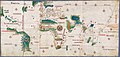
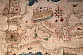
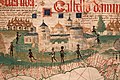
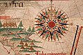
earliest surviving map showing Portuguese Discoveries in the east and west  | |||||
| Carica un file multimediale | |||||
| Istanza di | |||||
|---|---|---|---|---|---|
| Prende il nome da |
| ||||
| Altezza |
| ||||
| |||||
Images related to Cantino world map, 1502
File nella categoria "Cantino map"
Questa categoria contiene 42 file, indicati di seguito, su un totale di 42.
-
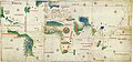
 Cantino west.jpg 1 186 × 1 202; 1,34 MB
-
 1502 Cantino Antillas.png 1 405 × 899; 2,9 MB
-
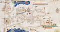
 1502 Cantino.jpg 2 521 × 1 200; 2,9 MB
-
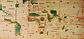
 Africa cantino.JPG 754 × 581; 118 KB
-

-

-

-

-

-
-

-

-

-
-
-

-

-

-

-

-

-
 Antillas en Cantino y de la Cosa (Valentini, 1889).gif 805 × 700; 38 KB
-
 Cantino - Americas.jpg 468 × 600; 239 KB
-
 Cantino planisphere (1502).jpg 10 643 × 4 998; 35,99 MB
-
 Cantino Planisphere.jpg 640 × 299; 44 KB
-
 Cantino rhumb line system.JPG 3 500 × 1 644; 5,03 MB
-
 Cantino windrose.jpg 1 645 × 1 973; 960 KB
-
 Cantino.png 450 × 584; 494 KB
-
 Cantinomap redsea persiangulf.jpg 666 × 605; 318 KB
-
 CantinoPlanisphere Black Sea.png 352 × 230; 188 KB
-
 CantinoPlanisphere Europe.png 920 × 489; 1,06 MB
-
 CantinoPlanisphere Middle East.png 420 × 198; 204 KB
-
 CantinoPlanisphere-Mascareignes.png 281 × 187; 121 KB
-
 CantinoPlanisphere.png 3 528 × 1 656; 11,88 MB
-
 Compass grid Cantino planisphere (1502).jpg 3 528 × 1 656; 3,34 MB
-
 Compass rose Cantino.jpg 709 × 787; 580 KB
-
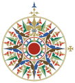 Compass rose Cantino.svg 1 050 × 1 160; 147 KB
-
 Guadeloupe sur planisphère de Cantino 1502.jpg 720 × 540; 55 KB
-
 Map1502cantino-eelam.jpg 566 × 637; 203 KB
-
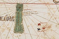
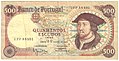 Portugal 500 escudos 20880.jpg 1 184 × 605; 926 KB
-

-


,_1501-02_(bibl._estense)_01.jpg)
,_1501-02_(bibl._estense)_02.jpg)
,_1501-02_(bibl._estense)_03.jpg)
,_1501-02_(bibl._estense)_04.jpg)
,_1501-02_(bibl._estense)_05.jpg)
,_1501-02_(bibl._estense)_06.jpg)
,_1501-02_(bibl._estense)_07_italia.jpg)
,_1501-02_(bibl._estense)_08.jpg)
,_1501-02_(bibl._estense)_09_canarie.jpg)
,_1501-02_(bibl._estense)_10_africani.jpg)
,_1501-02_(bibl._estense)_11.jpg)
,_1501-02_(bibl._estense)_12.jpg)
,_1501-02_(bibl._estense)_13_mar_rosso.jpg)
,_1501-02_(bibl._estense)_14_faro_di_alessandria.jpg)
,_1501-02_(bibl._estense)_15_gerusalemme.jpg)
,_1501-02_(bibl._estense)_16.jpg)
,_1501-02_(bibl._estense)_17.jpg)
.gif)

.jpg)


.jpg)


_-_par_Alberto_CantinoDe_la_grandeur_de_l%27original_(Biblioteca_Estense_%C3%A0_Mod%C3%A8ne)_-_btv1b530226731.jpg)
_-_par_Alberto_CantinoDe_la_grandeur_de_l%27original_(Biblioteca_Estense_%C3%A0_Mod%C3%A8ne)_-_btv1b5970559x.jpg)