Category:Cape Fold Belt
Vai alla navigazione
Vai alla ricerca
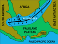
A late Paleozoic fold and thrust belt in southwestern South Africa  | |||||
| Carica un file multimediale | |||||
| Istanza di | |||||
|---|---|---|---|---|---|
| Luogo | provincia del Capo Occidentale, Sudafrica | ||||
| Consiste di |
| ||||
| Punto più alto |
| ||||
 | |||||
Afrikaans: Kaapse plooiberge
Sottocategorie
Questa categoria contiene le 14 sottocategorie indicate di seguito, su un totale di 14.
*
B
- Blousteenberge (3 F)
C
D
H
- Hex River Pass (5 F)
L
M
- Meiringspoort (26 F)
O
R
- Riviersonderend Mountains (8 F)
S
T
- Tsitsikamma Mountains (9 F)
File nella categoria "Cape Fold Belt"
Questa categoria contiene 44 file, indicati di seguito, su un totale di 44.
-
 Cape Orogeny A5.png 1 275 × 666; 23 KB
-
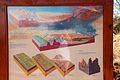
 Formation of Cape Fold Mountains.jpg 4 921 × 5 061; 942 KB
-
 Map of Karoo.png 8 151 × 5 772; 634 KB
-
 South African Geology - Schwarz - 1912 Fig 34.png 774 × 450; 253 KB
-
 South African Geology - Schwarz - 1912 Fig 37.png 707 × 618; 193 KB
-
 South African Geology - Schwarz - 1912 Fig 39, Groot River.png 1 005 × 734; 1 023 KB
-
 South African Geology - Schwarz - 1912 Fig 39.png 1 263 × 770; 1 017 KB
-
 Southern Gondwana.png 3 997 × 3 017; 1,95 MB
-
 The Escarpment and the Drakensberg.jpg 9 960 × 6 756; 3,08 MB
-
 Valley of Desolation-051.jpg 1 800 × 1 200; 785 KB
-
 Valley of Desolation-052.jpg 1 800 × 1 200; 810 KB
-
 Western Cape Topology and boundary.jpg 8 000 × 6 372; 9,2 MB
-
 Western Cape Topology.jpg 1 498 × 1 197; 930 KB
-
 1 Buffelspoort - buffels river.JPG 1 024 × 683; 506 KB
-
 1 Buffelspoort - southern entrance - RSA.jpg 1 024 × 699; 263 KB
-
 1 Fan Aloe trees in Western Cape mountains - South Africa.jpg 2 441 × 3 472; 1,77 MB
-
 Agulhas-Map.jpg 600 × 500; 88 KB
-
 AT1203 map.png 1 082 × 834; 31 KB
-
 Bosluiskloof01.jpg 1 024 × 768; 158 KB
-
 Cape Floral Region Protected Areas map.jpg 2 730 × 1 116; 561 KB
-
 Cape fold keerom koo.jpg 1 148 × 616; 45 KB
-
 Cape Town 2012 05 13 0271 (7179911151).jpg 3 872 × 2 592; 6,01 MB
-
 Cederberg geology.jpg 2 000 × 1 160; 315 KB
-
 Contrasts - fire.jpg 3 992 × 2 242; 7,47 MB
-
 Earth's geolological timeline-fr.svg 990 × 330; 9 KB
-
 Earth's geolological timeline.svg 990 × 330; 5 KB
-
 Erosion A5.gif 1 275 × 696; 22 KB
-
 Erosion A5.svg 640 × 350; 40 KB
-
 Eureka SA.jpg 1 055 × 624; 68 KB
-
 Folded rock at Storms River Mouth P7144635.JPG 3 648 × 2 736; 2,29 MB
-
 George seen from Outeniqua Pass (31974275434).jpg 5 307 × 3 538; 7,13 MB
-
 Kammaskloof 1.jpg 829 × 622; 102 KB
-
 Kink bands.jpg 3 648 × 2 736; 3,05 MB
-
 Langkloof00.jpg 781 × 547; 137 KB
-
 Leucadendron rourkei 15539957.jpg 692 × 1 037; 154 KB
-
 Lone Soldier - panoramio.jpg 2 560 × 1 920; 1,61 MB
-
 N Buffelspoort slopes 2.jpg 1 024 × 768; 440 KB
-
 Newlands Graafwater.jpg 723 × 1 000; 252 KB
-
 Ou Kaapse weg.jpg 1 000 × 667; 209 KB
-
 PICT3099 Hills Ladismith.JPG 2 272 × 1 704; 1,48 MB
-
 Route 62 between Montagu and Ashton - panoramio.jpg 1 440 × 900; 1,05 MB
-
 SwartbergPICT3193.JPG 2 272 × 1 704; 2,73 MB
-
 View from Route 62 - panoramio.jpg 1 440 × 900; 1,19 MB
-
 Visite, pg076 Approach to Gnadenthal, crossing the river Sonderemd.jpg 2 421 × 1 635; 2,34 MB


.jpg)


.jpg)


