Category:Castle Harbour, Bermuda
Salti al navigilo
Salti al serĉilo
large natural harbour in Bermuda   | |||||
| Alŝuti plurmedion | |||||
| Estas | |||||
|---|---|---|---|---|---|
| Loko | Bermudo, Britaj transmaraj teritorioj, Unuiĝinta Reĝlando (Britio) | ||||
 | |||||
Dosieroj en kategorio “Castle Harbour, Bermuda”
La jenaj 9 dosieroj estas en ĉi tiu kategorio, el 9 entute.
-
 Admiralty Chart No 867 The Narrows to Grassy Bay, Published 1941.jpg 18 502 × 12 075; 55,79 MB
-
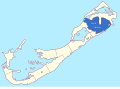
 Bmmap-Castleharbor.png 800 × 597; 129 KB
-
 Castle Harbour, Bermuda.svg 800 × 590; 105 KB
-
 Castle Harbour.jpg 320 × 240; 17 KB
-
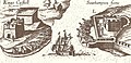 Castle Roads from John Smith map -1624.jpg 641 × 310; 199 KB
-
 CastleHarbour.jpg 2 592 × 1 944; 606 KB
-
-
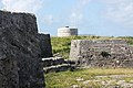
 PSM V60 D034 Ruined fort on castle island bermuda.png 1 584 × 1 286; 462 KB
-
 Somers Isles Map by John Speed 1676 - Parish of St George.jpg 769 × 966; 468 KB


