Category:Castlereagh
Zur Navigation springen
Zur Suche springen
Districts of Northern Ireland (1972-2015): Antrim · Ards · Armagh · Ballymena · Ballymoney · Banbridge · Belfast · Carrickfergus · Castlereagh · Coleraine · Cookstown · Craigavon · Derry · Down · Dungannon and South Tyrone · Fermanagh · Larne · Limavady · Lisburn · Magherafelt · Moyle · Newtownabbey · Newry and Mourne · North Down · Omagh · Strabane ·
nordirischer District  | |||||
| Medium hochladen | |||||
| Ist ein(e) |
| ||||
|---|---|---|---|---|---|
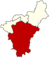
| Ort | Lisburn and Castlereagh, Nordirland | ||||
| Fläche |
| ||||
| Religion oder Weltanschauung | |||||
| Verschieden von | |||||
| offizielle Website | |||||
 | |||||
Unterkategorien
Es werden 4 von insgesamt 4 Unterkategorien in dieser Kategorie angezeigt:
In Klammern die Anzahl der enthaltenen Kategorien (K), Seiten (S), Dateien (D)
Medien in der Kategorie „Castlereagh“
Folgende 134 Dateien sind in dieser Kategorie, von 134 insgesamt.
-
 BENN(1823) p305 THE KEMPE STONES, PARISH OF NEWTOWNARDS.jpg 1.531 × 1.146; 1,15 MB
-
 Ballymalady Townland - geograph.org.uk - 930458.jpg 640 × 480; 45 KB
-
 Barley field, Castlereagh - geograph.org.uk - 912303.jpg 640 × 611; 413 KB
-
 Barren land in Ouley Townland - geograph.org.uk - 1617937.jpg 640 × 480; 87 KB
-
 Bells Bridge, Cregagh Road - geograph.org.uk - 1392943.jpg 640 × 480; 99 KB
-
 Belvoir Park flats, Belfast - geograph.org.uk - 1275425.jpg 640 × 351; 66 KB
-
 Bench Mark, Belfast - geograph.org.uk - 1766990.jpg 640 × 480; 487 KB
-
 Bollard, Lagan towpath - geograph.org.uk - 1622944.jpg 547 × 640; 469 KB
-
 Canberra Gardens, Dundonald - geograph.org.uk - 1705515.jpg 640 × 480; 85 KB
-
 Canberra Park, Dundonald - geograph.org.uk - 1705511.jpg 640 × 480; 95 KB
-
 Castlereagh - 2001.png 576 × 546; 32 KB
-
 Castlereagh - 2005.png 576 × 546; 32 KB
-
 Castlereagh - 2011.png 576 × 546; 32 KB
-
 Castlereagh 1993 blank.svg 392 × 467; 126 KB
-
 Castlereagh 1993 Castlereagh Central highlight.svg 392 × 467; 126 KB
-
 Castlereagh 1993 Castlereagh East highlight.svg 392 × 467; 126 KB
-
 Castlereagh 1993 Castlereagh South highlight.svg 392 × 467; 126 KB
-
 Castlereagh 1993 Castlereagh West highlight.svg 392 × 467; 126 KB
-
 Castlereagh 2005 election.svg 1.156 × 851; 148 KB
-
 Castlereagh 2011 election.svg 1.156 × 851; 150 KB
-
 Castlereagh gospel hall, Belfast - geograph.org.uk - 3870114.jpg 640 × 385; 94 KB
-

-

-
-
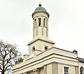
 Castlereagh Presbyterian Church - geograph.org.uk - 107824.jpg 640 × 480; 97 KB
-
 Castlereagh Valley (6323256275).jpg 764 × 1.024; 574 KB
-
 Cherryhill Crescent, Dundonald - geograph.org.uk - 1705529.jpg 640 × 480; 61 KB
-
 Cherryhill Park, Dundonald - geograph.org.uk - 1705521.jpg 640 × 480; 94 KB
-
 Cherryhill Road, Dundonald - geograph.org.uk - 1705493.jpg 3.648 × 2.736; 4,03 MB
-
 Cherryhill Road, Dundonald - geograph.org.uk - 1705527.jpg 640 × 480; 68 KB
-
 Church Road, Castlereagh - geograph.org.uk - 912310.jpg 640 × 480; 374 KB
-
 Church Road, Newtownbreda (2) - geograph.org.uk - 799554.jpg 640 × 574; 477 KB
-
 Commons Brae, Belfast - geograph.org.uk - 1504750.jpg 640 × 480; 122 KB
-
 Cregagh Estate - panoramio.jpg 2.520 × 1.448; 2,17 MB
-
 Dunlady Road, Dundonald - geograph.org.uk - 1706256.jpg 3.648 × 2.736; 1,94 MB
-
 Dunleady Park, Dundonald - geograph.org.uk - 1706244.jpg 3.555 × 2.662; 1,97 MB
-
 Entrance to Disused Radio Station - geograph.org.uk - 936226.jpg 640 × 480; 71 KB
-
 Field gate near Belfast - geograph.org.uk - 3870392.jpg 622 × 415; 114 KB
-
 Fields and hedges near Belfast - geograph.org.uk - 3870285.jpg 640 × 379; 96 KB
-
 Floodlighting, Clement Wilson Park - geograph.org.uk - 1490139.jpg 427 × 640; 36 KB
-
 Flush Bracket, Belfast - geograph.org.uk - 1763938.jpg 580 × 640; 229 KB
-

-
 Forestside Shopping Centre - geograph.org.uk - 1392457.jpg 640 × 480; 82 KB
-
 George Best mural, Cregagh Estate - geograph.org.uk - 1392923.jpg 640 × 480; 73 KB
-
 Glendale Avenue North, Belfast - geograph.org.uk - 1505168.jpg 640 × 480; 87 KB
-
 Government Offices, Ladas Drive - geograph.org.uk - 1392977.jpg 640 × 480; 79 KB
-
 Gransha Road - geograph.org.uk - 1519438.jpg 640 × 480; 82 KB
-
 Greenway, Cregagh Road - geograph.org.uk - 1392936.jpg 640 × 480; 91 KB
-
-

-
-

-
-
-
 Lagan navigation restoration (11) - geograph.org.uk - 1534948.jpg 637 × 420; 128 KB
-
 Lagan navigation restoration (12) - geograph.org.uk - 1535078.jpg 637 × 420; 150 KB
-
 Lagan navigation restoration (2) - geograph.org.uk - 1533868.jpg 640 × 361; 109 KB
-
 Lagan navigation restoration (6) - geograph.org.uk - 1534179.jpg 637 × 420; 119 KB
-
 Lagan navigation restoration (7) - geograph.org.uk - 1534696.jpg 640 × 401; 144 KB
-
 Lagan navigation restoration (8) - geograph.org.uk - 1534733.jpg 640 × 400; 126 KB
-
 Lagan navigation restoration (9) - geograph.org.uk - 1534759.jpg 640 × 355; 128 KB
-
 Lisburn and Castlereagh Castlereagh East highlight.svg 473 × 378; 508 KB
-
 Lisburn and Castlereagh Castlereagh South highlight.svg 473 × 378; 508 KB
-
 Lock no 2, disused Lagan Navigation (2) - geograph.org.uk - 909287.jpg 620 × 415; 104 KB
-
 Lock no 2, disused Lagan Navigation - geograph.org.uk - 909264.jpg 640 × 424; 117 KB
-
 Lock restoration, Newforge, Belfast - geograph.org.uk - 1514976.jpg 640 × 429; 112 KB
-
 Loop River at Ladas Drive - geograph.org.uk - 1392981.jpg 640 × 480; 152 KB
-
 Loopriver Play Centre, Ladas Way - geograph.org.uk - 1392989.jpg 640 × 480; 76 KB
-
 Manse Road, Four Winds, Belfast - geograph.org.uk - 1505067.jpg 640 × 480; 82 KB
-
 Mill Road West near Purdysburn - geograph.org.uk - 810427.jpg 640 × 509; 385 KB
-
 Milltown Hill, Ballynahatty - geograph.org.uk - 756970.jpg 640 × 524; 159 KB
-
 Milltown Hill, Belvoir - geograph.org.uk - 756961.jpg 640 × 494; 117 KB
-
 Mount Merrion Avenue, Rosetta - geograph.org.uk - 1392500.jpg 640 × 480; 92 KB
-
 Mount Merrion Gardens - geograph.org.uk - 1392505.jpg 640 × 480; 94 KB
-
 Newton Park, Four Winds, Belfast - geograph.org.uk - 1505070.jpg 640 × 480; 104 KB
-
 Newton Park, Four Winds, Belfast - geograph.org.uk - 1505072.jpg 640 × 480; 86 KB
-
 Newton Park, Four Winds, Belfast - geograph.org.uk - 1505167.jpg 640 × 480; 113 KB
-
 Newton Park, Four Winds, Belfast - geograph.org.uk - 1505169.jpg 640 × 480; 94 KB
-
 Newtownbreda Road, Belfast - geograph.org.uk - 799543.jpg 640 × 508; 440 KB
-
 No-through road sign, Dundonald - geograph.org.uk - 1706237.jpg 3.648 × 2.736; 2,36 MB
-

-
 Old railway at Dundonald - geograph.org.uk - 1139500.jpg 640 × 363; 89 KB
-
 Old sign, Cherryhill Road, Dundonald - geograph.org.uk - 1705576.jpg 3.648 × 2.736; 2,66 MB
-
 Overgrown Public Park, Ladas Drive - geograph.org.uk - 1392975.jpg 640 × 480; 148 KB
-
 Path, Minnowburn, Belfast - geograph.org.uk - 1555466.jpg 602 × 413; 128 KB
-

-

-
 Road at Monlough - geograph.org.uk - 930468.jpg 640 × 480; 47 KB
-
 Robbs Road, Dundonald - geograph.org.uk - 1706276.jpg 3.648 × 2.736; 2,59 MB
-

-
 Rossdale Glen, Four Winds, Belfast - geograph.org.uk - 1504985.jpg 640 × 480; 96 KB
-
 Rossdale Road, Four Winds, Belfast - geograph.org.uk - 1504978.jpg 640 × 480; 91 KB
-

-
 Shops at Commons Brae, Belfast - geograph.org.uk - 1504748.jpg 640 × 480; 98 KB
-

-
 Shops, Cherryhill, Dundonald - geograph.org.uk - 1404380.jpg 640 × 480; 58 KB
-
 Sign, Dunleady Park, Dundonald - geograph.org.uk - 1706246.jpg 3.648 × 2.736; 2,59 MB
-
 South Bank, Cregagh Estate - geograph.org.uk - 1392808.jpg 640 × 480; 85 KB
-
 Stream, Castlereagh-Belfast (1) - geograph.org.uk - 3870236.jpg 640 × 401; 153 KB
-
 Stream, Castlereagh-Belfast (2) - geograph.org.uk - 3870238.jpg 640 × 424; 140 KB
-
 The Ballygowan Road near Belfast - geograph.org.uk - 3870264.jpg 640 × 373; 99 KB
-
 The Ballygowan Road, Castlereagh-Belfast - geograph.org.uk - 3870206.jpg 640 × 373; 114 KB
-
 The Ballylesson Road near Belfast (3) - geograph.org.uk - 1167191.jpg 625 × 417; 104 KB
-
 The Ballylesson Road near Belfast (4) - geograph.org.uk - 1482925.jpg 640 × 405; 105 KB
-
 The Carrowreagh Road, Dundonald - geograph.org.uk - 735214.jpg 640 × 393; 65 KB
-
 The Comber Greenway (12) - geograph.org.uk - 1139402.jpg 640 × 381; 101 KB
-
 The Comber Greenway, Dundonald (2) - geograph.org.uk - 1690420.jpg 640 × 400; 106 KB
-
 The Comber Greenway, Dundonald - geograph.org.uk - 1690379.jpg 614 × 340; 91 KB
-
 The countryside above Dundonald - geograph.org.uk - 741993.jpg 640 × 373; 92 KB
-
 The Dunlady Road near Dundonald - geograph.org.uk - 741978.jpg 640 × 380; 89 KB
-
 The Dunlady Road, Dundonald - geograph.org.uk - 741958.jpg 640 × 380; 73 KB
-
 The Edenderry Road near Belfast (10) - geograph.org.uk - 1005948.jpg 632 × 419; 112 KB
-
 The Edenderry Road near Belfast (12) - geograph.org.uk - 1190486.jpg 640 × 373; 114 KB
-
 The Edenderry Road near Belfast (16) - geograph.org.uk - 1314183.jpg 557 × 392; 83 KB
-
 The Edenderry Road near Belfast (20) - geograph.org.uk - 1535152.jpg 597 × 393; 137 KB
-
 The Edenderry Road near Belfast (21) - geograph.org.uk - 1546719.jpg 551 × 372; 108 KB
-
 The Edenderry Road near Belfast (22) - geograph.org.uk - 1703694.jpg 582 × 379; 96 KB
-

-

-

-

-
 The leafless Minnowburn Beeches, Belfast - geograph.org.uk - 1743145.jpg 602 × 403; 101 KB
-
 The Millmount Road, Dundonald (1) - geograph.org.uk - 1139523.jpg 640 × 341; 84 KB
-
 The Millmount Road, Dundonald (2) - geograph.org.uk - 1139541.jpg 640 × 383; 96 KB
-
 The old and the new by the Lagan - geograph.org.uk - 1136832.jpg 640 × 480; 257 KB
-

-
 Tree clumps near Belfast - geograph.org.uk - 3870309.jpg 640 × 341; 89 KB
-
 Trees and field near Purdysburn - geograph.org.uk - 810432.jpg 640 × 480; 494 KB
-
 Upper Galwally - geograph.org.uk - 1392468.jpg 640 × 480; 84 KB
-

-
 Upper Malvern Road, Four Winds, Belfast - geograph.org.uk - 1504972.jpg 640 × 480; 104 KB
-
 Upper Newtownards Road at Ballybeen - geograph.org.uk - 1706262.jpg 3.648 × 2.736; 2,58 MB
-
 Victoria Cross mural, Cregagh - panoramio.jpg 1.936 × 2.592; 1,45 MB
-
 Waste ground, Dundonald - geograph.org.uk - 1706259.jpg 3.648 × 2.736; 2,6 MB
_p305_THE_KEMPE_STONES,_PARISH_OF_NEWTOWNARDS.jpg)


_(April_2017)_-_geograph.org.uk_-_5357741.jpg)

.jpg)


_-_geograph.org.uk_-_799554.jpg)


_-_geograph.org.uk_-_3870442.jpg)
_-_geograph.org.uk_-_3870461.jpg)
_-_geograph.org.uk_-_3870488.jpg)
_-_geograph.org.uk_-_3870503.jpg)
_-_geograph.org.uk_-_3870523.jpg)

_-_geograph.org.uk_-_1534948.jpg)
_-_geograph.org.uk_-_1535078.jpg)
_-_geograph.org.uk_-_1533868.jpg)
_-_geograph.org.uk_-_1534179.jpg)
_-_geograph.org.uk_-_1534696.jpg)
_-_geograph.org.uk_-_1534733.jpg)
_-_geograph.org.uk_-_1534759.jpg)


_-_geograph.org.uk_-_909287.jpg)


_-_geograph.org.uk_-_3870236.jpg)
_-_geograph.org.uk_-_3870238.jpg)


_-_geograph.org.uk_-_1167191.jpg)
_-_geograph.org.uk_-_1482925.jpg)

_-_geograph.org.uk_-_1139402.jpg)
_-_geograph.org.uk_-_1690420.jpg)


_-_geograph.org.uk_-_1005948.jpg)
_-_geograph.org.uk_-_1190486.jpg)
_-_geograph.org.uk_-_1314183.jpg)
_-_geograph.org.uk_-_1535152.jpg)
_-_geograph.org.uk_-_1546719.jpg)
_-_geograph.org.uk_-_1703694.jpg)
_-_geograph.org.uk_-_1619655.jpg)
_-_geograph.org.uk_-_1619685.jpg)
_-_geograph.org.uk_-_1632141.jpg)
_-_geograph.org.uk_-_1632149.jpg)

_-_geograph.org.uk_-_1139523.jpg)
_-_geograph.org.uk_-_1139541.jpg)

_-_geograph.org.uk_-_4836402.jpg)


