Category:Catalan Atlas
Vai alla navigazione
Vai alla ricerca
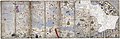
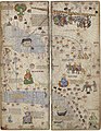
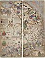
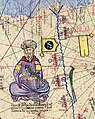
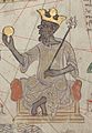
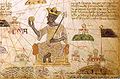
Català: L'Atles Català (1375) és el mapa cartogràfic català més important de l'edat mitjana, atribuït al jueu mallorquí Cresques Abraham. No està signat ni datat, i se sap que la data aproximada de producció és el 1375 pel registre que figura al calendari que l’acompanya.
English: The Catalan Atlas, credited to Cresques Abraham, Majorca 14th century
Français : Images tirées de l'Atlas Catalan (1375).
carta geografica del XIV secolo  | |||||
| Carica un file multimediale | |||||
| Istanza di | |||||
|---|---|---|---|---|---|
| Materiale usato | |||||
| Luogo | Parigi, Île-de-France, Francia metropolitana, Francia | ||||
| Creatore | |||||
| Collezione | |||||
| Data di fondazione o creazione |
| ||||
| Data di pubblicazione |
| ||||
| Larghezza |
| ||||
| Altezza |
| ||||
 | |||||
Sottocategorie
Questa categoria contiene le 3 sottocategorie indicate di seguito, su un totale di 3.
File nella categoria "Catalan Atlas"
Questa categoria contiene 94 file, indicati di seguito, su un totale di 94.
-
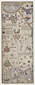
 Atles català.jpg 1 349 × 284; 130 KB
-
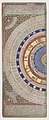
 Astronomical and cosmographical diagram.jpg 460 × 580; 134 KB
-
 Calendari Atles catala.jpg 466 × 592; 60 KB
-
 Catalan-Atlas - 1.png 800 × 1 019; 1,85 MB
-
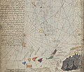
 1375 abraham cresques bnf 02 mediterrani oriental.jpg 3 201 × 4 113; 966 KB
-
 1375 Atlas Catalan Abraham Cresques (cropped).jpg 10 803 × 1 542; 10,94 MB
-
 1375 Atlas Catalan Abraham Cresques, Sea of Marmara.jpg 473 × 536; 161 KB
-
 1375 Atlas Catalan Abraham Cresques.jpg 11 811 × 3 850; 23,67 MB
-
 1375 Atlas Catalan, Black Sea 01.jpg 1 474 × 1 596; 1,23 MB
-
 1375 Atlas Catalan, Eastern Europe 01.jpg 1 818 × 1 628; 1,72 MB
-
 1375 Atlas Catalan, Eastern Mediterranean 01.jpg 1 454 × 1 558; 1,25 MB
-
 1375 Atlas Catalan, Europe 01.jpg 5 862 × 3 780; 12,04 MB
-
 1375 Atlas Catalan, Europe 02.jpg 2 931 × 1 890; 3,76 MB
-
 1375 Catalan Atlas by Abraham Cresques - Taprobana detail.jpg 1 342 × 741; 744 KB
-
 1375 Roystoch in Atlas Catalan.png 3 513 × 1 976; 8,09 MB
-
 Abraham Cresques Atlas de cartes-GogiMagog.jpg 1 500 × 1 566; 903 KB
-
 Anatolian Beyliks in the Catalan Atlas (1375).jpg 5 452 × 3 899; 35,22 MB
-
 Anatolian Beyliks in the Catalan Atlas (1375, detail).jpg 1 096 × 1 383; 2,46 MB
-
 Antechrist in the Catalan Atlas (1375).jpg 3 632 × 2 892; 10,4 MB
-
 Armenian Cilicia on 1375 Atlas Catalan.jpg 583 × 429; 83 KB
-
 Blason du royaume arménien de Cilicie.jpg 448 × 416; 29 KB
-
 Caravane sur la Route de la soie - Atlas catalan.jpg 1 356 × 1 144; 2,38 MB
-
 Catalan Atlas Ark on Ararat.jpg 531 × 354; 86 KB
-
 Catalan Atlas balck flags from Plate 10.png 1 411 × 1 636; 4,86 MB
-
 Catalan Atlas black flag from plate 11.png 1 147 × 2 276; 5,72 MB
-
 Catalan Atlas black flag in Yuka Kadoi, Plate 10.png 1 141 × 1 008; 2,42 MB
-
 Catalan Atlas BNF Sheet 6 Mansa Musa (cropped).jpg 1 856 × 2 118; 1,25 MB
-
 Catalan Atlas BNF Sheet 6 Mansa Musa.jpg 3 712 × 2 647; 1,41 MB
-
 Catalan Atlas BNF Sheet 6 Western Sahara.jpg 5 715 × 4 266; 3,7 MB
-
 Catalan Atlas BNF, back cover.jpg 6 412 × 15 994; 18,08 MB
-
 Catalan Atlas BNF, cover.jpg 6 399 × 15 590; 17,71 MB
-
 Catalan Atlas BNF, sheet 1.jpg 6 581 × 15 940; 15,89 MB
-
 Catalan Atlas BNF, sheet 10.jpg 6 403 × 15 755; 13,57 MB
-
 Catalan Atlas BNF, sheet 11.jpg 6 457 × 15 773; 14,47 MB
-
 Catalan Atlas BNF, sheet 12.jpg 6 475 × 15 809; 15,47 MB
-
 Catalan Atlas BNF, sheet 2.jpg 6 472 × 15 862; 14,18 MB
-
 Catalan Atlas BNF, sheet 3.jpg 6 453 × 15 862; 15,83 MB
-
 Catalan Atlas BNF, sheet 4.jpg 6 458 × 15 725; 15,64 MB
-
 Catalan Atlas BNF, sheet 5 (cropped).jpg 5 826 × 4 975; 4,19 MB
-
 Catalan Atlas BNF, sheet 5.jpg 6 454 × 15 862; 14,5 MB
-
 Catalan Atlas BNF, sheet 6.jpg 6 451 × 15 770; 15,61 MB
-
 Catalan Atlas BNF, sheet 7.jpg 6 457 × 15 778; 14,46 MB
-
 Catalan Atlas BNF, sheet 8.jpg 6 547 × 15 827; 14,2 MB
-
 Catalan Atlas BNF, sheet 9.jpg 6 474 × 15 870; 13,87 MB
-
 Cathay in the Catalan Atlas (1375).jpg 11 811 × 3 850; 48,91 MB
-
 Cilicie (Atlas Catalan, 1375).jpg 2 070 × 1 313; 391 KB
-
 City of Delhi in the Catalan Atlas (1375).jpg 1 424 × 1 389; 1,62 MB
-
 Compass rose from Catalan Atlas (1375).jpg 570 × 618; 158 KB
-
 Détail de l'Atalas Catalan - représentation de l'expédition de Jacme Ferrer.png 1 894 × 846; 3,4 MB
-
 Détail de l'Atlas Catalan - L'homme zodiacal.png 444 × 1 050; 1,1 MB
-
 Détail de l'Atlas Catalan - La reine de Saba.png 1 196 × 956; 2,54 MB
-
 Détail de l'Atlas Catalan - Les rois mages.png 1 920 × 1 080; 4,7 MB
-
 Détails de l'Atlas Catalan - Le roi Mansa Musa tenant une pépite d'or.png 1 392 × 1 034; 3,21 MB
-
 Détails de l'Atlas Catalan - Un membre de la tribu berbère des Sahandja.png 1 908 × 918; 4,3 MB
-
 EB1911 - Map - Fig. 23.—Catalan Map of the World (1375).jpg 520 × 199; 105 KB
-
 Empire of the Great Khan (Catayo) according to the Catalan Atlas (1375).jpg 4 482 × 3 850; 17,4 MB
-
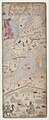
 Full 1 Atles Català BNF.jpg 1 153 × 1 491; 999 KB
-
 Full 2 Atles Català BNF.jpg 1 153 × 1 493; 1,03 MB
-
 Full 3 Atles Català BNF.jpg 1 156 × 1 503; 891 KB
-
 Full 4 Atles Català BNF.jpg 1 161 × 1 500; 941 KB
-
 Full 5 Atles Català BNF.jpg 1 159 × 1 496; 898 KB
-
 Full 6 Atles Català BNF.jpg 1 173 × 1 509; 1,01 MB
-
 Golden Horde in the Catalan Atlas (1375).jpg 5 950 × 4 158; 28,11 MB
-
 Il-Khanate in the Catalan Atlas (1375).jpg 6 009 × 6 269; 41,96 MB
-
 Ilkhanate in the Catalan Atlas (central panels).png 4 422 × 3 799; 32,94 MB
-
 Ilkhanate in the Catalan Atlas.png 11 811 × 3 850; 87,42 MB
-
 Ilkhante ship sailing the Indian Ocean towards India, in the Catalan Atlas (1375).jpg 3 663 × 2 300; 11,99 MB
-
 Issyk-kull in the Catalan Atlas.jpg 904 × 934; 240 KB
-
 Jacme ferrer.jpg 805 × 339; 295 KB
-
 Janibek.jpg 2 261 × 2 298; 833 KB
-
 Katalanischer Atlas 01.jpg 4 412 × 3 309; 4,09 MB
-
 King of Colombo (Kollam), Catalan Atlas 1375.jpg 3 011 × 3 194; 10,01 MB
-
 King of Colombo, Catalan Atlas 1375.jpg 2 166 × 2 540; 5,68 MB
-
 King of Delhi in Catalan Atlas 1375.jpg 5 568 × 3 993; 22,01 MB
-
 Kingdom of Chagatai in the Catalan Atlas (1375).jpg 2 767 × 2 846; 8,6 MB
-
 Kublai Khan in the Catalan Atlas (1375).jpg 990 × 1 594; 2,03 MB
-
 L’Atlas catalan,fol.9,det.png 2 063 × 1 010; 3,29 MB
-
 Mamluk Sultanate in the Catalan Atlas (1375), ruler and flags.jpg 619 × 777; 986 KB
-
 Mamluk Sultanate in the Catalan Atlas (1375).jpg 1 129 × 888; 1,36 MB
-
 African king from Catalan Atlas (1375).jpg 570 × 840; 198 KB
-
 Kanga Moussa Atlas Catalan.jpg 1 448 × 2 094; 869 KB
-
 Mansamusa.jpg 556 × 364; 17 KB
-
 Mapa Imperio de Mali.jpg 4 213 × 2 277; 15,11 MB
-
 Notices et extraits des manuscrits de la Bibliothèque du Roi - Vol. XIII, no 2 (1838).pdf 1 275 × 1 650, 154 pagine; 3,72 MB
-
 Oxag08.jpg 220 × 90; 29 KB
-
 Polonia Catalan Atlas (cropped).jpg 2 194 × 1 435; 4,37 MB
-
 Rey chabech, identified with Kebek Khan (1309-1326) in the Catalan Atlas, 1375.jpg 1 391 × 924; 1,49 MB
-
 Rois mages.jpg 466 × 250; 36 KB
-
 Senyeres atlas de Cresques.jpg 599 × 479; 66 KB
-
 Sultan of Delhi (top) and King of Vijayanagar (bottom) in the Catalan Atlas of 1375.jpg 5 860 × 6 720; 42,98 MB
-
 Sultan of Delhi Flag according to the Catalan Atlas (1375).png 2 714 × 1 280; 35 KB
-
 Taprobane in the Catalan Atlas (1375).jpg 2 766 × 1 766; 4,88 MB
-
 Three kings.tif 2 082 × 1 058; 4,6 MB
-
 Notices et extraits des manuscrits de la Bibliothèque du Roi - Vol. XIV, no 1 (1839).pdf 1 275 × 1 650, 170 pagine; 10,75 MB


.jpg)
.jpg)
.jpg)


.jpg)


.jpg)
.jpg)
.jpg)
.jpg)


_according_to_the_Catalan_Atlas_(1375).jpg)


.jpg)
.jpg)
.png)
.jpg)


,_Catalan_Atlas_1375.jpg)


.jpg)
.jpg)

,_ruler_and_flags.jpg)
.jpg)
.jpg)


.jpg)
_in_the_Catalan_Atlas,_1375.jpg)


_and_King_of_Vijayanagar_(bottom)_in_the_Catalan_Atlas_of_1375.jpg)
.png)
.jpg)
.jpg)
.jpg)
.jpg)
Categorie:
- 14th-century illuminated manuscripts from Spain
- Illuminated manuscripts created in Catalonia
- Illuminated manuscripts in the Bibliothèque nationale de France
- Illuminated manuscripts by name
- Maps created in 1375
- Maps showing 1375
- Mappae mundi
- Atlases of Spain
- Maps of the Crown of Aragon
- Medieval diagrams
- Maps of Cresques family
- Abraham Cresques