Category:Champillet
Vai alla navigazione
Vai alla ricerca
English: Champillet is a french city, located in the Indre department, in the region Centre-Val de Loire.
Français : Champillet est une commune française, située dans le département de l'Indre, en région Centre-Val de Loire.
| Posizione del soggetto | | Mappa di tutte le coordinate: OpenStreetMap |
|---|
comune francese   | |||||
| Carica un file multimediale | |||||
| Istanza di | |||||
|---|---|---|---|---|---|
| Luogo | |||||
| Indirizzo stradale |
| ||||
| Popolazione |
| ||||
| Superficie |
| ||||
| sito web ufficiale | |||||
 | |||||
Sottocategorie
Questa categoria contiene le 3 sottocategorie indicate di seguito, su un totale di 3.
File nella categoria "Champillet"
Questa categoria contiene 16 file, indicati di seguito, su un totale di 16.
-
 36038-Champillet-Sols.png 3 270 × 2 598; 1,54 MB
-
 Champillet (36) - Panneau de signalisation directionnelle de position.jpg 1 536 × 2 048; 1,4 MB
-
 Champillet (36) - Parc.jpg 2 048 × 1 536; 1,43 MB
-
 Champillet (36) - Route de La Châtre - vue vers Châteaumeillant.jpg 2 048 × 1 536; 1,26 MB
-
 Champillet (36) - Route de La Châtre - vue vers La Châtre.jpg 2 048 × 1 536; 1,34 MB
-
 Champillet (36) - Étang.jpg 2 048 × 1 536; 1,32 MB
-
 Champillet-FR-03-gite rural-a1.jpg 4 032 × 3 024; 6,36 MB
-
 Champillet-FR-03-mairie-a1.jpg 4 032 × 3 024; 4,91 MB
-
 Champillet-FR-03-mairie-a2.jpg 3 024 × 4 032; 4,73 MB
-
 Champillet-FR-03-minipelle Volvo ECR25D-a1.jpg 4 032 × 3 024; 5,81 MB
-
 Champillet-FR-03-panneau agglomeration-a1.jpg 3 024 × 4 032; 5,4 MB
-
 Champillet-FR-03-panneau agglomeration-a2.jpg 4 032 × 3 024; 3,17 MB
-
 Champillet-FR-03-panneau agglomeration-b1.jpg 4 032 × 3 024; 5,94 MB
-
 Champillet-FR-03-panneau agglomeration-b2.jpg 4 032 × 3 024; 5,57 MB
-
 Map commune FR insee code 36038.png 756 × 605; 30 KB
-
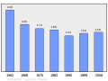 Population - Municipality code 36038.svg 475 × 355; 13 KB

_-_Panneau_de_signalisation_directionnelle_de_position.jpg)
_-_Parc.jpg)
_-_Route_de_La_Ch%C3%A2tre_-_vue_vers_Ch%C3%A2teaumeillant.jpg)
_-_Route_de_La_Ch%C3%A2tre_-_vue_vers_La_Ch%C3%A2tre.jpg)
_-_%C3%89tang.jpg)


