Category:Chelmsford
Naar navigatie springen
Naar zoeken springen
stad in Verenigd Koninkrijk   | |||||
| Media uploaden | |||||
| Is een |
| ||||
|---|---|---|---|---|---|
| Locatie | Chelmsford, Essex, East of England, Engeland | ||||
| Gelegen in of aan waterlichaam | |||||
| Inwonertal |
| ||||
| Oppervlakte |
| ||||
| Niet gelijk aan | |||||
| officiële website | |||||
 | |||||
Ondercategorieën
Deze categorie bevat de volgende 27 subcategorieën, van de 27 in totaal.
A
B
- Chelmsford bus station (9 B)
C
- Chelmer Valley Riverside (16 B)
- Chelmsford Crown Court (1 B)
- County Hall, Chelmsford (6 B)
- Chelmsford cricket ground (5 B)
E
G
- Guardian Figures (6 B)
H
- Hanningfield Reservoir (37 B)
M
N
P
- Plaques in Chelmsford (5 B)
- Pubs in Chelmsford (18 B)
R
- Chelmsford railway station (36 B)
S
- Shire Hall, Chelmsford (6 B)
- Snap Dragon Guitars (1 B)
T
W
Media in categorie "Chelmsford"
Deze categorie bevat de volgende 200 bestanden, van in totaal 242.
(vorige pagina) (volgende pagina)-
 "Back of Park View, 1906" - lovely view of this Victorian house. (7051647989).jpg 1.492 × 2.048; 331 kB
-
 ECR(1851) p59 - Chelmsford.jpg 1.927 × 1.092; 572 kB
-
 53 park central.jpg 800 × 533; 133 kB
-
 54, New Street (Q26434089).jpg 5.777 × 3.851; 5,07 MB
-
 A happy New Year (NBY 439593).jpg 3.600 × 2.388; 1,01 MB
-
 Annonay jumelages.jpg 2.985 × 4.579; 317 kB
-
 Road Sign, Chelmsford - geograph.org.uk - 418434.jpg 640 × 480; 135 kB
-
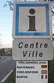
 Chelmsford Bridge in Backnang.jpg 3.937 × 3.227; 355 kB
-
 Allotments - geograph.org.uk - 414536.jpg 640 × 480; 112 kB
-
 Arcworks.jpg 1.024 × 683; 346 kB
-
 Arms of the Borough of Chelmsford (1889-1975).jpg 1.300 × 2.358; 360 kB
-
 Avon Road allotments - geograph.org.uk - 816910.jpg 492 × 640; 132 kB
-
 Band backdrop (18843010604).jpg 3.842 × 3.456; 1,99 MB
-
 Barclays Bank (Q26434108).jpg 4.858 × 3.886; 4,93 MB
-

-
 Bathtubs in repose - geograph.org.uk - 828087.jpg 482 × 640; 163 kB
-
 BBC Essex, Writtle Road - geograph.org.uk - 482471.jpg 640 × 482; 85 kB
-
 BBC Radio Essex, Chelmsford - geograph.org.uk - 418455.jpg 640 × 480; 102 kB
-
 Before or after the train^ Easter 2012 - panoramio.jpg 4.000 × 3.000; 4,84 MB
-
 Bell Tower on Oaklands House - August 2012 - panoramio.jpg 3.000 × 4.000; 3,27 MB
-
 Bell Tower through the trees - August 2012 - panoramio.jpg 2.900 × 2.347; 3,61 MB
-
 Below Thrift Wood - August 2012 - panoramio.jpg 4.000 × 3.000; 5,71 MB
-
 Beside Moulsham Thrift Wood - March 2013 - panoramio.jpg 4.000 × 3.000; 2,58 MB
-
 Between the railway and the old A12 - Easter 2012 - panoramio.jpg 4.000 × 3.000; 2,64 MB
-
 Between Thrift Wood and the River Wid - Easter 2012 - panoramio.jpg 4.000 × 3.000; 3,84 MB
-
 Bishops Hall Mill House - geograph.org.uk - 1074797.jpg 640 × 427; 112 kB
-
 Bridge 147, Widford Rd, Chelmsford - Easter 2012 - panoramio.jpg 3.000 × 4.000; 4,1 MB
-
 Britvicbuilding.jpg 1.632 × 1.232; 380 kB
-
 Canoe Club in Chelmsford Town Centre - August 2012 - panoramio.jpg 4.000 × 3.000; 6,26 MB
-
 Cereal to be harvested - August 2012 - panoramio.jpg 4.000 × 3.000; 5,64 MB
-
 Chain home.jpg 250 × 462; 16 kB
-
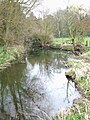
 Chelmer at Springfield - geograph.org.uk - 48559.jpg 482 × 640; 97 kB
-
 Chelmer from the A130 - geograph.org.uk - 48488.jpg 482 × 640; 124 kB
-
 Chelmer howe street tl698147.jpg 2.472 × 3.296; 4,46 MB
-
 Chelmer howe street tl699146.jpg 2.472 × 3.296; 3,71 MB
-
 Chelmsford and Essex Hospital (geograph 3356657).jpg 3.456 × 4.062; 2,54 MB
-

-
 Chelmsford Chieftains.jpg 720 × 479; 120 kB
-
 Chelmsford fire station - geograph.org.uk - 623751.jpg 640 × 427; 201 kB
-
 Chelmsford goods yard, March 2015 (20733993666).jpg 3.072 × 2.304; 1,33 MB
-
 Chelmsford RFC - geograph.org.uk - 215625.jpg 640 × 426; 83 kB
-
 Chelmsford River Cann.jpg 1.500 × 1.125; 1,08 MB
-
 Chelmsford Riverside Ice and Leisure Centre - geograph.org.uk - 1770399.jpg 1.024 × 768; 252 kB
-
 Chelmsford Star Co-op building, New London Road, Chelmsford (37953290171).jpg 3.072 × 2.304; 1,37 MB
-
 Chelmsford Star Co-operative, Barnard Road, Chelmsford (44611983115).jpg 3.072 × 2.304; 1,33 MB
-
 Chelmsford towerblocks - geograph.org.uk - 785017.jpg 480 × 640; 76 kB
-
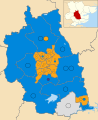 Chelmsford UK ward map 2023.svg 1.035 × 1.266; 606 kB
-
 Chelmsford, UK - panoramio (26).jpg 4.000 × 3.000; 1,52 MB
-
 Chelmsford, UK - panoramio (27).jpg 3.000 × 4.000; 1,66 MB
-
 Chelmsford, UK - panoramio (28).jpg 3.000 × 4.000; 1,78 MB
-
 Chelmsford, UK - panoramio (29).jpg 4.000 × 3.000; 2,47 MB
-
 Chelmsford, UK - panoramio (30).jpg 4.000 × 3.000; 3,42 MB
-
 Chelmsford, UK - panoramio (31).jpg 4.000 × 3.000; 2,29 MB
-
 Chelmsford. Carte-os-rb.jpg 567 × 297; 109 kB
-
 Chelmsford. Cb.jpg 170 × 230; 54 kB
-
 Church at Writtle - March 2013 - panoramio.jpg 4.000 × 3.000; 1,36 MB
-
 Corner of Wells Street CM1.jpg 1.284 × 1.032; 94 kB
-
 Council offices on Duke Street, Chelmsford (geograph 5488543).jpg 640 × 480; 81 kB
-
 County Ground Chelmsford Hayes Close End.jpg 4.160 × 1.280; 887 kB
-
 County Ground Chelmsford Pavilion.jpg 4.160 × 1.236; 1,31 MB
-
 County Ground Chelmsford River End.jpg 4.024 × 1.472; 1,34 MB
-
 Crop in the evening sun - August 2015 - panoramio.jpg 3.000 × 4.000; 1,8 MB
-
 Crossing the bridge - August 2012 - panoramio.jpg 4.000 × 3.000; 2,98 MB
-
 Cutting the cake (132812307).jpg 1.397 × 1.536; 826 kB
-
 Dancefloor (132842837).jpg 640 × 480; 108 kB
-
 Dog walkers by the River Wid - Easter 2013 - panoramio.jpg 4.000 × 3.000; 1,73 MB
-
 Downstream of the bridge - August 2012 - panoramio.jpg 4.000 × 3.000; 3,76 MB
-
 Electricity sub station - geograph.org.uk - 413549.jpg 640 × 480; 120 kB
-
 Electricity sub station - geograph.org.uk - 419416.jpg 640 × 480; 182 kB
-
 Essex Record Office (geograph 2244680).jpg 2.000 × 1.500; 1,45 MB
-
 Essex Records Centre adjacent to the River - August 2012 - panoramio.jpg 4.000 × 3.000; 4,3 MB
-
 Evening at the river side - August 2012 - panoramio.jpg 4.000 × 3.000; 6,63 MB
-
 Evening near the River Wid - Easter 2012 - panoramio.jpg 4.000 × 3.000; 5,02 MB
-
 Evening Reflection - River Wid - Easter 2012 - panoramio.jpg 4.000 × 3.000; 5,24 MB
-
 Evening reflections on the River Wid - August 2015 - panoramio.jpg 3.000 × 4.000; 1,47 MB
-
 Evening reflections under the arch - August 2015 - panoramio.jpg 3.000 × 4.000; 1,67 MB
-
 Fancy brickwork - August 2012 - panoramio.jpg 3.000 × 4.000; 6,46 MB
-
 Fire mark for Essex Economic Fire Office in Chelmsford, England.jpg 1.818 × 1.790; 767 kB
-
 Flag of Chelmsford.png 4.132 × 2.475; 828 kB
-
 Former Chelmsford Star Co-op Branch, Springfield Road.jpg 3.072 × 2.304; 1,38 MB
-
 Former Co-operative store, Writtle Road, Chelmsford. Dec 2011.jpg 3.264 × 2.448; 1,29 MB
-
 Galleywood from the River Wid - One dull evening Easter 2012 - panoramio.jpg 4.000 × 3.000; 2,42 MB
-
 Gasometers in Chelmsford - geograph.org.uk - 1237748.jpg 640 × 428; 66 kB
-

-
 Generals Lane - geograph.org.uk - 405753.jpg 640 × 428; 380 kB
-
 Gloster Meteor in Meteor Way, Chelmsford - geograph.org.uk - 418463.jpg 640 × 480; 105 kB
-
 Great and Little Leighs, UK - panoramio.jpg 1.840 × 3.264; 2,5 MB
-
 Great Baddow, Chain Home Tower.jpg 2.990 × 4.485; 7,61 MB
-
 Harvest ready below Galleywood - August 2012 - panoramio.jpg 4.000 × 3.000; 6,3 MB
-
 Hawkswood Road , Hanningfield Reservoir , Essex , September 2012 - panoramio.jpg 4.000 × 1.483; 1,09 MB
-
 Highchelmer.jpeg 2.400 × 1.800; 554 kB
-
 Highwood, UK - panoramio.jpg 1.840 × 3.264; 2,3 MB
-
 Holy Name Church, Chelmsford by Peter Stack Geograph 2181627.jpg 640 × 480; 78 kB
-
 Hylands - Easter 2013 - panoramio.jpg 4.000 × 3.000; 1,49 MB
-
 Hylands - March 2013 - panoramio (1).jpg 4.000 × 3.000; 1,65 MB
-
 Hylands - March 2013 - panoramio (2).jpg 4.000 × 3.000; 1,67 MB
-
 Hylands - March 2013 - panoramio.jpg 4.000 × 3.000; 1,5 MB
-
 Hylands from Widford - March 2013 - panoramio (1).jpg 4.000 × 3.000; 1,53 MB
-
 Hylands from Widford - March 2013 - panoramio.jpg 4.000 × 3.000; 1,39 MB
-
 Hylands House in the distance - August 2012 - panoramio.jpg 4.000 × 3.000; 5,1 MB
-
 Hylands Park - March 2013 - panoramio.jpg 4.000 × 3.000; 1,66 MB
-
 Hylands Park near Widford, August 2012 - panoramio.jpg 4.000 × 3.000; 2,5 MB
-
 Jugglers tools (18842759324).jpg 2.485 × 2.039; 2,47 MB
-
 Keene homes Almshouses and post boxes. Chelmsford - Flickr - sludgegulper.jpg 3.264 × 2.448; 1,53 MB
-
 Landslide (241440605).jpeg 2.048 × 1.365; 1.013 kB
-
 Light at the end... - panoramio.jpg 2.448 × 3.264; 467 kB
-
 Lodge House To Friend's Cemetary.jpg 4.032 × 2.268; 3,75 MB
-
 Map of Essex Sheet 052, Ordnance Survey, 1872-1890.tiff 10.742 × 7.171; 220,39 MB
-
 Maynetrees (Q26434090).jpg 5.597 × 3.731; 4,66 MB
-
 Meadow near Thrift Wood - August 2012 - panoramio.jpg 4.000 × 3.000; 4,8 MB
-
 Melbourneflats.jpg 800 × 600; 152 kB
-
 Mill across the meadow - August 2012 - panoramio.jpg 4.000 × 3.000; 5,45 MB
-

-
 Moulsham Mill - Chelmsford - geograph.org.uk - 47620.jpg 640 × 427; 62 kB
-
 Moulsham Thrift Wood - August 2015 - panoramio.jpg 3.000 × 4.000; 2,52 MB
-
 New footbridge near Widford - August 2015 - panoramio.jpg 4.000 × 3.000; 2,76 MB
-
 New London Rd - panoramio.jpg 600 × 800; 102 kB
-
 Newlands spring primary school.png 615 × 453; 610 kB
-
 North Melbourne Library (1).jpg 4.032 × 1.960; 2,8 MB
-
 North Melbourne Library.jpg 4.032 × 1.960; 2,75 MB
-
 Oaklands House - August 2012 - panoramio (1).jpg 4.000 × 3.000; 3,24 MB
-
 Oaklands House - August 2012 - panoramio.jpg 4.000 × 3.000; 4,92 MB
-
 Obelisk, Commemorating George Wray And Ann Wray (Q26614100).jpg 3.914 × 4.893; 4,53 MB
-
 Old girder and plank bridge above the weir - August 2012 - panoramio.jpg 4.000 × 3.000; 4,64 MB
-
 P9060136.JPG 3.072 × 2.304; 1,49 MB
-
 Parkside Court.jpg 1.458 × 1.946; 1,38 MB
-
 Parkway subway, Chelmsford - geograph.org.uk - 783320.jpg 640 × 497; 89 kB
-
 Part of Beaumont Otes Farm - geograph.org.uk - 766277.jpg 640 × 480; 113 kB
-
 Part of Chelmsford Centenary Circle - geograph.org.uk - 753107.jpg 640 × 480; 104 kB
-
 Part of St. John's Hospital - geograph.org.uk - 739610.jpg 640 × 448; 58 kB
-
 Path between railway and golf course - March 2013 - panoramio.jpg 3.000 × 4.000; 5,21 MB
-
 Picturesque Essex. The Friars, Chelmford (NBY 439731).jpg 3.600 × 2.331; 2,04 MB
-
 Post box. Ruskin road, Chelmsford. - Flickr - sludgegulper.jpg 2.448 × 3.264; 1,51 MB
-
 Power line junction - geograph.org.uk - 405609.jpg 640 × 428; 281 kB
-
 Railway bridge over the Wid - August 2012 - panoramio.jpg 3.000 × 4.000; 4,43 MB
-
 Railway over the River Wid - March 2013 - panoramio.jpg 4.000 × 3.000; 2,11 MB
-
 Ready to harvest - August 2012 - panoramio.jpg 3.000 × 4.000; 4,64 MB
-
 Reflection in evening light - March 2013 - panoramio.jpg 4.000 × 3.000; 2,67 MB
-
 Reflections - August 2012 - panoramio.jpg 4.000 × 3.000; 4,34 MB
-
 Reflections - evening - Easter 2012 - panoramio.jpg 3.000 × 4.000; 4,55 MB
-
 Reflections - March 2013 - panoramio.jpg 4.000 × 3.000; 4,12 MB
-
 RHP works from across Chelmer, 1990 - geograph.org.uk - 1074832.jpg 640 × 427; 90 kB
-
 River Can at Blackwall Bridge - geograph.org.uk - 119233.jpg 480 × 640; 156 kB
-
 River Can near the Canoe Club - August 2012 - panoramio.jpg 3.000 × 4.000; 6,79 MB
-
 River Chelmer - geograph.org.uk - 411097.jpg 640 × 480; 49 kB
-
 River Chelmer - geograph.org.uk - 48300.jpg 640 × 427; 71 kB
-
 River confluence - geograph.org.uk - 790907.jpg 640 × 487; 117 kB
-
 River Wid - August 2012 - panoramio (1).jpg 4.000 × 3.000; 3,96 MB
-
 River Wid - August 2012 - panoramio.jpg 3.000 × 4.000; 5,03 MB
-
 River Wid - evening at Easter 2012 - panoramio.jpg 4.000 × 3.000; 2,96 MB
-
 River Wid - March 2013 - panoramio.jpg 4.000 × 3.000; 2,03 MB
-
 River Wid in Hylands Park - March 2013 - panoramio.jpg 4.000 × 3.000; 2,26 MB
-
 River Wid in the Park - March 2013 - panoramio.jpg 3.000 × 4.000; 2,08 MB
-
 River Wid over the bridge - August 2012 - panoramio.jpg 4.000 × 3.000; 6,27 MB
-
 River Wid through the ornate bridge - August 2012 - panoramio.jpg 3.000 × 4.000; 5,21 MB
-
 Rivercan.jpg 1.024 × 683; 513 kB
-
 Riverside - geograph.org.uk - 411101.jpg 640 × 480; 52 kB
-
 Riverside Ice and Leisure, Chelmsford.jpg 1.824 × 1.368; 1,76 MB
-
 Rose Cottage (Q26614114).jpg 3.864 × 3.091; 4,55 MB
-
 Roundabout in Springfield - geograph.org.uk - 215556.jpg 640 × 426; 88 kB
-
 Sandford road Post Office, Chelmsford Dec 2011 - Flickr - sludgegulper (1).jpg 2.448 × 3.264; 1,37 MB
-
 Sandford road Post Office, Chelmsford Dec 2011 - Flickr - sludgegulper (2).jpg 3.264 × 2.448; 1,36 MB
-
 Sandford road Post Office, Chelmsford Dec 2011 - Flickr - sludgegulper.jpg 3.264 × 2.448; 1,39 MB
-
 School Playing fields beside the river - August 2012 - panoramio.jpg 4.000 × 3.000; 2,6 MB
-
 School Sports Ground by the River - Easter 2013 - panoramio.jpg 4.000 × 3.000; 2,24 MB
-

-
 Site of future bridge, June 1985 - geograph.org.uk - 1613090.jpg 640 × 428; 111 kB
-
 Skeleton tree - Easter 2012 - panoramio.jpg 3.000 × 4.000; 4,07 MB
-
 Skeleton Tree - March 2013 - panoramio.jpg 4.000 × 3.000; 1,44 MB
-
 Skeleton tree with crow - August 2012 - panoramio.jpg 3.000 × 4.000; 4,77 MB
-
 Skeleton Trees waiting for spring - March 2013 - panoramio.jpg 4.000 × 3.000; 2,76 MB
-
 South Lodge Hotel, New London Road - geograph.org.uk - 482453.jpg 640 × 482; 128 kB
-
 South Lodge Hotel, New London Road - geograph.org.uk - 482475.jpg 640 × 482; 101 kB
-
 Speed and stillness - Easter 2012 - panoramio.jpg 4.000 × 3.000; 5,28 MB
-
 Spire of Galleywood Church - August 2012 - panoramio.jpg 3.000 × 4.000; 4,52 MB
-
 Sports Ground - 3 Mile Hill - March 2013 - panoramio.jpg 4.000 × 3.000; 2,72 MB
-
 Sports Ground - 3 Mile Hill, Widford - March 2013 - panoramio.jpg 4.000 × 3.000; 1,9 MB
-
 Sports Relief mile - geograph.org.uk - 411086.jpg 480 × 640; 83 kB
-
 Spring on the river - geograph.org.uk - 800069.jpg 479 × 640; 127 kB
-
 Springfield Hall Park - geograph.org.uk - 800075.jpg 481 × 640; 74 kB
-
 St Mary's - August 2012 - panoramio.jpg 3.000 × 4.000; 4,26 MB
-
 St Mary's at Widford in the evening - August 2012 - panoramio.jpg 3.000 × 4.000; 2,54 MB
-
 St Mary's in the morning - August 2012 - panoramio.jpg 3.000 × 4.000; 4,67 MB
-
 St. Andrew's church - geograph.org.uk - 764420.jpg 640 × 424; 58 kB
-

-

-
 Stilt people (18844685103).jpg 2.756 × 3.456; 2,22 MB
-
 Stilt people (19279189899).jpg 3.239 × 3.193; 1,68 MB
-
 Storm Damage 1987.jpg 640 × 428; 221 kB
-
 Summer in Essex - August 2012 - panoramio.jpg 4.000 × 3.000; 3,26 MB
-

-
 Temple farm - South side - panoramio (1).jpg 4.160 × 3.120; 5,04 MB
-
 The Co-operative Meadgate Avenue, Chelmsford.jpg 3.264 × 2.448; 1,15 MB
-
 The Co-operative, Kings Road, Chelmsford.jpg 1.306 × 979; 357 kB
-
 The Co-operative, Melbourne, Chelmsford.jpg 1.306 × 979; 216 kB
-
 The Co-operative, Moulsham Street, Chelmsford.jpg 3.072 × 2.304; 1,38 MB
-
 The Edge of Meepsehole Wood - geograph.org.uk - 72955.jpg 482 × 640; 131 kB
-

-
 The farmhouse at Elm Farm - geograph.org.uk - 753056.jpg 640 × 439; 75 kB
-
 The Fling Festival 2015 (18845283203).jpg 3.456 × 4.608; 4,25 MB
.jpg)
_p59_-_Chelmsford.jpg)

.jpg)
.jpg)


.jpg)

.jpg)
.jpg)


.jpg)


.jpg)


.jpg)
.jpg)


.jpg)
.jpg)
.jpg)
.jpg)
.jpg)
.jpg)


.jpg)


.jpg)
.jpg)


.jpg)


.jpg)


.jpg)
.jpg)

.jpg)


.jpg)

.jpeg)


.jpg)


.jpg)

.jpg)

.jpg)


.jpg)


.jpg)


.jpg)

.jpg)
.jpg)


.jpg)
.jpg)


.jpg)


.jpg)