Category:Chinese domination of Vietnam
Zur Navigation springen
Zur Suche springen
English: Chinese domination of Vietnam
Tiếng Việt: Bắc thuộc
中文:北屬
Chinese colonization and occupation of Vietnam from 111 BC to 938 AD and from 1407 to 1427 | |||||
| Medium hochladen | |||||
| Ist ein(e) |
| ||||
|---|---|---|---|---|---|
| Ort |
| ||||
| Besteht aus |
| ||||
| Startzeitpunkt |
| ||||
| Endzeitpunkt |
| ||||
| |||||
Unterkategorien
Es werden 2 von insgesamt 2 Unterkategorien in dieser Kategorie angezeigt:
In Klammern die Anzahl der enthaltenen Kategorien (K), Seiten (S), Dateien (D)
F
Y
Medien in der Kategorie „Chinese domination of Vietnam“
Folgende 46 Dateien sind in dieser Kategorie, von 46 insgesamt.
-
 1bgdgdgd.jpg 873 × 629; 99 KB
-
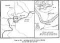
 AiChiLang map.JPG 2.280 × 1.678; 964 KB
-
 AiChiLang.JPG 2.528 × 1.798; 1,03 MB
-
 Cerámica vietnamita Guimet 08.JPG 4.941 × 3.182; 3,17 MB
-
 Chi Lăng 1.jpg 4.608 × 3.456; 5,19 MB
-
 Chi Lăng 2.jpg 4.255 × 3.043; 2,01 MB
-
 Chi Lăng 3.jpg 4.369 × 3.206; 2,39 MB
-
 Chi Lăng 4.jpg 4.608 × 3.456; 3,05 MB
-
 China Historic Ming Empire.jpg 950 × 900; 787 KB
-
 Chine Ming - provinces Yongle-es.svg 628 × 641; 598 KB
-
 Chine Ming - provinces Yongle.svg 628 × 641; 641 KB
-
 Gdgdgdgd.jpg 664 × 651; 100 KB
-
 Indochina - Sègle V.png 545 × 726; 97 KB
-
 Khoi nghia lam son 500 01 (1) (Copy).jpg 1.000 × 1.466; 139 KB
-
 LieuThangthach.JPG 1.563 × 2.185; 744 KB
-
 Luoc do nghia quan lam son tien quan ra bac 500.jpg 500 × 465; 122 KB
-
 Luoc do tran chi lang - xuong giang thang.jpg 580 × 757; 71 KB
-
-
 Map of Ming Chinese empire 1415 (cropped).jpg 1.440 × 2.178; 389 KB
-
 Map of Ming Chinese empire 1415.jpg 1.577 × 2.339; 451 KB
-
 Ming China and Asia.jpg 250 × 332; 33 KB
-
 Ming Domination of Vietnam.jpg 388 × 387; 63 KB
-
 Ming Dynasty 1368 – 1644 (AD).PNG 802 × 741; 44 KB
-
 Ming Dynasty 1415 chinese.png 556 × 537; 94 KB
-
 Ming Dynasty 1415.png 556 × 537; 92 KB
-
 Ming Dynasty Administrative division.jpg 3.348 × 2.542; 447 KB
-
 Mingská Čína za největšího rozmachu.jpg 3.632 × 3.496; 1,34 MB
-
 Newone - tượng Bà Triệu núi Nưa.jpg 1.706 × 2.275; 717 KB
-
 Provincie říše Ming éry Jung-le.svg 628 × 641; 910 KB
-
 Quymon.JPG 2.844 × 1.378; 978 KB
-
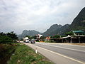
 Quốc lộ 1A, đoạn Chi Lăng.jpg 4.608 × 3.456; 4,17 MB
-
 TienquanvaoNgheAnLeLoi.jpg 579 × 805; 106 KB
-
 Trận Chi Lăng - Xương Giang.png 802 × 1.148; 287 KB
-
 Trận Tốt Động Chúc Động 1426.jpg 500 × 383; 59 KB
-
 Tuong dai chien thang Chi Lang.JPG 1.604 × 1.990; 599 KB
-
 TuongBaTrieu.jpg 1.690 × 1.080; 802 KB
-
 Vietnam del nord, modellino di stalla, da prov. di thanh hoa, lach tuong, I-III sec. dc.JPG 2.536 × 1.760; 1,86 MB
-
 万历年间的明朝(简).png 1.343 × 1.206; 1,5 MB
-
 万历年间的明朝(繁).png 1.343 × 1.206; 1,5 MB
-
 張輔.jpg 500 × 639; 110 KB
-
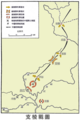 支棱戰圖.png 802 × 1.203; 425 KB
-
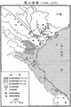
 明·交趾.jpg 8.090 × 10.906; 9,01 MB
-
 明成祖時期疆域.png 516 × 427; 226 KB
-
 永乐年间的明朝(简).png 1.343 × 1.158; 920 KB
-
 藍山起義圖.png 791 × 1.184; 735 KB
-
 郑和下西洋路线图.png 506 × 236; 61 KB


_(Copy).jpg)


_-_Museum_of_Vietnamese_History_-_Ho_Chi_Minh_City_-_DSC06005.JPG)
.jpg)


.PNG)


